 Block
From the record
17 National Register listings published here.
Sources: the county history on the Internet Archive · the National Register database, National Park Service
70 topographic sheets cover 69 settlements here, and 17 properties are on the National Register of Historic Places.
17 National Register listings published here.
Sources: the county history on the Internet Archive · the National Register database, National Park Service
Every property in this county listed on the National Register of Historic Places, with the year it was listed and the federal nomination document.
| Photograph | Property | Type | Listed | Reference |
|---|---|---|---|---|
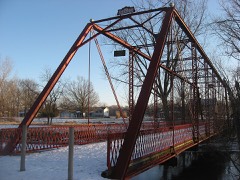 | Chinworth Bridge | structure | 1997 | 96001546 |
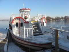 | DIXIE (sternwheeler) | structure | 2009 | 09000757 |
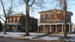 | East Fort Wayne Street Historic District | building | 1993 | 93000472 |
 | Hall Farm | building | 1992 | 92001164 |
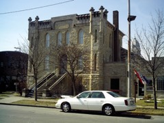 | Kosciusko County Jail | building | 1978 | 78000036 |
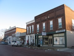 | Leesburg Historic District | district | 1993 | 93000465 |
 | Little Crow Milling Company Factory | building | 2018 | 100002488 |
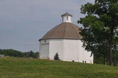 | Robert Orr Polygonal Barn | building | 1993 | 93000190 |
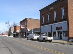 | Pierceton Historic District | district | 1992 | 92001147 |
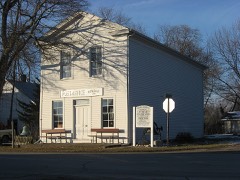 | John Pound Store | building | 1992 | 92000672 |
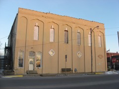 | Silver Lake Historic District | district | 1992 | 92001148 |
| Warner House-Warner Schoolhouse | building | 2023 | 100009298 | |
 | Warsaw Courthouse Square Historic District | district | 1982 | 82000046 |
| Warsaw Courthouse Square Historic District (Boundary Increase) | district | 1993 | 93000952 | |
 | Warsaw Cut Glass Company | building | 1984 | 84001059 |
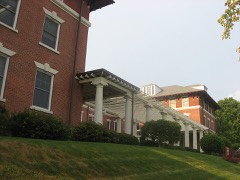 | Winona Lake Historic District | district | 1993 | 93001411 |
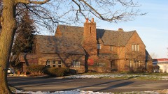 | Justin Zimmer House | building | 1991 | 91001865 |
Every wildfire the federal occurrence database records inside this county: 3 of them, burning about 7 acres. None started naturally and none was recorded as arson. Each settlement page carries the fires within five miles of it.
| Reported cause | Fires |
|---|---|
| Missing data/not specified/undetermined | 1 |
| Recreation and ceremony | 1 |
| Equipment and vehicle use | 1 |
The five largest, by the area the report gives. None of them was recorded as arson.
| Date | Cause | Size | Reported by | Name on the report |
|---|---|---|---|---|
| 2 April 2003 | Missing data/not specified/undetermined | 6.0 acres | Indiana State Fire Marshal's Office | not named |
| 2 April 2003 | Equipment and vehicle use | 1.0 acres | Indiana State Fire Marshal's Office | not named |
| 26 March 2002 | Recreation and ceremony | under an acre | Indiana State Fire Marshal's Office | not named |
Every settlement page carries the fires within five miles of it - see the settlement index below.
The NOAA Storm Events Database holds 519 reports for this county, causing 2 deaths, 78 injuries and about $17,024,500 in recorded property damage. Each settlement page carries the reports that name it.
| Kind of event | Reports |
|---|---|
| Thunderstorm Wind | 349 |
| Hail | 105 |
| Tornado | 35 |
| Lightning | 12 |
| Flash Flood | 8 |
| Flood | 6 |
| Heavy Rain | 3 |
| Funnel Cloud | 1 |
The most serious of them, by death, then injury, then recorded damage. The accounts are quoted exactly as the forecast office filed them.
| When | Event | Place named | Harm | What the report says |
|---|---|---|---|---|
| April 1974 | Tornado (F4) | not stated | 1 killed, 39 hurt | no account filed |
| July 2014 | Thunderstorm Wind | Warsaw | 1 killed | Emergency management officials reported a large, rotten tree fell onto the bedroom of a mobile home in the Fairlane Mobile Home Park. Two adults and two children were inside the home at the time. One child escaped the impacted room, but a 14 year old male did not and was subsequently killed. |
| October 2001 | Tornado (F1) | Mentone | 14 hurt, $2,500,000 | no account filed |
| July 1988 | Thunderstorm Wind | not stated | 6 hurt | no account filed |
| October 1967 | Tornado (F2) | not stated | 5 hurt, $250,000 | no account filed |
| June 1998 | Tornado (F1) | Etna Green | 4 hurt, $800,000 | THIS WAS ANOTHER TORNADO SPAWNED FROM THE SAME TORNADIC SUPERCELL THAT CAUSED DAMAGE IN PULASKI COUNTY EARLIER IN THE EVENING. 30 MOBILE HOMES AT THE MIKEL MOBILE ESTATES WERE DAMAGED, MANY SEVERELY. SOME WERE SIMPLY OVERTURNED WHILE OTHERS WERE COMPLETELY FLATTENED. 4 PEOPLE SUSTAINED MINOR INJURIES. |
| July 1961 | Tornado (F3) | not stated | 3 hurt, $25,000 | no account filed |
| June 1991 | Thunderstorm Wind | not stated | 3 hurt | no account filed |
| August 2022 | Thunderstorm Wind | Claypool | 2 hurt, $20,000 | Dispatch indicates a tree is down on a vehicle with two people trapped. |
| June 1980 | Tornado (F1) | not stated | 1 hurt, $25,000 | no account filed |
| November 2016 | Thunderstorm Wind | Etna Green | 1 hurt | Emergency management officials reported a tree was blown down onto a vehicle. One occupant was injured. |
| May 2009 | Thunderstorm Wind | Mentone | $5,000,000 | Emergency management officials reported two livestock barns, containing chickens, suffered damage. One building suffered severe damage with roughly 200,000 chickens having to be relocated. Debris from the barns was thrown up to a half mile northeast of the location, with a barn on 900 West south of 100 North suffering some damage. Damage by the business owners is estimated in excess of five million dollars due to structural damage, costs to move the chickens to other facilities and other expenses. |
| October 2007 | Tornado (EF2) | Nappanee | $3,000,000 | The tornado continued tracking northeast from Marshall county into extreme northwestern Kosciusko county. 116 structures were reported to have some sort of damage. 17 homes were destroyed, 6 suffered major damage and 17 minor damage. A horse was killed in a barn that was destroyed. Damage estimated around 3 million dollars. |
| September 2024 | Thunderstorm Wind | Warsaw Arpt | $500,000 | A thunderstorms produced a series of microbursts along an approximately 10 mile path, starting just south of Leesburg and ending near the Whitley county line. Numerous trees were broken or uprooted as well as many tree branches snapped. Multiple structures and power lines were impacted by the falling trees, causing pockets of damage, which centered on the Chapman Lake area. Winds were estimated in the 60 to 80 mph range, highest in the Chapman Lake area. |
| July 2011 | Thunderstorm Wind | Winona Lake | $500,000 | A survey of widespread damage, as well as possible tornado sightings, was performed by NWS officials. A two to three mile wide area of damage was found across the southern part of Warsaw, into much of the Village of Winona Lake. Eyewitness and video footage indicates that a funnel had formed on the leading edge of the storm just prior to the wind damage. No indications of the funnel touching down could be located. However, damage patterns and video footage indicated a downburst occurred. Winds were not fully able to reach the ground, with damage confined to numerous trees being snapped at higher levels or uprooted. Power poles and lines were also knocked down, mainly due to falling trees and tree limbs. Reports of trees falling onto several homes and cars were also received with no injuries noted. Some roof damage was observed in a few locations, including Warsaw Foundry, TTP, Inc. and Whimet, Inc. Winds were estimated between 85 and 90 mph. No specific damage figures were available, but estimates of at least $500,000 are being entered. |
| July 1998 | Thunderstorm Wind | Warsaw | $500,000 | NUMEROUS TREES DOWN IN TOWN. ONE HOME COMPLETELY DESTROYED BY LARGE FALLEN TREE WHICH CRUSHED THE THEN UNOCCUPIED HOME. A TENTS AT THE COOK CHAPEDL CHURCH WERE BLOWN AWAY AND NEVER FOUND. SEVERAL OTHER HOMES SUFFERED MINOR TO MODERATE DAMAGE ESPECIALLY TO ROOFS FROM FALLEN TREES AND LIMBS. |
| June 2010 | Tornado (EF1) | Monoquet | $300,000 | A storm survey by NWS personnel indicated a weak circulation embedded in a initially stronger microburst south of US-30. Lofting of debris from a destroyed pole barn was evident in the area suggesting the tornado touched down near a residence south of Fox Farm Road, near North 200 West. The circulation continued to intensify as it tracked southeast into the Center Lake area. Numerous trees were damaged or uprooted along the track with a manufactured home being shifted off its blocks. As the tornado passed over State Route 15, it impacted the Warsaw Foundry, causing the southwest portion of the roof of a building to be torn off (DI: MBS, DOD: 3). The circulation continued across Pike Lake, causing damage to several homes and apartments as well as uprooting trees around the lake and an adjacent cemetery. As it approached U.S. 30, the circulation crossed a large residential area just south of the Kosciusko Community Hospital, uprooting several trees. One large tree fell into the center of a home on Parker Street, destroying it. The circulation crossed US 30 and began to weaken with scattered tree damage. The circulation finally dissipated along Old US 30 east of South 250 East. Maximum winds were estimated around 100 mph. Damage is estimated at $300,000. |
| March 2006 | Thunderstorm Wind | Milford | $265,000 | A survey of damage at the Maple Leaf Farms Distribution center, southeast of Milford, concluded that straight line winds were the cause of damage to a cold storage building. As winds striking the west side of the building interacted with the pressure within the cold storage vault, causing a vacuum that resulted in numerous panels, as well as insulation, being pulled off the building. The refrigeration equipment did not suffer any damage. However, much of its contents were exposed to the outside air, resulting in some loss of the food. Roof damage was also reported at 3 smaller buildings. As the winds continued east, trees and power lines were knocked down in an around Blueberry Island, on Dewart Lake. Damage is estimated at $250,000 at Maple Leaf Farms and roughly $15,000 on Blueberry Island. |
| June 1998 | Thunderstorm Wind | Mentone | $250,000 | MANY LARGE TREES WERE BLOWN DOWN THROUGHOUT TOWN. SEVERAL HOUSES SUSTAINED MINOR TO MODERATE STRUCTURAL DAMAGE. |
| July 1998 | Lightning | Packerton | $250,000 | A LIGHTNING INDUCED FIRE COMPLETELY DESTROYED THE PACKERTON FOREST PRODUCTS PLANT. |
| August 1956 | Tornado (F3) | not stated | $250,000 | no account filed |
| January 2008 | Flood | Mentone | $200,000 | Numerous roads were either closed or had high water signs up for several days due to rainfall of 2 to 4 inches across the county. Several creeks and the Tippecanoe river also went over their banks, causing part of the flooding problems in addtion to creeks, ditches and low areas filling beyond capacity. No exact damage figures are available but are estimated at $200,000. |
| June 2000 | Tornado (F2) | Sidney | $200,000 | The last farm was hit when the tornado was located just west of 1300 S and 400 E in Kosciusko County. Two barns, a garage, and several outbuildings were completely destroyed with some of the foundations swept clean. The house and two cars were severely damaged from large pieces of flying debris. A 17 foot boat was thrown about 20 yards and severely damaged. Most of the trees on this farm were destroyed. Debris from this farm was carried up to one half mile away as the tornado crossed 400 E and then lifted back into the clouds. |
| July 1998 | Thunderstorm Wind | Pierceton | $200,000 | A HOUSE WAS FLATTENED BY A LARGE OAK TREE. NO ONE WAS HOME AT THE TIME FORTUNATELY. |
| August 2007 | Thunderstorm Wind | Barbee | $150,000 | A wet microburst with estimated winds of 80 mph caused numerous trees, tree limbs and power lines to be blown down around Barbee Lake, Kuhn Lake and extending northeast to southeast of North Webster. Damage is estimated at $150,000. |
| September 2000 | Lightning | Warsaw | $150,000 | Lightning struck a barn causing a fire which gutted the barn and its contents. |
| July 2022 | Thunderstorm Wind | Oswego | $100,000 | Trees down on mobile homes around Chapman Lake. Reported via Facebook. |
| June 2022 | Thunderstorm Wind | Syracuse | $100,000 | A survey of damage indicated the swath of wind damage continued southeast from Elkhart county, first impacting Syracuse then progressing SSE into North Webster and points to the southeast towards the Noble county line. Tree damage was not widespread in Syracuse, but several tree limbs and trees were noted down across the city. The winds began to accelerate further as they moved off Lake Wawasee and just east of the NWS Northern Indiana office. One of the apartment complexes at Baypoint condos suffered roof damage as the winds caught a corner of the roof that was not properly anchored, causing loss of several pieces plywood and impacting 2 apartments with mainly water damage. The noted tree damage increased on the south side of North Webster and Webster Lake. While overall wind speeds of 60 to 70 mph were estimated, pockets of locally higher gusts likely occurred. |
| May 2009 | Flash Flood | Syracuse | $100,000 | Spotters and local officials reported between two and four inches of rain falling over a 3 to 5 hour period. This resulted in numerous roads becoming flooded with flowing water in several locations, especially south of Warsaw. At least 6 roads were reported closed due to the flowing water. Specific damage amounts werent available, but are estimated at $100,000. |
| April 2006 | Lightning | Sidney | $100,000 | Lightning struck the transmission tower of WLZQ-FM, damaging the main transmitter beyond repair. Service was fully restored in early May. Damage estimates to replace the transmitter are around $100,000. |
| March 2025 | Thunderstorm Wind | Hastings | $80,000 | Multiple irrigation systems rolled and mangled. |
| September 2017 | Lightning | Enchanted Hills | $75,000 | Residents of a home on the northeast side of Lake Wawasee reported a loud crack around 6 am EDT during a thunderstorm. Shortly after, smoke was noted and the residents evacuated. Fire spread across much of the home with the greatest damage in the second story and garage areas. Damage is estimated at around $75,000. |
| February 2018 | Flood | Nappanee | $56,000 | High water levels and subsequent flooding issues were seen across much of the county as the over 100 lakes and various creeks, streams and rivers struggle dto handle the runoff of flood waters. Several roads were closed or marked for high water. Damage was estimated at around 56,000 dollars. |
| May 2007 | Thunderstorm Wind | Milford | $50,000 | Sporadic tree and power line damage was reported across the county. However the highest concentration of damage was found along a path from Hastings to Milford. In and around the Hastings area, A house suffered damage to a add on room where the shingles were peeled off and thrown into the yard. Numerous trees and power lines down in the town of Milford, closing several streets, with a partially rotten tree falling onto a parked van, destroying the back half of the van and lifting the front right wheel off the ground several inches. |
| August 2001 | Lightning | Burket | $50,000 | Lightning struck a house on CR 900S. When the lightning bolt hit the house items were knocked off the wall and electrical sockets were blown out of the wall. Damage to the residence was estimated at $50,000. |
| June 1999 | Thunderstorm Wind | Milford | $50,000 | 13 large trees were blown down in town. A metal roof was torn off a machine and tool shop. A pickup truck was damaged when a large tree was toppled onto it. |
| August 1998 | Thunderstorm Wind | Syracuse | $50,000 | SEVERAL TREES AND POWER LINES DOWN. |
| August 1998 | Thunderstorm Wind | Milford | $50,000 | SEVERAL TREES AND POWER LINES DOWN. |
| April 1994 | Thunderstorm Wind | not stated | $50,000 | Sixty mph winds blew roofs off of sheds and downed power lines across the northern part of the county. |
| June 1994 | Thunderstorm Wind | Leesburg | $50,000 | A tractor semi-trailer was blown over and damaged. Downed trees blocked several roads. |
| August 1993 | Thunderstorm Wind | Warsaw | $50,000 | Antennas and trees were downed, and roofs were damaged. |
| May 2025 | Thunderstorm Wind | Oswego | $40,000 | Large tree snapped at the base and fell onto N Kalorama Rd. A truck was crushed. A power pole was snapped. |
| May 2007 | Lightning | Warsaw | $40,000 | Fire officials were dispatched to a residence in the Harrison Landing subdivision of Warsaw where lightning struck a house. The fire was contained within 30 minutes. No one was injured in the fire. Damage was estimated at around $40,000. |
| March 2025 | Thunderstorm Wind | North Webster | $30,000 | Tree down on parked vehicle and lines down near Epworth Forest. |
| April 2025 | Thunderstorm Wind | Wawasee | $30,000 | Tree and powerlines down onto a vehicle across N Hillside Drive. |
| July 2021 | Lightning | Oswego | $30,000 | Lightning strike caused structural fire that destroyed a garage and damaged a house. |
| July 1999 | Thunderstorm Wind | Etna Green | $25,000 | Power lines were downed from Etna Green to Atwood. |
| June 1957 | Tornado (F2) | not stated | $25,000 | no account filed |
| April 1956 | Tornado (F3) | not stated | $25,000 | no account filed |
| March 2025 | Thunderstorm Wind | Clunette | $20,000 | Numerous reports of limbs, trees, and powerlines down around Kosciusko county. There was a tree down on a vehicle near Epworth Forest. |
| July 2024 | Thunderstorm Wind | Sidney | $20,000 | Large tree down onto a house. |
| August 2022 | Thunderstorm Wind | Warsaw | $20,000 | Several trees are down in the neighborhood. Some of the trees are blocking the road. |
| July 2009 | Lightning | Atwood | $20,000 | Lightning struck a tree adjacent to a mobile home in the West Haven Estates, traveled along a tree root and blew a hole in the floor of the home. A woman in the trailer heard a loud band and then observed her couch on fire. She, another adult and 2 children were able to escape unharmed. Damage was estimated at around $20,000. |
| June 2001 | Thunderstorm Wind | North Webster | $20,000 | Large tree down crushed side of small house. |
| August 2001 | Lightning | Warsaw | $20,000 | Lightning apparently started a fire which destroyed a barn near the intersection of CR 450S and County Farm Road. The remains of the barn were discovered around 1:20 am EST by a Kosciusko County Sheriff's deputy on routine patrol. |
| March 2025 | Thunderstorm Wind | Etna Green | $15,000 | Metal hog barn roof torn off and thrown throughout two fields. |
| December 2008 | Thunderstorm Wind | Nappanee | $15,000 | A brief downburst caused a wood framed, sheet metal pole barn to be blown off its concrete foundation. The survey revealed the wind struck the south facing door and caused the entire building to be lifted and then deposited next to the foundation. The owner of the building could not remember if the doors were open or not prior to the winds. Wind speeds were estimated between 60 and 65 mph. Damage is estimated at around $15,000. |
| February 2008 | Flood | Milford | $15,000 | Water was reported over State Route 15, near Milford. Numerous other county roads had high water including a few road closures due to standing water. |
| May 2007 | Thunderstorm Wind | Warsaw | $15,000 | A maple tree fell onto a business in Winona Lake causing roof damage to the building. |
| May 2025 | Thunderstorm Wind | Warsaw | $10,000 | Tree and power lines down near CR 300 E and Old US 30. |
The Survey's mineral resources record lists 9 workings inside this county. 6 still produce and 3 are closed or unrecorded. Each settlement page carries the workings within five miles of it.
| Commodity | Workings |
|---|---|
| Sand and Gravel, Construction | 8 |
| Stone | 1 |
The least common of them first, because a county's hundredth gravel pit says nothing its first ten did not.
| Where | Site | Commodity | Status | Recorded |
|---|---|---|---|---|
| Warsaw Street Dept. | Stone | Producer | ||
| Fuller's Sand & Gravel Pit | Sand and Gravel, Construction | Past Producer | ||
| G. and G. Sand and Gravel Pit | Sand and Gravel, Construction | Past Producer | ||
| J & M Gravel Pit | Sand and Gravel, Construction | Producer | ||
| Kosciusko Co. Hwy. Dept. | Sand and Gravel, Construction | Producer | ||
| Kosciusko County Pit | Sand and Gravel, Construction | Producer | ||
| Leesburg Sand & Gravel | Sand and Gravel, Construction | Producer | ||
| Pit | Sand and Gravel, Construction | Past Producer | ||
| Zimmerman Gravel Pit | Sand and Gravel, Construction | Producer |
A Standard History of Kosciusko County, Indiana : an Authentic Narrative of the Past, with Particular Attention to the Modern Era in the Commercial, Industrial, Educational, Civic and Social Development. A Chronicle of the People with Family Lineage and Memoirs devotes a chapter to each township: its boundaries and streams, who settled it and when, the mills, the schools and the churches. All 14 are reproduced here in full. Each row shows the township's own shape and where it lies in the county, drawn from the Census Bureau's boundary. Which settlements belong to which township is computed from that same boundary, not taken from the book.
2 books written about this county, cut here where the book itself is cut, at its printed chapters: 2 chapters in all. Every chapter is public domain, machine-read from the scan and reproduced complete. A chapter already given under one of the county's towns is not repeated in this list.
| Chapter | Length |
|---|---|
| The whole text | 328,458 words in 21 parts |
| Chapter | Length |
|---|---|
| The whole text | 162,828 words in 11 parts |
Named settlements recorded in the Geographic Names Information System, each with the topographic sheets covering it. Villages, hamlets and abandoned places alike. Each is shown with the nearest named watercourse or landform and the survey quadrangle it falls on.
Tippecanoe township · 46582 · Near Dunham Hill · North Webster quadrangle
14 sheets, 1950 to 1994
Tippecanoe township · 46562 · Near Dunham Hill · North Webster quadrangle
14 sheets, 1950 to 1994
Tippecanoe township · 46567 · On Grassy Creek · North Webster quadrangle
14 sheets, 1950 to 1994
Turkey Creek township · 46567 · Near Ogden Island · Lake Wawasee quadrangle
13 sheets, 1951 to 1994
Turkey Creek township · 46567 · Near Morrison Island · Lake Wawasee quadrangle
13 sheets, 1951 to 1994
Turkey Creek township · 46567 · Near Morrison Island · Lake Wawasee quadrangle
13 sheets, 1951 to 1994
Van Buren township · 46567 · On Cable Run · Leesburg quadrangle
13 sheets, 1950 to 1994
Turkey Creek township · 46732 · Near Morrison Island · Lake Wawasee quadrangle
13 sheets, 1951 to 1994
Tippecanoe township · 46538 · On Grassy Creek · Leesburg quadrangle
13 sheets, 1950 to 1994
Tippecanoe township · 46538 · On Grassy Creek · Leesburg quadrangle
13 sheets, 1950 to 1994
Turkey Creek township · 46567 · Near Ogden Island · Lake Wawasee quadrangle
13 sheets, 1951 to 1994
Wayne township · 46580 · On Walnut Creek · Leesburg quadrangle
13 sheets, 1950 to 1994
Tippecanoe township · 46562 · Near Dunham Hill · North Webster quadrangle
14 sheets, 1950 to 1994
Turkey Creek township · 46567 · Near Morrison Island · Lake Wawasee quadrangle
13 sheets, 1951 to 1994
Tippecanoe township · 46538 · On Grassy Creek · North Webster quadrangle
14 sheets, 1950 to 1994
Van Buren township · 46567 · On Cable Run · Leesburg quadrangle
13 sheets, 1950 to 1994
Turkey Creek township · 46567 · Near Kale Island · Lake Wawasee quadrangle
13 sheets, 1951 to 1994
Turkey Creek township · 46567 · Near Kale Island · Lake Wawasee quadrangle
13 sheets, 1951 to 1994
Tippecanoe township · 46538 · On Grassy Creek · Leesburg quadrangle
13 sheets, 1950 to 1994
Turkey Creek township · 46567 · On Cable Run · Leesburg quadrangle
13 sheets, 1950 to 1994
Turkey Creek township · 46567 · Near Kale Island · Lake Wawasee quadrangle
13 sheets, 1951 to 1994
Turkey Creek township · 46567 · Near Ogden Island · Lake Wawasee quadrangle
13 sheets, 1951 to 1994
Turkey Creek township · 46567 · Near Kale Island · Milford quadrangle
13 sheets, 1951 to 1994
Turkey Creek township · 46567 · Near Ogden Island · Lake Wawasee quadrangle
13 sheets, 1951 to 1994
Tippecanoe township · 46538 · On Grassy Creek · Leesburg quadrangle
13 sheets, 1950 to 1994
Turkey Creek township · 46567 · Near Ogden Island · Lake Wawasee quadrangle
13 sheets, 1951 to 1994
Turkey Creek township · 46567 · Near Kale Island · Lake Wawasee quadrangle
13 sheets, 1951 to 1994