
BlockBefore
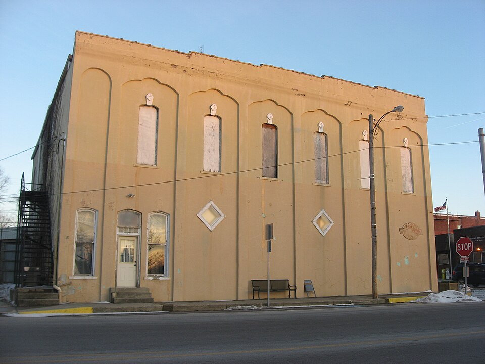
Photograph of Silver Lake Historic District
Photograph by Nyttend, Public domain. Via Wikimedia Commons.

Silver Lake Historic District

Listed on the National Register of Historic Places in 1992.

From the record

“Silver Lake Historic District is a national historic district located at Silver Lake, Indiana. The district encompasses 19 contributing buildings in the central business district and surrounding residential section of Silver Lake.”

Wikipedia article Silver Lake Historic District (Silver Lake, Indiana), CC BY-SA 4.0.

One of 17 National Register listings published here for Kosciusko County · listed in 1992 · category: District.

Sources: the Wikipedia article · the case file at the National Archives · the National Register database, National Park Service · the Wikipedia article

The listing

The ground it stands on

1,488 words

The chapter on Lake Township in Biographical and Historical Reocrd of Kosciusko County, published 1887 names Silver Lake. This is what it says, exactly as the scans read.

Henry B. Funk built and operated by steam a saw-mill on section -34 in 1848. The only lake of any importance in the township is Silver Lake, a beautiful body of water. It abounds with fish, but the sportsmen of the neighborhood allow it to remain practically undisturbed.

Passage source: Biographical and Historical Reocrd of Kosciusko County, published 1887.

Dr. Daniel E. Terry was one of the fii'st to practice his profession in Silver Lake, to which village he came in 1862. For a score of years he was the leading physician and since his removal to Rochester, his son Percy E. Terry has ably succeeded him. J. M. Amiss, M. D., is the other resident physician and is likewise a talented gentleman.

Passage source: Biographical and Historical Reocrd of Kosciusko County, published 1887.

Machine-read from a century-old scan, so expect the errors a machine makes: misspelled names, dropped words, stray characters.

Read the whole chapter on Lake Township - 1,488 words on its settlement, mills, schools and churches.

Storms near this property

11 since 2000

Regional context, not property-specific evidence. The National Weather Service names Silver Lake, the town this property stands in, in 11 storm reports between 2000 and 2017: 5 thunderstorm wind, 4 hail, 2 tornado. No death or injury is recorded in these reports. Each account below is quoted exactly as the forecast office filed it, from the NOAA Storm Events Database, and each date opens the federal record of that event.

WhenEvent Place namedHarm What the report says
November 2005Thunderstorm WindSilver Lake$1,000Trees were blown down across State Route 15.
May 2017Thunderstorm WindSilver Lake-Local fire officials reported several trees snapped or uprooted on properties along West County Road 950 South, between South 500 West and State Route 15. A few of these trees fell onto a residence, causing roof damage. Two barns suffered roof damage and a several spans of center pivot irrigation system were flipped. No injuries were reported.
July 2014Tornado (EF0)Silver Lake-A NWS Storm survey confirmed a tornado touched down in Wabash County and crossed into Kosciusko County east of County Road 100 West. One farm just inside the Kosciusko county border had a hog barn destroyed with much of the debris being thrown to the southeast into a large grain silo facility. One large grain bin was completely flattened and severe damage occurred to a harvester silo. In addition, a corn crop field to the south of the county line road and east of the farm was flattened and shredded. Additional extensive crop and tree damage continued before the tornado dissipated in a grove of trees just west of County Road 400 East. The total track of the tornado across both counties was around 7 miles with maximum winds of around 100 mph.
August 2013Thunderstorm WindSilver Lake-Local law enforcement officials reported numerous trees and tree limbs down.
November 2013Tornado (EF2)Silver Lake-A survey of damage in Wabash and Kosciusko counties by a NWS Survey team revealed that a tornado, which reached a maximum intensity of EF2, touched down just south of the Wabash/Kosciusko county line, west of State Route 15. The tornado crossed into Kosciusko county approximately 4 tenths of a mile east of State Route 15 and continued to the northeast over mainly open fields, occasionally causing tree damage until it hit a farm on CR 300 W approximately half a mile south of SR 14. At this location, there were 4 cattle barns completely destroyed with their contents thrown east-northeast into the field (DI:SBO DOD: 8). There were 600 cattle at the farm at the time the tornado hit and 10 of them were killed with another 10 injured. There was a two story home on this property that had part of the second story roof removed and the second story bedroom shifted as the east wall buckled outward. The debris field from this tornado continued to the NE and power poles were snapped at the base along SR 14. The tornado dissipated shortly after this as it crossed S County Farm Rd. The total path length across both counties was around 4.2 miles with a maximum estimated wind speed of 115 mph.
June 2009HailSilver Lake-An off duty NWS employee reported quarter size hail near Silver Lake.
May 2000Thunderstorm WindSilver Lake-Tree down.
May 2000Thunderstorm WindSilver Lake-Few trees down on power lines.
June 2008HailSilver Lake-no account filed
May 2004HailSilver Lake-no account filed
April 2000HailSilver Lake-no account filed

Every storm recorded in Kosciusko County

Map coverage status

No historic map-sheet match is published for this property yet. That does not mean no map exists. This record needs a coordinate-quality review before it can be joined to a sheet boundary. Browse the county's mapped places while that work is pending.

Sources for this property

National Archives recordThe nomination case file for reference 92001148 in Record Group 79.
Wikipedia articleCommunity-written account of this property, licensed CC BY-SA.
Kosciusko CountyAll 17 listed properties in this county.

Provenance

  • Listing record. National Park Service National Register of Historic Places, listed-properties dataset, current to 2026-05-22.
  • Map join. Address geocoded through the United States Census geocoder, then tested against the published boundary of every sheet in the USGS Historical Topographic Map Collection.
  • How this page is made. Listing fields come from federal records; map-sheet coverage is a labelled coordinate-to-boundary calculation, not a source-field claim.
  • Storms. NOAA National Centers for Environmental Information, Storm Events Database https://www.ncei.noaa.gov/stormevents/ A work of the United States government, no copyright under 17 U.S.C. 105. Narratives are quoted verbatim from the National Weather Service report and are not edited or summarised.