BlockBefore
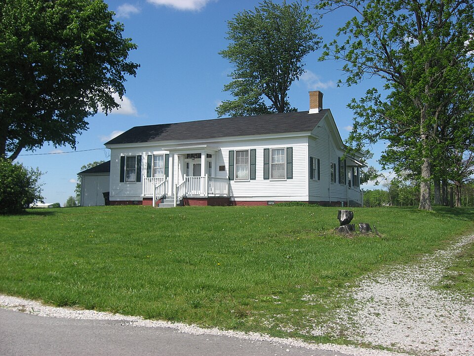
Photograph of McCormack-Bowman House
Photograph by Nyttend, Public domain. Via Wikimedia Commons.

McCormack-Bowman House

Listed on the National Register of Historic Places in 1995.

From the record

“McCormack-Bowman House is a historic home located in Franklin Township, Hendricks County, Indiana. It was built about 1846, and is a one-story, central passage plan, frame dwelling with Greek Revival style design elements.”

Wikipedia article McCormack-Bowman House, CC BY-SA 4.0.

One of 22 National Register listings published here for Hendricks County · listed in 1995 · category: Building.

Sources: the Wikipedia article · the case file at the National Archives · the National Register database, National Park Service


The listing

  • What is counted as historic. The nomination lists 1 building as contributing to the listing.
  • Listed as. McCormack--Bowman House - the National Register files a house under its owner's surname.
  • Address. Co. Rd. 200 W, 0.5 mi. S of jct. with US 40, Clayton, 46118
  • When was it listed? March 1995
  • Category. building
  • Township. Franklin township
  • Architectural style. Greek Revival architecture
  • National Register reference number. 95000200 - the number the National Park Service assigned this property when it was listed, and the key its nomination file is catalogued under at the National Archives.

The ground it stands on

7,970 words

This property stands in Franklin Township. History of Hendricks County, Indiana, Together with Sketches of Its Cities, Villages and Towns, Educational, Religious, Civil, Military, and Political History, Portraits of Prominent Persons, and Biographies of Representative Citizens, published 1885; History of Hendricks County, Indiana, Her People, Industries and Institutions, published 1914 gives that township a chapter of its own.

The chapter covers desckiption, eakly histoitt, fikst sceiools, township officials, fikst election, political history. ^pkopekty and taxation.

Machine-read from a century-old scan, so expect the errors a machine makes: misspelled names, dropped words, stray characters.

Read the whole chapter on Franklin Township - 7,970 words on its settlement, mills, schools and churches.

Storms near this property

16 since 1998

Regional context, not property-specific evidence. The National Weather Service names Clayton, the town this property stands in, in 16 storm reports between 1998 and 2023: 8 thunderstorm wind, 4 hail, 2 flash flood, 1 flood. No death or injury is recorded in these reports. Each account below is quoted exactly as the forecast office filed it, from the NOAA Storm Events Database, and each date opens the federal record of that event.

WhenEvent Place namedHarm What the report says
August 2016Tornado (EF1)Clayton$18,000An EF-1 tornado, with maximum winds estimated at 105 mph, caused minor damage to a few farm buildings, rolled a trailer, and uprooted trees.
June 1998Thunderstorm WindClayton$15,000no account filed
May 2016Thunderstorm WindClayton$4,000A large tree was downed covering the westbound lanes of Highway 40, south of Clayton, due to damaging thunderstorm wind gusts. Power lines were downed on both sides of the road.
December 2015Thunderstorm WindClayton$3,000A barn door was blown in near US Highway 40 and Highway 0 due to damaging thunderstorm wind gusts.
July 2015Flash FloodClayton$2,000Several roads were closed around the county because of flooding due to heavy thunderstorm rainfall. Also, White Lick Creek was about a foot out of its banks.
July 2015FloodClayton$1,000An estimated 4 inches of water was on the road at the intersection of State Route 39 and York Avenue due to moderate to heavy rainfall.
June 2018Thunderstorm WindClayton$250A 6-inch diameter tree limb was blown down at County Road 100 West and Highway 40 due to strong thunderstorm wind gusts.
June 2023HailClayton-Thunderstorm hail as large as ping pongs in Clayton.
June 2008Thunderstorm WindClayton-A three foot diameter tree was blown down in the roadway near a cemetery.
July 2008Thunderstorm WindClayton-A one-foot diameter tree was blown down by thunderstorm winds at County Road 200 West and United States Highway 40.
July 2005Thunderstorm WindClayton-Several large limbs were broken. A road was blocked by the debris.
July 2015HailClayton-no account filed
May 2014HailClayton-no account filed
July 2008Thunderstorm WindClayton-no account filed
May 2004HailClayton-no account filed
July 2003Flash FloodClayton-no account filed

Every storm recorded in Hendricks County

Map coverage status

No historic map-sheet match is published for this property yet. That does not mean no map exists. This record needs a coordinate-quality review before it can be joined to a sheet boundary. Browse the county's mapped places while that work is pending.

Listed places nearby

5 within 8 miles

Other National Register properties close enough to walk or drive between, ordered by distance from this one. Both positions come from the same geocoding pass that matched these properties to their map sheets.

Photograph PropertyDistance Listed
Amo THI & E Interurban Depot/Substation4.0 miles2007
Wilson-Courtney House7.6 miles1984
Hendricks County Jail and Sheriff's Residence8.0 miles1983
Twin Bridges8.0 miles2000
Danville Main Street Historic District8.0 miles1994

Sources for this property

National Archives recordThe nomination case file for reference 95000200 in Record Group 79.
Wikipedia articleCommunity-written account of this property, licensed CC BY-SA.
Hendricks CountyAll 22 listed properties in this county.

Provenance

  • Listing record. National Park Service National Register of Historic Places, listed-properties dataset, current to 2026-05-22.
  • Map join. Address geocoded through the United States Census geocoder, then tested against the published boundary of every sheet in the USGS Historical Topographic Map Collection.
  • How this page is made. Listing fields come from federal records; map-sheet coverage is a labelled coordinate-to-boundary calculation, not a source-field claim.
  • Storms. NOAA National Centers for Environmental Information, Storm Events Database https://www.ncei.noaa.gov/stormevents/ A work of the United States government, no copyright under 17 U.S.C. 105. Narratives are quoted verbatim from the National Weather Service report and are not edited or summarised.