
BlockBefore
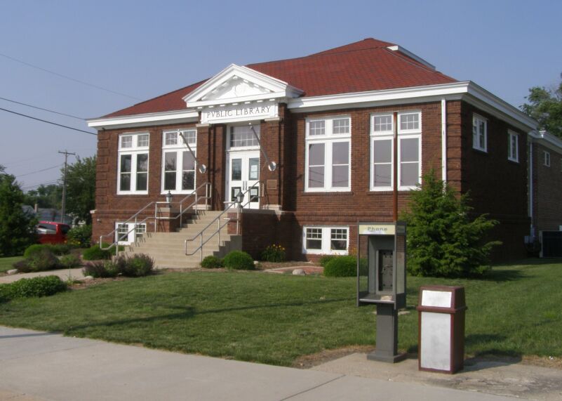
Photograph of Kirklin Public Library
Photograph by Chris Light, CC BY-SA 3.0. Via Wikimedia Commons.

Kirklin Public Library

Built in 1915 (Neoclassical architecture). Listed on the National Register of Historic Places in 1995.

From the record

“Kirklin Public Library is a historic Carnegie library located at Kirklin, Indiana. It was built in 1915, and is a one-story, Classical Revival style brick building on a raised basement.”

Wikipedia article Kirklin Public Library, CC BY-SA 4.0.

One of 12 National Register listings published here for Clinton County · listed in 1995 · category: Building · built in 1915, Neoclassical architecture.

Sources: the Wikipedia article · the case file at the National Archives · the National Register database, National Park Service

The listing

  • What is counted as historic. The nomination lists 1 building as contributing to the listing.
  • Address. 115 N. Main St., Kirklin, 46050
  • When was it listed? March 1995
  • Category. building
  • Township. Kirklin township
  • When was it built? 1915
  • Architectural style. Neoclassical architecture
  • National Register reference number. 95000206 - the number the National Park Service assigned this property when it was listed, and the key its nomination file is catalogued under at the National Archives.

The ground it stands on

1,439 words

The chapter on Kirklin Township in Combination Atlas Map of Clinton County, Indiana, published 1878 names Kirklin. This is what it says, exactly as the scans read.

In 1830, William Harris, of whom we have spoken in the history of Sugar Creek Township, moved to Kirklin Township, fixing his home on what is now the Charles Bridgeford farm. It being now generally known that a permanent settlement was being made in this locality, before the close of the year 1830, the following persons came and east their lot with the infant colony; Henry Percifield, on the Moses Gee farm; John Russell, on the farm owned by his daughter Jane; David Galbreath, on the farm belonging to Charles Bridgeford and John Foster; location unknown.

Passage source: Combination Atlas Map of Clinton County, Indiana, published 1878.

In 1832, Benjamin Bickley, father of C. H. Bickley, merchant of Kirklin, settled on the farm owned by the latter. Others of the same year were William Boils, on the Abraham Whittaker farm, and Adam Vincell, on the farm of Allen Williams.

Passage source: Combination Atlas Map of Clinton County, Indiana, published 1878.

Machine-read from a century-old scan, so expect the errors a machine makes: misspelled names, dropped words, stray characters.

Read the whole chapter on Kirklin Township - 1,439 words on its settlement, mills, schools and churches.

Storms near this property

8 since 1998

Regional context, not property-specific evidence. The National Weather Service names Kirklin, the town this property stands in, in 8 storm reports between 1998 and 2023: 6 thunderstorm wind, 1 flash flood, 1 hail. No death or injury is recorded in these reports. Each account below is quoted exactly as the forecast office filed it, from the NOAA Storm Events Database, and each date opens the federal record of that event.

WhenEvent Place namedHarm What the report says
November 2017Thunderstorm WindKirklin$5,000Roof damage was noted at State Road 421 and County Road 400 South due to damaging thunderstorm wind gusts. Pea sized hail was also noted at this location.
April 2013Thunderstorm WindKirklin$5,000Trees were reported down near County Road 1000 East due to damaging thunderstorm wind gusts.
May 2019Thunderstorm WindKirklin$2,000Multiple large, healthy tree limbs were downed across County Road 500 South due to damaging thunderstorm wind gusts.
June 2014Thunderstorm WindKirklin$1,500A tree was downed along with some utility lines due to damaging thunderstorm wind gusts.
August 2010Thunderstorm WindKirklin$1,000A two foot diameter tree was reported down due to damaging thunderstorm wind gusts.
June 2023HailKirklin-Thunderstorm hail caused damage to roof and siding of home in Kirklin.
July 2003Flash FloodKirklin-no account filed
December 1998Thunderstorm WindKirklin-no account filed

Every storm recorded in Clinton County

Map coverage status

No historic map-sheet match is published for this property yet. That does not mean no map exists. This record needs a coordinate-quality review before it can be joined to a sheet boundary. Browse the county's mapped places while that work is pending.

Sources for this property

National Archives recordThe nomination case file for reference 95000206 in Record Group 79.
Wikipedia articleCommunity-written account of this property, licensed CC BY-SA.
Clinton CountyAll 12 listed properties in this county.

Provenance

  • Listing record. National Park Service National Register of Historic Places, listed-properties dataset, current to 2026-05-22.
  • Map join. Address geocoded through the United States Census geocoder, then tested against the published boundary of every sheet in the USGS Historical Topographic Map Collection.
  • How this page is made. Listing fields come from federal records; map-sheet coverage is a labelled coordinate-to-boundary calculation, not a source-field claim.
  • Storms. NOAA National Centers for Environmental Information, Storm Events Database https://www.ncei.noaa.gov/stormevents/ A work of the United States government, no copyright under 17 U.S.C. 105. Narratives are quoted verbatim from the National Weather Service report and are not edited or summarised.