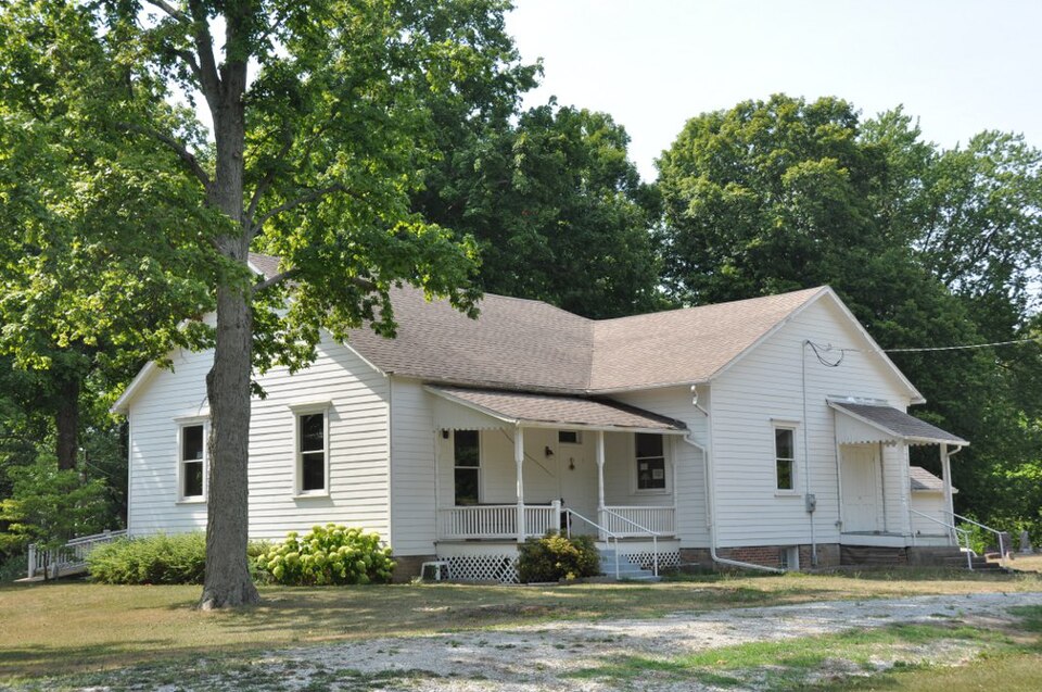
Built in 1857. Listed on the National Register of Historic Places in 1997.
From the record
“The Fall Creek Meeting House is a historic Quaker meeting house located approximately 3 miles (4.8 km) east of Pendleton, Indiana, United States, on State Road 38 in Fall Creek Township, Madison County, Indiana.”
Wikipedia article Fall Creek Meeting House, CC BY-SA 4.0.
One of 19 National Register listings published here for Madison County · listed in 1997 · category: Building · built in 1857.
National Register reference number.96001544- the number the National Park Service assigned this property when it was listed, and the key its nomination file is catalogued under at the National Archives.
Pendleton and Huntsvillc are both in this township. Among the first settlers of this township, commencing in 1820, were James Pendleton, Judge Winchell, Thomas Bell, Thomas and James Scott, Dr. Bordwell, Elias Hollingsworth, the Richmond family and Israel T. Cox. CJoming soon after were George Nicholson, Adam Dobson, Martin Chapman, William Williams, Enos Adamson, William and Thomas Silver, Isaac and John Busby, Palmer Patrick, J. T. Swain, B. F. Gregory, Judge AValker, William and James Brown, John H. and Ward Cook, A. M. Ulin, John J. Lewis and Neal Hardy.
Mr. H. was born in Philadelphia in the year 1803 ; came first to Indiana in 1832 ; returned, and came again in 1833. He came the first time all the way on foot ; on his arrival the second time he settled on his farm two and a half miles east of Pendleton, where he continued to live up to the time of his death, which occurred November the 16th, 1869. He was engaged for several years in the mercantile business in Pendleton, beginning in 1851. In 1861 he was elected to the oflSce of township trustee, in which capacity he served for a period of eight years, to the entire satisfaction of all. He was the first President, as well as a large stockholder in the Newcastle turnpike, in which enterprise he took a lively interest. In early life he was a Free Soiler, but in later life he acted with the Republican party. He was at Pendleton at the mobbing of Fred. Douglas, and took him under his roof for protection, afterward receiving a letter from Mr. D. thanking him for his unlimited kindness on that occasion. This letter will be published if it can be obtained. Mr. H. was a member of the Odd Fellows' lodge at Pendleton. He was the father of T. F. Hardy, of Markleville, and Morris Hardy, of Fall Creek, and Mrs. Lewis and Mrs. Boston, of Markleville. In person Mr. H. was of medium hight, was square and heavy made, goqd features, high forehead and dark eyes. He is buried at the Friends' graveyard, two and one-miles east of Pendleton.
Regional context, not property-specific
evidence. The
federal wildfire occurrence database
lists 7 fires within 5 miles of Fall Creek Meeting House
in 2004, burning about 3 acres in total. None started naturally. 1 was recorded as arson.
Distance is straight-line from the map coordinates, so a fire counted
here may appear on a neighbouring settlement's page as well.
Reported cause
Fires
Missing data/not specified/undetermined
2
Recreation and ceremony
2
Equipment and vehicle use
1
Arson/incendiarism
1
Debris and open burning
1
The most recent of
them, most recent first, with the day each was reported and the service
that recorded it.
Regional context, not property-specific
evidence. The federal mineral resources record lists
2 workings within 5 miles of Fall Creek Meeting House: 1 occurrence, 1 producer.
1 still produces. What was taken out: Zinc, Sulfur, Stone, Crushed/Broken. Distance is straight-line from the
map coordinates, so a quarry counted here may appear on a neighbouring
settlement's page as well.
Regional context, not property-specific
evidence. The National Weather Service names
Pendleton, the town this property stands in, in 24 storm reports between 1994 and 2026: 15 thunderstorm wind, 6 hail, 2 tornado, 1 lightning.
The reports record 5 injuries. Each account below is quoted exactly as the forecast office
filed it, from the NOAA Storm Events Database, and each date
opens the federal record of that event.
This damaging thunderstorm wind gust was estimated at 65 mph. Two 53-foot trailers were on their side. The driver and passenger of one semi truck with an attached 53-foot trailer on the side sustained minor injuries. Two port-o-lets were blown over. One fiberglass light pole was blown over as well.This occurred near 73rd Street and Layton Avenue.
NWS Indianapolis found tornado damage started west of Pendleton. The tornado moved through the north side of Pendleton toward Huntsville. In this area, mainly EF-1 damage was found, consisting of many trees blown down and minor roof damage.||Damage to structures in this part of the tornado path was caused primarily from trees falling onto homes and buildings. Saturated ground due to recent rains contributed to the numerous trees blown down.||The EF-2 tornado damage was found northeast of Huntsville. Three homes here suffered EF-2 damage which included roofs blown off two homes. A third home suffered damage when a part of an exterior brick wall collapsed inward to the home. The max wind speed was estimated at 130 mph. ||Thereafter, the tornado continued northeast, crossing Interstate 69 before lifting near 57th street and Main Street in Anderson.
A house was struck by lightning two miles northeast of Pendleton. No further information on property damage was given. The time and property damage of this event has been estimated.
No historic map-sheet match is published
for this property yet. That does not mean no map exists. This record needs
a coordinate-quality review before it can be joined to a sheet boundary.
Browse the county's mapped places while that work is
pending.
Listed places nearby
6 within 8 miles
Other National Register properties close
enough to walk or drive between, ordered by distance from this one. Both
positions come from the same geocoding pass that matched these properties
to their map sheets.
Listing record. National Park Service National Register of Historic Places, listed-properties dataset, current to 2026-05-22.
Map join. Address geocoded through the United States Census geocoder, then tested against the published boundary of every sheet in the USGS Historical Topographic Map Collection.
How this page is made. Listing fields come from federal records; map-sheet coverage is a labelled coordinate-to-boundary calculation, not a source-field claim.
Wildfire. Short, Karen C. 2022. Spatial wildfire occurrence data for the United States, 1992-2020 [FPA_FOD_20221014]. 6th Edition. Fort Collins, CO: Forest Service Research Data Archive. https://doi.org/10.2737/RDS-2013-0009.6 Collected with United States Government funding and usable without additional permissions or fees.
Mines and quarries. USGS Mineral Resources Data System (MRDS) https://mrdata.usgs.gov/mrds/ A work of the United States government, no copyright under 17 U.S.C. 105.
Storms. NOAA National Centers for Environmental Information, Storm Events Database https://www.ncei.noaa.gov/stormevents/ A work of the United States government, no copyright under 17 U.S.C. 105. Narratives are quoted verbatim from the National Weather Service report and are not edited or summarised.
 Block