 Block
From the record
14 National Register listings published here, 1 of them a National Historic Landmark.
Sources: the National Register database, National Park Service
72 topographic sheets cover 23 settlements here, and 14 properties are on the National Register of Historic Places.
14 National Register listings published here, 1 of them a National Historic Landmark.
Sources: the National Register database, National Park Service
Every property in this county listed on the National Register of Historic Places, with the year it was listed and the federal nomination document.
| Photograph | Property | Type | Listed | Reference |
|---|---|---|---|---|
| Claude and Alberta Brant House | building | 2022 | 100008241 | |
 | First Congregational Church | building | 2005 | 05000200 |
 | First Presbyterian Church | building | 2008 | 08000619 |
| Fort Scott Downtown Historic District | district | 2009 | 09001091 | |
 | Fort Scott National Cemetery | site | 1999 | 99000835 |
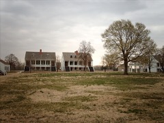 | Fort Scott National Historic Site | district | 1966 | 66000106 |
 | Fort Scott Public Carnegie Library | building | 1987 | 87000930 |
 | Fulton High School and Grade School | building | 2015 | 15000688 |
| Thomas L. and Anna B. Herbert House | building | 2021 | 100007280 | |
 | Long Shoals Bridge | structure | 1990 | 89002182 |
| Marmaton Bridge | structure | 1982 | 82002652 | |
 | Moody Building | building | 1977 | 77000570 |
 | Union Block | building | 1972 | 72000489 |
| Eugene Ware Elementary School | building | 2005 | 05000552 |
Every wildfire the federal occurrence database records inside this county: 284 of them, burning about 8,745 acres. None started naturally and 2 were recorded as arson. Each settlement page carries the fires within five miles of it.
| Reported cause | Fires |
|---|---|
| Debris and open burning | 95 |
| Smoking | 81 |
| Missing data/not specified/undetermined | 78 |
| Equipment and vehicle use | 13 |
| Recreation and ceremony | 8 |
| Power generation/transmission/distribution | 3 |
| Fireworks | 2 |
| Other causes | 2 |
| Arson/incendiarism | 2 |
The five largest, by the area the report gives. None of them was recorded as arson.
| Date | Cause | Size | Reported by | Name on the report |
|---|---|---|---|---|
| 3 October 2006 | Missing data/not specified/undetermined | 1,300 acres | Kansas Counties | GRAND |
| 23 August 2012 | Missing data/not specified/undetermined | 750 acres | Kansas Counties | YELLOWSTONE ROAD |
| 22 March 2018 | Debris and open burning | 400 acres | Kansas Forest Service | 110 |
| 16 January 2015 | Debris and open burning | 320 acres | Kansas Forest Service | 18 |
| 4 March 2018 | Debris and open burning | 300 acres | Kansas Forest Service | 58 |
| 11 March 2015 | Missing data/not specified/undetermined | 240 acres | Kansas Forest Service | 80 |
| 11 March 2015 | Smoking | 240 acres | Kansas Forest Service | 78 |
| 4 March 2018 | Debris and open burning | 240 acres | Kansas Forest Service | 57 |
Every settlement page carries the fires within five miles of it - see the settlement index below.
The NOAA Storm Events Database holds 452 reports for this county, causing no deaths, no injuries and about $37,176,500 in recorded property damage. Each settlement page carries the reports that name it.
| Kind of event | Reports |
|---|---|
| Hail | 173 |
| Thunderstorm Wind | 162 |
| Flash Flood | 71 |
| Tornado | 18 |
| Flood | 10 |
| Heavy Rain | 9 |
| Lightning | 5 |
| Funnel Cloud | 4 |
The most serious of them, by death, then injury, then recorded damage. The accounts are quoted exactly as the forecast office filed them.
| When | Event | Place named | Harm | What the report says |
|---|---|---|---|---|
| April 2013 | Hail | Ft Scott | $30,000,000 | Hen egg to tennis ball size hail was reported in Fort Scott, Kansas. It was estimated that two thirds of the homes in Fort Scott had damage because of hail. Windows to houses and cars were broken across the Fort Scott area. Damage was reported to siding and roofing of homes. The courthouse lost 66 windows as well as suffered damage to the roof, air conditioning and weather unit. One auto dealership had over a million dollar in damages to cars. The estimate damage cost for this storm for the entire county will be in this report. |
| July 2009 | Hail | Bronson | $2,000,000 | A supercell thunderstorm produced golf ball sized hail over the community of Bronson. Nearly every home in Bronson sustained window damage and siding damage from this wind driven large hail. |
| September 1998 | Flash Flood | Countywide | $1,000,000 | no account filed |
| April 2014 | Tornado (EF1) | Hammond | $500,000 | A storm survey conducted by the NWS Office in Pleasant Hill found an EF1 tornado began at the intersection of Highway 69 and Soldier Road, near Hammond, Kansas. Minor damage was noted near Hammond, with the most significant damage consisting of toppled over grain bins and several derailed empty train cars. Through the remainder of the Bourbon County path, several destroyed outbuildings were noted as well as significant tree damage. The tornado path continued into Linn County, Kansas. Maximum winds with the tornado in Bourbon County were estimated to be between 100 and 110 mph with a maximum width of 200 yards. |
| April 2023 | Thunderstorm Wind | Redfield | $350,000 | Numerous reports of significant wind damage to homes and outbuildings were received. At least one barn suffered structural failure and roof decking and shingles were removed from multiple homes and businesses. Several trees were also uprooted or damaged. Winds were estimated at between 80 - 90 mph. |
| March 2009 | Thunderstorm Wind | Devon | $300,000 | A National Weather Service storm survey revealed that straight line winds damaged rural areas north of Fort Scott. Damage included a two story home moved off of its foundation, two recreational vehicles overturned, a destroyed carport, tree damage, and several hay bales were flipped over. |
| June 1998 | Thunderstorm Wind | Countywide | $300,000 | no account filed |
| September 1973 | Tornado (F2) | not stated | $250,000 | no account filed |
| September 1973 | Tornado (F2) | not stated | $250,000 | no account filed |
| May 2020 | Thunderstorm Wind | Porterville | $200,000 | Thunderstorm winds downed numerous power poles and lines causing over 2000 power outages between Elsmore, Hiatville and Devon. |
| June 2008 | Thunderstorm Wind | Ft Scott | $200,000 | Nearly 200 trees were knocked over from thunderstorm wind gusts. Approximately 12 homes were damaged from these falling trees, while power lines were also impacted. Nearly 200 homes were without power on the west side of Fort Scott. |
| July 2009 | Thunderstorm Wind | Bronson | $150,000 | Severe thunderstorm wind damage, resulting from a bow echo, produced a swath of wind damage from one mile north of Bronson into the town of Bronson. Damage along this path included numerous power lines down, downed trees and large limbs, an overturned vehicle, significant window damage to many buildings and roof damage to homes and outbuildings. |
| July 2011 | Thunderstorm Wind | Marmaton | $130,000 | A micro burst caused damage to a car port, several out buildings, tore the roof off a small barn, destroyed a mobile home and caused roof damage to several other buildings. Several trees and power poles and a flag pole were downed. |
| July 2013 | Tornado (EF1) | Petersburg | $100,000 | A brief EF-1 tornado touched down near the southern end of the Bourbon County Lake and traveled northwestward towards the corner of 20th Street and Indian Road. One mobile home which was properly tied down was shifted approximately four feet off its foundation and had severe damage to the exterior. There was a couple outbuildings or small barns that were totally destroyed. There was a couple of trees that were uprooted. Numerous large tree branches were either blown down or snapped. Another house had numerous shingles torn off the roof. A pontoon boat was lifted and thrown 10 yards. The estimated winds were at 90 mph and path width of 100 yards. |
| March 2009 | Thunderstorm Wind | Redfield | $100,000 | A National Weather Service storm survey revealed that straight line winds damage rural areas southeast of Redfield. Damage consisted of signficant roof damage to homes and mobile homes. Numerous outbuildings were destroyed while trees were uprooted. |
| May 2009 | Tornado (EF1) | Bronson | $100,000 | A National Weather Service storm survey revealed that an EF-1 tornado impacted rural sections of western Bourbon County. The tornado damaged five large hay barns, several outbuildings, and uprtooted numerous trees. The wind speed was estimated at 90 mph. |
| October 2009 | Flash Flood | Ft Scott | $100,000 | Flash flooding lead to washouts and bridge damage to several roads across the county. |
| October 1998 | Flash Flood | Countywide | $100,000 | no account filed |
| April 2023 | Thunderstorm Wind | Edward | $75,000 | Emergency management reported wind damage to several roof tops, mainly removed or damages shingles, south of Fort Scott. |
| April 2010 | Thunderstorm Wind | Xenia | $75,000 | Thunderstorm winds damaged a modular home near Hidden Valley Lake. The home's roof was lifted off of the home and the western walls were pushed in. In addition, several trees were toppled taking down at least one power line. |
| April 2024 | Tornado (EF0) | Uniontown | $50,000 | A NWS storm survey determined that a weak EF-0 tornado occurred, with a path length of 3.12 miles and a width of 75 yards. Maximum wind speeds of 85 mph led to siding damage on a home, five outbuildings damaged or destroyed, and a number of trees either uprooted or having large limbs snapped. |
| May 2020 | Thunderstorm Wind | Ft Scott | $50,000 | Power lines and poles were down from winds estimated at 60 mph. |
| March 2017 | Thunderstorm Wind | Uniontown | $50,000 | Siding and shingles were blown off a few homes. A few homes had roof damage. A few outbuildings and detached garages were destroyed. This report was around the Uniontown area. |
| June 2008 | Thunderstorm Wind | Fulton | $50,000 | Severe thunderstorm wind gusts destroyed one barn and damaged a house along Highway 31. Tree damage also occurred in nearby areas. |
| June 2001 | Thunderstorm Wind | Ft Scott | $50,000 | no account filed |
| August 2019 | Thunderstorm Wind | Bronson | $35,000 | Numerous power lines and telephone poles was reported down across the western part of the county. |
| July 2009 | Thunderstorm Wind | Uniontown | $35,000 | Severe thunderstorm winds associated with a gust front, blowing from north to south, blew a tractor trailer over on Highway 54 west of Uniontown and downed several power lines in town. Highway 54 runs east to west and is perpendicular to the severe wind gust. |
| April 2024 | Hail | Fulton | $25,000 | Hail to the size of half dollars was reported. Some minor roof damage occurred. |
| July 2023 | Thunderstorm Wind | Uniontown | $25,000 | High winds were strong enough to roll round bales of hay and down several power lines. |
| July 2023 | Thunderstorm Wind | Ft Scott | $25,000 | A few power poles and power lines were reported down causing localized power outages. |
| July 2023 | Thunderstorm Wind | Ft Scott | $25,000 | Tree and power lines were down blocking several roads. |
| March 2017 | Thunderstorm Wind | Ft Scott | $25,000 | A NWS storm survey found that wind gusts estimated up to 90 mph damaged several businesses near the intersection of Highway 69 and 12th Street. Video from a dashcam on social media showed a roof blown off a gas station store and other structures nearby. Time was estimated by radar. |
| September 2014 | Thunderstorm Wind | Ft Scott | $25,000 | Several trees were reported down in Fort Scott. Some damage to vehicles were reported because of fallen trees and trees blocked several roadways. |
| April 1964 | Tornado (F1) | not stated | $25,000 | no account filed |
| June 1964 | Tornado (F1) | not stated | $25,000 | no account filed |
| March 1961 | Tornado (F2) | not stated | $25,000 | no account filed |
| May 2020 | Hail | Devon | $20,000 | Hail up to two inches in size damaged several vehicles and caused minor roof damage. |
| November 2018 | Thunderstorm Wind | Ft Scott Arpt | $15,000 | Thunderstorm winds broke three power poles and overturned a 33ft RV. Time based on radar. |
| September 2010 | Lightning | Ft Scott | $15,000 | Lightning struck the Bourbon County Courthouse which caused damage to the roof. There was also significant damage to electronics and computers inside the courthouse. |
| May 2002 | Thunderstorm Wind | Ft Scott | $15,000 | no account filed |
| May 2000 | Thunderstorm Wind | Ft Scott | $13,000 | no account filed |
| June 2021 | Thunderstorm Wind | Bronson | $10,000 | Several Highway signs were blown over. |
| November 2018 | Thunderstorm Wind | Pawnee Station | $10,000 | Thunderstorm winds damaged a barn near 160TH and Fern Road northwest of Pawnee Station. |
| September 2012 | Thunderstorm Wind | Redfield | $10,000 | Numerous trees and power poles along with power lines were blown down. |
| September 2012 | Thunderstorm Wind | Xenia | $10,000 | Numerous trees and power lines were reported down. |
| September 2012 | Thunderstorm Wind | Mapleton | $10,000 | Numerous trees, power lines, and poles were reported down. |
| July 2011 | Thunderstorm Wind | Garland | $10,000 | A power pole was snapped at its base, tree limbs up to 10 inches in diameter were downed, and a trailer home received minor roof damage. |
| June 2010 | Thunderstorm Wind | Ft Scott | $10,000 | Minor tree and home damage reported on the east side of town. |
| February 2009 | Thunderstorm Wind | Ft Scott | $10,000 | Severe thunderstorm wind gusts knocked over a semi truck. |
| June 2009 | Flash Flood | Garland | $10,000 | Excessive rainfall caused widespread flash flooding of roads across the county. Several roads had sections that were washed out. |
| July 2009 | Flash Flood | Fulton | $10,000 | Heavy rainfall, from training thunderstorms, produced flash flooding near the town of Fulton. The Emergency Manager reported that Yellowstone Road suffered severe damage due to swiftly flowing flood waters. Rainfall estimates from the training storms were around 3 to 4 inches. |
| August 2009 | Thunderstorm Wind | Ft Scott | $10,000 | Roof damage occurred to a mobile home and a barn along with downed trees and power lines. |
| July 2008 | Thunderstorm Wind | Ft Scott | $10,000 | Thunderstorm wind gusts knocked over several trees and power poles within the city of Fort Scott. |
| March 2008 | Thunderstorm Wind | Ft Scott | $10,000 | Winds from a severe thunderstorm damaged roofs and siding in Fort Scott. A tree was also reported to have been blown onto a home. |
| June 2008 | Thunderstorm Wind | Ft Scott | $10,000 | Roof damage occurred at St. Marys Catholic School as wind speeds in excess of 60 mph occurred. |
| December 2021 | Thunderstorm Wind | Ft Scott | $8,000 | Thunderstorm winds took shingles of a home and damaged the guttering. |
| September 2000 | Thunderstorm Wind | Ft Scott | $6,000 | no account filed |
| June 2025 | Hail | Bronson | $5,000 | Hail to two inches in diameter occurred in Bronson, Kansas. |
| June 2025 | Hail | Hammond | $5,000 | Hail to two inches in diameter occurred in Fort Scott, Kansas. |
| May 2024 | Thunderstorm Wind | Fulton | $5,000 | Social media report relaying that many trees were snapped halfway, with some being uprooted in Fulton, Kansas. |
The Survey's mineral resources record lists 3 workings inside this county. 2 still produce and 1 is closed or unrecorded. Each settlement page carries the workings within five miles of it.
| Commodity | Workings |
|---|---|
| Clay | 2 |
| Stone, Crushed/Broken | 1 |
The least common of them first, because a county's hundredth gravel pit says nothing its first ten did not.
| Where | Site | Commodity | Status | Recorded |
|---|---|---|---|---|
| Cullor Mine & Mill | Stone, Crushed/Broken | Producer | ||
| Ft. Scott Pottery Co. | Clay | Plant | ||
| Leslie Clay Pitt | Clay | Unknown |
Named settlements recorded in the Geographic Names Information System, each with the topographic sheets covering it. Villages, hamlets and abandoned places alike. Each is shown with the nearest named watercourse or landform and the survey quadrangle it falls on.
Timberhill township · 66754 · On Baker Branch · Mapleton quadrangle
14 sheets, 1887 to 1981
Marmaton township · 66769 · On Robinson Branch · Uniontown quadrangle
19 sheets, 1884 to 1991
Walnut township · 66779 · Moran SE quadrangle
17 sheets, 1886 to 1990
No longer a settlement
The vanished settlements of Bourbon County: the places named above that are no longer on the map.