 Block
From the record
3 National Register listings published here.
Sources: the National Register database, National Park Service
29 topographic sheets cover 7 settlements here, and 3 properties are on the National Register of Historic Places.
3 National Register listings published here.
Sources: the National Register database, National Park Service
Every property in this county listed on the National Register of Historic Places, with the year it was listed and the federal nomination document.
| Photograph | Property | Type | Listed | Reference |
|---|---|---|---|---|
 | Fromme-Birney Round Barn | building | 1987 | 87001253 |
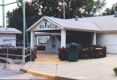 | Greensburg Well | structure | 1972 | 72000507 |
 | S.D. Robinett Building | building | 2009 | 09000029 |
Every wildfire the federal occurrence database records inside this county: 25 of them, burning about 59,911 acres. None started naturally and none was recorded as arson. Each settlement page carries the fires within five miles of it.
| Reported cause | Fires |
|---|---|
| Missing data/not specified/undetermined | 17 |
| Equipment and vehicle use | 6 |
| Debris and open burning | 2 |
The five largest, by the area the report gives. None of them was recorded as arson.
| Date | Cause | Size | Reported by | Name on the report |
|---|---|---|---|---|
| 7 April 1994 | Missing data/not specified/undetermined | 30,000 acres | Comanche County | not named |
| 16 March 1994 | Missing data/not specified/undetermined | 7,000 acres | Comanche County | not named |
| 18 February 1994 | Missing data/not specified/undetermined | 7,000 acres | Kiowa County | not named |
| 17 February 1997 | Missing data/not specified/undetermined | 6,000 acres | Comanche County | not named |
| 21 March 1997 | Missing data/not specified/undetermined | 5,000 acres | Kiowa County | not named |
| 5 April 2008 | Missing data/not specified/undetermined | 4,000 acres | Kansas Counties | KIOWA |
| 15 March 2018 | Missing data/not specified/undetermined | 450 acres | Kiowa County | COTTON BALE |
| 21 July 2012 | Missing data/not specified/undetermined | 420 acres | Kansas Counties | 2012019 GRASS |
Every settlement page carries the fires within five miles of it - see the settlement index below.
The NOAA Storm Events Database holds 629 reports for this county, causing 11 deaths, 74 injuries and about $255,120,730 in recorded property damage. Each settlement page carries the reports that name it.
| Kind of event | Reports |
|---|---|
| Hail | 396 |
| Thunderstorm Wind | 131 |
| Tornado | 64 |
| Heavy Rain | 28 |
| Flood | 5 |
| Flash Flood | 4 |
| Funnel Cloud | 1 |
The most serious of them, by death, then injury, then recorded damage. The accounts are quoted exactly as the forecast office filed them.
| When | Event | Place named | Harm | What the report says |
|---|---|---|---|---|
| May 2007 | Tornado (EF5) | Mullinville | 11 killed, 63 hurt, $250,000,000 | This killer tornado started in Comanche county and crossed into Kiowa county at 2003 CST / 2103 CDT. It curved north then northwest before making a complete loop northwest of Greensburg. Thus, the path was 25.8 miles.||This tornado destroyed nearly 95 percent of the town of Greensburg and despite adequate warning, unfortunately took the life of 11 people, some that were in basements. First responders arriving on the scene requested three refrigerated refer trucks thinking there would be hundreds of fatalities. It also destroyed a dozen homes and a church south of Greensburg but did not cause injury. In all, 961 homes and businesses were destroyed, 216 received major damage and 307 received minor damage. ||As the tornado was dissipating it turned northwest, west, south and then back east making a loop. This was documented on both high resolution doppler radar and through the ground survey. Also as the tornado was dissipating a new circulation quickly grew northeast of town.||Several oil storage tanks were destroyed causing an environmental concern. In the town of Greensburg, hazardous material was strewn everywhere. As of July 26th, the debris was still not fully cleaned up. Two landfills were filled with debris from the town and this was even as most was burned. Hundreds of thousands of dump truck loads were taken out. It was estimated that approximately 400,000 cubic yards of debris was removed. The major highway running through town was closed for 1 full month.||At one time there were over 150 law enforcement officers (from all over the country) present. Military was called in for debris removal and rebuilding. ||Damage of insured losses exceeded $150 million, but including un-insured losses, was roughly 250 million dollars.||**** NOTE **** The 11th victim passed away on September 19th, 2007 after a long battle with a head injury sustained during the tornado. |
| April 1956 | Tornado (F4) | not stated | 6 hurt, $250,000 | no account filed |
| August 1986 | Tornado (F1) | not stated | 3 hurt, $25,000 | no account filed |
| May 2002 | Tornado (F3) | Mullinville | 1 hurt, $800,000 | This tornado moved slowly east/northeast at first and then turned south/southeast striking two farms. One person was thrown from the house and into the yard. |
| June 1958 | Tornado (F1) | not stated | 1 hurt, $2,500 | no account filed |
| August 1996 | Thunderstorm Wind | Haviland | $2,000,000 | no account filed |
| June 1996 | Thunderstorm Wind | Mullinville | $1,500,000 | no account filed |
| March 2021 | Thunderstorm Wind | Haviland | $100,000 | There were several pivot irrigations systems rolled over several times and were completely destroyed. An unofficial wind measurement from a home weather station was 114 MPH. |
| July 1999 | Thunderstorm Wind | Greensburg | $70,000 | Pivot sprinkler overturned...siding stripped off a house and a shed was destroyed. |
| April 2006 | Thunderstorm Wind | Haviland | $50,000 | A pivot irrigation sprinkler was overturned by the high wind. |
| May 2002 | Thunderstorm Wind | Haviland | $50,000 | A tractor was blown upside down onto a road. |
| June 1994 | Thunderstorm Wind | Greensburg | $50,000 | no account filed |
| April 2001 | Thunderstorm Wind | Haviland | $40,000 | 100 year old cedar tree was uprooted. |
| July 1999 | Thunderstorm Wind | Greensburg | $30,000 | All out buildings destroyed. |
| March 1992 | Tornado (F1) | not stated | $25,000 | no account filed |
| May 1965 | Tornado | not stated | $25,000 | no account filed |
| May 1962 | Tornado (F2) | not stated | $25,000 | no account filed |
| March 2021 | Thunderstorm Wind | Mullinville | $20,000 | Roof damage and broken windows resulted from the high wind. A nearby weather station reported a gust to 105 MPH. |
| June 2013 | Tornado (EF1) | Mullinville | $18,000 | A detached garage was destroyed and thrown northwest by a small tornado that developed on the leading edge of the squall line. |
| July 2000 | Thunderstorm Wind | Greensburg | $10,000 | Barn destroyed and trees uprooted. |
| March 2000 | Thunderstorm Wind | Greensburg | $8,000 | Downburst removed a tin roof off a building and damaged part of the wall. |
| July 2025 | Flash Flood | Mullinville | $5,000 | The Emergency management reported roads washed out in southwest Kiowa County. Time estimated. |
| April 2001 | Thunderstorm Wind | Greensburg | $5,000 | Roof blown off a modular home under construction |
| May 1995 | Thunderstorm Wind | 2 E Greensburg | $5,000 | Damage to siding from 90 mph wind and dime-size hail. |
| May 1975 | Tornado (F1) | not stated | $2,500 | no account filed |
| May 2002 | Thunderstorm Wind | Greensburg | $2,000 | Four power poles were blown down. |
| July 1999 | Thunderstorm Wind | Greensburg | $1,500 | Power poles blown down. |
| May 2002 | Thunderstorm Wind | Wellsford | $500 | Vehicle blown into a ditch. |
| August 2002 | Thunderstorm Wind | Mullinville | $500 | Heavy farm machinery was moved by the high wind. |
| March 2000 | Thunderstorm Wind | Mullinville | $200 | Trampoline was thrown into trees. |
| August 1960 | Tornado (F0) | not stated | $30 | no account filed |
| May 2025 | Tornado (EF3) | Greensburg | - | A NWS storm survey confirmed reports of a tornado. Some damage included broken power poles, tree trunk snaped, an irrigation pivot broken and tossed. |
| September 2025 | Thunderstorm Wind | Wellsford | - | There was a snapped utility pole reported. |
| August 2025 | Thunderstorm Wind | Mullinville | - | The Mesonet station UP372 2.3 W Mullinville reported a 66 mph wind gust. |
| August 2025 | Thunderstorm Wind | Greensburg | - | A personal weather station, Kents station, recorded a 71 mph wind gust. |
| August 2025 | Thunderstorm Wind | Greensburg Arpt | - | Mesonet station UP323 2.3 E Greensburg (UPR) recorded a 58 mph wind gust. |
| May 2025 | Tornado (EF3) | Brenham | - | A NWS storm survey confirmed reports of a tornado with damage including snapped power poles, debarked trees, tossed irrigation pivots, and other damage. |
| May 2025 | Tornado (EF1) | Brenham | - | Short-lived satellite tornado off of the larger main votex farther east. Total path just under 3 miles and width no more than 50 yards with peak winds of 90 mph. |
| September 2025 | Hail | Greensburg | - | A storm chaser reported 1 inch hail. |
| June 2024 | Flash Flood | Mullinville | - | Road over highway. |
| June 2024 | Thunderstorm Wind | Greensburg | - | A 65 mph wind gust was reported. |
| May 2024 | Heavy Rain | Haviland | - | A 24 hour rainfall report of 1.00 inches. |
| May 2024 | Heavy Rain | Greensburg | - | Rainfall report of 2.39 inches. |
| May 2024 | Heavy Rain | Mullinville | - | Rainfall report of 2.54 inches. |
| May 2024 | Heavy Rain | Brenham | - | Rainfall report of 1.80 inches. |
| August 2022 | Thunderstorm Wind | Greensburg | - | There was significant tree damage. |
| June 2022 | Thunderstorm Wind | Haviland | - | A semi truck was blown over on the highway. |
| March 2021 | Thunderstorm Wind | Joy | - | Numerous windows were blown out by high wind. |
| March 2021 | Thunderstorm Wind | Greensburg | - | There was roof damage. |
| March 2021 | Thunderstorm Wind | Mullinville | - | Numerous windows were blown out by the high wind. |
| March 2021 | Thunderstorm Wind | Greensburg | - | There was single damage to a roof. |
| October 2021 | Thunderstorm Wind | Greensburg Arpt | - | Winds were estimated to be 70-80 MPH wind gusts. |
| October 2021 | Tornado (EF1) | Joy | - | This was a qlcs tornado. |
| October 2021 | Tornado (EFU) | Joy | - | This was a qlcs tornado. |
| July 2020 | Heavy Rain | Haviland | - | Rainfall of 2.00 inches was observed. |
| June 2019 | Thunderstorm Wind | Greensburg | - | Winds were estimated to be 70 MPH. One to two inch diameter tree branches were broken by the high wind. |
| May 2019 | Thunderstorm Wind | Mullinville | - | Winds were estimated to be gusting to 70 MPH. |
| September 2019 | Heavy Rain | Joy | - | Rainfall of 4.43 inches was observed. |
| September 2019 | Hail | Greensburg | - | Mostly dime sized hail was observed but a few the size of a quarter were noted. |
| August 2019 | Heavy Rain | Haviland | - | Rainfall of 2.40 inches was observed. |
Named settlements recorded in the Geographic Names Information System, each with the topographic sheets covering it. Villages, hamlets and abandoned places alike. Each is shown with the nearest named watercourse or landform and the survey quadrangle it falls on.
Kiowa Rural township · 67028 · On Spring Creek · Belvidere quadrangle
13 sheets, 1892 to 1985