 Block
From the record
11 National Register listings published here.
Sources: the National Register database, National Park Service
41 topographic sheets cover 22 settlements here, and 11 properties are on the National Register of Historic Places.
11 National Register listings published here.
Sources: the National Register database, National Park Service
Every property in this county listed on the National Register of Historic Places, with the year it was listed and the federal nomination document.
| Photograph | Property | Type | Listed | Reference |
|---|---|---|---|---|
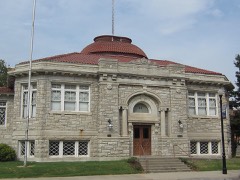 | Carnegie Library | building | 1976 | 76000824 |
| First State Bank | building | 1982 | 82000417 | |
| Labette Creek Tributary Bridge | structure | 1985 | 85001431 | |
| Oakwood Cemetery | site | 2024 | 100010344 | |
 | Oswego Public Carnegie Library | building | 1987 | 87000956 |
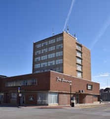 | Parsonian Hotel, The | building | 2015 | 15000145 |
| Parsons Filled Arch Bridge | structure | 1985 | 85001436 | |
| Parsons Katy Hospital | building | 2008 | 07001482 | |
| Pumpkin Creek Tributary Bridge | structure | 1985 | 85001439 | |
| Riverside Park | district | 2012 | 12000412 | |
| US Post Office-Oswego | building | 1989 | 89001648 |
Every wildfire the federal occurrence database records inside this county: 137 of them, burning about 1,085 acres. None started naturally and 11 were recorded as arson. Each settlement page carries the fires within five miles of it.
| Reported cause | Fires |
|---|---|
| Missing data/not specified/undetermined | 67 |
| Debris and open burning | 45 |
| Arson/incendiarism | 11 |
| Equipment and vehicle use | 10 |
| Smoking | 3 |
| Recreation and ceremony | 1 |
The five largest, by the area the report gives. None of them was recorded as arson.
| Date | Cause | Size | Reported by | Name on the report |
|---|---|---|---|---|
| 25 January 2018 | Missing data/not specified/undetermined | 300 acres | Kansas Forest Service | 15 |
| 2 March 2017 | Missing data/not specified/undetermined | 250 acres | Labette County | 1700011 |
| 2 March 2017 | Debris and open burning | 60 acres | Labette County | 1700010 |
| 11 April 2018 | Missing data/not specified/undetermined | 40 acres | Kansas Forest Service | 42 |
| 30 March 2015 | Debris and open burning | 30 acres | Kansas Forest Service | 6 |
| 9 February 2017 | Debris and open burning | 28 acres | Labette County | 17006 |
| 19 February 2017 | Debris and open burning | 20 acres | Labette County | 170011 |
| 9 July 2018 | Missing data/not specified/undetermined | 20 acres | Kansas Forest Service | 180034 |
Every settlement page carries the fires within five miles of it - see the settlement index below.
The NOAA Storm Events Database holds 604 reports for this county, causing 3 deaths, 44 injuries and about $83,881,050 in recorded property damage. Each settlement page carries the reports that name it.
| Kind of event | Reports |
|---|---|
| Hail | 233 |
| Thunderstorm Wind | 230 |
| Tornado | 43 |
| Flash Flood | 40 |
| Flood | 26 |
| Heavy Rain | 23 |
| Lightning | 6 |
| Funnel Cloud | 3 |
The most serious of them, by death, then injury, then recorded damage. The accounts are quoted exactly as the forecast office filed them.
| When | Event | Place named | Harm | What the report says |
|---|---|---|---|---|
| April 2009 | Flood | Parsons Tri City Arp | 2 killed, $500,000 | Continued runoff from a couple heavy rainfall episodes from the 26th through the 30th produced areal flooding across portions of Labette county, as well as river flooding along the Neosho River, and its associated tributaries. Several rural and some city roads were closed due to high water. Trailer homes along the Neosho River on Highway 400 near Parsons were partially submerged. Flooding extended into the evening hours of May 4th. Sadly, two people were killed sometime during the overnight hours of the 27th or the early morning hours of the 28th, after attempting to traverse a flooded low water bridge crossing in their vehicle due to the swollen Pumpkin Creek just east of Mound Valley on 15000 Road. The strong current swept their vehicle 200 feet downstream, likely trapping the two victims. The vehicle was found overturned and submerged in about 10 feet of water. Unfortunately, total property and crop damage estimates are unknown. The Independence Daily Reporter, Parsons Sun, and Coffeyville Journal, contributed to this report. |
| September 1959 | Tornado (F4) | not stated | 1 killed, 1 hurt, $25,000 | no account filed |
| April 2000 | Tornado (F3) | Dennis | 27 hurt, $71,000,000 | The same tornado that formed 3 miles south of Cherryvale at 1930 CST in eastern Montgomery County, the tornado entered western Labette County at 1934 CST, 10 miles southwest of Dennis. Moving northeast around 35 mph, the tornado passed 4 miles south of Dennis at 1940 CST. At 1945 CST, the tornado entered southwest Parsons where it inflicted major damage to a law enforcement center, a movie theater, and a carnival. In all, 750 buildings were damaged of which 633 were homes. Of the homes, 53 were destroyed, 112 sustained major damage and 468 received minor damage. Of the 117 commercial buildings that sustained damage, 20 were destroyed, 28 received major damage, and 69 received minor damage. Total damage estimate: $40 million. A total of 27 people were injured, most were minor. Though inflicting F3 damage when it hit Parsons, the tornado possessed F1 intensity for most of it's track. This same tornado would continue moving northeast, clipping southeast Neosho County. Area newspapers contributed to this report. |
| April 2006 | Tornado (F1) | Chetopa | 12 hurt, $225,000 | An F1 tornado entered Labette County from Oklahoma near Victory road about 3 miles southwest of Chetopa. The tornado tracked to the east-northeast where it struck 2 homes and a mobile home. The mobile home was destroyed and the 2 other homes were damaged. Twelve minor injuries occurred when the tornado damaged the homes and destroyed the mobile home south of Chetopa. The tornado also flipped a tractor trailer on highway 59. The tornado exited Labette County about 1 mile south of highway 166 and moved into Crawford County. |
| February 2012 | Thunderstorm Wind | Altamont | 3 hurt, $250,000 | Winds estimated between 90 and 110 mph produced widespread damage across Labette county, including damage to sheds, mobile homes, trees and power lines. The most extensive damage occurred in a three-mile-wide swath roughly 5 to 8 miles south of Parsons, including an overturned and completely destroyed mobile home. County officials estimated that roughly 15 to 18 homes were damaged countywide. Westar reported 25 utility poles downed countywide, resulting in nearly 80 percent of the county without power. Three injuries (direct) were reported across the county, one of which was critical. Property damage amounts are rough estimates. The Wichita Eagle and Parsons Sun contributed to this report. |
| May 2003 | Tornado (F1) | Bartlett | 1 hurt, $2,500,000 | In Bartlett, the following were either heavily damaged or destroyed: 24 farm dwellings and service buildings, and 40 pieces of farm machinery and equipment. |
| March 1982 | Tornado (F3) | not stated | $2,500,000 | no account filed |
| March 1982 | Tornado (F2) | not stated | $2,500,000 | no account filed |
| July 2004 | Thunderstorm Wind | Oswego | $1,000,000 | Barn sustained minor roof damage with trees uprooted in it's immediate vicinity. (Narrative courtesy of Parsons Sun.) Approximately 180 homes damaged, the magnitude ranging from minor to a few that were considered "totaled" by insurance adjustors. The following town property sustained damage: The golf course club house, the roofs of an unspecified number of buildings, fencing at the summer ball field, the electrical circuitry at Riverside Park, and the former Tee Top building. Governor Sebelius declared Labette County a disaster area. (Latter portion of narrative courtesy of Oswego Independent Observer.) |
| July 2007 | Flash Flood | Parsons | $540,000 | Extremely heavy rainfall from the end of June into early July caused flash flooding throughout Labette County. The flash flooding and the ensuing river flooding resulted in 2 homes being destroyed and 11 others suffering major damage. This resulted in roughly 540 thousand dollars in damage. Major flooding was observed at Parsons and Oswego. Parsons recorded a crest of 35.05 feet while Oswego recorded a crest of 30.0 feet. These crests were 14.05 feet and 13 feet above flood stage respectively. The Neosho fell blow flood stage on the July 7th at both locations. |
| May 2007 | Flash Flood | Parsons | $350,000 | A car trying to get away from flood water was swept off a road leading to a water rescue. |
| August 2009 | Thunderstorm Wind | Parsons | $250,000 | Several trees, limbs and power lines were downed in the Parsons area. Some of the downed power lines caused fires, but they were extinguished fairly rapidly. Property damage was limited mainly to trees and limbs falling on homes and other structures. Roof damage occurred to a handful of structures from winds peeling back a portion of the roof. Substantial water damage occurred inside at least one of the structures due to rain falling onto a heavily damaged roof. The Parsons Sun contributed to this report. |
| April 1996 | Thunderstorm Wind | Chetopa | $250,000 | no account filed |
| March 1990 | Tornado (F1) | not stated | $250,000 | no account filed |
| May 2009 | Thunderstorm Wind | Parsons | $180,000 | Several large trees were knocked all over town as thunderstorm winds estimated at 80 mph moved through the area. The storms also knocked down 20 power poles all over town. The strong winds also caused minor roof damage to numerous businesses. The trees and debris fell on houses and cars throughout the town. |
| September 2001 | Thunderstorm Wind | Oswego | $150,000 | Machine shed destroyed. Time estimated. |
| September 2014 | Thunderstorm Wind | Parsons | $120,000 | Several trees, limbs and power lines were knocked down from Big Hill Lake, Mound Valley and Parsons. |
| August 2009 | Lightning | Bartlett | $100,000 | Lightning struck a fertilizer plant in downtown Bartlett during the early morning hours on the 20th. Consequently, a large fire erupted, engulfing and eventually destroying the entire plant. No one was injured. Property damage amounts are rough estimates. The Labette Avenue contributed to this report. |
| April 2007 | Thunderstorm Wind | Edna | $100,000 | An untied and empty silo was blown over, three barns were completely destroyed, and a grove of cedar trees was snapped in half. |
| March 2002 | Thunderstorm Wind | Altamont | $100,000 | Extensive damage at a farm. Damage summary: Machine shed lifted off foundation and destroyed with all machinary stored inside strewn. Machine shed blew into neighbor's yard, hitting two barns. Of the two barns, one was unroofed while the second lost nearly half it's roof. Numerous shingles were torn off the house. Gates to a third barn were blown down. Pool damaged. |
| April 2016 | Thunderstorm Wind | Parsons | $50,000 | There was unspecified structural damage to a building at the Highway 400/Wallace Rd. Intersection. Power outages were reported across much of Northern Labette County. |
| June 1999 | Thunderstorm Wind | Parsons | $50,000 | Substantial damage sustained to hangar as well as damage to rear landing gear and tail section of a Cessna 170 housed inside. |
| September 1993 | Thunderstorm Wind | Dennis | $50,000 | no account filed |
| May 2009 | Thunderstorm Wind | Altamont | $40,000 | Numerous trees and power poles were knocked down by winds estimated at 80 mph. Outbuildings were damaged by falling trees throughout town. |
| April 1999 | Lightning | Parsons | $35,000 | Lightning struck a single-story, woodframed house, setting it afire. Though the house was a total loss, no one was injured. The lightning strike also damaged an apartment located directly behind the house. |
| May 2009 | Thunderstorm Wind | Chetopa | $30,000 | Numerous trees were knocked down across town from winds estimated at 60 mph. Some of the trees fell on outbuildings and vehicles damaging them. |
| May 2009 | Thunderstorm Wind | Oswego | $30,000 | Numerous trees were knocked down across town as winds estimated around 60 mph moved across the area. The trees fell on outbuildings and vehicles causing damage. |
| August 2003 | Thunderstorm Wind | Oswego | $25,000 | Power lines downed and a few large trees uprooted. |
| March 2003 | Tornado (F1) | Dennis | $25,000 | The following was damaged/destroyed: Two grain bins overturned, one carport destroyed, and a few road signs damaged. |
| July 2003 | Thunderstorm Wind | Parsons | $25,000 | Downed limbs, some of which entangled with power lines, resulted in power outages. The Parsons Sun contributed to this narrative. |
| May 2002 | Thunderstorm Wind | Chetopa | $25,000 | Barn destroyed. |
| July 2002 | Thunderstorm Wind | Mound Vly | $25,000 | Two power poles snapped and three trees fell onto power lines severing power to just over 400 residences of which about 300 were in Mound Valley. |
| August 2002 | Lightning | Parsons | $25,000 | Initially striking the roof, the lightning traveled down a bedroom wall then "jumped" to another room. South end of attic heavily damaged, the bulk of which was to insulation. |
| August 2001 | Thunderstorm Wind | Dennis | $25,000 | Power lines downed. |
| September 2001 | Thunderstorm Wind | Parsons | $25,000 | Widespread tree and power line damage, including a few trees that were uprooted, one of which fell onto a house. Area newspapers contributed to this report. |
| October 2001 | Thunderstorm Wind | Chetopa | $25,000 | Numerous trees uprooted and fell onto power lines with a couple power poles cracked or broken in the process. The resulting power outage, which affected the entire town, lasted about one hour. Time is estimated based on arrival time of thunderstorms into northward-neighboring Neosho County. |
| October 2001 | Thunderstorm Wind | Parsons | $25,000 | Downed limbs onto power lines resulted in power outages to approximately 500 residences, of which 81 were still without power the following morning. Time is estimated based on arrival of thunderstorms into northward-neighboring Neosho County. |
| February 2000 | Thunderstorm Wind | Bartlett | $25,000 | Estimated 70 mph winds lifted sections of a barn roof, twisted and mangled several hedge trees and broke numerous 8-10 inch diameter tree limbs. |
| May 2000 | Thunderstorm Wind | Parsons | $25,000 | The following property was damaged: Siding was ripped from a house, metal roofing was ripped from the tops of two small businesses, a temporary wall at a building supply proved to be just that as it was blown down, and a sign that had been set with 4-inch metal pipes was bent over. In addtion, damage to trees and power lines was widespread. |
| May 1999 | Thunderstorm Wind | Dennis | $25,000 | Roof was torn off a metal barn. |
| May 1966 | Tornado | not stated | $25,000 | no account filed |
| April 1964 | Tornado (F1) | not stated | $25,000 | no account filed |
| May 1958 | Tornado (F3) | not stated | $25,000 | no account filed |
| June 2010 | Thunderstorm Wind | Parsons | $21,000 | Two windows were blown out and a portion of the roof was peeled back at a radio station and sporting goods store in downtown. The resulting rain from the open roof and windows soaked the radio equipment at the radio station and soaked half the inventory of the store. The equipment damage kept two radio staitons off the air over the weekend. A very large tree also fell on a house. 1100 residents were without power for awhile. |
| March 2017 | Thunderstorm Wind | Labette | $20,000 | A house had a partially collapsed roof, with the roof blown off of a machine shed. Also, numerous trees were reported down. |
| August 2003 | Lightning | Parsons | $20,000 | Unspecified number of power poles struck, severing power to 586 residences. By approximately 10 AM the following morning, power had been restored to all but 20 residences. Times of incidents are approximate. Narrative courtesy of Parsons Sun. |
| March 2002 | Thunderstorm Wind | Altamont | $20,000 | Roof and rafters of shed lifted intact and blown 30-50 yards east of shed's location. Minor damage to outbuildings. A few limbs greater than 2 inches in diameter downed. |
| September 2001 | Thunderstorm Wind | Oswego | $20,000 | Trees, power lines and power poles downed. |
| September 2010 | Thunderstorm Wind | Parsons | $15,000 | Widespread tree damage was reported across town. Some damage occurred to the Emergency Operations Center in Parsons. |
| April 2007 | Thunderstorm Wind | Chetopa | $15,000 | A few small outbuildings were damaged, and a few power poles were downed. |
| April 2004 | Thunderstorm Wind | Altamont | $15,000 | Downed power lines and power poles severed power to approximately 300 residents around 2000 CST. (Narrative courtesy of Parsons Sun.) |
| May 2002 | Thunderstorm Wind | Edna | $15,000 | House sustained minor roof damage. Portable carport blown into trees. Mailbox blown acorss road. Minor tree damage. |
| May 2002 | Thunderstorm Wind | Chetopa | $15,000 | Stand alone garage collapsed onto new truck. |
| September 2009 | Flash Flood | Parsons | $10,000 | Over four inches of rainfall caused several roads to be flooded or barricaded across the city including 12th Street, 13th Street, Crawford and North Lincoln Street. |
| August 2003 | Thunderstorm Wind | Chetopa | $10,000 | Power lines and power poles downed. The most significant: A power pole containing a transformer. (Parsons Sun.) |
| September 2001 | Thunderstorm Wind | Bartlett | $10,000 | Trees and power lines downed. |
| June 1998 | Thunderstorm Wind | Dennis | $10,000 | Back porch lost half of it's roof. |
| February 2009 | Thunderstorm Wind | Parsons | $8,000 | The visitors dugout at Ray Bennett sofball field was destroyed by a thunderstorm wind gust along with a portion of the outfield fence. |
| May 2010 | Lightning | Altamont | $7,000 | During the late evening hours on the 19th, lightning from a relatively weak area of showers and thunderstorms struck a farmstead northwest of Altamont in Labette County. Several small outbuildings were set ablaze. No injuries were incurred, but several small outbuildings were deemed a total loss. The Parsons Sun contributed to this report. |
| November 2021 | Thunderstorm Wind | Chetopa | $5,000 | Tree limbs and a couple of road signs were blown down. |
The Survey's mineral resources record lists 3 workings inside this county. 2 still produce and 1 is closed or unrecorded. Each settlement page carries the workings within five miles of it.
| Commodity | Workings |
|---|---|
| Stone, Crushed/Broken | 2 |
| Lead, Zinc | 1 |
The least common of them first, because a county's hundredth gravel pit says nothing its first ten did not.
| Where | Site | Commodity | Status | Recorded |
|---|---|---|---|---|
| Oswego Mine | Lead, Zinc | Prospect | 1968 | |
| Chetopa Quarry | Stone, Crushed/Broken | Producer | ||
| Parsons Quarry & Mill No.3 | Stone, Crushed/Broken | Producer |
Named settlements recorded in the Geographic Names Information System, each with the topographic sheets covering it. Villages, hamlets and abandoned places alike. Each is shown with the nearest named watercourse or landform and the survey quadrangle it falls on.
Neosho township · 67357 · On Hickory Creek · Parsons East quadrangle
18 sheets, 1886 to 1990
Mound Valley township · 67354 · On Lost Branch · Mound Valley quadrangle
18 sheets, 1886 to 1990
Parsons city · 67357 · On Tolen Creek · Parsons West quadrangle
19 sheets, 1886 to 1990