
BlockBefore
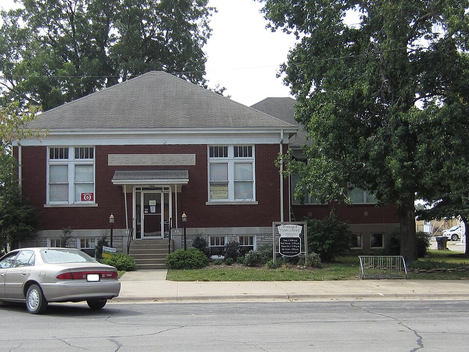
Photograph of Oswego Public Library
Photograph by Kaethesson, CC BY-SA 3.0. Via Wikimedia Commons.

Oswego Public Carnegie Library

Built in 1912 (Neoclassical architecture). Listed on the National Register of Historic Places in 1987.

From the record

“Oswego Public Library (OPL) is a Carnegie Library located in Oswego, Kansas, United States. It is a member of the Southeast Kansas Library System, a consortium of over 100 independent libraries in Southeast Kansas that provides services to member libraries such as inter-library loan.”

Wikipedia article Oswego Public Library, CC BY-SA 4.0.

One of 11 National Register listings published here for Labette County · listed in 1987 · category: Building · built in 1912, Neoclassical architecture.

Sources: the Wikipedia article · the National Register database, National Park Service

The listing

  • What is counted as historic. The nomination lists 1 building as contributing to the listing.
  • Address. 704 Fourth St., Oswego, 67356
  • When was it listed? June 1987
  • Category. building
  • Also known as. Carnegie Libraries of Kansas TR
  • Township. Oswego township
  • When was it built? 1912
  • Architectural style. Neoclassical architecture
  • National Register reference number. 87000956 - assigned by the National Park Service when the property was listed.

Fires near this property

15 since 2015

Regional context, not property-specific evidence. The federal wildfire occurrence database lists 15 fires within 5 miles of Oswego Public Carnegie Library between 2015 and 2018, burning about 124 acres in total. None started naturally. 1 was recorded as arson. Distance is straight-line from the map coordinates, so a fire counted here may appear on a neighbouring settlement's page as well.

Reported cause Fires
Missing data/not specified/undetermined9
Debris and open burning4
Arson/incendiarism1
Equipment and vehicle use1

The most recent of them, most recent first, with the day each was reported and the service that recorded it.

DateCause SizeReported by Name on the report
18 September 2015Missing data/not specified/undeterminedunder an acreKansas Forest Service56
1 July 2015Missing data/not specified/undeterminedunder an acreKansas Forest Service21
5 April 2018Missing data/not specified/undetermined8.0 acresKansas Forest Service1800022
22 March 2015Arson/incendiarismunder an acreKansas Forest Service30
20 March 2018Debris and open burning5.0 acresKansas Forest Service19
12 March 2015Missing data/not specified/undetermined4.0 acresKansas Forest Service21
28 February 2017Missing data/not specified/undetermined60 acresCherokee County1700012
16 February 2018Debris and open burningunder an acreKansas Forest Service11

Every fire recorded in Labette County

Mines and quarries near this property

1 within 5 miles

Regional context, not property-specific evidence. The federal mineral resources record lists 1 working within 5 miles of Oswego Public Carnegie Library: 1 prospect. None of them still produces. What was taken out: Lead, Zinc. Distance is straight-line from the map coordinates, so a quarry counted here may appear on a neighbouring settlement's page as well.

Where SiteCommodity StatusRecorded
Oswego MineLead, ZincProspect1968

Every working recorded in Labette County

Storms near this property

48 since 1997

Regional context, not property-specific evidence. The National Weather Service names Oswego, the town this property stands in, in 48 storm reports between 1997 and 2026: 20 thunderstorm wind, 14 hail, 4 tornado, 4 flash flood. No death or injury is recorded in these reports. Each account below is quoted exactly as the forecast office filed it, from the NOAA Storm Events Database, and each date opens the federal record of that event.

WhenEvent Place namedHarm What the report says
July 2004Thunderstorm WindOswego$1,000,000Barn sustained minor roof damage with trees uprooted in it's immediate vicinity. (Narrative courtesy of Parsons Sun.) Approximately 180 homes damaged, the magnitude ranging from minor to a few that were considered "totaled" by insurance adjustors. The following town property sustained damage: The golf course club house, the roofs of an unspecified number of buildings, fencing at the summer ball field, the electrical circuitry at Riverside Park, and the former Tee Top building. Governor Sebelius declared Labette County a disaster area. (Latter portion of narrative courtesy of Oswego Independent Observer.)
September 2001Thunderstorm WindOswego$150,000Machine shed destroyed. Time estimated.
May 2009Thunderstorm WindOswego$30,000Numerous trees were knocked down across town as winds estimated around 60 mph moved across the area. The trees fell on outbuildings and vehicles causing damage.
August 2003Thunderstorm WindOswego$25,000Power lines downed and a few large trees uprooted.
September 2001Thunderstorm WindOswego$20,000Trees, power lines and power poles downed.
September 2005Thunderstorm WindOswego$5,000Downed large limbs and power lines.
October 2016Flash FloodOswego$100Water was reported flowing across US highway 59 at the railroad overpass.
April 2026Thunderstorm WindOswego-Several tree limbs and powerlines were reported down initially by law enforcement. A damage survey the following day found straight line wind damage with much of the damage to trees across town including quite a bit of damage to the city park. There was a tree that fell onto a home damaging the roof for the front entry. Minor damage to outbuildings and other structures could be found.
May 2025HailOswego-Labette County Dispatch reported nickel sized hail.
February 2024Heavy RainOswego-This is a 24 hour rainfall total of 1.50 inches.
August 2024Thunderstorm WindOswego-Estimated wind gust of 70 mph.
July 2020Thunderstorm WindOswego-A significant amount of damage was reported along the path of this wet microburst as it moved southeast across the county from near Oswego to just south of Chetopa. Wind speeds were generally around 75 mph, however, in and around the community of Oswego, enhanced bursts produced wind speeds of 90 mph and possibly bursts to near 100 mph causing widespread damage to the area and along the path.
August 2020Thunderstorm WindOswego-Law enforcement reported the gust.
February 2017HailOswego-The Labette County Emergency Management staff reported hail that ranged from 1 to 1.50 inches in diameter. A photo of the hail was relayed via social media.
August 2016FloodOswego-The flooding occurred in the vicinity of Victory and Wallace Roads north of Oswego. The flooding had since receded.
June 2015Heavy RainOswego-The Cooperative observer measured 4.4 inches of rain the previous 24 hours.
June 2015Heavy RainOswego-The Emergency Manager reported 3.5 inches of rain in one and a half hours.
June 2015Thunderstorm WindOswego-No damage was reported.
August 2015Thunderstorm WindOswego-A few power lines were blown down.
October 2014Heavy RainOswego-The 24 hour rainfall amount was 3.97 inches.
June 2014Thunderstorm WindOswego-Law enforcement reported the wind gust.
May 2013Thunderstorm WindOswego-Large tree limbs were blown down.
July 2010Thunderstorm WindOswego-The emergency manager reported the gust in town.
May 2009HailOswego-The hail ranged in size from 3/4 of an inch to one inch.
August 2009Thunderstorm WindOswego-Estimated by law enforcement.
May 2008Tornado (EF0)Oswego-The tornado touched down briefly in an open field.
May 2008Tornado (EF0)Oswego-A tornado touched down briefly in an open field, throwing corn stalk debris into the air.
March 2007FloodOswego-Numerous thunderstorms steadily redeveloped and moved east-northeast across southeast Kansas during the morning through mid afternoon hours of March 23rd, producing widespread 2 to 4 inch rainfall amounts across primarily central and southern portions of Labette County. Consequently, numerous rural roads and low water crossings were flooded across central and southern portions of the county. Water was also reported over highway 166 approximately between mile posts 125 and 126, and also over highway 59 near mile post 15.
June 2007Flash FloodOswego-Widespread 7-10 inch rainfall amounts occurred across Labette County from June 27th through July 1st, heaviest across northern portions of the county, producing widespread, significant flooding. Please refer to this event in the July 2007 StormData publication for complete details.
September 2005Thunderstorm WindOswego-Downed limbs.
May 2002Flash FloodOswego-Numerous roads across the county were covered by water, making them impassable.
May 2002Flash FloodOswego-Water covered York Road.
May 2001Tornado (F0)Oswego-Trees downed across highway.
June 2000Tornado (F0)Oswego-A brief touchdown in open country.
April 2023HailOswego-no account filed
November 2022HailOswego-no account filed
November 2020HailOswego-no account filed
February 2017HailOswego-no account filed
April 2015HailOswego-no account filed
April 2012HailOswego-no account filed
March 2006HailOswego-no account filed
September 2005Thunderstorm WindOswego-no account filed
March 2003HailOswego-no account filed
March 2003Thunderstorm WindOswego-no account filed
September 2001Thunderstorm WindOswego-no account filed
May 1999HailOswego-no account filed
May 1997HailOswego-no account filed

Every storm recorded in Labette County

Map coverage status

No historic map-sheet match is published for this property yet. That does not mean no map exists. This record needs a coordinate-quality review before it can be joined to a sheet boundary. Browse the county's mapped places while that work is pending.

Listed places nearby

2 within 8 miles

Other National Register properties close enough to walk or drive between, ordered by distance from this one. Both positions come from the same geocoding pass that matched these properties to their map sheets.

Photograph PropertyDistance Listed
US Post Office-Oswego0.2 miles1989
Riverside Park0.7 miles2012

Sources for this property

National Archives recordThe nomination case file for reference 87000956 in Record Group 79.
Wikipedia articleCommunity-written account of this property, licensed CC BY-SA.
Labette CountyAll 11 listed properties in this county.

Provenance

  • Listing record. National Park Service National Register of Historic Places, listed-properties dataset, current to 2026-05-22.
  • Map join. Address geocoded through the United States Census geocoder, then tested against the published boundary of every sheet in the USGS Historical Topographic Map Collection.
  • How this page is made. Listing fields come from federal records; map-sheet coverage is a labelled coordinate-to-boundary calculation, not a source-field claim.
  • Wildfire. Short, Karen C. 2022. Spatial wildfire occurrence data for the United States, 1992-2020 [FPA_FOD_20221014]. 6th Edition. Fort Collins, CO: Forest Service Research Data Archive. https://doi.org/10.2737/RDS-2013-0009.6 Collected with United States Government funding and usable without additional permissions or fees.
  • Mines and quarries. USGS Mineral Resources Data System (MRDS) https://mrdata.usgs.gov/mrds/ A work of the United States government, no copyright under 17 U.S.C. 105.
  • Storms. NOAA National Centers for Environmental Information, Storm Events Database https://www.ncei.noaa.gov/stormevents/ A work of the United States government, no copyright under 17 U.S.C. 105. Narratives are quoted verbatim from the National Weather Service report and are not edited or summarised.