 Block
From the record
13 National Register listings published here.
Sources: the National Register database, National Park Service
54 topographic sheets cover 13 settlements here, and 13 properties are on the National Register of Historic Places.
13 National Register listings published here.
Sources: the National Register database, National Park Service
Every property in this county listed on the National Register of Historic Places, with the year it was listed and the federal nomination document.
| Photograph | Property | Type | Listed | Reference |
|---|---|---|---|---|
| Antelope Creek Masonry Arch Bridge | structure | 2014 | 14000437 | |
| Brown's Creek Tributary Masonry Arch Bridge | structure | 2014 | 14000438 | |
 | Cather Farm | building | 2007 | 07000611 |
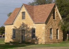 | Abram Click Farmstead | building | 2013 | 13000432 |
 | E. W. Norris Service Station | building | 1976 | 76000832 |
 | F. H. Hart House | building | 1973 | 73000769 |
 | Mitchell County Courthouse | building | 1977 | 77000591 |
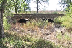 | North Rock Creek Masonry Arch Bridge | structure | 2014 | 14000439 |
 | Old Cawker City Library | building | 1973 | 73000770 |
 | C. A. Perdue House | building | 1976 | 76000831 |
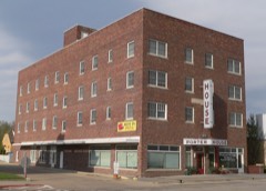 | Porter Hotel | building | 2004 | 04000725 |
 | St. John the Baptist Catholic Church | building | 1975 | 75000717 |
| Wisconsin Street Historic District | district | 1986 | 86001324 |
Every wildfire the federal occurrence database records inside this county: 41 of them, burning about 631 acres. 3 started naturally and 1 was recorded as arson. Each settlement page carries the fires within five miles of it.
| Reported cause | Fires |
|---|---|
| Missing data/not specified/undetermined | 15 |
| Debris and open burning | 9 |
| Equipment and vehicle use | 8 |
| Natural | 3 |
| Misuse of fire by a minor | 2 |
| Power generation/transmission/distribution | 2 |
| Arson/incendiarism | 1 |
| Recreation and ceremony | 1 |
The five largest, by the area the report gives. None of them was recorded as arson.
| Date | Cause | Size | Reported by | Name on the report |
|---|---|---|---|---|
| 6 March 2018 | Debris and open burning | 200 acres | Kansas Forest Service | 3062018 |
| 30 March 2020 | Debris and open burning | 180 acres | Kansas Forest Service | not named |
| 18 April 2020 | Recreation and ceremony | 70 acres | Kansas Forest Service | not named |
| 30 January 2017 | Missing data/not specified/undetermined | 50 acres | Mitchell County | 170004 |
| 31 January 2016 | Debris and open burning | 40 acres | Kansas Forest Service | 1312016 |
| 23 January 2015 | Missing data/not specified/undetermined | 20 acres | Kansas Forest Service | 4 |
| 1 January 2016 | Equipment and vehicle use | 15 acres | Kansas Forest Service | 112016 |
| 2 September 2018 | Natural | 10 acres | Kansas Forest Service | 1 |
Every settlement page carries the fires within five miles of it - see the settlement index below.
The NOAA Storm Events Database holds 578 reports for this county, causing 3 deaths, 23 injuries and about $19,141,800 in recorded property damage. Each settlement page carries the reports that name it.
| Kind of event | Reports |
|---|---|
| Hail | 299 |
| Thunderstorm Wind | 180 |
| Tornado | 50 |
| Heavy Rain | 29 |
| Flash Flood | 15 |
| Flood | 3 |
| Funnel Cloud | 2 |
The most serious of them, by death, then injury, then recorded damage. The accounts are quoted exactly as the forecast office filed them.
| When | Event | Place named | Harm | What the report says |
|---|---|---|---|---|
| July 1989 | Thunderstorm Wind | not stated | 3 killed | no account filed |
| June 1987 | Thunderstorm Wind | not stated | 16 hurt | no account filed |
| June 1967 | Tornado (F2) | not stated | 5 hurt, $2,500,000 | no account filed |
| September 2003 | Flash Flood | Countywide | 1 hurt, $500,000 | no account filed |
| April 1994 | Thunderstorm Wind | Beloit | 1 hurt, $50,000 | Sixty mph winds blew an empty tractor semi-trailer off the road causing it to overturn. The driver received minor injuries. |
| May 2025 | Hail | Beloit Arpt | $1,500,000 | Hail up to two inches in diameter was reported with this round of storms. |
| October 2014 | Hail | Beloit | $750,000 | At 635 am CDT, law enforcement reported that windows were broken from wind-driven hail on the south side of homes about 3 to 8 miles south of Beloit. These homes were located approximately from near Road L to Road P, just east of Highway 14. At 640 am CDT, a trained spotter reported golf ball size hail along with estimated 60 mph wind gusts, 5 miles south of Beloit. |
| October 2014 | Hail | Asherville | $750,000 | At 640 am CDT, law enforcement reported that there were fields with destroyed crops due to the combination of golf ball size hail and strong wind. These fields were on both the north and south sides of Highway 24 from Roads 350 to 380. At 651 am CDT, Law enforcement reported that golf ball size hail was covering Highway 24. A semi-truck slid off the road and overturned at the intersection of Highway 24 and Road 380 due to the copious amount of hail on the road. |
| October 2014 | Thunderstorm Wind | Beloit | $750,000 | Wind speeds at this stage of the storm were estimated at 60 mph. At 635 am CDT, law enforcement reported that windows were broken from wind-driven hail on the south side of homes about 3 to 8 miles south of Beloit. These homes were located approximately from near Road L to Road P, just east of Highway 14. At 640 am CDT, a trained spotter reported golf ball size hail along with estimated 60 mph wind gusts, 5 miles south of Beloit. |
| October 2014 | Thunderstorm Wind | Asherville | $750,000 | Significant home damage was reported in this area. Approximately another mile and a half east, a farm Quonset was destroyed. The sheriff estimated that winds were at least 90 mph. |
| April 2008 | Tornado (EF2) | Beloit Arpt | $750,000 | The tornado sat down north of Beloit near highway 14 and traveled eastward. Several homes, farmsteads, outbuildings and trees were damaged along the tornadoes path. For the first 4 miles of the damage path, the tornado was rated at EF2 with EF0 damage seen through the rest of the county. The tornado exited Mitchell County northeast of Scottsville and entered Cloud County. |
| June 2005 | Thunderstorm Wind | Simpson | $750,000 | no account filed |
| May 2025 | Hail | Beloit | $500,000 | Hail up to ping pong ball size was reported in this round of storms. |
| May 2008 | Tornado (EF2) | Glen Elder | $500,000 | This tornado started near Glen Elder Dam in Mitchell County and moved northeast. It crossed into Jewell County about 4 miles west of Highway 14. Eye witness accounts stated that this tornado combined near the dam with a tornado that had formed to the southwest in Osborne County. Just to the east of the dam, the tornado damaged several outbuildings at a farmstead and uprooted many trees. Power lines and trees were snapped off when the twister crossed US Highway 24 to the east of the town of Glen Elder. Large power poles were broken and another farmstead sustained extensive damage just before the tornado moved into Jewell County. |
| July 1994 | Thunderstorm Wind | Cawker City | $500,000 | Extremely strong thunderstorm winds caused major tree and structural damage throughout the town. |
| August 2021 | Hail | Asherville | $300,000 | Hail ranging in size from golf balls to baseballs was reported in this area. |
| July 2023 | Hail | Simpson | $250,000 | Wind-driven hail resulted in widespread damage to corn, soybean, and milo crops. Full grown milo cut down to three inches. Estimated three mile wide swath centered roughly around 350 Road and Q Road. |
| August 2014 | Hail | Beloit | $250,000 | Both law enforcement and CoCoRaHS observers reported a significant hail storm in Beloit, with comments including: all tender vegetation destroyed and damage to trees, buildings and automobiles. |
| July 2004 | Thunderstorm Wind | Beloit | $250,000 | A radio station reported an 89 mph wind gust. At nearly the same time, a 73 mph wind gust was recorded in town. |
| May 2004 | Hail | Beloit | $250,000 | no account filed |
| June 1992 | Tornado (F2) | not stated | $250,000 | no account filed |
| June 1992 | Tornado (F4) | not stated | $250,000 | no account filed |
| June 1992 | Tornado (F3) | not stated | $250,000 | no account filed |
| June 1992 | Tornado (F1) | not stated | $250,000 | no account filed |
| June 1992 | Tornado (F1) | not stated | $250,000 | no account filed |
| June 1992 | Tornado (F1) | not stated | $250,000 | no account filed |
| June 1992 | Tornado (F2) | not stated | $250,000 | no account filed |
| June 1992 | Tornado (F1) | not stated | $250,000 | no account filed |
| June 1992 | Tornado (F1) | not stated | $250,000 | no account filed |
| June 1992 | Tornado (F2) | not stated | $250,000 | no account filed |
| June 1992 | Tornado (F2) | not stated | $250,000 | no account filed |
| October 1956 | Tornado (F3) | not stated | $250,000 | no account filed |
| May 1950 | Tornado (F2) | not stated | $250,000 | no account filed |
| July 2015 | Thunderstorm Wind | Beloit | $150,000 | There were reports of estimated wind gusts of 60 to 70 MPH, while a gust of 70 MPH measured by a mesonet site west-southwest of Beloit and a gust of 78 MPH measured by the Beloit Airport AWOS. Damage was reported in the Beloit area, including in town where a metal roof was blown off an auto dealer on the north side of town. Numerous trees suffered damage, with a few larger limbs falling on vehicles. A number of power poles were also downed, causing power outages in the Beloit and Glen Elder areas. |
| June 2020 | Flash Flood | Glen Elder | $125,000 | Widespread rainfall amounts of 3 to 6 inches were reported across the area, with the primary impact being numerous rural roads being covered in water and closed. |
| August 2014 | Hail | Beloit | $100,000 | Hail ranging in size from quarters to ping pong balls was reported. |
| April 2012 | Tornado (EF1) | Tipton | $100,000 | This tornado touched down approximately 3 miles south of Tipton, crossed Highway 181 before lifting approximately 1 mile southeast of Tipton. Along its path, trees up to 4 ft in diameter were damaged or destroyed, outbuildings and garages were damaged or destroyed, homes suffered roof and siding damage and power poles were tipped or blown down completely. The maximum wind speed was estimated at 95 mph. |
| June 2005 | Tornado (F1) | Beloit | $100,000 | The Mitchell County Emergency Manager reported a tornado just east of Highway 14 in the southern portion of the county. |
| August 2021 | Hail | Beloit | $100,000 | no account filed |
| June 2005 | Hail | Beloit | $100,000 | no account filed |
| June 2005 | Hail | Beloit | $100,000 | no account filed |
| July 2004 | Thunderstorm Wind | Beloit | $100,000 | no account filed |
| September 2003 | Thunderstorm Wind | Glen Elder | $100,000 | no account filed |
| May 2019 | Tornado (EF2) | Tipton | $75,000 | This tornado initially developed in Russell County, tracking northeast through Osborne County and eventually into far western portions of Mitchell County. This at times large tornado was observed by storm spotters, chasers and residents. Along its path, the tornado damaged several power poles, snapped and uprooted trees and overturned a grain cart. Three farmsteads were damaged, including a destroyed grain bin, outbuildings and sheds. The maximum wind speed was estimated to be 118 MPH. |
| May 2013 | Thunderstorm Wind | Glen Elder | $75,000 | Wind gusts out ahead of and with this thunderstorm produced wind gusts estimated near 70 mph. These wind gusts resulted in roof damage at a lumber yard in Glen Elder and a tree 18 inches in diameter being uprooted 4 miles south of town. Dime to nickel size hail was also reported, with some piles of hail being 6 inches deep. |
| June 2011 | Thunderstorm Wind | Beloit Arpt | $75,000 | The Automated Weather Observing System at Moritz Memorial Airport measured a wind speed of 68 mph. There was widespread tree damage and power loss in the area. |
| June 2011 | Thunderstorm Wind | Cawker City | $75,000 | An estimated wind gust of 75 mph dropped tree limbs throughout Cawker City, which resulted in a lengthy power outage in the area. |
| May 2008 | Flash Flood | Cawker City | $75,000 | Thunderstorms rumbled across northern Kansas and dumped several inches of rain across Mitchell County. This caused several rural roads and area creeks and streams to flood. |
| August 2014 | Hail | Beloit Arpt | $75,000 | no account filed |
| May 2002 | Hail | Cawker City | $70,000 | no account filed |
| April 2001 | Thunderstorm Wind | Beloit | $60,000 | no account filed |
| May 1999 | Thunderstorm Wind | Simpson | $60,000 | no account filed |
| August 2014 | Thunderstorm Wind | Beloit | $50,000 | Wind gusts were estimated to be near 60 MPH. Numerous tree branches were downed across town. |
| May 2013 | Thunderstorm Wind | Beloit | $50,000 | Wind gusts out ahead of and with this thunderstorm produced wind gusts in excess of 60 mph, including a measured gusts of 63 and 67 mph by the Beloit Airport AWOS. These wind gusts resulted in damage to a garage in Beloit and knocked down a couple power poles west-northwest of town. |
| June 2011 | Flood | Cawker City | $50,000 | Runoff from heavy rainfall in excess of 4 inches in Smith and Jewell Counties resulted in flooding along the Solomon River near and downstream of Beloit. |
| May 2008 | Flash Flood | Cawker City Arpt | $50,000 | Thunderstorms were slow to move across Mitchell County during the evening hours. This caused several inches of rain to accumulate in the county. The result was many rural roads became flooded and several small creeks overflowed. |
| May 1993 | Tornado (F0) | Hunter | $50,000 | The tornado moved in from Lincoln county and dissipated before hitting Tipton. (see Lincoln county entry for more details) |
| August 1993 | Hail | Beloit | $50,000 | Automobiles belonging to the sheriff's office were damaged by the hail. |
| October 2017 | Hail | Hunter | $50,000 | no account filed |
| May 2013 | Hail | Hunter | $50,000 | no account filed |
Named settlements recorded in the Geographic Names Information System, each with the topographic sheets covering it. Villages, hamlets and abandoned places alike. Each is shown with the nearest named watercourse or landform and the survey quadrangle it falls on.
Asherville township · 67420 · On Asher Creek · Simpson quadrangle
15 sheets, 1892 to 1985
Eureka township · 67420 · Glasco SW quadrangle
15 sheets, 1892 to 1985
No longer a settlement
Glen Elder township · 67446 · On Limestone Creek · Glen Elder South quadrangle
14 sheets, 1894 to 1985
Turkey Creek township · 67420 · On Dog Creek · Solomon Rapids quadrangle
12 sheets, 1894 to 1985
Blue Hill township · 67420 · On West Rock Creek · Ash Grove quadrangle
12 sheets, 1894 to 1985
The vanished settlements of Mitchell County: the places named above that are no longer on the map.