 Block
From the record
One of 13 National Register listings published here for Mitchell County · listed in 2014 · category: Structure.
Sources: the National Register database, National Park Service
Listed on the National Register of Historic Places in 2014.
One of 13 National Register listings published here for Mitchell County · listed in 2014 · category: Structure.
Sources: the National Register database, National Park Service
Regional context, not property-specific evidence. The federal wildfire occurrence database lists 2 fires within 5 miles of Antelope Creek Masonry Arch Bridge between 2015 and 2020, burning about 6 acres in total. None started naturally. None was recorded as arson. Distance is straight-line from the map coordinates, so a fire counted here may appear on a neighbouring settlement's page as well.
| Reported cause | Fires |
|---|---|
| Equipment and vehicle use | 1 |
| Debris and open burning | 1 |
The most recent of them, most recent first, with the day each was reported and the service that recorded it.
| Date | Cause | Size | Reported by | Name on the report |
|---|---|---|---|---|
| 29 September 2020 | Equipment and vehicle use | 6.0 acres | Kansas Forest Service | not named |
| 8 July 2015 | Debris and open burning | under an acre | Kansas Forest Service | 150022 |
Regional context, not property-specific evidence. The National Weather Service names Tipton, the town this property stands in, in 42 storm reports between 1994 and 2023: 21 hail, 14 thunderstorm wind, 5 tornado, 1 flash flood. No death or injury is recorded in these reports. Each account below is quoted exactly as the forecast office filed it, from the NOAA Storm Events Database, and each date opens the federal record of that event.
| When | Event | Place named | Harm | What the report says |
|---|---|---|---|---|
| April 2012 | Tornado (EF1) | Tipton | $100,000 | This tornado touched down approximately 3 miles south of Tipton, crossed Highway 181 before lifting approximately 1 mile southeast of Tipton. Along its path, trees up to 4 ft in diameter were damaged or destroyed, outbuildings and garages were damaged or destroyed, homes suffered roof and siding damage and power poles were tipped or blown down completely. The maximum wind speed was estimated at 95 mph. |
| May 2019 | Tornado (EF2) | Tipton | $75,000 | This tornado initially developed in Russell County, tracking northeast through Osborne County and eventually into far western portions of Mitchell County. This at times large tornado was observed by storm spotters, chasers and residents. Along its path, the tornado damaged several power poles, snapped and uprooted trees and overturned a grain cart. Three farmsteads were damaged, including a destroyed grain bin, outbuildings and sheds. The maximum wind speed was estimated to be 118 MPH. |
| May 2018 | Flash Flood | Tipton | $30,000 | Ground-truth rainfall of 3 to 6 inches were recorded, though radar estimates in some locations were at least a few inches higher. The main impact from this heavy rain was water running over multiple county roads. |
| May 2019 | Tornado (EF0) | Tipton | $25,000 | One home was damaged by this very brief tornado. A small portion of the roof was peeled off and attic insulation was plastered onto the home and a pickup truck parked outside. Siding was damaged, a small piece of shingle was wedged into a piece of farm equipment and a piece of straw was wedged between a sliding window. Two small trailers were turned. |
| June 2015 | Tornado (EF0) | Tipton | $25,000 | This was a brief tornado that toppled an empty grain bin, and also topped an elm tree and knocked over a metal TV antenna before lifting. |
| May 2015 | Hail | Tipton | $25,000 | no account filed |
| July 2005 | Thunderstorm Wind | Tipton | $25,000 | no account filed |
| June 1996 | Thunderstorm Wind | Tipton | $20,000 | no account filed |
| May 2008 | Tornado (EF1) | Tipton | $10,000 | Storm Chasers captured video of this tornado as it crossed from Osborne County into Mitchell County. Other eye witnesses said this tornado joined with another tornado that had just developed near Glen Elder Dam. Damage from this tornado was limited to trees and power poles as it remained in open country. |
| July 2009 | Thunderstorm Wind | Tipton | $5,000 | Tree damage was reported. |
| July 1994 | Thunderstorm Wind | Tipton | $5,000 | no account filed |
| May 2021 | Thunderstorm Wind | Tipton | $3,000 | A wind gust of 66 MPH was measured by a mesonet station located 6 miles west-southwest of Beloit. A wind gust of 60 MPH was measured by a mesonet station located 7 miles east of Tipton. These wind gusts occurred on the northern edge of stratiform rain from a thunderstorm complex crossing through Lincoln County, causing power pole and tree damage in and around Beloit. |
| June 2008 | Hail | Tipton | $2,000 | no account filed |
| April 1994 | Hail | Tipton | $500 | no account filed |
| June 2023 | Thunderstorm Wind | Tipton | - | A wind gust of 59 MPH was measured by a mesonet station located seven miles east of Tipton. |
| June 2022 | Thunderstorm Wind | Tipton | - | A wind gust of 58 MPH was measured by a mesonet station located one mile east of Tipton. |
| June 2019 | Thunderstorm Wind | Tipton | - | A wind gust of 61 MPH was measured by a mesonet station located 7 miles east of Tipton. |
| May 2019 | Thunderstorm Wind | Tipton | - | A wind gust of 69 MPH was measured by a mesonet state located 7 miles east of Tipton. |
| May 2018 | Heavy Rain | Tipton | - | A storm total rainfall amount of 5.18 inches was measured. |
| May 2011 | Thunderstorm Wind | Tipton | - | Wind gusts were estimated at 60 MPH. |
| June 2005 | Hail | Tipton | - | 60 mph winds near Tipton at the same time as the hail. |
| July 1995 | Hail | Tipton | - | Thunderstorms dropped large hail, up to the size of baseballs, which flattened wheat fields. Hail covered the ground at Tipton and accumulated in drifts near Osborne. |
| June 2022 | Hail | Tipton | - | no account filed |
| June 2021 | Thunderstorm Wind | Tipton | - | no account filed |
| July 2018 | Hail | Tipton | - | no account filed |
| June 2017 | Thunderstorm Wind | Tipton | - | no account filed |
| May 2016 | Hail | Tipton | - | no account filed |
| June 2015 | Hail | Tipton | - | no account filed |
| June 2013 | Hail | Tipton | - | no account filed |
| June 2013 | Hail | Tipton | - | no account filed |
| May 2013 | Hail | Tipton | - | no account filed |
| April 2011 | Hail | Tipton | - | no account filed |
| March 2011 | Hail | Tipton | - | no account filed |
| March 2011 | Hail | Tipton | - | no account filed |
| June 2009 | Hail | Tipton | - | no account filed |
| September 2009 | Hail | Tipton | - | no account filed |
| August 2009 | Hail | Tipton | - | no account filed |
| September 2008 | Hail | Tipton | - | no account filed |
| April 2006 | Hail | Tipton | - | no account filed |
| June 2005 | Hail | Tipton | - | no account filed |
| July 2004 | Thunderstorm Wind | Tipton | - | no account filed |
| June 1999 | Thunderstorm Wind | Tipton | - | no account filed |
No historic map-sheet match is published for this property yet. That does not mean no map exists. This record needs a coordinate-quality review before it can be joined to a sheet boundary. Browse the county's mapped places while that work is pending.
Other National Register properties close enough to walk or drive between, ordered by distance from this one. Both positions come from the same geocoding pass that matched these properties to their map sheets.
| Photograph | Property | Distance | Listed |
|---|---|---|---|
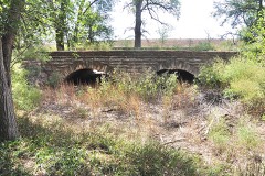 | North Rock Creek Masonry Arch Bridge | 7.4 miles | 2014 |
| National Archives record | The nomination case file for reference 14000437 in Record Group 79. |
| Mitchell County | All 13 listed properties in this county. |