 Block
From the record
12 National Register listings published here.
Sources: the National Register database, National Park Service
43 topographic sheets cover 20 settlements here, and 12 properties are on the National Register of Historic Places.
12 National Register listings published here.
Sources: the National Register database, National Park Service
Every property in this county listed on the National Register of Historic Places, with the year it was listed and the federal nomination document.
| Photograph | Property | Type | Listed | Reference |
|---|---|---|---|---|
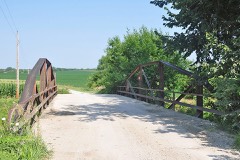 | Clear Creek Camel Truss Bridge | structure | 2003 | 03000360 |
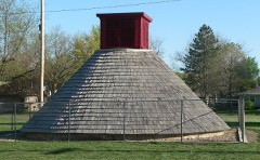 | Hand-Dug City Water Well | structure | 2007 | 07000141 |
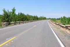 | Lake Nemaha Dam Guardrail | object | 2008 | 08000620 |
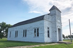 | Marion Hall | building | 2001 | 01000411 |
 | Nemaha County Jail and Sheriff's House | building | 2004 | 04000455 |
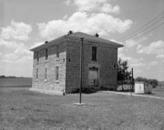 | Old Albany Schoolhouse | building | 1972 | 72000518 |
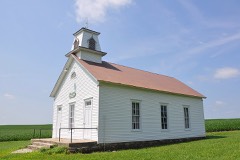 | Prairie Grove School | building | 2006 | 06000113 |
| Seneca Main Street Historic District | district | 2006 | 06000770 | |
 | St. Mary's Church | building | 1980 | 80001470 |
 | US Post Office-Sabetha | building | 1989 | 89001650 |
 | US Post Office-Seneca | building | 1989 | 89001651 |
| John Waggoner House | building | 2025 | 100011682 |
Every wildfire the federal occurrence database records inside this county: 141 of them, burning about 5,411 acres. 1 started naturally and 2 were recorded as arson. Each settlement page carries the fires within five miles of it.
| Reported cause | Fires |
|---|---|
| Missing data/not specified/undetermined | 72 |
| Debris and open burning | 53 |
| Equipment and vehicle use | 7 |
| Smoking | 6 |
| Arson/incendiarism | 2 |
| Natural | 1 |
The five largest, by the area the report gives. None of them was recorded as arson.
| Date | Cause | Size | Reported by | Name on the report |
|---|---|---|---|---|
| 10 April 2020 | Missing data/not specified/undetermined | 420 acres | Kansas Forest Service | not named |
| 22 March 2015 | Missing data/not specified/undetermined | 225 acres | Kansas Forest Service | 21 |
| 25 April 2001 | Debris and open burning | 220 acres | Horton Agency | POO |
| 20 February 2016 | Missing data/not specified/undetermined | 200 acres | Kansas Forest Service | 360 |
| 5 March 2016 | Missing data/not specified/undetermined | 170 acres | Kansas Forest Service | 362 |
| 2 August 2017 | Debris and open burning | 160 acres | Nemaha County | 396 |
| 4 August 2017 | Debris and open burning | 160 acres | Nemaha County | 397 |
| 10 March 2015 | Missing data/not specified/undetermined | 160 acres | Kansas Forest Service | 334 |
Every settlement page carries the fires within five miles of it - see the settlement index below.
The NOAA Storm Events Database holds 513 reports for this county, causing no deaths, 3 injuries and about $11,039,500 in recorded property damage. Each settlement page carries the reports that name it.
| Kind of event | Reports |
|---|---|
| Hail | 245 |
| Thunderstorm Wind | 187 |
| Tornado | 38 |
| Flash Flood | 32 |
| Flood | 7 |
| Lightning | 3 |
| Funnel Cloud | 1 |
The most serious of them, by death, then injury, then recorded damage. The accounts are quoted exactly as the forecast office filed them.
| When | Event | Place named | Harm | What the report says |
|---|---|---|---|---|
| June 2014 | Tornado (EF3) | Bern | 2 hurt | A tornado touched down around the intersection of highway 71 and 63 around 1030 pm CDT. The damage path moved southeast and included several homes that were severely damaged and one totally destroyed. The worst damage occurred to a slab home anchored to the foundation by anchor bolts installed with nuts and washers every 12-18 inches. All exterior and interior walls were destroyed however the debris was primarily laid on top of the slab with some debris blown to the south. Two adult residents took shelter in a tub and survived with minor injuries although the tub was gone and it was suspected to have been blown into a lake to the south. The tornado damage path continued southeast for approximately 6.5 to 7.5 miles total. EF3 rating with winds to around 140 mph. The end time of the tornado was around 1043 pm CDT. |
| April 1999 | Tornado (F1) | Seneca | 1 hurt, $100,000 | A small tornado struck near Seneca and damaged a few farm homes and out buildings. One person was injured. |
| May 1993 | Tornado (F2) | Centralia | $5,000,000 | The longest track tornado of the day moved southwest to northeast across Nemaha county miraculously producing no deaths or injuries. However significant damage occurred to about 20 different farms or farmsteads and related business, machinery and buildings. The tornado just missed populated areas and remained generally in fields and farm areas. Excessive rain in the days after the storm hampered cleanup. Property damage from the tornado was estimated at $1.1 million. In some areas the tornado was about 1/2 mile wide while in other areas damage was only about 100 yards wide. At times the tornado had multiple vortices. |
| June 1998 | Tornado (F2) | Sabetha | $3,500,000 | no account filed |
| July 1994 | Thunderstorm Wind | Seneca | $500,000 | High winds knocked over a large silo on a farrow house killing at least 15 hogs and trapping many others for several days. Other damage to trees, buildings and power lines was reported in the area. |
| May 2007 | Flash Flood | Sabetha | $400,000 | Water reported flowing over rural roads north of Sabetha. |
| April 1999 | Tornado (F1) | Seneca | $350,000 | A tornado touched down 5 miles east of Seneca and moved northeast for about 10 miles. Considerable damage occured to 6 farm buildings. Twelve hogs were killed. |
| December 1975 | Tornado (F1) | not stated | $250,000 | no account filed |
| March 2006 | Tornado (F1) | Sabetha | $200,000 | This F1 tornado touched down 7.5 miles south of Sabetha, damaged one farmstead, then moved east-northeast to the Brown county border, roughly 6 miles south of Sabetha, where it damaged a second farmstead. Debris from the first homestead was scattered over a mile northeast. Some of the debris was lodged in treetops in a nearby woods. Other wood debris was driven several feet into the ground. The tornado had a path length of about 2 miles in Nemaha County with a path width of about 100 yards. The tornado then crossed the border into Brown County. The damage in Nemaha county was estimated at $200,000. This tornado formed in a bow echo that produced an otherwise wide swath of wind damage. |
| May 1996 | Tornado (F1) | Baileyville | $95,000 | no account filed |
| May 2007 | Flash Flood | Sabetha | $50,000 | Several reports of minor street flooding but one road was reported completely under water. |
| April 1999 | Thunderstorm Wind | Centralia | $50,000 | Strong winds damaged 3 to 4 houses near Centralia. |
| July 1994 | Thunderstorm Wind | Baileyville | $50,000 | Winds around 70 mph caused widespread tree and power line damage. Structural damage also occurred to some buildings. |
| July 1994 | Thunderstorm Wind | Sabetha | $50,000 | High winds tore the metal roof from a large horse barn south of town. Chunks of the flying metal hit a horse in the adjacent corral severing its foot just above the hoof. The horse had to be destroyed. The wind also knocked down power lines and trees. |
| May 1996 | Thunderstorm Wind | Seneca | $50,000 | no account filed |
| April 1999 | Thunderstorm Wind | Sabetha | $40,000 | Several barns were blown down and doors on tin sheds were damaged. |
| July 1997 | Hail | Woodlawn | $40,000 | no account filed |
| July 1997 | Hail | Woodlawn | $40,000 | no account filed |
| May 1997 | Thunderstorm Wind | Sabetha | $40,000 | no account filed |
| July 1997 | Hail | Seneca | $30,000 | no account filed |
| June 2010 | Thunderstorm Wind | Corning | $25,000 | Trained spotters throughout Nemaha County reported 70 to 80 mph wind gusts associated with a strong storm that passed through the county. A large silo and many trees were blown over near Centralia. Two Barns, an outbuilding, and trees were destroyed near Corning. |
| June 2004 | Thunderstorm Wind | Centralia | $25,000 | Strong winds blew down a barn. |
| June 1960 | Tornado (F0) | not stated | $25,000 | no account filed |
| July 1997 | Tornado (F1) | Woodlawn | $20,000 | no account filed |
| July 1997 | Tornado (F1) | Seneca | $15,000 | no account filed |
| April 2026 | Flash Flood | Centralia | $10,000 | Kansas department of transportation is shutting down highway K-187 near 112th road due to flooding. |
| April 2026 | Flash Flood | Centralia | $10,000 | Black Vermillion River is out of its banks and threatening the community. |
| April 2026 | Flood | Seneca | $10,000 | The Nemaha River is out of its banks and 146th street is closed west of highway 63. |
| February 2004 | Thunderstorm Wind | St Benedict | $10,000 | Strong winds damaged 3 homes and 2 outbuildings. |
| September 2001 | Thunderstorm Wind | Seneca | $10,000 | Strong winds damaged the roofs of several houses. Several small trailers were tipped over. A propane tank was blown loose from its moorings and upended. |
| May 1997 | Flash Flood | Sabetha | $10,000 | no account filed |
| September 2001 | Lightning | Sabetha | $6,000 | Lightning started a fire that destroyed a barn. |
| June 2010 | Thunderstorm Wind | Baileyville | $5,000 | Trained spotters and law enforcement officers reported 70 to 80 mph wind gusts across Nemaha County. In Seneca, tow large trees were broken. Power lines were damaged and power went out in Seneca. |
| June 1999 | Flash Flood | Seneca | $5,000 | Between 3 and 7 inches of rain fell causing flash flooding doing extensive agricultural damage and closing several roads and highways for a time. Several trailer homes were also evacuated for a time. Some businesses and homes were flooded with some minor damage. |
| July 2001 | Lightning | Sabetha | $4,000 | Lightning struck a house and started a fire that did some damage to the interior. |
| June 1998 | Thunderstorm Wind | Seneca | $3,000 | no account filed |
| June 2000 | Thunderstorm Wind | Centralia | $2,000 | Eighty mph winds caused a roof to collapse. |
| May 1998 | Thunderstorm Wind | Sabetha | $2,000 | no account filed |
| June 1998 | Thunderstorm Wind | Seneca | $2,000 | no account filed |
| July 1997 | Hail | Woodlawn | $2,000 | no account filed |
| May 2005 | Flash Flood | Centralia | $1,000 | Fast flowing water running across highway 187. |
| May 2005 | Flash Flood | Seneca | $1,000 | Fast flowing water running across highway 36 and other area rural roads. |
| May 1998 | Thunderstorm Wind | Centralia | $1,000 | no account filed |
| June 2000 | Thunderstorm Wind | Seneca | $500 | Strong winds blew down a tree and blew out two windows in a law enforcement vehicle. |
| March 2026 | Hail | Corning | - | Quarter size hail fell in the town of Corning. Report relayed from emergency management. |
| June 2025 | Thunderstorm Wind | Woodlawn | - | This is a delayed Report. Spotter called in with tree damage with unknown diameter. |
| June 2025 | Thunderstorm Wind | Sabetha | - | On US highway 36 at the Nemaha and Brown Co line. |
| July 2025 | Flood | Centralia | - | Part of southbound lane of Highway 187 covered by water. |
| May 2024 | Hail | Baileyville | - | Ping pong ball size hail near Baileyville. |
| October 2024 | Thunderstorm Wind | Seneca | - | Personal weather station. |
| October 2024 | Thunderstorm Wind | Seneca | - | Multiple trees down in Seneca, truck blown off Highway 36 east of town. |
| October 2024 | Thunderstorm Wind | Seneca | - | Personal weather station in Seneca. |
| October 2024 | Thunderstorm Wind | Oneida | - | Personal weather station. |
| October 2024 | Thunderstorm Wind | Sabetha | - | Personal weather station. |
| June 2024 | Thunderstorm Wind | Seneca Arpt | - | Wooden frame of a 40 by 80 foot building blown over, with one wall remaining. |
| June 2024 | Thunderstorm Wind | Seneca | - | Large tree 2 to 3 feet in diameter downed. |
| June 2024 | Thunderstorm Wind | Centralia | - | A tree around 8-12 inches in diameter was snapped. A home took siding and window damage, and a sheet metal roof was peeled back on a carport-style outbuilding. |
| June 2024 | Thunderstorm Wind | Corning | - | Estimated by trained spotter. |
| April 2023 | Thunderstorm Wind | Corning | - | Report of several large trees at least a foot in diameter blown down. |
| April 2023 | Hail | Baileyville | - | Golf ball sized hail reported. |
Named settlements recorded in the Geographic Names Information System, each with the topographic sheets covering it. Villages, hamlets and abandoned places alike. Each is shown with the nearest named watercourse or landform and the survey quadrangle it falls on.
Richmond township · 66538 · On North Fork Wildcat Creek · Saint Benedict quadrangle
14 sheets, 1889 to 1986