 Block
From the record
One of 12 National Register listings published here for Nemaha County · listed in 2006 · category: District.
Sources: the National Register database, National Park Service
Listed on the National Register of Historic Places in 2006.
One of 12 National Register listings published here for Nemaha County · listed in 2006 · category: District.
Sources: the National Register database, National Park Service
Regional context, not property-specific evidence. The federal wildfire occurrence database lists 17 fires within 5 miles of Seneca Main Street Historic District between 2015 and 2016, burning about 302 acres in total. None started naturally. None was recorded as arson. Distance is straight-line from the map coordinates, so a fire counted here may appear on a neighbouring settlement's page as well.
| Reported cause | Fires |
|---|---|
| Missing data/not specified/undetermined | 15 |
| Smoking | 2 |
The most recent of them, most recent first, with the day each was reported and the service that recorded it.
| Date | Cause | Size | Reported by | Name on the report |
|---|---|---|---|---|
| 4 September 2015 | Missing data/not specified/undetermined | under an acre | Kansas Forest Service | 41 |
| 8 March 2015 | Missing data/not specified/undetermined | 25 acres | Kansas Forest Service | 12 |
| 22 March 2015 | Missing data/not specified/undetermined | 225 acres | Kansas Forest Service | 21 |
| 21 March 2015 | Missing data/not specified/undetermined | 7.0 acres | Kansas Forest Service | 20 |
| 20 March 2015 | Missing data/not specified/undetermined | under an acre | Kansas Forest Service | 19 |
| 13 March 2015 | Missing data/not specified/undetermined | 45 acres | Kansas Forest Service | 15 |
| 13 March 2015 | Missing data/not specified/undetermined | under an acre | Kansas Forest Service | 16 |
| 10 March 2015 | Missing data/not specified/undetermined | under an acre | Kansas Forest Service | 14 |
Regional context, not property-specific evidence. The National Weather Service names Seneca, the town this property stands in, in 105 storm reports between 1994 and 2026: 46 thunderstorm wind, 44 hail, 6 tornado, 6 flash flood. The reports record 1 injury. Each account below is quoted exactly as the forecast office filed it, from the NOAA Storm Events Database, and each date opens the federal record of that event.
| When | Event | Place named | Harm | What the report says |
|---|---|---|---|---|
| April 1999 | Tornado (F1) | Seneca | 1 hurt, $100,000 | A small tornado struck near Seneca and damaged a few farm homes and out buildings. One person was injured. |
| July 1994 | Thunderstorm Wind | Seneca | $500,000 | High winds knocked over a large silo on a farrow house killing at least 15 hogs and trapping many others for several days. Other damage to trees, buildings and power lines was reported in the area. |
| April 1999 | Tornado (F1) | Seneca | $350,000 | A tornado touched down 5 miles east of Seneca and moved northeast for about 10 miles. Considerable damage occured to 6 farm buildings. Twelve hogs were killed. |
| May 1996 | Thunderstorm Wind | Seneca | $50,000 | no account filed |
| July 1997 | Hail | Seneca | $30,000 | no account filed |
| July 1997 | Tornado (F1) | Seneca | $15,000 | no account filed |
| April 2026 | Flood | Seneca | $10,000 | The Nemaha River is out of its banks and 146th street is closed west of highway 63. |
| September 2001 | Thunderstorm Wind | Seneca | $10,000 | Strong winds damaged the roofs of several houses. Several small trailers were tipped over. A propane tank was blown loose from its moorings and upended. |
| June 1999 | Flash Flood | Seneca | $5,000 | Between 3 and 7 inches of rain fell causing flash flooding doing extensive agricultural damage and closing several roads and highways for a time. Several trailer homes were also evacuated for a time. Some businesses and homes were flooded with some minor damage. |
| June 1998 | Thunderstorm Wind | Seneca | $3,000 | no account filed |
| June 1998 | Thunderstorm Wind | Seneca | $2,000 | no account filed |
| May 2005 | Flash Flood | Seneca | $1,000 | Fast flowing water running across highway 36 and other area rural roads. |
| June 2000 | Thunderstorm Wind | Seneca | $500 | Strong winds blew down a tree and blew out two windows in a law enforcement vehicle. |
| October 2024 | Thunderstorm Wind | Seneca | - | Personal weather station. |
| October 2024 | Thunderstorm Wind | Seneca | - | Multiple trees down in Seneca, truck blown off Highway 36 east of town. |
| October 2024 | Thunderstorm Wind | Seneca | - | Personal weather station in Seneca. |
| June 2024 | Thunderstorm Wind | Seneca | - | Large tree 2 to 3 feet in diameter downed. |
| June 2023 | Thunderstorm Wind | Seneca | - | Estimated wind gust of 60 mph. |
| June 2022 | Thunderstorm Wind | Seneca | - | Report via social media. |
| April 2022 | Hail | Seneca | - | Nickel sized hail reported. |
| June 2022 | Hail | Seneca | - | Report of mainly pea to half inch hail with a few hailstones around quarter size. |
| August 2021 | Thunderstorm Wind | Seneca | - | Report of 3 utility poles and street signs blown down, and numerous trees damaged in the city. |
| December 2021 | Thunderstorm Wind | Seneca | - | Measured at mesonet station k5fvw us-36 at Delaware Road in Sabetha. |
| May 2019 | Hail | Seneca | - | Social media picture. |
| April 2018 | Thunderstorm Wind | Seneca | - | The report estimated 60 MPH winds with penny size hail. |
| March 2017 | Thunderstorm Wind | Seneca | - | Wind damage to an outbuilding and a grain bin. |
| May 2015 | Flash Flood | Seneca | - | Flash flooding was reported along hwy 36 in Seneca and hwy 187 near Centralia. |
| August 2014 | Thunderstorm Wind | Seneca | - | Tree limbs blown down causing power outages in town. Officials also reported roof damage to a cement plant and fence at the baseball field. |
| August 2014 | Thunderstorm Wind | Seneca | - | Tree limbs up to 10 inches in diameter down across hwy 63. |
| August 2014 | Thunderstorm Wind | Seneca | - | Window blown out of a garage door. |
| September 2014 | Thunderstorm Wind | Seneca | - | Reports of power lines broken and several leaning. |
| June 2014 | Thunderstorm Wind | Seneca | - | Power was out due to the winds. |
| May 2013 | Flash Flood | Seneca | - | Report of water over roadway on K63 approx 2 miles north of US36 near Seneca. |
| July 2012 | Thunderstorm Wind | Seneca | - | A trash container was blown 40 feet in town. |
| July 2011 | Thunderstorm Wind | Seneca | - | A trained spotter reported a 60 mph wind near Seneca. |
| September 2010 | Flash Flood | Seneca | - | The County emergency manager reported 6 to 12 inches of water running over Highway 187, 2 miles south Highway 36. |
| September 2010 | Thunderstorm Wind | Seneca | - | A trained spotter near Seneca reported a 70 mph wind gust. |
| June 2009 | Thunderstorm Wind | Seneca | - | A trained spotter reported a 60 mph wind gust. |
| May 2009 | Hail | Seneca | - | Reported at the Nemaha County dispatch center in Seneca. |
| June 2009 | Thunderstorm Wind | Seneca | - | Winds to 60 to 65 mph lasted for 15 minutes. |
| June 2009 | Hail | Seneca | - | This report was relayed by WIBW TV. |
| July 2008 | Thunderstorm Wind | Seneca | - | Spotter called from his vehicle, and reported that his car was being rocked by the strong winds. |
| July 2008 | Thunderstorm Wind | Seneca | - | A spotter called several times to report wind gusts of sixty to seventy miles per hour over the ten minute period. |
| August 2007 | Thunderstorm Wind | Seneca | - | Thunderstorm winds knocked down at least four trees and several tree limbs 6 to 8 inches in diameter in the town of Seneca. One such tree limb fell onto neighboring power lines. |
| July 2006 | Thunderstorm Wind | Seneca | - | Time estimated by the Spotter. |
| June 2001 | Flash Flood | Seneca | - | Heavy rains produced flash flooding for a time with many roads covered by water for a time. |
| April 2000 | Tornado (F0) | Seneca | - | A cold air funnel touched down in an open field near Seneca. |
| June 2000 | Thunderstorm Wind | Seneca | - | A gust to 76 mph was recorded at the mesonet site of a local TV station. |
| June 2000 | Thunderstorm Wind | Seneca | - | Strong winds downed trees in Seneca. |
| June 1999 | Flood | Seneca | - | Over 2 inches of rain fell in a short time period and caused several small creeks and streams to go into minor flooding for a time. Some streets in Seneca were covered with water. Also the Nemaha River and Turkey Creek caused some minor agricultural and road flooding. |
| April 2014 | Hail | Seneca | - | no account filed |
| March 2012 | Hail | Seneca | - | no account filed |
| July 2012 | Hail | Seneca | - | no account filed |
| May 2011 | Hail | Seneca | - | no account filed |
| April 2010 | Hail | Seneca | - | no account filed |
| May 2009 | Hail | Seneca | - | no account filed |
| May 2009 | Hail | Seneca | - | no account filed |
| May 2009 | Hail | Seneca | - | no account filed |
| June 2009 | Hail | Seneca | - | no account filed |
| June 2009 | Hail | Seneca | - | no account filed |
No historic map-sheet match is published for this property yet. That does not mean no map exists. This record needs a coordinate-quality review before it can be joined to a sheet boundary. Browse the county's mapped places while that work is pending.
Other National Register properties close enough to walk or drive between, ordered by distance from this one. Both positions come from the same geocoding pass that matched these properties to their map sheets.
| Photograph | Property | Distance | Listed |
|---|---|---|---|
 | Nemaha County Jail and Sheriff's House | 0.1 miles | 2004 |
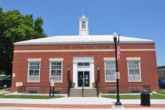 | US Post Office-Seneca | 0.2 miles | 1989 |
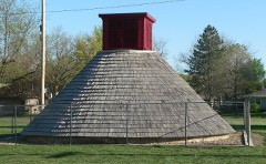 | Hand-Dug City Water Well | 0.4 miles | 2007 |
 | St. Mary's Church | 4.0 miles | 1980 |
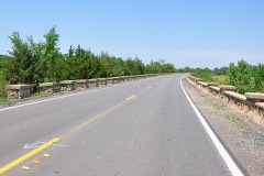 | Lake Nemaha Dam Guardrail | 4.4 miles | 2008 |
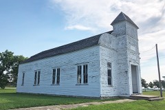 | Marion Hall | 5.9 miles | 2001 |
| National Archives record | The nomination case file for reference 06000770 in Record Group 79. |
| Nemaha County | All 12 listed properties in this county. |