 Block
From the record
6 National Register listings published here.
Sources: the National Register database, National Park Service
44 topographic sheets cover 12 settlements here, and 6 properties are on the National Register of Historic Places.
6 National Register listings published here.
Sources: the National Register database, National Park Service
Every property in this county listed on the National Register of Historic Places, with the year it was listed and the federal nomination document.
| Photograph | Property | Type | Listed | Reference |
|---|---|---|---|---|
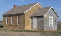 | Lone Star School, District 64 | building | 2009 | 08001352 |
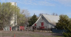 | Miller Farmstead | building | 2012 | 12000869 |
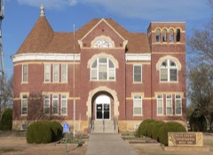 | Rush County Courthouse | building | 1972 | 72000524 |
| Rush County Line Bridge | structure | 86003355 | ||
| Sand Creek Tributary Stone Arch Bridge | structure | 2014 | 14000120 | |
| Walnut Creek Tributary Bridge | structure | 1985 | 85001435 |
Every wildfire the federal occurrence database records inside this county: 33 of them, burning about 177 acres. 2 started naturally and none was recorded as arson. Each settlement page carries the fires within five miles of it.
| Reported cause | Fires |
|---|---|
| Missing data/not specified/undetermined | 21 |
| Equipment and vehicle use | 4 |
| Debris and open burning | 4 |
| Smoking | 2 |
| Natural | 2 |
The five largest, by the area the report gives. None of them was recorded as arson.
| Date | Cause | Size | Reported by | Name on the report |
|---|---|---|---|---|
| 16 March 2015 | Missing data/not specified/undetermined | 50 acres | Kansas Forest Service | 64 |
| 19 July 2018 | Equipment and vehicle use | 25 acres | Kansas Forest Service | 71918 |
| 15 October 2015 | Equipment and vehicle use | 25 acres | Kansas Forest Service | 7 |
| 24 January 2018 | Missing data/not specified/undetermined | 20 acres | Kansas Forest Service | 44877 |
| 5 July 2015 | Missing data/not specified/undetermined | 20 acres | Kansas Forest Service | 65 |
| 10 September 2015 | Natural | 10 acres | Kansas Forest Service | 66 |
| 25 January 2018 | Debris and open burning | 5.0 acres | Kansas Forest Service | 2 |
| 1 September 2017 | Missing data/not specified/undetermined | 2.0 acres | Rush County | 42575 |
Every settlement page carries the fires within five miles of it - see the settlement index below.
The NOAA Storm Events Database holds 707 reports for this county, causing no deaths, 8 injuries and about $5,419,000 in recorded property damage. Each settlement page carries the reports that name it.
| Kind of event | Reports |
|---|---|
| Hail | 449 |
| Thunderstorm Wind | 140 |
| Tornado | 53 |
| Heavy Rain | 37 |
| Flash Flood | 18 |
| Flood | 7 |
| Lightning | 2 |
| Funnel Cloud | 1 |
The most serious of them, by death, then injury, then recorded damage. The accounts are quoted exactly as the forecast office filed them.
| When | Event | Place named | Harm | What the report says |
|---|---|---|---|---|
| June 1968 | Tornado (F3) | not stated | 8 hurt, $250,000 | no account filed |
| May 1999 | Hail | Rush Center | $2,480,000 | Widespread severe weather continued from eastern Colorado, spreading across Rush county during the midnight hour. One person escaped injury by crawling out of bed! Golf ball size hail driven by 70 mph wind smashed through the window and window blind and passed by a man's head as he lay in bed. After the event, hail and glass shreds covered the bed. Loss to wildlife and some livestock across the county was heavy. There was a report of several dead cattle and many injured cow and horses. One-hundred thousand acres of wheat were mowed down, 3,500 acres of corn damaged and 4,000 acres of alfalfa destroyed (first cutting). $480,000 in damage was done to farm equipment across the county (included in the $2.48m) |
| July 2005 | Hail | Otis | $740,000 | Large hail and strong winds across Rush county caused 50 percent crop damage to 95,000 acres. |
| June 1996 | Thunderstorm Wind | Alexander | $550,000 | no account filed |
| July 2005 | Hail | La Crosse | $500,000 | The hail broke out 20 windows at the Rush county courthouse. Two patrol cars had their windshields broken out. Windows were also broken out of the St. Michaels Catholic Church...along with numerous homes and businesses. |
| April 2001 | Tornado (F2) | Rush Center | $200,000 | Two farms received heavy damage (grain bins, roofs, shed and vehicle) |
| July 2010 | Thunderstorm Wind | Bison | $175,000 | A mile of power poles were blown down east of Bison. |
| April 2012 | Tornado (EF1) | Rush Center | $125,000 | A tornado damaged a pivot sprinkler, trees and a few out buildings. |
| July 2010 | Thunderstorm Wind | Timken | $50,000 | A pivot irrigation sprinkler was blown over near mile marker 154 on Highway 96. |
| March 1998 | Hail | Otis | $50,000 | Damage occurred to vehicles throughout the town. |
| May 1999 | Thunderstorm Wind | Timken | $50,000 | no account filed |
| August 2006 | Thunderstorm Wind | La Crosse | $30,000 | Twenty 26 power poles were blown down along highway 183 closing the highway between Rush Center and La Crosse. |
| June 1996 | Thunderstorm Wind | La Crosse | $30,000 | no account filed |
| May 1990 | Tornado (F0) | not stated | $25,000 | no account filed |
| August 1974 | Tornado (F1) | not stated | $25,000 | no account filed |
| September 1970 | Tornado (F1) | not stated | $25,000 | no account filed |
| June 1964 | Tornado (F2) | not stated | $25,000 | no account filed |
| May 1950 | Tornado (F1) | not stated | $25,000 | no account filed |
| May 2011 | Thunderstorm Wind | Rush Center | $14,000 | High winds produced minor roof damage, blew down signs and blew down 11 power poles between LaCrosse and Rush Center. |
| May 2008 | Flood | La Crosse | $12,000 | Water was out of the banks of Sand Creek and flooded some of the streets in the area. |
| May 1996 | Tornado (F1) | Bazine | $10,000 | no account filed |
| May 2004 | Thunderstorm Wind | Rush Center | $6,000 | Twelve power poles were blown down just east of highway 183 |
| July 2011 | Thunderstorm Wind | Loretta | $5,000 | Five power poles were blown down just west of Loretta. |
| June 1997 | Thunderstorm Wind | Mc Cracken | $3,000 | Four inch "live" tree limbs blown down. |
| April 1973 | Tornado (F2) | not stated | $2,500 | no account filed |
| July 1958 | Tornado | not stated | $2,500 | no account filed |
| August 2016 | Thunderstorm Wind | Otis | $2,000 | Two power poles were blown down along highway K4. |
| June 2000 | Thunderstorm Wind | Mc Cracken | $2,000 | Camper overturned and the tops blown out of two large trees. |
| May 1998 | Hail | La Crosse | $2,000 | Hail swath of 7 miles wide produced total devastation to some of the native grasses and destroyed most of the wheat. A USDA report indicated some hail up to softball size but gave no specific information. |
| June 1997 | Thunderstorm Wind | La Crosse | $1,000 | Tree blown down. |
| July 2000 | Thunderstorm Wind | Alexander | $500 | Power pole blown down. |
| July 1998 | Lightning | Otis | $500 | Light caused a fire that destroyed 200 bales of hay. |
| June 1998 | Thunderstorm Wind | Otis | $500 | Power pole snapped |
| August 1951 | Tornado | not stated | $250 | no account filed |
| September 1951 | Tornado | not stated | $250 | no account filed |
| April 2026 | Hail | Shaffer | - | A public report of 1 inch hail. |
| April 2026 | Hail | Mc Cracken | - | A public report of 1 inch hail. |
| April 2026 | Hail | La Crosse Hoover Arp | - | Social media report of ping pong ball sized hail on the south side of La Crosse. |
| April 2026 | Hail | La Crosse Hoover Arp | - | A public report of 1.25 inch hail. |
| April 2026 | Hail | Rush Center | - | A public report of 1.25 inch hail. There was 2 other reports of 1 inch hail around the same time and place. |
| July 2025 | Thunderstorm Wind | Liebenthal | - | Estimated wind gusts by law enforcement. |
| September 2025 | Hail | Liebenthal | - | A public report of 1 inch hail. |
| October 2025 | Thunderstorm Wind | Rush Center | - | A mesonet site recorded a 57 mph wind gust. |
| July 2024 | Thunderstorm Wind | La Crosse Hoover Arp | - | Mesonet station FW1214 La Crosse. |
| July 2024 | Thunderstorm Wind | La Crosse Hoover Arp | - | Mesonet station FW1214 La Crosse. |
| July 2024 | Thunderstorm Wind | La Crosse Hoover Arp | - | Mesonet station FW1214 La Crosse. |
| July 2024 | Thunderstorm Wind | La Crosse Hoover Arp | - | Mesonet station FW1214 La Crosse. |
| June 2024 | Thunderstorm Wind | Alexander | - | A wind gust of 73 mph reported. |
| September 2023 | Tornado (EF0) | Nekoma | - | A highly visible Landspout tornado moved slowly northwest from 552 to 558 pm. Numerous pictures of this event were shared on social media. This Landspout flipped a section of center pivot just south of Highway 96. |
| April 2022 | Thunderstorm Wind | La Crosse Hoover Arp | - | Mesonet site at LaCrosse. |
| April 2021 | Hail | Rush Center | - | Nickle to quarter sized hail. |
| May 2021 | Hail | La Crosse | - | Most of the hail was dime sized and the hail covered the road. |
| May 2021 | Thunderstorm Wind | Hargrave | - | Winds were estimated to be 60 to 70 MPH. |
| May 2021 | Flash Flood | La Crosse Hoover Arp | - | The flooding was mostly on city streets and on the edge of town. |
| September 2021 | Heavy Rain | Shaffer | - | Rainfall of 2.96 inches was observed. |
| September 2021 | Heavy Rain | Bison | - | Rainfall of 3.10 inches was observed. |
| September 2021 | Heavy Rain | La Crosse Hoover Arp | - | Rainfall of 2.06 inches was observed. |
| September 2021 | Heavy Rain | Otis | - | Rainfall of 3.70 inches was observed. |
| September 2021 | Heavy Rain | Liebenthal | - | Rainfall of 3.19 inches was observed. |
| August 2021 | Hail | Loretta | - | Relayed from TV Media. |
Named settlements recorded in the Geographic Names Information System, each with the topographic sheets covering it. Villages, hamlets and abandoned places alike. Each is shown with the nearest named watercourse or landform and the survey quadrangle it falls on.
La Crosse-Brookdale township · 67548 · On Mule Creek · La Crosse quadrangle
15 sheets, 1896 to 1985
Center township · 67575 · On Otter Creek · Rush Center quadrangle
15 sheets, 1889 to 1985