 Block
From the record
5 National Register listings published here.
Sources: the National Register database, National Park Service
30 topographic sheets cover 14 settlements here, and 5 properties are on the National Register of Historic Places.
5 National Register listings published here.
Sources: the National Register database, National Park Service
Every property in this county listed on the National Register of Historic Places, with the year it was listed and the federal nomination document.
| Photograph | Property | Type | Listed | Reference |
|---|---|---|---|---|
| Athol Community Hall | building | 2025 | 100012145 | |
 | First National Bank Building | building | 2006 | 06001163 |
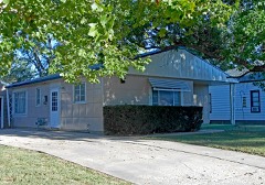 | Grimes House | building | 2001 | 01000192 |
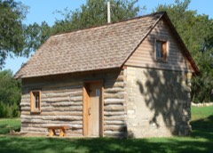 | Home on the Range Cabin | building | 1973 | 73000780 |
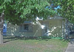 | Martyn House | building | 2001 | 01000195 |
Every wildfire the federal occurrence database records inside this county: 39 of them, burning about 3,992 acres. 1 started naturally and 1 was recorded as arson. Each settlement page carries the fires within five miles of it.
| Reported cause | Fires |
|---|---|
| Missing data/not specified/undetermined | 16 |
| Equipment and vehicle use | 11 |
| Debris and open burning | 10 |
| Arson/incendiarism | 1 |
| Natural | 1 |
The five largest, by the area the report gives. None of them was recorded as arson.
| Date | Cause | Size | Reported by | Name on the report |
|---|---|---|---|---|
| 27 October 1999 | Debris and open burning | 1,500 acres | Kirwin National Wildlife Refuge | KENSINGTON |
| 6 March 2017 | Missing data/not specified/undetermined | 1,100 acres | Smith County | 2017020 |
| 29 February 2020 | Missing data/not specified/undetermined | 500 acres | Smith County | BILL ANDERSON |
| 16 March 2015 | Equipment and vehicle use | 450 acres | Kansas Forest Service | 2015002 |
| 6 April 2017 | Debris and open burning | 160 acres | Smith County | 2017026 |
| 17 March 2015 | Missing data/not specified/undetermined | 80 acres | Kansas Forest Service | 2015003 |
| 5 March 2018 | Missing data/not specified/undetermined | 80 acres | Kansas Forest Service | 2018001 |
| 6 March 2016 | Missing data/not specified/undetermined | 50 acres | Kansas Forest Service | 1 |
Every settlement page carries the fires within five miles of it - see the settlement index below.
The NOAA Storm Events Database holds 507 reports for this county, causing no deaths, 2 injuries and about $21,466,100 in recorded property damage. Each settlement page carries the reports that name it.
| Kind of event | Reports |
|---|---|
| Hail | 271 |
| Thunderstorm Wind | 159 |
| Tornado | 42 |
| Heavy Rain | 15 |
| Flash Flood | 10 |
| Flood | 5 |
| Funnel Cloud | 4 |
| Lightning | 1 |
The most serious of them, by death, then injury, then recorded damage. The accounts are quoted exactly as the forecast office filed them.
| When | Event | Place named | Harm | What the report says |
|---|---|---|---|---|
| May 2013 | Tornado (EF3) | Lebanon | 1 hurt, $1,400,000 | This tornado affected two counties in north central Kansas, touching down north of Lebanon in Smith County and lifting north of Esbon in Jewell County. The maximum wind speed was estimated to be near 140 MPH, with a maximum path width of 1580 yards. Along its path, this tornado caused minor to major tree damage, overturned irrigation pivots, snapped power poles and damaged or destroyed grain bins and outbuildings. Four homesteads suffered damage, with the hardest hit locations approximately 3 miles northeast of Lebanon in Smith County. Two homes in this area were heavily damaged or destroyed, with one losing its entire second level. This location also completely lost grain bins, a large outbuilding and newly constructed garage. One person suffered minor injuries and was treated and released from an area hospital. |
| May 1965 | Tornado (F2) | not stated | 1 hurt, $25,000 | no account filed |
| April 1990 | Tornado (F1) | not stated | $2,500,000 | no account filed |
| May 1985 | Tornado (F4) | not stated | $2,500,000 | no account filed |
| June 1957 | Tornado (F3) | not stated | $2,500,000 | no account filed |
| June 1957 | Tornado (F3) | not stated | $2,500,000 | no account filed |
| June 2011 | Flood | Lebanon | $1,000,000 | Heavy rain in excess of 4 inches cause widespread flooding in southeast Smith County. The worst flood conditions were felt along the Oak Creek near Dispatch and its upstream tributaries. |
| May 2002 | Thunderstorm Wind | Harlan | $1,000,000 | no account filed |
| May 2024 | Hail | Smith Center | $500,000 | no account filed |
| July 2001 | Thunderstorm Wind | Gaylord | $500,000 | no account filed |
| July 1998 | Flash Flood | North Portion | $500,000 | no account filed |
| July 2023 | Hail | Cedar | $250,000 | Ping pong to golf ball size hail was reported in the area. Spotter reported damaged windows on vehicle and home and damaged vinyl home siding. |
| May 2021 | Hail | Smith Center | $250,000 | Hail ranging anywhere from pea size to 2 inches in diameter was reported in Smith Center from a number of sources. |
| August 2014 | Hail | Lebanon | $250,000 | no account filed |
| May 1986 | Tornado (F1) | not stated | $250,000 | no account filed |
| May 1982 | Tornado (F1) | not stated | $250,000 | no account filed |
| August 2014 | Thunderstorm Wind | Lebanon | $200,000 | Wind gusts were estimated to be upwards of 80 MPH. Emergency management reported that 14 power poles and numerous tree limbs were downed. |
| July 2023 | Hail | Kensington | $150,000 | Hail up to ping pong to golf ball size was reported in Kensington. |
| October 2017 | Hail | Kensington | $150,000 | Hail ranging in size from golf balls to hen eggs was reported in and near Kensington. |
| August 2014 | Thunderstorm Wind | Lebanon | $150,000 | Wind gusts were estimated to be between 70 and 80 MPH and were accompanied by golf ball size hail. |
| August 2014 | Hail | Lebanon | $150,000 | Hail ranging in size from half dollars to golf balls was reported. |
| August 2011 | Thunderstorm Wind | Gaylord | $125,000 | Wind gusts estimated at 80 MPH resulted in 17 power poles being damaged or destroyed in the area of the intersection of Highways 9 and 281 just east of Gaylord. Further south near Harlan along Highway 281, a couple grain bins were destroyed and a church suffered minor roof damage. |
| May 2025 | Flash Flood | Cora | $100,000 | Strong thunderstorms dropped as much as 4 to 6 inches of heavy rain across the area. Rural roads in the area were affected by running water, as were a portion of Highway 78/128 near the border of Webster County, NE and Jewell County, KS and a portion of Highway 281 in Smith County, KS. Some of the highest measured rain totals included: 5.62 inches from nine miles north-northwest of Burr Oak, KS; 5.61 inches from three miles east of Guide Rock, NE; 5.60 inches from six miles north of Esbon; 4.84 inches from four miles north-northwest of Bostwick. |
| May 2024 | Thunderstorm Wind | Athol | $100,000 | Wind gusts estimated to be near 70 MPH resulted in the destruction of a new outbuilding as well as tree damage in the general area. |
| July 2004 | Hail | Smith Center | $100,000 | Hail ranging in size from pennies to golf balls pounded Smith Center for about 20 minutes. |
| June 2010 | Flash Flood | Gaylord | $100,000 | no account filed |
| June 2005 | Thunderstorm Wind | Gaylord | $100,000 | no account filed |
| September 2003 | Thunderstorm Wind | Smith Center | $100,000 | no account filed |
| June 2000 | Thunderstorm Wind | Kensington | $100,000 | no account filed |
| May 1999 | Hail | Cora | $100,000 | no account filed |
| September 1997 | Thunderstorm Wind | Smith Center | $80,000 | no account filed |
| July 2024 | Thunderstorm Wind | Cedar | $75,000 | Delayed video from social media showing power pole damage in the area as well as damage to a grain bin. |
| May 2008 | Flash Flood | Reamsville | $75,000 | Thunderstorms rumbled across northern Kansas and dumped several inches of rain across Smith County. This caused several rural roads and area creeks and streams to flood. |
| May 2002 | Hail | Lebanon | $75,000 | no account filed |
| August 2002 | Thunderstorm Wind | Smith Center | $75,000 | no account filed |
| April 2001 | Tornado (F1) | Gaylord | $75,000 | no account filed |
| July 1998 | Heavy Rain | Womer | $75,000 | no account filed |
| June 1999 | Thunderstorm Wind | Smith Center | $65,000 | no account filed |
| May 2008 | Hail | Smith Center | $60,000 | Hail up to an inch and a half in diameter fell between 836 and 841 PM in the town of Smith Center. Damage from the hail was mainly to roofs, trees and a few windows. |
| May 2024 | Thunderstorm Wind | Smith Center Arpt | $50,000 | Wind gusts of 79 MPH and 68 MPH were measured by the Smith Center Airport AWOS. Law enforcement reported tree damage across town as well as damage to a local store sign. |
| May 2015 | Thunderstorm Wind | Smith Center Arpt | $50,000 | The end time of these strong winds is unknown, as the AWOS was inoperable following this gust. The cooperative observer in Smith Center reported that large tree limbs and power were downed. |
| June 2014 | Thunderstorm Wind | Kensington | $50,000 | A line of thunderstorms producing strong winds moved through Smith County, with gusts estimated near 80 MPH in Kensington. A wind gust of 68 MPH was measured at the Smith Center Airport AWOS at 11:05 p.m. CDT and a gust of 63 MPH was measured by a Kansas Department of Transportation mesonet site 2 miles south of Lebanon at 11:25 p.m. CDT. |
| June 2013 | Hail | Lebanon | $50,000 | Most of the hail was quarter size with a few near ping pong ball size. |
| May 2008 | Flash Flood | Reamsville | $50,000 | Thunderstorms dumped heavy rains of 3 to 4 inches across this area. This caused several creeks to go out of their banks and many rural roads were flooded. |
| July 1994 | Thunderstorm Wind | Kensington | $50,000 | Strong thunderstorm winds blew down several power poles in the area. |
| May 1993 | Tornado (F1) | Thornburg | $50,000 | This tornado touched down in the Thornburg area and damaged a church before moving out across open country and dissipating. |
| May 2018 | Hail | Athol | $50,000 | no account filed |
| May 2007 | Hail | Smith Center | $50,000 | no account filed |
| May 2007 | Thunderstorm Wind | Smith Center | $50,000 | no account filed |
| May 2002 | Thunderstorm Wind | Smith Center | $50,000 | no account filed |
| May 2002 | Hail | Lebanon | $50,000 | no account filed |
| May 2002 | Thunderstorm Wind | Gaylord | $50,000 | no account filed |
| May 2002 | Thunderstorm Wind | Claudell | $50,000 | no account filed |
| June 1999 | Thunderstorm Wind | Smith Center | $50,000 | no account filed |
| August 1998 | Hail | Smith Center | $50,000 | no account filed |
| July 1996 | Thunderstorm Wind | Lebanon | $50,000 | no account filed |
| June 1996 | Hail | Smith Center | $50,000 | no account filed |
| September 1993 | Hail | Gaylord | $50,000 | no account filed |
| September 1993 | Hail | Smith Center | $50,000 | no account filed |
| May 2007 | Tornado (EF0) | Gaylord | $45,000 | A brief tornado touched down in a field southeast of Gaylord. An off-duty NWS Employee reported a funnel cloud in the area. According to the Smith County Pioneer newspaper, the tornado damaged a center pivot system. The Pioneer also reported a man witnessed the pivot go up in the air along with other loose debris flying around. No other damage was reported from this tornado. |
Named settlements recorded in the Geographic Names Information System, each with the topographic sheets covering it. Villages, hamlets and abandoned places alike. Each is shown with the nearest named watercourse or landform and the survey quadrangle it falls on.