 Block
From the record
20 National Register listings published here.
Sources: the National Register database, National Park Service
64 topographic sheets cover 16 settlements here, and 20 properties are on the National Register of Historic Places.
20 National Register listings published here.
Sources: the National Register database, National Park Service
Every property in this county listed on the National Register of Historic Places, with the year it was listed and the federal nomination document.
| Photograph | Property | Type | Listed | Reference |
|---|---|---|---|---|
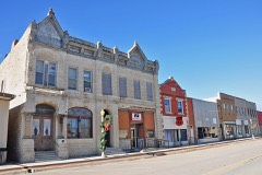 | Alma Downtown Historic District | district | 2009 | 09000354 |
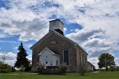 | Beecher Bible and Rifle Church | building | 1971 | 71000334 |
 | Brandt Hotel | building | 2008 | 08000617 |
| East Stone Arch Bridge - Lake Wabaunsee | structure | 2009 | 09001170 | |
| Eskridge Bandstand | structure | 2017 | 16000133 | |
| Fix Farmstead | district | 2015 | 15000149 | |
| Grimm-Schultz Farmstead | district | 2020 | 100005635 | |
| Mount Mitchell Heritage Prairie Historic District | district | 2022 | 100007422 | |
 | Paxico Historic District | district | 1998 | 98001289 |
| Paxico Rural High School | building | 2022 | 100007925 | |
| Pearl Opera House | building | 2024 | 100010620 | |
| Pratt-Mertz Barn | building | 2020 | 100004928 | |
 | Security State Bank | building | 1982 | 82002678 |
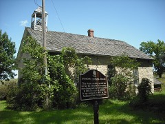 | Snokomo School | building | 1995 | 94001576 |
 | Southeast Stone Arch Bridge - Lake Wabaunsee | structure | 2009 | 09001171 |
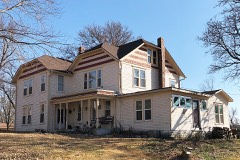 | Stuewe House | building | 2007 | 06001245 |
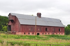 | Sump Barn | building | 2022 | 100007708 |
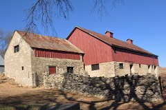 | Peter Thoes Barn | building | 2013 | 13000856 |
 | Wabaunsee County Courthouse | building | 2002 | 02000399 |
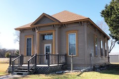 | Wabaunsee District #1 Grammar School | building | 2005 | 05001238 |
Every wildfire the federal occurrence database records inside this county: 158 of them, burning about 27,924 acres. 1 started naturally and 18 were recorded as arson. Each settlement page carries the fires within five miles of it.
| Reported cause | Fires |
|---|---|
| Missing data/not specified/undetermined | 60 |
| Debris and open burning | 53 |
| Arson/incendiarism | 18 |
| Equipment and vehicle use | 14 |
| Smoking | 8 |
| Recreation and ceremony | 2 |
| Misuse of fire by a minor | 1 |
| Natural | 1 |
| Fireworks | 1 |
The five largest, by the area the report gives. None of them was recorded as arson.
| Date | Cause | Size | Reported by | Name on the report |
|---|---|---|---|---|
| 24 February 1996 | Missing data/not specified/undetermined | 12,000 acres | Shawnee County | not named |
| 7 March 2018 | Missing data/not specified/undetermined | 3,200 acres | Wabaunsee County | ECHO CLIFF |
| 7 April 2017 | Missing data/not specified/undetermined | 1,800 acres | Wabaunsee County | WARREN ROAD |
| 18 March 1994 | Missing data/not specified/undetermined | 1,600 acres | Wabaunsee County | not named |
| 20 April 2018 | Debris and open burning | 1,500 acres | Kansas Forest Service | 18-0037 |
| 31 January 2009 | Missing data/not specified/undetermined | 1,200 acres | Kansas Counties | SHINKLE |
| 11 April 2009 | Missing data/not specified/undetermined | 730 acres | Kansas Counties | PORTER |
| 13 March 2015 | Missing data/not specified/undetermined | 500 acres | Kansas Forest Service | 15-0013 |
Every settlement page carries the fires within five miles of it - see the settlement index below.
The NOAA Storm Events Database holds 574 reports for this county, causing 2 deaths, 28 injuries and about $31,271,460 in recorded property damage. Each settlement page carries the reports that name it.
| Kind of event | Reports |
|---|---|
| Hail | 290 |
| Thunderstorm Wind | 191 |
| Tornado | 47 |
| Flash Flood | 35 |
| Lightning | 4 |
| Flood | 4 |
| Funnel Cloud | 2 |
| Heavy Rain | 1 |
The most serious of them, by death, then injury, then recorded damage. The accounts are quoted exactly as the forecast office filed them.
| When | Event | Place named | Harm | What the report says |
|---|---|---|---|---|
| February 2012 | Tornado (EF2) | Harveyville | 1 killed, 12 hurt | As the line of thunderstorms moved eastward across northeast Kansas on of the strongest storms spawned a brief, but very strong tornado, which impacted the town of Harveyville, Kansas. The tornado was short-lived, but was able to destroy a large portion of the town. Several houses were completely destroyed, as was a church in the center of town. A National Weather Service survey team determined that the tornado rated an EF-2 on the Enhanced Fujita Scale. At least a dozen injuries occurred with this storm, one of which became fatal after a day in the hospital. The tornado continued into Osage County and weakened. |
| May 1996 | Flash Flood | Hessdale | 1 killed, $99,000 | no account filed |
| May 1960 | Tornado (F4) | not stated | 12 hurt, $25,000,000 | no account filed |
| July 1994 | Thunderstorm Wind | Paxico | 2 hurt, $500,000 | Winds estimated to at least 70 mph caused widespread damage across the county. A couple near Paxico was briefly trapped in their mobile home when it was detached from its cables and flipped over. The uninsured mobile home was destroyed. The couple was treated for minor injuries at a hospital. Other damage to trees, power lines and roofs was common. Many crops were severely damaged in the storm. |
| June 2024 | Thunderstorm Wind | Maple Hill | 2 hurt | KHP reports a semi truck was blown off of I-70 due to high winds. Two occupants were treated for minor injuries. |
| March 1990 | Tornado (F2) | not stated | $2,500,000 | no account filed |
| May 1993 | Tornado (F1) | Eskridge | $500,000 | A tornado bounced up and down along a northeast track through the eastern part of the county, mainly in farmland. About half dozen buildings were damaged. At times the tornado had multiple vorticies. This tornado was one of 12 confirmed tornadoes that struck northeast Kansas on the evening of May 6th. Several had multiple vortices that were initially reported as more than one tornado. |
| May 1995 | Hail | Alma | $400,000 | Large hail driven by 60 to 80 mph winds caused widespread damage throughout the north half of the county. Many windows were broken, siding chip and riped and vehicles damaged. Several school buildings suffered enough damage to cancel class for at least a day. |
| April 2002 | Thunderstorm Wind | Alma | $381,000 | Strong winds blew down beams on a new high school under construction in Alma. |
| April 1991 | Tornado (F2) | not stated | $250,000 | no account filed |
| August 1985 | Tornado (F3) | not stated | $250,000 | no account filed |
| March 1974 | Tornado (F2) | not stated | $250,000 | no account filed |
| March 1974 | Tornado (F2) | not stated | $250,000 | no account filed |
| June 1967 | Tornado (F1) | not stated | $250,000 | no account filed |
| June 2005 | Flash Flood | Paxico | $100,000 | Over 6 inches of fast flowing water over highway 18 and over several county roads. |
| September 2005 | Flash Flood | Maple Hill | $100,000 | no account filed |
| May 2007 | Flash Flood | Harveyville | $50,000 | Two to four feet of water over eight mile road north of Harveyville. |
| May 2007 | Flash Flood | Maple Hill | $50,000 | Water starting to cover road K30. |
| May 2007 | Flash Flood | Wabaunsee | $50,000 | K-18 closed near the town of Wabaunsee. Water over the highway. |
| June 2004 | Thunderstorm Wind | Alta Vista | $45,000 | Strong winds damaged several outbuildings and silos. |
| April 1991 | Tornado (F0) | not stated | $25,000 | no account filed |
| April 1968 | Tornado (F2) | not stated | $25,000 | no account filed |
| May 1959 | Tornado (F1) | not stated | $25,000 | no account filed |
| May 1959 | Tornado (F1) | not stated | $25,000 | no account filed |
| June 1958 | Tornado (F2) | not stated | $25,000 | no account filed |
| September 2010 | Thunderstorm Wind | Chalk Mound | $20,000 | Large trees were blown down across portions of Wabaunsee County. North of Bushong, the Chalk COOP observer reported a large dome blown off of his silo, which was also caved in due to the wind. Large hay bales were blown off of a parked semi-truck, and additional power poles were snapped. The winds continued to Harveyville, where more power poles were blown down. |
| June 2004 | Thunderstorm Wind | Alta Vista | $15,000 | Strong winds blew down tree limbs as large as 2 feet in diameter onto vehicles doing damage. |
| May 1995 | Tornado (F0) | Harveyville | $15,000 | A small weak tornado damaged some buildings, a barn and knocked down power poles and lines. Wheat and a few other crops were also damaged or destroyed. |
| June 2007 | Flash Flood | Eskridge | $10,000 | Approximately 2.5 of rain had fallen in less than three hours. KDOT relayed a report from deputies that water was flowing over K-4, 2 to 4 miles north of Eskridge. Elsewhere in the county, a deputy 3 miles north of Harveyville reported that water was overflowing the banks of Coon Creek. The excessive water spilled over Walton Road, between Harveyville and Calson Road. Water was reported to be 3 to 4 feet deep. |
| March 2002 | Thunderstorm Wind | Alma | $6,000 | Strong winds blew down trees and damaged several buildings. |
| July 2004 | Thunderstorm Wind | Eskridge | $5,000 | Strong winds snapped a 15 inch diameter telephone pole at ground level. A number of tree limbs were also snapped. One of the tree limbs hit the roof of a house and knocked an attic fan from the ceiling. |
| August 2004 | Lightning | Eskridge | $5,000 | Lightning struck a house in Eskridge and ignited a fire that did some damage to the house. |
| April 2001 | Thunderstorm Wind | Paxico | $5,000 | Strong thunderstorm winds blew the roof off a junior high school. |
| April 2002 | Thunderstorm Wind | Alma | $4,000 | Strong winds damaged several buildings in Alma. |
| May 2003 | Thunderstorm Wind | Wabaunsee | $3,000 | Strong winds blew down a tree limb, broke some windows, and overturned some sheds northeast of Wabaunsee. |
| April 2002 | Thunderstorm Wind | Alma | $3,000 | Strong winds blew down power lines and tore off tree limbs. |
| August 2000 | Thunderstorm Wind | Maple Hill | $3,000 | Strong thunderstorm winds tore shingles off a roof and lifted a camper off a trailer near Maple Hill. |
| June 1999 | Lightning | Paxico | $3,000 | Two bolts of lightning struck a 2 story farm house igniting a fire that heavily damaged the structure. |
| April 1981 | Tornado (F1) | not stated | $2,500 | no account filed |
| April 1964 | Tornado (F1) | not stated | $2,500 | no account filed |
| March 1954 | Tornado (F2) | not stated | $2,500 | no account filed |
| July 2011 | Thunderstorm Wind | Chalk Mound | $2,000 | A brick chimney on a house was blown over by strong winds. |
| September 2010 | Thunderstorm Wind | Alta Vista | $2,000 | Two tree up to 2 feet in diameter snapped in half along K4 Highway. |
| March 1998 | Thunderstorm Wind | Volland | $2,000 | no account filed |
| August 1997 | Thunderstorm Wind | Alta Vista | $2,000 | no account filed |
| May 1997 | Thunderstorm Wind | Paxico | $2,000 | no account filed |
| June 2009 | Hail | Alta Vista | $1,000 | Tree damage and bay window broken on house were reported. |
| June 2009 | Hail | Alta Vista | $1,000 | Tree damage and bay window broken was on house. |
| May 2007 | Flash Flood | Maple Hill | $1,000 | Highway K-30 between Interstate 70 and Maple Hill closed due to high water from flash flooding. |
| May 2005 | Flash Flood | South Portion | $1,000 | Intense rains brought fast flowing water across K-4 highway. |
| July 2004 | Thunderstorm Wind | Maple Hill | $1,000 | Strong winds damaged a road sign along Interstate 70. |
| October 1998 | Lightning | Alma | $1,000 | Lightning struck a car traveling on K-99 highway destroying a ham radio and burning off a ham radio antenna and produced burns on the trunk. |
| June 1994 | Thunderstorm Wind | Alma | $500 | no account filed |
| August 2004 | Lightning | Alma | $400 | Lightning struck a home and damaged an air conditioner. |
| May 1982 | Tornado (F0) | not stated | $30 | no account filed |
| September 1975 | Tornado (F0) | not stated | $30 | no account filed |
| April 2026 | Thunderstorm Wind | Keene | - | Lawn furniture was blown around and into the side of the house. |
| April 2026 | Tornado (EFU) | Hessdale | - | Radar confirmed debris signature from a small tornado was documented likely from trees in river valley. No documented damage was discovered upon tracing the approximate area of the tornado so it will be classified as EFU. |
| April 2026 | Tornado (EF0) | Alma | - | Intermittent tree limb damage noted along this short path. |
| May 2025 | Tornado (EF0) | Alta Vista | - | A small tornado produce tree damage just north of a property in southern Wabaunsee County. The small tornado moved east of highway 4 and into pastureland where there were few damage indicators. The end point was estimated based on radar imagery. |
The Survey's mineral resources record lists 1 working inside this county. It still produces. Each settlement page carries the workings within five miles of it.
| Commodity | Workings |
|---|---|
| Stone, Crushed/Broken | 1 |
The least common of them first, because a county's hundredth gravel pit says nothing its first ten did not.
| Where | Site | Commodity | Status | Recorded |
|---|---|---|---|---|
| Stuewe Quarry | Stone, Crushed/Broken | Producer |
Named settlements recorded in the Geographic Names Information System, each with the topographic sheets covering it. Villages, hamlets and abandoned places alike. Each is shown with the nearest named watercourse or landform and the survey quadrangle it falls on.
Alma township · 66401 · On South Branch Mill Creek · Allendorph quadrangle
16 sheets, 1885 to 1985
Mission Creek township · 66507 · On South Branch Mission Creek · Keene quadrangle
16 sheets, 1885 to 1985
Maple Hill township · 66507 · On Dry Creek · Maple Hill quadrangle
16 sheets, 1889 to 1990
Newbury township · 66501 · On Paw Paw Creek · McFarland quadrangle
16 sheets, 1889 to 1990
Wabaunsee township · 66547 · On Antelope Creek · Wamego quadrangle
17 sheets, 1889 to 1990