 Block
From the record
One of 20 National Register listings published here for Wabaunsee County · listed in 2017 · category: Structure.
Sources: the National Register database, National Park Service
Listed on the National Register of Historic Places in 2017.
One of 20 National Register listings published here for Wabaunsee County · listed in 2017 · category: Structure.
Sources: the National Register database, National Park Service
Regional context, not property-specific evidence. The federal wildfire occurrence database lists 31 fires within 5 miles of Eskridge Bandstand between 2015 and 2020, burning about 3,266 acres in total. None started naturally. 7 were recorded as arson. Distance is straight-line from the map coordinates, so a fire counted here may appear on a neighbouring settlement's page as well.
| Reported cause | Fires |
|---|---|
| Missing data/not specified/undetermined | 17 |
| Arson/incendiarism | 7 |
| Equipment and vehicle use | 4 |
| Debris and open burning | 2 |
| Recreation and ceremony | 1 |
The most recent of them, most recent first, with the day each was reported and the service that recorded it.
| Date | Cause | Size | Reported by | Name on the report |
|---|---|---|---|---|
| 19 September 2015 | Missing data/not specified/undetermined | 10 acres | Kansas Forest Service | 15-0033 |
| 3 August 2017 | Missing data/not specified/undetermined | 2.0 acres | Wabaunsee County | 17-0028 |
| 21 July 2018 | Equipment and vehicle use | 10 acres | Kansas Forest Service | 18-0055 |
| 11 July 2018 | Missing data/not specified/undetermined | 5.0 acres | Kansas Forest Service | 18-0053 |
| 10 July 2017 | Missing data/not specified/undetermined | under an acre | Wabaunsee County | 17-0026 |
| 8 April 2020 | Recreation and ceremony | 10 acres | Kansas Forest Service | not named |
| 7 April 2015 | Missing data/not specified/undetermined | 10 acres | Kansas Forest Service | 15-0020 |
| 20 April 2018 | Debris and open burning | 1,500 acres | Kansas Forest Service | 18-0037 |
Regional context, not property-specific evidence. The National Weather Service names Eskridge, the town this property stands in, in 78 storm reports between 1993 and 2024: 48 hail, 24 thunderstorm wind, 3 flash flood, 2 tornado. No death or injury is recorded in these reports. Each account below is quoted exactly as the forecast office filed it, from the NOAA Storm Events Database, and each date opens the federal record of that event.
| When | Event | Place named | Harm | What the report says |
|---|---|---|---|---|
| May 1993 | Tornado (F1) | Eskridge | $500,000 | A tornado bounced up and down along a northeast track through the eastern part of the county, mainly in farmland. About half dozen buildings were damaged. At times the tornado had multiple vorticies. This tornado was one of 12 confirmed tornadoes that struck northeast Kansas on the evening of May 6th. Several had multiple vortices that were initially reported as more than one tornado. |
| June 2007 | Flash Flood | Eskridge | $10,000 | Approximately 2.5 of rain had fallen in less than three hours. KDOT relayed a report from deputies that water was flowing over K-4, 2 to 4 miles north of Eskridge. Elsewhere in the county, a deputy 3 miles north of Harveyville reported that water was overflowing the banks of Coon Creek. The excessive water spilled over Walton Road, between Harveyville and Calson Road. Water was reported to be 3 to 4 feet deep. |
| July 2004 | Thunderstorm Wind | Eskridge | $5,000 | Strong winds snapped a 15 inch diameter telephone pole at ground level. A number of tree limbs were also snapped. One of the tree limbs hit the roof of a house and knocked an attic fan from the ceiling. |
| August 2004 | Lightning | Eskridge | $5,000 | Lightning struck a house in Eskridge and ignited a fire that did some damage to the house. |
| May 2024 | Hail | Eskridge | - | Quarter size hail near Eskridge. |
| June 2024 | Thunderstorm Wind | Eskridge | - | Personal Weather Station. |
| July 2024 | Thunderstorm Wind | Eskridge | - | Estimated 70 mph winds with gust front. |
| April 2023 | Thunderstorm Wind | Eskridge | - | Report of 60 mph wind gust. |
| April 2023 | Hail | Eskridge | - | Quarter sized hail reported. |
| April 2023 | Hail | Eskridge | - | Mping report. |
| July 2023 | Hail | Eskridge | - | Golf ball sized hail reported. |
| April 2022 | Thunderstorm Wind | Eskridge | - | Power poles damaged, possibly associated with a tornado. |
| May 2022 | Hail | Eskridge | - | Quarter to half dollar sized hail reported. |
| May 2019 | Thunderstorm Wind | Eskridge | - | Estimated wind gusts of 65-70 mph. |
| May 2016 | Tornado (EF1) | Eskridge | - | The 4th and final tornado of the day was produced by the same long lived supercell thunderstorm that produced all other tornadoes. This tornado did damage to one structure and to power poles along its path. The tornado was reported to be on the ground at K-99 and K-31 by law enforcement and it dissipated around one half mile east of this location. |
| May 2016 | Hail | Eskridge | - | Mostly dime size hail with a few nickel size stones. |
| June 2014 | Flash Flood | Eskridge | - | Water is running over K31 1.5 miles east of K99 . Also report of water over K99 south of Eskridge. |
| June 2014 | Flash Flood | Eskridge | - | Water is running over K31 1.5 miles east of K99 . Also report of water over K99 south of Eskridge. |
| May 2013 | Thunderstorm Wind | Eskridge | - | Winds estimated. |
| August 2011 | Thunderstorm Wind | Eskridge | - | Tree damage was reported from near Eskridge. |
| June 2008 | Hail | Eskridge | - | Dime to penny size hail. |
| September 2007 | Thunderstorm Wind | Eskridge | - | Spotter estimated the wind gust speed. Also noted that an entertainment center was blown over. |
| April 2006 | Thunderstorm Wind | Eskridge | - | Ten inch live tree limb blown down. Small trees also downed. |
| April 2005 | Hail | Eskridge | - | Ground almost white from hail. No wind. |
| June 2005 | Thunderstorm Wind | Eskridge | - | Power lines down and windows blown out. |
| June 2005 | Thunderstorm Wind | Eskridge | - | Six to eight inch diameter tree limbs blown down. |
| June 2005 | Thunderstorm Wind | Eskridge | - | A gazebo and outbuildings were damaged. |
| June 2005 | Thunderstorm Wind | Eskridge | - | Flag pole blown over at KDOT building and numerous tree limbs down. |
| May 2004 | Thunderstorm Wind | Eskridge | - | Strong winds snapped of 12 to 18 inch diameter limbs. |
| August 2019 | Hail | Eskridge | - | no account filed |
| June 2015 | Hail | Eskridge | - | no account filed |
| June 2015 | Hail | Eskridge | - | no account filed |
| March 2012 | Hail | Eskridge | - | no account filed |
| February 2012 | Hail | Eskridge | - | no account filed |
| April 2011 | Hail | Eskridge | - | no account filed |
| March 2011 | Hail | Eskridge | - | no account filed |
| April 2011 | Hail | Eskridge | - | no account filed |
| May 2011 | Hail | Eskridge | - | no account filed |
| May 2011 | Hail | Eskridge | - | no account filed |
| September 2010 | Hail | Eskridge | - | no account filed |
| September 2010 | Hail | Eskridge | - | no account filed |
| May 2009 | Hail | Eskridge | - | no account filed |
| June 2008 | Hail | Eskridge | - | no account filed |
| June 2008 | Hail | Eskridge | - | no account filed |
| June 2008 | Hail | Eskridge | - | no account filed |
| March 2006 | Thunderstorm Wind | Eskridge | - | no account filed |
| March 2006 | Hail | Eskridge | - | no account filed |
| May 2006 | Hail | Eskridge | - | no account filed |
| June 2006 | Thunderstorm Wind | Eskridge | - | no account filed |
| June 2005 | Hail | Eskridge | - | no account filed |
| June 2005 | Hail | Eskridge | - | no account filed |
| June 2005 | Hail | Eskridge | - | no account filed |
| June 2005 | Hail | Eskridge | - | no account filed |
| July 2005 | Thunderstorm Wind | Eskridge | - | no account filed |
| July 2005 | Thunderstorm Wind | Eskridge | - | no account filed |
| July 2005 | Hail | Eskridge | - | no account filed |
| February 2004 | Hail | Eskridge | - | no account filed |
| May 2004 | Hail | Eskridge | - | no account filed |
| June 2004 | Hail | Eskridge | - | no account filed |
| June 2004 | Thunderstorm Wind | Eskridge | - | no account filed |
No historic map-sheet match is published for this property yet. That does not mean no map exists. This record needs a coordinate-quality review before it can be joined to a sheet boundary. Browse the county's mapped places while that work is pending.
Other National Register properties close enough to walk or drive between, ordered by distance from this one. Both positions come from the same geocoding pass that matched these properties to their map sheets.
| Photograph | Property | Distance | Listed |
|---|---|---|---|
 | Security State Bank | 0.2 miles | 1982 |
| East Stone Arch Bridge - Lake Wabaunsee | 3.8 miles | 2009 | |
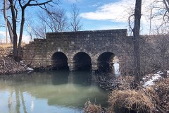 | Southeast Stone Arch Bridge - Lake Wabaunsee | 4.2 miles | 2009 |
| National Archives record | The nomination case file for reference 16000133 in Record Group 79. |
| Wabaunsee County | All 20 listed properties in this county. |