 Block
From the record
2 National Register listings published here.
Sources: the National Register database, National Park Service
12 topographic sheets cover 4 settlements here, and 2 properties are on the National Register of Historic Places.
2 National Register listings published here.
Sources: the National Register database, National Park Service
Every property in this county listed on the National Register of Historic Places, with the year it was listed and the federal nomination document.
| Photograph | Property | Type | Listed | Reference |
|---|---|---|---|---|
 | Clark-Robidoux House | building | 2001 | 01000406 |
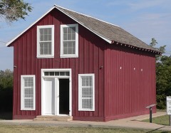 | Pond Creek Station | building | 1972 | 72000528 |
Every wildfire the federal occurrence database records inside this county: 3 of them, burning about 1,208 acres. None started naturally and none was recorded as arson. Each settlement page carries the fires within five miles of it.
| Reported cause | Fires |
|---|---|
| Equipment and vehicle use | 2 |
| Missing data/not specified/undetermined | 1 |
The five largest, by the area the report gives. None of them was recorded as arson.
| Date | Cause | Size | Reported by | Name on the report |
|---|---|---|---|---|
| 31 July 2006 | Missing data/not specified/undetermined | 1,107 acres | Wallace County | not named |
| 25 April 2018 | Equipment and vehicle use | 100 acres | Kansas Forest Service | 0W17011 |
| 14 March 2015 | Equipment and vehicle use | 1.0 acres | Kansas Forest Service | 1 |
Every settlement page carries the fires within five miles of it - see the settlement index below.
The NOAA Storm Events Database holds 655 reports for this county, causing no deaths, 4 injuries and about $6,961,000 in recorded property damage. Each settlement page carries the reports that name it.
| Kind of event | Reports |
|---|---|
| Hail | 382 |
| Thunderstorm Wind | 203 |
| Tornado | 45 |
| Flash Flood | 17 |
| Flood | 4 |
| Funnel Cloud | 2 |
| Lightning | 1 |
| Heavy Rain | 1 |
The most serious of them, by death, then injury, then recorded damage. The accounts are quoted exactly as the forecast office filed them.
| When | Event | Place named | Harm | What the report says |
|---|---|---|---|---|
| July 1958 | Tornado (F3) | not stated | 4 hurt, $25,000 | no account filed |
| August 1993 | Hail | Sharon Springs | $5,000,000 | Golfball-size hail damaged roofs and cars resulting in $1.2 milllion loss. |
| June 2011 | Thunderstorm Wind | Sharon Spgs Arpt | $488,000 | A small thunderstorm complex produced a long-swath of significant wind and hail damage across south-central into central Wallace county. The damage began near the Wallace-Greeley county border about 13 miles SSW of Sharon Springs, and continued to about 8 miles SSE of Wallace. Approximately 25 irrigation pivots were blown over, numerous grain bins were either damaged or destroyed, utility poles were broken, some outbuildings damaged and one semi-truck blown over. Some residences reported shingle damage and broken winds due to a combination of wind and hail. |
| March 2007 | Tornado (EF1) | Weskan | $250,000 | Tornado began 5 WSW of Tribune and continued into Wallace county, Kansas, crossing the county border near Road 10. EF0 damage occurred in Greeley county. After the tornado crossed into Wallace county, it damaged three unoccupied mobile/modular homes producing EF1 damage. The tornado continued to 3 S of Weskan before dissipating. Other minor damage occurred along the path, however no homes were affected. |
| August 2002 | Thunderstorm Wind | Sharon Spgs | $150,000 | Power poles down, 4 buildings at airport heavily damaged. |
| July 2023 | Thunderstorm Wind | Wallace | $100,000 | Two electric poles snapped, with atleast one more leaning. An old outbuilding, similiar in size to a single car garage, was blown a few feet off its foundation, and an irrigation pivot was overturned. |
| August 2002 | Thunderstorm Wind | Wallace | $100,000 | Fifteen empty rail cars overturned. Power lines down, grain bins overturned, significant damage to mobile home. |
| July 2023 | Thunderstorm Wind | Wallace | $80,800 | An outbuilding in farmyard was completely destroyed. Nearby a machine shed was also destroyed. Nearby a pine tree was snapped. |
| July 2023 | Thunderstorm Wind | Wallace | $80,000 | The tops of grain bins were bent inward. In addition the equipment attached to the grain bin was blown to the ground. |
| April 2015 | Thunderstorm Wind | Sharon Spgs | $65,000 | Two irrigation pivots were overturned, power lines blown down, dead trees uprooted and minor damage to two farm houses. Time estimated from Doppler radar. |
| April 2022 | Thunderstorm Wind | Wallace | $60,000 | As the line of storms moved over the town of Wallace, eight power poles were knocked down near the For Wallace Post Cemetery. |
| July 2011 | Thunderstorm Wind | Wallace | $55,000 | Newspaper reported strong winds which downed power poles and overturned pivots. A semi was also reported as being moved 60 feet and two combines were moved 30 feet. |
| August 2025 | Hail | Sharon Spgs Arpt | $50,000 | Various hail sizes noted in multiple photos with largest being baseball size. Some damage also occurred to travel trailer and a barn. |
| July 2008 | Thunderstorm Wind | Sharon Spgs | $50,000 | An intense microburst caused extensive damage to a localized area just south and east of Sharon Springs in Wallace county. Car ports were damaged and numerous 4-5 inch diameter tree branches were broken. Utility poles were broken about 3 miles east of Sharon Springs, and a shop building was heavily damaged. An unanchored mobile home was overturned and small wind-driven hail broke a few windows. |
| May 2006 | Hail | Sharon Spgs | $50,000 | Broken windshields and heavy body damage to three vehicles. A camper was also heavily damaged. Hail broke through roof of garage. Some livestock injured. |
| March 2000 | Thunderstorm Wind | Weskan | $50,000 | Farm equipment storage building and shed destroyed from straight-line winds. |
| September 1996 | Flash Flood | Wallace | $50,000 | no account filed |
| July 2023 | Thunderstorm Wind | Wallace | $30,000 | Semi with trailer loaded with bales pushed 100 yards due to wind. A nearby grain bin that was partially full was blown off its foundation to the east. In a nearby pasture a combine was pushed roughly a quarter mile from north to south. ||Just to the northwest a stock trailer was rolled roughly 100 yards into a pasture, up hill, a piece of a small livestock shed hit a pickup truck, rolling the truck on its side, and a thousand gallon fuel tank was rolled a quarter mile. |
| April 2022 | Thunderstorm Wind | Wallace | $30,000 | Three power poles reported down. |
| September 2019 | Thunderstorm Wind | Wallace | $30,000 | COOP observer sustained damage at their property due to a strong wind gust from outflow from a thunderstorm. Location is estimated to be near Wallace and time is estimated to be around 5 PM MST. Pictures from their property show a mobile home mostly destroyed with its roof blown off and multiple outer walls lacking integrity. Pictures also show substantial damage to a shed with its roof missing. |
| June 2018 | Thunderstorm Wind | Sunland | $30,000 | Thunderstorm winds blew an empty grain bin off its foundation and into another bin. |
| August 1992 | Tornado (F0) | not stated | $25,000 | no account filed |
| June 2019 | Thunderstorm Wind | Sharon Spgs | $20,000 | Tree fell on a truck. |
| September 2005 | Thunderstorm Wind | Weskan | $19,000 | Nine power poles down 1 mile south and 2 east of Weskan. Numerous large tree branches down. 4.30 inches of rain resulted in nuisance flooding. |
| August 2018 | Thunderstorm Wind | Sharon Spgs | $14,200 | Public sent pictures of a tree uprooted and down in a yard onto the road. Large trees and power poles snapped in Sharon Springs, as well as damage to a covered patio and fence. Structural material torn off building and blown against a home. |
| May 2023 | Flood | Weskan | $10,000 | A small barn was damaged due to flooding from heavy rainfall. The amount of rainfall was unknown. |
| July 2008 | Thunderstorm Wind | Wallace | $10,000 | An old garage just south of Wallace was blown over. |
| July 2015 | Thunderstorm Wind | Weskan | $7,500 | Large elm trees were blown down, including one of the trees being uprooted. A larger tree by the creek, with a diameter of 2.5 to 3 feet, was also uprooted. |
| July 2016 | Thunderstorm Wind | Sharon Spgs | $5,000 | Estimated time of report. A carport was tossed from a backyard up onto neighbor's roof and poked a hole in the roof. |
| May 1995 | Hail | Johnson | $5,000 | no account filed |
| August 2014 | Hail | Weskan | $3,000 | Golf ball to hen egg size hail occurred near Weskan. The hail broke a few windows and cracked siding on a residence. |
| August 2002 | Thunderstorm Wind | Sharon Spgs | $3,000 | Roof damage. Power poles down. |
| September 1976 | Tornado (F1) | not stated | $2,500 | no account filed |
| June 1968 | Tornado (F0) | not stated | $2,500 | no account filed |
| August 2020 | Thunderstorm Wind | Sharon Spgs | $2,000 | Report received via Facebook of a chimney blown off an old house. Wind gusts are estimated to be 80 mph and associated with an outflow boundary ahead of a linear cluster of thunderstorms. |
| May 2010 | Thunderstorm Wind | Weskan | $2,000 | Power lines down 5.5 miles north of Weskan. A cottonwood tree was also blown down. |
| April 2007 | Tornado (EF1) | Sharon Spgs | $2,000 | Power poles broken near Road X and Road 26. Otherwise, no known damage as the tornado was over open fields. Tornado began near Roads O, 22 and dissipated near Roads Z, 27. |
| July 2022 | Thunderstorm Wind | Wallace | $1,000 | Report received via social media of a approximately 12 inch diameter large tree limb broken off from a large tree. Time is estimated from radar and wind speed is estimated from damage indicators. |
| May 2010 | Hail | Weskan | $750 | A tractor windshield was broken due to large hail. |
| May 2008 | Hail | Wallace | $750 | Spotter reported hail breaking the windows. |
| August 2002 | Thunderstorm Wind | Sharon Spgs | $500 | Numerous windows broken in town. |
| June 1994 | Thunderstorm Wind | Sharon Springs | $500 | Thunderstorm winds broke seven to eight inch diameter branches. |
| May 1993 | Hail | Wallace | $500 | Thunderstorm winds associated with the thunderstorm blew tin off building. Funnel clouds were also reported with this storm. |
| August 2023 | Thunderstorm Wind | Sharon Spgs | $250 | Tree limbs of 4 inches in diameter downed from a pear tree at location by thunderstorm wind gust. Wind speed estimated from damage indicator. |
| August 2023 | Thunderstorm Wind | Sharon Spgs Arpt | $250 | One inch tree branch reported downed at location due to thunderstorm wind gust. Wind speed estimated from damage indicator. |
| April 2025 | Hail | Wallace | - | Report of golf ball sized hail, with photos, from local Emergency Manager. |
| April 2025 | Hail | Wallace | - | Spotter reported dime to penny sized hail covering the ground. |
| June 2025 | Thunderstorm Wind | Weskan | - | AWN site Section 22 reported a 64 mph wind gust. |
| June 2025 | Thunderstorm Wind | Sharon Spgs | - | Law enforcement reported an estimated 80 MPH gust. |
| June 2025 | Hail | Weskan | - | Report of 1 inch hail from MPing. |
| June 2025 | Thunderstorm Wind | Sharon Spgs | - | Wunderground site KKSSHARO30 reported the gust associated with outflow from decaying storm. |
| June 2025 | Thunderstorm Wind | Weskan | - | Weather Link site Section 32 reported a 71 mph wind gust. |
| June 2025 | Thunderstorm Wind | Weskan | - | Weather link site Farm Location reported a 59 mph wind gust. |
| June 2025 | Thunderstorm Wind | Sunland | - | Kansas State Mesonet, Wallace site reported a 69 MPH gust. |
| June 2025 | Thunderstorm Wind | Weskan | - | Spotter report of 64 MPH gust. |
| July 2025 | Thunderstorm Wind | Weskan | - | The mesonet site KKSWESKA9 measured the 72 mph wind gust. |
| July 2025 | Thunderstorm Wind | Sunland | - | The mesonet site named Wallace on the Kansas Mesonet measured the 59 mph wind gust. |
| July 2025 | Thunderstorm Wind | Sharon Spgs Arpt | - | The mesonet site CW6099 reported the wind gust. |
| July 2025 | Thunderstorm Wind | Weskan | - | CWOP site gw6138 recorded a 63 MPH gust. |
| July 2025 | Thunderstorm Wind | Sharon Spgs Arpt | - | Site C6099 reported 59 mph wind gust. |
Named settlements recorded in the Geographic Names Information System, each with the topographic sheets covering it. Villages, hamlets and abandoned places alike. Each is shown with the nearest named watercourse or landform and the survey quadrangle it falls on.
Sharon Springs township · 67758 · Sharon Springs West quadrangle
9 sheets, 1955 to 1985