 Block
From the record
2 National Register listings published here.
Sources: the National Register database, National Park Service
14 topographic sheets cover 5 settlements here, and 2 properties are on the National Register of Historic Places.
2 National Register listings published here.
Sources: the National Register database, National Park Service
Every property in this county listed on the National Register of Historic Places, with the year it was listed and the federal nomination document.
| Photograph | Property | Type | Listed | Reference |
|---|---|---|---|---|
| Municipal Auditorium and City Hall | building | 2019 | 100003427 | |
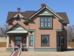 | William B. and Julia Washington House | building | 2014 | 14000351 |
Every wildfire the federal occurrence database records inside this county: 11 of them, burning about 3,326 acres. 2 started naturally and none was recorded as arson. Each settlement page carries the fires within five miles of it.
| Reported cause | Fires |
|---|---|
| Missing data/not specified/undetermined | 5 |
| Natural | 2 |
| Equipment and vehicle use | 2 |
| Debris and open burning | 1 |
| Recreation and ceremony | 1 |
The five largest, by the area the report gives. None of them was recorded as arson.
| Date | Cause | Size | Reported by | Name on the report |
|---|---|---|---|---|
| 21 January 2020 | Missing data/not specified/undetermined | 1,800 acres | Wichita County | K-25 AND RD 17 |
| 26 June 2012 | Missing data/not specified/undetermined | 1,200 acres | Kansas Counties | WICHITA COUNTY GRASS |
| 14 April 2017 | Equipment and vehicle use | 130 acres | Wichita County | 11 |
| 20 June 2017 | Natural | 100 acres | Wichita County | 18 |
| 7 November 2020 | Missing data/not specified/undetermined | 50 acres | Kansas Forest Service | not named |
| 3 March 2017 | Equipment and vehicle use | 40 acres | Wichita County | 5 |
| 9 March 2017 | Missing data/not specified/undetermined | 3.0 acres | Wichita County | 7 |
| 31 January 2020 | Recreation and ceremony | 2.0 acres | Kansas Forest Service | not named |
Every settlement page carries the fires within five miles of it - see the settlement index below.
The NOAA Storm Events Database holds 484 reports for this county, causing no deaths, 5 injuries and about $2,684,470 in recorded property damage. Each settlement page carries the reports that name it.
| Kind of event | Reports |
|---|---|
| Hail | 328 |
| Thunderstorm Wind | 102 |
| Tornado | 37 |
| Flash Flood | 13 |
| Heavy Rain | 2 |
| Flood | 2 |
The most serious of them, by death, then injury, then recorded damage. The accounts are quoted exactly as the forecast office filed them.
| When | Event | Place named | Harm | What the report says |
|---|---|---|---|---|
| May 1968 | Tornado (F3) | not stated | 4 hurt, $25,000 | no account filed |
| April 2022 | Hail | Leoti | 1 hurt | Multiple reports of hail associated with second storm that moved through Leoti. Hail ranged in size from half-dollar to baseball in size over a duration of 10 minutes. Hail busted windows in a home and damaged a car. There was one injury where someone was hit in the head by the large hail while retrieving a dog stuck outside. |
| May 1999 | Hail | Leoti | $800,000 | Hail broke out windows in house. |
| May 1999 | Hail | Leoti | $800,000 | no account filed |
| July 2023 | Thunderstorm Wind | Marienthal | $285,000 | Damage from the straight-line winds were surveyed along N County Road 20 from north of E County Road J to just south of E County Road L. Damage included three irrigation pivots turned over, the top of a mature tree snapped off, the top of two grain bins was damage along with augers going to five grain bins being damaged, the sliding doors being blown in on two metal machine sheds and another sliding door being blown out, along with a couple sheets of tin on the roof being blown loose and a hole being punched through the side of one of them, minor gutter damage to a house, a small shed was completely destroyed and single car garage was blown completely off its foundation. |
| June 1999 | Tornado (F3) | Leoti | $250,000 | A large tornado (F3) destroyed a farmstead. The house was nearly flattened by the tornado, and a tractor and grain combine/harvester were rolled several hundred feet. Tornado moved from East to West. |
| July 2023 | Thunderstorm Wind | Marienthal | $120,000 | Damage was reported along E County Road H from the intersection of N County Road 19 to N County Road 20. Damage included an small, old grain bin being blown off its foundation, a pole barn style garage being completely destroyed, the wooden cross member and top of an electric line being broken off, a small shed being completely destroyed, the roof of a machine shed nearly completely removed, and two other pole barn style machine sheds being completely destroyed. Near the location of one of the machine sheds an antenna tower was bent, leaning against a building next to the tower. |
| July 2008 | Thunderstorm Wind | Leoti | $100,000 | A feed yard northwest of Leoti, KS suffered damage from strong thunderstorm outflows. About 20% of the feed warehouse roof was removed. Two smaller wood-frame metal-skin sheds were heavily damaged. Four by eight foot hay bales were blown a short distance. Three irrigation pivots just south of the feed yard were overturned. All debris was blown from SSW to NNE. |
| July 2023 | Thunderstorm Wind | Marienthal | $70,000 | Irrigation pivot turned over. |
| May 1996 | Tornado (F1) | Leoti | $50,000 | no account filed |
| July 2020 | Thunderstorm Wind | Leoti | $25,000 | Report received of 5 power poles broken on the NW side of town due to thunderstorm wind gusts. Time is radar estimated and estimated wind gust speed is based on storm damage. |
| July 1956 | Tornado (F2) | not stated | $25,000 | no account filed |
| June 1951 | Tornado (F2) | not stated | $25,000 | no account filed |
| June 1950 | Tornado (F1) | not stated | $25,000 | no account filed |
| August 2021 | Thunderstorm Wind | Lydia | $15,000 | Wichita County Dispatch relayed an officer report of near zero visibility due to blowing dust caused by winds with an estimated peak gust of 100 mph. The strong winds were able to snap a power pole at mile marker 106 along Kansas Highway 25. |
| July 2011 | Thunderstorm Wind | Selkirk | $15,000 | An open ended shed was destroyed and thrown NNE. A damage survey by the emergency manager, and Doppler radar, indicated the damage was the result of a thunderstorm downburst. |
| April 2022 | Thunderstorm Wind | Selkirk | $10,000 | Straight-line winds knocked a grain bin trailer onto another farm vehicle and also ripped off portions of a metal barn wall. |
| July 1999 | Thunderstorm Wind | Leoti | $10,000 | Door blown in on west end of building. Numerous windows broken at school. |
| July 2023 | Thunderstorm Wind | Marienthal | $5,000 | Empty tanks from part of an oil tank battery were blown a quarter mile or more from their original location. The empty tanks were found at the beginning and end of the damage path. |
| May 2010 | Tornado (EF1) | Marienthal | $5,000 | This tornado developed on the east edge of town on Grand Street and moved northeast. A shed was destroyed, but no injuries were reported. |
| July 1994 | Hail | Leoti | $5,000 | Hail broke windshields. |
| May 1993 | Hail | Selkirk | $5,000 | Hail driven by wind damaged windows, vehicles, and wheat. |
| May 1993 | Hail | Leoti | $5,000 | Baseball-size hail damaged paint and roof. |
| May 2013 | Thunderstorm Wind | Marienthal | $2,000 | Trees down, garden shed blown over and a TV tower down on the east side of Marienthal. |
| May 2009 | Hail | Marienthal | $2,000 | Hail size is estimated. Wind driven hail damaged siding on a house and broke two windows. |
| April 2022 | Thunderstorm Wind | Leoti | $1,000 | A small metal office building had the metal roof partially peeled up by the strong thunderstorm wind gusts. |
| September 2021 | Thunderstorm Wind | Leoti | $1,000 | Report received of an estimated 70 mph wind gust near this location that downed a 1.25-inch diameter tree limb and blew off some old shingles from a roof. Event time is radar-estimated. Wind speed has been estimated based on storm damage. |
| June 2018 | Thunderstorm Wind | Leoti | $1,000 | A carport was blown down. |
| March 1998 | Hail | Leoti | $1,000 | Hail combined with wind broke windows. |
| July 2021 | Thunderstorm Wind | Lydia | $500 | Caller reported estimated 50 to 70 mph winds that lasted for a duration of 10 minutes as a supercell thunderstorm moved over the location. The strong winds were able to snap three inch diameter tree branches off of trees on the property. |
| September 2014 | Hail | Lydia | $500 | Ground completely covered the ground. Hail damage to gutter. Time estimated by radar. |
| May 1951 | Tornado (F1) | not stated | $250 | no account filed |
| May 2017 | Hail | Marienthal | $200 | Ping-pong to tea cup size hail was reported. The hail damaged a screen door on the house. |
| May 2021 | Flash Flood | St Theresa | $10 | Wichita County law enforcement reported water over KS Highway 25 at Hackberry Creek estimated to be at least six inches deep. Law enforcement barricaded the highway along the creek due to the high amount of water over the road. |
| July 2021 | Hail | Lydia | $10 | no account filed |
| May 2025 | Hail | Marienthal | - | A public report of nickel size hail was reported. |
| April 2025 | Hail | Leoti | - | Wichita County EM passed along a report of pea to dime sized hail in Leoti. |
| April 2025 | Hail | Leoti | - | Law enforcement reported dime sized hail 1 mile south of Leoti. |
| June 2025 | Thunderstorm Wind | Leoti | - | Emergency manager reports a microburst with broken poles and downed tree limbs around 6 inches in diameter. |
| June 2025 | Thunderstorm Wind | Leoti | - | Mesonet station FW1490 Leoti measured 71 mph wind gust. |
| June 2025 | Thunderstorm Wind | Leoti | - | Wind gusts estimated around 60 mph was reported by a spotter to the east of Leoti. |
| June 2025 | Thunderstorm Wind | Bird City Arpt | - | The AWOS at the Leoti Airport (K3K7) reported a 67 mph wind gust. |
| May 2025 | Hail | Lydia | - | Report if 1 inch hail. |
| May 2025 | Hail | St Theresa | - | Sheriff reported golf ball to tennis ball sized hail along Highway 25. |
| May 2025 | Hail | St Theresa | - | Emergency manager relayed a report of hail up to ping pong ball in size. |
| July 2025 | Thunderstorm Wind | Leoti | - | Kansas mesonet site reported the 64 mph wind gust. A 60 mph wind gust was reported just before the 64 mph gust. |
| July 2025 | Thunderstorm Wind | Marienthal | - | Ambient Weather site LeeSimons reported the wind gust. |
| May 2024 | Hail | Lydia | - | Pea to penny size hail reported but mostly dime size hail fell. |
| April 2024 | Hail | Leoti | - | Report via social media with photos of estimated racquet ball sized spikey hail near Leoti. |
| April 2024 | Hail | Leoti | - | Public submitted photo of nickel sized hail in Leoti. |
| April 2024 | Hail | St Theresa | - | Report with photo via social media of hail up to 2 1/2 inch. |
| April 2024 | Hail | St Theresa | - | Trained spotter reported 1-1.75 inch hail reported. |
| April 2024 | Hail | St Theresa | - | Trained spotter reports inch to 1.5 inch hail. |
| May 2024 | Hail | Lydia | - | Trained spotter reports golf ball sized hail with heavy rain and about 25 MPH wind gusts. Falling hail did shrink to 1 inch by 19 minutes after the hour. |
| April 2024 | Hail | Leoti | - | Report via MPing. |
| April 2024 | Thunderstorm Wind | Marienthal | - | Measured mesonet gust of 60 MPH. |
| April 2024 | Hail | Leoti | - | Trained spotter reports 1 inch hail. |
| July 2024 | Hail | St Theresa | - | Most of the hail was dime size, with some quarter size hail mixed in; lasted 5-10 minutes. Very windy but could not estimate the wind speed. |
| June 2024 | Hail | Lydia | - | Pea to 0.75 inch hail fell over a duration of 10 minutes. |
| June 2024 | Thunderstorm Wind | Marienthal | - | Reported via mesonet station KKSLEOTI31 near Marienthal. |
Named settlements recorded in the Geographic Names Information System, each with the topographic sheets covering it. Villages, hamlets and abandoned places alike. Each is shown with the nearest named watercourse or landform and the survey quadrangle it falls on.