 Block
From the record
One of 48 National Register listings published here for Dickinson County · listed in 2000 · category: Building.
Sources: the National Register database, National Park Service · the Wikipedia article
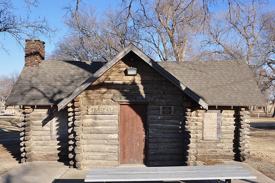
Listed on the National Register of Historic Places in 2000.
One of 48 National Register listings published here for Dickinson County · listed in 2000 · category: Building.
Sources: the National Register database, National Park Service · the Wikipedia article
Regional context, not property-specific evidence. The federal wildfire occurrence database lists 21 fires within 5 miles of Brewer Scout Cabin between 2015 and 2018, burning about 614 acres in total. None started naturally. 1 was recorded as arson. Distance is straight-line from the map coordinates, so a fire counted here may appear on a neighbouring settlement's page as well.
| Reported cause | Fires |
|---|---|
| Debris and open burning | 13 |
| Missing data/not specified/undetermined | 6 |
| Equipment and vehicle use | 1 |
| Arson/incendiarism | 1 |
The most recent of them, most recent first, with the day each was reported and the service that recorded it.
| Date | Cause | Size | Reported by | Name on the report |
|---|---|---|---|---|
| 3 July 2018 | Debris and open burning | 1.0 acres | Kansas Forest Service | 63 |
| 21 July 2018 | Equipment and vehicle use | 20 acres | Kansas Forest Service | 72 |
| 10 April 2017 | Arson/incendiarism | under an acre | Saline County | 38 |
| 4 March 2017 | Missing data/not specified/undetermined | 1.0 acres | Dickinson County | 34 |
| 4 March 2017 | Missing data/not specified/undetermined | under an acre | Dickinson County | 38 |
| 28 March 2015 | Debris and open burning | under an acre | Kansas Forest Service | 41 |
| 28 March 2015 | Debris and open burning | 75 acres | Kansas Forest Service | 39 |
| 28 March 2015 | Debris and open burning | 75 acres | Kansas Forest Service | 40 |
Regional context, not property-specific evidence. The National Weather Service names Solomon, the town this property stands in, in 40 storm reports between 1995 and 2026: 19 hail, 14 thunderstorm wind, 4 flood, 2 flash flood. The reports record 5 injuries. Each account below is quoted exactly as the forecast office filed it, from the NOAA Storm Events Database, and each date opens the federal record of that event.
| When | Event | Place named | Harm | What the report says |
|---|---|---|---|---|
| May 2016 | Tornado (EF4) | Solomon | 5 hurt | The long track violent tornado began 1-2 miles NNE of Niles Kansas and destroyed 2 homes in Ottawa county before crossing into Dickinson county north of Solomon. The tornado tracked 2-3 miles north of the city of Abilene following a meandering path approximately east along 2700 avenue in Dickinson county before veering southeast and crossing interstate 70 approx. 2 miles west of the city of Chapman. The tornado then moved ESE and then east along a path around 1 mile south of Chapman destroying 1 farmstead and several other homes in the area. The worst damage was done to a farmstead 1 mile southwest of Chapman along old highway 40 where the home was destroyed and all outbuildings were blown away. The sub floor of the home was removed from a bolted sill plate and the poured concrete foundation was cracked on the south side exposing the rebar where the strongest forces from the lifting structure occurred as it was being removed and blown away likely occurred. Much of the brick facade of the home did remain where it fell around the structure however so the area was not swept clean. Winds approaching 200 mph were likely in this area while a woman home at the time took shelter in the basement and was ok with only superficial injuries. The approximate number of minor injuries was 5 reported to NWS however none required a hospital visit. Photos of the damage are available off of the NWS damage assessment toolkit website at https://apps.dat.noaa.gov/StormDamage/DamageViewer/ . |
| May 2007 | Flood | Solomon | $400,000 | Solomon River is out of banks. Road between Solomon and Abilene impassable. Smoky Hill river at Enterprise floods. Sandbagging is done in the cities of Abilene, Chapman and Solomon due to flooding along the Solomon and Smoky Hill Rivers. |
| May 2007 | Flood | Solomon | $400,000 | Rain road/State highway 206 closed one mile north of Chapman. Vehicles are stranded in Chapman with sandbagging and some evacuations made. Moderate or greater flooding on the Smoky Hill river through Abilene and Enterprise with widespread lowland flooding that closes some roads. |
| May 2007 | Flash Flood | Solomon | $300,000 | Reports of three feet of water running across roads in the town of Solomon. Also, a report of 1 to 2 feet of water cross highway 40 at Daisy road. |
| May 2007 | Flash Flood | Solomon | $100,000 | Reports of three feet of water running across roads in the town of Solomon. Also, a report of 1 to 2 feet of water cross highway 40 at Daisy road. |
| June 1995 | Thunderstorm Wind | Solomon | $5,000 | no account filed |
| July 1996 | Thunderstorm Wind | Solomon | $1,000 | no account filed |
| June 2025 | Thunderstorm Wind | Solomon | - | The report was relayed via social media. Downed tree of unknown diameter and power outage was reported. |
| May 2024 | Hail | Solomon | - | Quarter size hail east of Solomon. |
| June 2022 | Thunderstorm Wind | Solomon | - | Report of large tree down. |
| June 2022 | Thunderstorm Wind | Solomon | - | Social media photo of 6 inch tree limb down. |
| May 2020 | Hail | Solomon | - | EM reported golf ball size hail. |
| June 2014 | Thunderstorm Wind | Solomon | - | Numerous tree limbs around 3 inches in diameter down. |
| June 2014 | Thunderstorm Wind | Solomon | - | There were several 3 to 4 inch diameter tree branches down. |
| March 2011 | Hail | Solomon | - | This was a delayed report. The time was estimated from radar. |
| June 2011 | Thunderstorm Wind | Solomon | - | The public reported a 60 mph wind gust near Solomon. |
| April 2010 | Flood | Solomon | - | Roads in Solomon were closed due to high water. |
| August 2009 | Thunderstorm Wind | Solomon | - | National Weather Service Personnel conducted a storm survey of Dickinson County following the storm's passage through the area. The strongest part of the storm passed through the county during the late morning. The first damage report from the county came into the office at 1040 CST. As the storm moved through the county it produced a wide swath of damage approximately 10 miles wide. Numerous powerlines were snapped from the strong winds. For the immediate few hours after the storm passed through Dickinson county every north-south thoroughfare was blocked by the downed power lines. Spotters who had fairly extensive damage done to their property estimated the winds at 90 to 100 mph. Several outbuildings were completely destroyed by the wind. Several houses sustained minor damage to the exterior from high winds and small hail. |
| July 2009 | Thunderstorm Wind | Solomon | - | This was a delayed report. |
| April 2026 | Hail | Solomon | - | no account filed |
| April 2025 | Hail | Solomon | - | no account filed |
| May 2018 | Hail | Solomon | - | no account filed |
| April 2016 | Hail | Solomon | - | no account filed |
| June 2013 | Hail | Solomon | - | no account filed |
| February 2007 | Hail | Solomon | - | no account filed |
| May 2003 | Hail | Solomon | - | no account filed |
| August 2003 | Thunderstorm Wind | Solomon | - | no account filed |
| August 2003 | Hail | Solomon | - | no account filed |
| August 2003 | Hail | Solomon | - | no account filed |
| July 2003 | Thunderstorm Wind | Solomon | - | no account filed |
| April 2002 | Hail | Solomon | - | no account filed |
| April 2002 | Hail | Solomon | - | no account filed |
| April 2001 | Hail | Solomon | - | no account filed |
| April 2001 | Thunderstorm Wind | Solomon | - | no account filed |
| September 2001 | Thunderstorm Wind | Solomon | - | no account filed |
| September 2001 | Hail | Solomon | - | no account filed |
| May 2000 | Hail | Solomon | - | no account filed |
| May 2000 | Hail | Solomon | - | no account filed |
| May 2000 | Hail | Solomon | - | no account filed |
| November 1996 | Flood | Solomon | - | no account filed |
No historic map-sheet match is published for this property yet. That does not mean no map exists. This record needs a coordinate-quality review before it can be joined to a sheet boundary. Browse the county's mapped places while that work is pending.
Other National Register properties close enough to walk or drive between, ordered by distance from this one. Both positions come from the same geocoding pass that matched these properties to their map sheets.
| Photograph | Property | Distance | Listed |
|---|---|---|---|
| Abilene City Park Historic District | 7.7 miles | 2002 | |
 | Mead-Rogers House | 7.8 miles | 2000 |
 | C. H. Lebold House | 7.9 miles | 1973 |
| Vine Street Historic District | 7.9 miles | 2018 |
| National Archives record | The nomination case file for reference 00000770 in Record Group 79. |
| Wikipedia article | Community-written account of this property, licensed CC BY-SA. |
| Dickinson County | All 48 listed properties in this county. |