BlockBefore
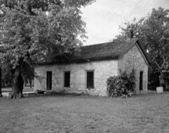
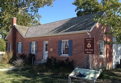
Photograph of Council Grove Missouri, Kansas and Texas Depot
Photograph by Art davis, CC BY-SA 3.0. Via Wikimedia Commons.

Council Grove Missouri, Kansas and Texas Depot

Listed on the National Register of Historic Places in 2001.

From the record

“The Council Grove Missouri, Kansas and Texas Depot is a former Missouri-Kansas-Texas Railroad (MKT) station at 512 E. The station opened on December 31, 1894, to replace the previous station, a utilitarian building which opened with the MKT line through Council Grove in 1869 and had burned down on May 18 of that year.”

Wikipedia article Council Grove station, CC BY-SA 4.0.

One of 27 National Register listings published here for Morris County · listed in 2001 · category: Building.

Sources: the Wikipedia article · the National Register database, National Park Service

The listing

  • What is counted as historic. The nomination lists 1 building as contributing to the listing.
  • Address. 512 E. Main St., Council Grove, 66846
  • When was it listed? October 2001
  • Category. building
  • Also known as. Railroad Resources of Kansas MPS
  • City. Council Grove city
  • National Register reference number. 01001092 - assigned by the National Park Service when the property was listed.

Fires near this property

19 since 2015

Regional context, not property-specific evidence. The federal wildfire occurrence database lists 19 fires within 5 miles of Council Grove Missouri, Kansas and Texas Depot between 2015 and 2018, burning about 174 acres in total. None started naturally. None was recorded as arson. Distance is straight-line from the map coordinates, so a fire counted here may appear on a neighbouring settlement's page as well.

Reported cause Fires
Missing data/not specified/undetermined18
Equipment and vehicle use1

The most recent of them, most recent first, with the day each was reported and the service that recorded it.

DateCause SizeReported by Name on the report
19 September 2015Missing data/not specified/undetermined1.0 acresKansas Forest Service2015051
10 June 2015Missing data/not specified/undetermined1.0 acresKansas Forest Service2015033
21 April 2015Missing data/not specified/undetermined2.0 acresKansas Forest Service2015027
10 April 2015Missing data/not specified/undetermined15 acresKansas Forest Service2015022
7 March 2015Missing data/not specified/undetermined1.0 acresKansas Forest Service2015014
31 March 2015Missing data/not specified/undetermined90 acresKansas Forest Service2015023
21 March 2015Missing data/not specified/undetermined1.0 acresKansas Forest Service2015017
18 March 2016Missing data/not specified/undeterminedunder an acreKansas Forest Service8

Every fire recorded in Morris County

Storms near this property

60 of 86 shown

Regional context, not property-specific evidence. The National Weather Service names Council Grove, the town this property stands in, in 86 storm reports between 1994 and 2024: 41 hail, 27 thunderstorm wind, 9 flash flood, 4 flood. The reports record 1 death. Each account below is quoted exactly as the forecast office filed it, from the NOAA Storm Events Database, and each date opens the federal record of that event.

WhenEvent Place namedHarm What the report says
May 1996Flash FloodCouncil Grove1 killed, $30,000no account filed
May 1995HailCouncil Grove$500,000Large hail produced extensive damage across the county including both property and crop. Many roofs, vehicles and windows were broken or damaged.
May 2007Flash FloodCouncil Grove$50,000Water reported flowing over sections of road between 500 block and 1200 block. Also on Main Street.
May 2007FloodCouncil Grove$50,000Widespread lowland flooding immediate reach of the gage near Dunlap due to moderate or greater flooding of the Neosho River.
August 2005Flash FloodCouncil Grove$50,000Fast flowing water over roads with small streams out of banks. Rainfall of five to seven inches produced flash flooding.
July 1994Thunderstorm WindCouncil Grove$50,000Winds estimated to 80 mph caused widespread and significant damage in Council Grove, nearby Council Grove Reservoir and across much of the county. Trees, power lines, signs, boats, marina and homes were all damaged in various degrees. Power was out in many areas for 12 to 18 hours.
May 1998Thunderstorm WindCouncil Grove$30,000no account filed
June 2005Heavy RainCouncil Grove$20,000Ponding of water and small stream flooding along U.S. Highway 177 near Council Grove.
June 2004Thunderstorm WindCouncil Grove$20,000Strong winds destroyed a metal grain elevator.
September 2010Thunderstorm WindCouncil Grove$3,000A large tree was blown down. a barn was moved three feet from foundation. Large empty fuel barrels rolled away.
March 2007Flash FloodCouncil Grove$1,000Six to eight inches of water flowing over Rural Roads K and 500.
May 2005Flash FloodCouncil Grove$1,000Up to 6 inches of rain caused flash flooding with rapid flow over rural roads around Council Grove.
July 1996Thunderstorm WindCouncil Grove$1,000no account filed
July 1996LightningCouncil Grove$500no account filed
May 2024HailCouncil Grove-Report relayed by kvoe radio.
April 2020HailCouncil Grove-Golf ball sized hail covered the ground.
May 2015FloodCouncil Grove-Minor flooding of low areas on Dunlap rd at big John creek. Other minor flooding noted throughout Morris county.
September 2015Thunderstorm WindCouncil Grove-Several 6 to 10 inch diameter tree branches down.
July 2014Thunderstorm WindCouncil Grove-Tree limbs up to 6 inches in diameter down.
July 2014Thunderstorm WindCouncil Grove-Wind gusts estimated.
July 2013Thunderstorm WindCouncil Grove-Tree limbs with 1 to 2 inch diameter down. Wind gusts estimated around 50 to 60 mph.
May 2013Thunderstorm WindCouncil Grove-Damage to a home and an out building was destroyed on old K4.
March 2012HailCouncil Grove-This was a delayed report, discovered on social media.
June 2008Thunderstorm WindCouncil Grove-Large trees reported to have blown down.
June 2008HailCouncil Grove-Hail the size of quarters began to fall, and quickly increased in size to three and a half inches in diameter.
September 2007Thunderstorm WindCouncil Grove-Trained spotter was driving car along Hwy 56, approximately 2 miles east of Council Grove. Also reported dime size hail.
March 2007Tornado (EF0)Council Grove-This narrow tornado was rated EF0. It snapped a power pole and broke some tree limbs near the intersection of Q and 400 roads. In addition to some tree damage at this location...outbuildins were damaged. A three sided pole shed was destroyed...a weak barn was shifted on its foundation and a wind mill tower was toppled. The tornado formed from a supercell thunderstorm. The tornado was on the ground for 2.8 miles and averaged 20 yards wide.
April 2006HailCouncil Grove-Measured at Council Grove Lake.
August 2006Thunderstorm WindCouncil Grove-2 inch diameter tree limbs reported down.
June 2004Flash FloodCouncil Grove-Heavy rain produced flash flooding with 8 inches of water over a road.
July 2004Flash FloodCouncil Grove-Heavy rains produced flash flooding in Morris county. Streets were reported flooding in Council Grove and water was reported to be moving swiftly over highway 4 near Dwight.
June 2004Flash FloodCouncil Grove-Heavy rains produced flash flooding that washed out a ditch and pushed boulders onto a highway. A road was also closed near Council Grove due to high water.
June 1995HailCouncil Grove-A tornado struck a pickup throwing the driver into a nearby ditch. The truck was found about one-quarter mile away with the engine about 200 yards from the remains of the nearly destroyed truck chassis. The driver sustained severe injuries and required at least 30 stitches. The driver had barbed wire and clothing wrapped around his legs and body. He crawled to a nearby road where he was able to stand and walk. He was found by a passing motorist and taken to a local hospital where he remained for several days. The tornado also damaged nearby buildings, silos, and farm equipment. The tornado was reportedly moving northwest.
May 2018HailCouncil Grove-no account filed
August 2014HailCouncil Grove-no account filed
March 2012HailCouncil Grove-no account filed
April 2011HailCouncil Grove-no account filed
February 2011HailCouncil Grove-no account filed
March 2009HailCouncil Grove-no account filed
April 2008HailCouncil Grove-no account filed
June 2006Thunderstorm WindCouncil Grove-no account filed
August 2006Thunderstorm WindCouncil Grove-no account filed
July 2005Thunderstorm WindCouncil Grove-no account filed
June 2005HailCouncil Grove-no account filed
June 2005Thunderstorm WindCouncil Grove-no account filed
July 2005Thunderstorm WindCouncil Grove-no account filed
June 2004Thunderstorm WindCouncil Grove-no account filed
March 2002HailCouncil Grove-no account filed
May 2002HailCouncil Grove-no account filed
September 2002HailCouncil Grove-no account filed

Every storm recorded in Morris County

Map coverage status

No historic map-sheet match is published for this property yet. That does not mean no map exists. This record needs a coordinate-quality review before it can be joined to a sheet boundary. Browse the county's mapped places while that work is pending.

Listed places nearby

6 within 8 miles

Other National Register properties close enough to walk or drive between, ordered by distance from this one. Both positions come from the same geocoding pass that matched these properties to their map sheets.

Photograph PropertyDistance Listed
Council Grove Historic District0.3 miles1966
Madonna of the Trail0.4 miles2018
US Post Office-Council Grove0.4 miles1989
Seth Hays House0.5 miles1975
Farmers and Drovers Bank0.5 miles1971
Cottage House Hotel0.5 miles1988

Sources for this property

National Archives recordThe nomination case file for reference 01001092 in Record Group 79.
Wikipedia articleCommunity-written account of this property, licensed CC BY-SA.
Morris CountyAll 27 listed properties in this county.

Provenance

  • Listing record. National Park Service National Register of Historic Places, listed-properties dataset, current to 2026-05-22.
  • Map join. Address geocoded through the United States Census geocoder, then tested against the published boundary of every sheet in the USGS Historical Topographic Map Collection.
  • How this page is made. Listing fields come from federal records; map-sheet coverage is a labelled coordinate-to-boundary calculation, not a source-field claim.
  • Wildfire. Short, Karen C. 2022. Spatial wildfire occurrence data for the United States, 1992-2020 [FPA_FOD_20221014]. 6th Edition. Fort Collins, CO: Forest Service Research Data Archive. https://doi.org/10.2737/RDS-2013-0009.6 Collected with United States Government funding and usable without additional permissions or fees.
  • Storms. NOAA National Centers for Environmental Information, Storm Events Database https://www.ncei.noaa.gov/stormevents/ A work of the United States government, no copyright under 17 U.S.C. 105. Narratives are quoted verbatim from the National Weather Service report and are not edited or summarised.