
BlockBefore
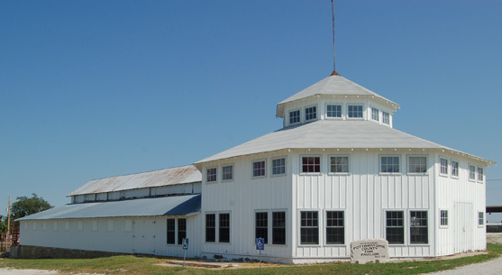
Photograph of Pottawatomie County Fair Pavilion
Photograph by PowercatPark, CC BY-SA 3.0. Via Wikimedia Commons.

Pottawatomie County Fair Pavilion

Built in 1921. Listed on the National Register of Historic Places in 2004.

From the record

“The Pottawatomie County Fair Pavilion, at the Pottawatomie County fairgrounds in Onaga, Kansas, was built in 1921. It was listed on the National Register of Historic Places in 2004.”

Wikipedia article Pottawatomie County Fair Pavilion, CC BY-SA 4.0.

One of 14 National Register listings published here for Pottawatomie County · listed in 2004 · category: Building · built in 1921.

Sources: the Wikipedia article · the National Register database, National Park Service

The listing

  • What is counted as historic. The nomination lists 1 building as contributing to the listing.
  • Address. East Ninth St., Onaga, 67669
  • When was it listed? January 2004
  • Category. building
  • When was it built? 1921
  • National Register reference number. 03001499 - assigned by the National Park Service when the property was listed.

Storms near this property

22 since 1996

Regional context, not property-specific evidence. The National Weather Service names Onaga, the town this property stands in, in 22 storm reports between 1996 and 2009: 13 hail, 3 thunderstorm wind, 3 flash flood, 2 tornado. No death or injury is recorded in these reports. Each account below is quoted exactly as the forecast office filed it, from the NOAA Storm Events Database, and each date opens the federal record of that event.

WhenEvent Place namedHarm What the report says
May 2007Flash FloodOnaga$10,000Water over many rural roads due to heavy rainfall.
July 2001Thunderstorm WindOnaga$2,000Strong winds blew the roof off a shed several hundred feet.
May 2005Flash FloodOnaga$1,000Torrential rains brought about 6 inches of fast flowing water across roads in the area.
May 2000LightningOnaga$1,000Lightning did minor damage to a home near Onaga.
June 2008Tornado (EF2)Onaga-This is the first segment of an EF-2 tornado that began in Pottawatomie County, moved northeast into Jackson County and continued northeast into Nemaha County before dissipating. This is segment 1 of 3 for the tornado path. In Pottawatomie County the tornado touched down near a farmstead south of Havensville and compromised some of the external walls of a residence as well as tearing a large portion of the roof off of the residence. Extensive damage was noted to outbuildings and trees near the residence. The tornado continued northeast damaging mainly rural areas of northeastern Pottawatomie County damaging trees and power poles.
April 2006Tornado (F0)Onaga-Law enforcement reported a brief tornado touchdown at 4:48 pm cst 2 miles east of Onaga. The tornado caused no damage. It was an F0 tornado with a path width of 50 yards or less and was on the ground for a tenth of a mile. The tornado formed from a parent supercell thunderstorm.
June 1999Flash FloodOnaga-Flash flooding resulted from heavy rains. A man was rescued from a vehicle that became stalled in flood waters 5 miles south of Onaga. Flash flooding also occurred in Wamego and other locations in the county doing extensive crop damage and flooding several roads and businesses.
March 2009HailOnaga-no account filed
June 2008HailOnaga-no account filed
April 2006HailOnaga-no account filed
May 2005HailOnaga-no account filed
June 2004HailOnaga-no account filed
November 2003HailOnaga-no account filed
July 2003HailOnaga-no account filed
August 2001Thunderstorm WindOnaga-no account filed
April 1999HailOnaga-no account filed
August 1999HailOnaga-no account filed
August 1997Thunderstorm WindOnaga-no account filed
June 1997HailOnaga-no account filed
June 1996HailOnaga-no account filed

Every storm recorded in Pottawatomie County

Map coverage status

No historic map-sheet match is published for this property yet. That does not mean no map exists. This record needs a coordinate-quality review before it can be joined to a sheet boundary. Browse the county's mapped places while that work is pending.

Sources for this property

National Archives recordThe nomination case file for reference 03001499 in Record Group 79.
Wikipedia articleCommunity-written account of this property, licensed CC BY-SA.
Pottawatomie CountyAll 14 listed properties in this county.

Provenance

  • Listing record. National Park Service National Register of Historic Places, listed-properties dataset, current to 2026-05-22.
  • Map join. Address geocoded through the United States Census geocoder, then tested against the published boundary of every sheet in the USGS Historical Topographic Map Collection.
  • How this page is made. Listing fields come from federal records; map-sheet coverage is a labelled coordinate-to-boundary calculation, not a source-field claim.
  • Storms. NOAA National Centers for Environmental Information, Storm Events Database https://www.ncei.noaa.gov/stormevents/ A work of the United States government, no copyright under 17 U.S.C. 105. Narratives are quoted verbatim from the National Weather Service report and are not edited or summarised.