 Block
From the record
14 National Register listings published here.
Sources: the National Register database, National Park Service
61 topographic sheets cover 19 settlements here, and 14 properties are on the National Register of Historic Places.
14 National Register listings published here.
Sources: the National Register database, National Park Service
Every property in this county listed on the National Register of Historic Places, with the year it was listed and the federal nomination document.
| Photograph | Property | Type | Listed | Reference |
|---|---|---|---|---|
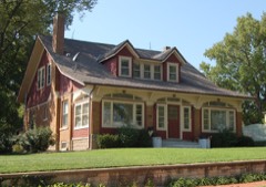 | Cassius and Adelia Baker House | building | 2013 | 13000433 |
| Genn Hospital | building | 2025 | 100012465 | |
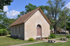 | German Evangelical Church | building | 2018 | 100001949 |
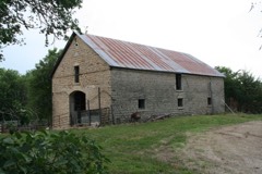 | Joseph Heptig Barn | building | 2011 | 11000728 |
 | John McKimmons Barn | building | 2010 | 10000178 |
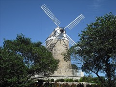 | Old Dutch Mill | structure | 1973 | 73000773 |
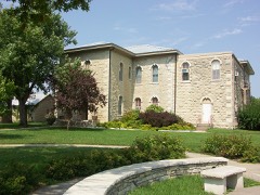 | Pottawatomie County Courthouse | building | 2018 | 100001950 |
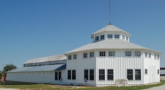 | Pottawatomie County Fair Pavilion | building | 2004 | 03001499 |
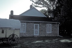 | Pottawatomie Indian Pay Station | building | 1972 | 72000521 |
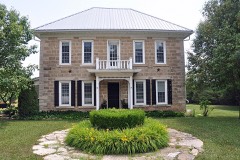 | Teske Farmstead | building | 2009 | 09000193 |
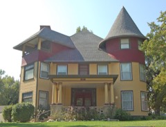 | George and Virginia Trout House | building | 2014 | 13001043 |
| Vermillion Creek Crossing, Oregon Trail | site | 1975 | 75000720 | |
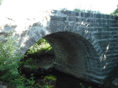 | Vermillion Creek Tributary Stone Arch Bridge | structure | 1986 | 86003354 |
| Verschelden Funeral Home | building | 2025 | 100012439 |
Every wildfire the federal occurrence database records inside this county: 211 of them, burning about 29,121 acres. None started naturally and 19 were recorded as arson. Each settlement page carries the fires within five miles of it.
| Reported cause | Fires |
|---|---|
| Missing data/not specified/undetermined | 85 |
| Debris and open burning | 74 |
| Arson/incendiarism | 19 |
| Equipment and vehicle use | 12 |
| Smoking | 10 |
| Fireworks | 6 |
| Power generation/transmission/distribution | 3 |
| Misuse of fire by a minor | 2 |
The five largest, by the area the report gives. None of them was recorded as arson.
| Date | Cause | Size | Reported by | Name on the report |
|---|---|---|---|---|
| 3 April 2005 | Missing data/not specified/undetermined | 8,000 acres | Kansas Forest Service | OAKS |
| 7 April 2004 | Missing data/not specified/undetermined | 7,000 acres | Kansas Forest Service | KRAUSE |
| 15 March 2014 | Missing data/not specified/undetermined | 4,000 acres | Pottawatomie County | SHANNON CREEK |
| 3 April 2005 | Missing data/not specified/undetermined | 1,500 acres | Kansas Forest Service | FLINT ROCK |
| 14 April 2006 | Missing data/not specified/undetermined | 934 acres | Kansas Counties | KRAUSE 2 |
| 15 April 2006 | Missing data/not specified/undetermined | 800 acres | Kansas Counties | HOOD GRASS |
| 4 March 2009 | Missing data/not specified/undetermined | 650 acres | Fort Riley Kansas | SCREEN RANGE |
| 2 April 2005 | Missing data/not specified/undetermined | 600 acres | Kansas Forest Service | CLEBURNE PARK |
Every settlement page carries the fires within five miles of it - see the settlement index below.
The NOAA Storm Events Database holds 744 reports for this county, causing no deaths, 8 injuries and about $9,107,550 in recorded property damage. Each settlement page carries the reports that name it.
| Kind of event | Reports |
|---|---|
| Hail | 408 |
| Thunderstorm Wind | 255 |
| Tornado | 37 |
| Flash Flood | 28 |
| Lightning | 9 |
| Flood | 3 |
| Heavy Rain | 3 |
| Funnel Cloud | 1 |
The most serious of them, by death, then injury, then recorded damage. The accounts are quoted exactly as the forecast office filed them.
| When | Event | Place named | Harm | What the report says |
|---|---|---|---|---|
| October 1979 | Tornado (F2) | not stated | 5 hurt, $250,000 | no account filed |
| June 1985 | Thunderstorm Wind | not stated | 2 hurt | no account filed |
| March 1996 | Thunderstorm Wind | Manhattan | 1 hurt, $50,000 | no account filed |
| July 1994 | Thunderstorm Wind | Countywide | $5,000,000 | Winds clocked to 99 mph at the Jeffrey Power Plant near Emmett, and estimated to between 65 and 100 mph elsewhere caused widespread and severe damage across the entire county. Numerous trees, roofs, windows and power lines were damaged or destroyed from the high wind. Power was out in many areas for more than 48 hours. At the Jeffrey Power Plant, 33 empty rail cars were blown from off the track with coal loading machinery and buildings damaged. The plant had to briefly shut down. Damage to the plant was estimated at $2 to $2.5 million. Heavy rain accompanied the storm and flooded some areas. Cleanup continued for days. Total dollar loss for the county, including the Jeffrey Plant, was $4 to $5 million. |
| March 1993 | Tornado (F1) | to 4 N | $500,000 | A small tornado cut a broken path about four miles long causing spotty damage to several buildings, a truck bed manufacturing business and some greenhouses. The damage was estimated at $200,000. |
| May 1993 | Tornado (F1) | Wheaton | $500,000 | The tornado moved through the northern part of the county causing damage at nine different locations. Most damage was to outbuildings and barns although three homes were damaged in Duluth along with numerous utility poles and cable. The tornado had multiple vortices at times. |
| June 2005 | Tornado (F1) | Swamp Angel | $250,000 | Tornado occurred at the Elbo lake community east of Manhattan. Many large trees were damaged or blown over...powerlines were downed...a boat blown across the lake and at least four buildings sustained damage...primarily from trees falling on them. |
| March 1990 | Tornado (F1) | not stated | $250,000 | no account filed |
| May 1978 | Tornado (F3) | not stated | $250,000 | no account filed |
| April 1976 | Tornado (F1) | not stated | $250,000 | no account filed |
| April 2002 | Thunderstorm Wind | Wamego | $227,000 | Strong winds damaged many homes and residences in Wamego. |
| July 1998 | Lightning | St George | $218,000 | no account filed |
| May 2007 | Flash Flood | St George | $200,000 | Near Green Valley road at approximately the 4200 block on highway 24...drainage ditches full and spilling over onto the roadways. Water approaching highway 24 about 1/4 mile further east as well. County roads were flooded and some damaged. Some homes damaged by flood waters in the lake Elbo area. |
| May 2007 | Flash Flood | Wamego | $150,000 | Water around one foot deep flowing over several streets in the city of Wamego. Nearly 5 inches of rain fell. One intersection noted was 99th and Lincoln. A number of homes and garages were flooded. Rural roads were water covered with some damaged. A section of railroad track was also washed out. |
| October 2005 | Flash Flood | St Marys | $150,000 | Highway 24 under at least 6 inches of fast flowing water. |
| June 2005 | Flash Flood | St Marys | $100,000 | Over 6 inches of fast flowing water across several roads in the area. |
| June 2005 | Heavy Rain | St George | $80,000 | A four inch downpour brought small stream and urban flooding with some sandbagging along Blackjack Creek on the west side of St. George. |
| July 2007 | Flash Flood | St George | $70,000 | Basement wall in newly constructed home buckled when water flowed up against the foundation. Up to 5 inches of rain fell. Blackjack road was barricaded and closed due to high water. |
| May 1998 | Thunderstorm Wind | Olsburg | $60,000 | no account filed |
| March 1996 | Thunderstorm Wind | Belvue | $60,000 | no account filed |
| May 2007 | Flash Flood | Flush | $50,000 | Officially, four to six inches of rain with locally nearly 7.75 inches in less than four hours led to flash flooding over central and southwest Pottawatomie county. One unofficial amount of nearly 12.5 inches was noted in a newspaper report. There was enough force from the running water to pull hedge posts buried over 3 and a half feet out of the ground on one homestead. Several area roads were closed and parts of the Flush road were washed out. | |
| May 2007 | Flood | Louisville | $50,000 | Moderate or greater flooding of Rock Creek in the vicinity of Louisville and the Kansas River in the vicinity of Wamego. Some lowland flooding and a few county roads closed. |
| June 2005 | Lightning | Wamego | $50,000 | Lightning hit feeder lines to the Wamego Municipal Power Plant with some damage to the plant and loss of power to some residents. |
| September 1993 | Hail | Blaine | $50,000 | A slow moving supercell thunderstorm moved northwest to southeast across much of Pottawatomie County during the early afternoon. Numerous reports of large hail and winds of 55 to 65 knots were common with the storm. Heavy rainfall also caused minor low land flooding. A large well defined rotating wall cloud produced two small brief tornadoes that will be discussed separately. |
| July 2003 | Thunderstorm Wind | St George | $25,000 | Strong winds downed power poles near St. George. |
| May 1980 | Tornado (F1) | not stated | $25,000 | no account filed |
| June 1965 | Tornado (F2) | not stated | $25,000 | no account filed |
| June 1965 | Tornado (F1) | not stated | $25,000 | no account filed |
| June 2007 | Heavy Rain | St Marys | $20,000 | A storm spotter measured 3.10 inches of rain in St. Mary's. Lowland flooding was occurring with ponding of water on some roads. |
| July 2003 | Thunderstorm Wind | Belvue | $20,000 | Strong winds downed power poles near Belvue. |
| June 1998 | Hail | Wamego | $15,000 | no account filed |
| June 2007 | Flash Flood | Wamego | $10,000 | Water reported to be running over Hwy 24. Numerous county roads also reported to be flooded and impassible on the north side of Wamego, including Hwy 99 between Wamego and Louisville where one foot of water was observed to be flowing over the roadway. |
| May 2007 | Flash Flood | Onaga | $10,000 | Water over many rural roads due to heavy rainfall. |
| May 1998 | Thunderstorm Wind | St George | $9,000 | no account filed |
| August 2010 | Thunderstorm Wind | Flush | $8,000 | Strong thunderstorms brought periods of strong winds and heavy rain to portions of Pottawatomie County on the afternoon of Aug 10, 2010. These storms produced strong winds which broke or damaged 6 power poles near a landfill along Wheaton Road near Louisville. The Kansas Department of Transportation reported a roof was torn off a barn-style metal shed located near Highway 24 and Onaga Road. Many spotters throughout the area reported 60 to 70 mph winds with this storm. |
| May 1998 | Thunderstorm Wind | Wheaton | $8,000 | no account filed |
| March 2002 | Thunderstorm Wind | Westmoreland | $7,000 | Strong winds blew part of the roof off of a trailer home. |
| August 2000 | Thunderstorm Wind | St Marys | $7,000 | Strong winds overturned a semi in St Marys. Power lines and trees were also downed. Many businesses suffered damage. |
| July 2011 | Thunderstorm Wind | Blaine | $5,000 | Three large diameter power poles were reported down west of Wheaton. |
| April 2002 | Thunderstorm Wind | Wamego | $5,000 | Strong winds damaged some homes in Wamego. |
| June 1994 | Thunderstorm Wind | Westmoreland | $5,000 | Winds hit 77 mph at the Jeffrey Energy power plant. |
| June 1994 | Thunderstorm Wind | St Marys | $5,000 | Winds hit 77 mph at the Jeffrey Energy power plant. |
| June 1994 | Thunderstorm Wind | St. Marys | $5,000 | High winds knocked down trees, tree limbs, and power lines in and around St Marys. |
| May 1998 | Thunderstorm Wind | Wamego | $5,000 | no account filed |
| July 2004 | Thunderstorm Wind | Emmett | $4,000 | Strong winds blew down a power line. |
| August 2000 | Thunderstorm Wind | Wamego | $4,000 | Strong winds did roof damage to 2 homes in Wamego. The same storm damaged the corn crop near Wamego as well. |
| August 2004 | Thunderstorm Wind | Wamego | $3,000 | Strong winds damaged power poles. |
| August 2004 | Thunderstorm Wind | Wamego | $3,000 | Strong winds blew down some power lines. |
| April 2002 | Thunderstorm Wind | Wamego | $3,000 | Strong winds damaged some business signs in Wamego. |
| October 2002 | Thunderstorm Wind | Wamego | $3,000 | Strong winds blew a bin over and did some damage to it. |
| August 2000 | Thunderstorm Wind | Emmett | $3,000 | Strong thunderstorm winds did numerous damage to glass at the Jeffrey Energy Center. |
| October 1979 | Tornado (F0) | not stated | $2,500 | no account filed |
| May 1951 | Tornado | not stated | $2,500 | no account filed |
| May 1951 | Tornado (F1) | not stated | $2,500 | no account filed |
| September 2010 | Thunderstorm Wind | Olsburg | $2,000 | The fire department garage door was pushed out along with part of the wall. The fire chief also reported large bales of hay that were pushed. |
| June 2010 | Thunderstorm Wind | Fostoria | $2,000 | Trained spotters and law enforcement officers reported 60 mph wind gusts near Westmoreland and St. George. In Olsburg trees were reported blown down. KDOT was required to use chainsaws to move the trees. |
| July 2001 | Thunderstorm Wind | Onaga | $2,000 | Strong winds blew the roof off a shed several hundred feet. |
| August 2000 | Thunderstorm Wind | Belvue | $2,000 | Trees and power lines were downed near Belvue. |
| May 1998 | Thunderstorm Wind | Olsburg | $2,000 | no account filed |
| August 2012 | Thunderstorm Wind | St George | $1,000 | A 12 inch diameter tree was blown down in St. George. |
The Survey's mineral resources record lists 2 workings inside this county. All of them still produce. Each settlement page carries the workings within five miles of it.
| Commodity | Workings |
|---|---|
| Stone, Crushed/Broken | 1 |
| Sand and Gravel, Construction | 1 |
The least common of them first, because a county's hundredth gravel pit says nothing its first ten did not.
| Where | Site | Commodity | Status | Recorded |
|---|---|---|---|---|
| Mc Carter Quarry | Stone, Crushed/Broken | Producer | ||
| Wamego Sand Dredge | Sand and Gravel, Construction | Producer |
Named settlements recorded in the Geographic Names Information System, each with the topographic sheets covering it. Villages, hamlets and abandoned places alike. Each is shown with the nearest named watercourse or landform and the survey quadrangle it falls on.
Grant township · 66432 · On Straight Creek · Havensville quadrangle
14 sheets, 1889 to 1986
Louisville township · 66547 · On Elm Slough · Louisville quadrangle
16 sheets, 1889 to 1990
St. Clere township · 66422 · On Big Noxie Creek · Emmett quadrangle
16 sheets, 1889 to 1990
St. George township · 66535 · On Blackjack Creek · Saint George quadrangle
18 sheets, 1889 to 1990
St. Marys township · 66536 · On Willard Creek · Saint Marys quadrangle
16 sheets, 1889 to 1990
Rock Creek township · 66549 · Near Mount Ephraim · Westmoreland quadrangle
17 sheets, 1889 to 1990