 Block
From the record
One of 17 National Register listings published here for Brown County · listed in 2004 · category: Structure.
Sources: the National Register database, National Park Service
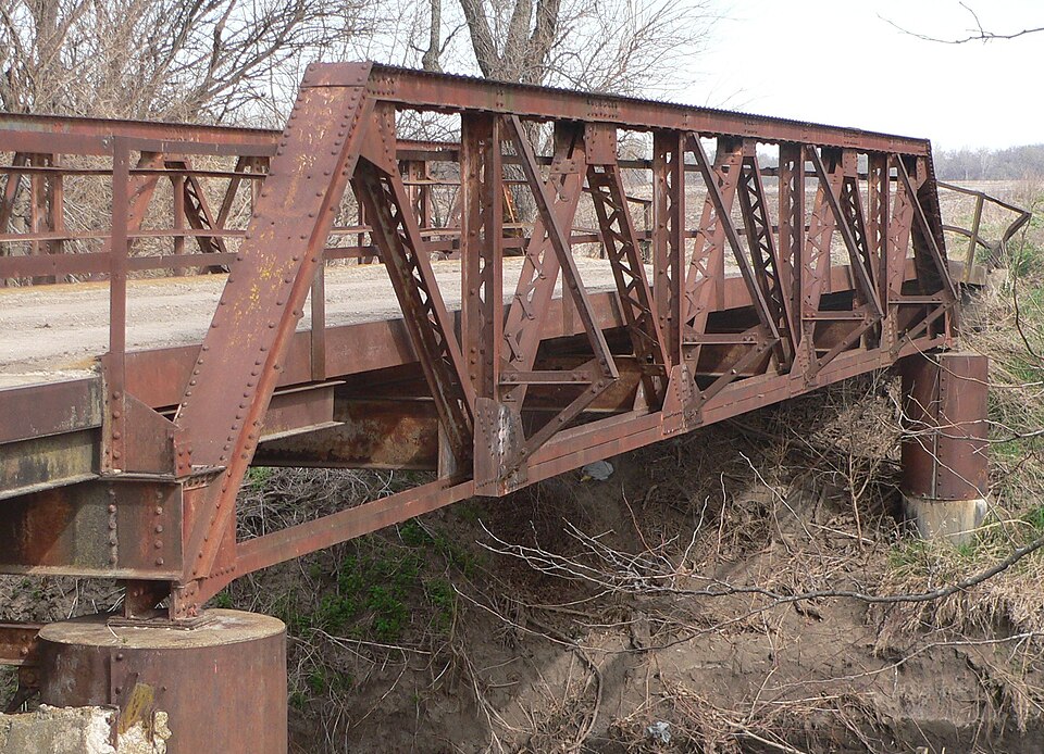
Listed on the National Register of Historic Places in 2004.
One of 17 National Register listings published here for Brown County · listed in 2004 · category: Structure.
Sources: the National Register database, National Park Service
Regional context, not property-specific evidence. The federal wildfire occurrence database lists 19 fires within 5 miles of Delaware River Warren Truss Bridge between 2005 and 2020, burning about 982 acres in total. None started naturally. 4 were recorded as arson. Distance is straight-line from the map coordinates, so a fire counted here may appear on a neighbouring settlement's page as well.
| Reported cause | Fires |
|---|---|
| Missing data/not specified/undetermined | 9 |
| Arson/incendiarism | 4 |
| Debris and open burning | 4 |
| Equipment and vehicle use | 1 |
| Smoking | 1 |
The most recent of them, most recent first, with the day each was reported and the service that recorded it.
| Date | Cause | Size | Reported by | Name on the report |
|---|---|---|---|---|
| 3 September 2015 | Missing data/not specified/undetermined | under an acre | Kansas Forest Service | 0015-47 |
| 1 August 2015 | Missing data/not specified/undetermined | under an acre | Kansas Forest Service | 0015-44 |
| 8 July 2015 | Arson/incendiarism | under an acre | Horton Agency | MASQUAT |
| 8 July 2015 | Arson/incendiarism | under an acre | Horton Agency | HILL |
| 24 May 2006 | Debris and open burning | 5.0 acres | Horton Agency | WENGER |
| 6 April 2018 | Debris and open burning | 3.0 acres | Kansas Forest Service | 2018029 |
| 6 April 2006 | Equipment and vehicle use | 1.0 acres | Horton Agency | GARCIA |
| 13 April 2018 | Missing data/not specified/undetermined | under an acre | Kansas Forest Service | 1800025 |
Regional context, not property-specific evidence. The National Weather Service names Fairview, the town this property stands in, in 40 storm reports between 1993 and 2024: 24 hail, 13 thunderstorm wind, 2 tornado, 1 flash flood. No death or injury is recorded in these reports. Each account below is quoted exactly as the forecast office filed it, from the NOAA Storm Events Database, and each date opens the federal record of that event.
| When | Event | Place named | Harm | What the report says |
|---|---|---|---|---|
| May 1993 | Tornado (F2) | Fairview | $500,000 | The tornado began near Highway 75 about eight miles south of Fairview and moved northnortheast damaging about half dozen farmsteads before dissipating southeast of Fairview. The tornado was not on the ground continuously along its path. Debris from the tornado was reported in the sky west of Hiawatha. |
| March 2006 | Tornado (F1) | Fairview | $150,000 | This F1 tornado crossed into Brown County from Nemaha County about 2.5 miles west-southwest of Fairview, where it damaged one farmstead. The path width was estimated to be 100 yards with the tornado being on the ground in Brown County for less than 1 mile. The damage in Brown County was estimated at $150,000. The tornado formed in a bow echo that produced an otherwise wide swath of wind damage. |
| April 1999 | Thunderstorm Wind | Fairview | $150,000 | no account filed |
| July 1994 | Thunderstorm Wind | Fairview | $50,000 | High winds caused widespread tree, power line and some structural damage around most the county, especially western and southern sections. |
| September 2001 | Thunderstorm Wind | Fairview | $3,000 | Strong winds blew down 6 power poles near Fairview. |
| August 2012 | Hail | Fairview | $1,000 | Half dollar sized hail dented a car near Fairview. |
| June 2021 | Thunderstorm Wind | Fairview | - | Report of a house blown off of its foundation. |
| August 2019 | Flash Flood | Fairview | - | Small creeks out of banks and several roads flooding due to torrential rains. |
| May 2019 | Thunderstorm Wind | Fairview | - | One outbuilding destroyed. Powerlines were down. 0.5 miles east, an old abandoned house was damaged with large trees snapped. |
| July 2013 | Hail | Fairview | - | Delayed report. Hail ranged from dimes to quarters and was wind driven. Wind estimated around 40 to 50 mph. There was minor crop damage report to several crops in the area. Rainfall total for the storm was approx 1 inch. |
| June 2011 | Thunderstorm Wind | Fairview | - | A trained spotter near Fairview reported a 60 mph wind gust. |
| August 2010 | Thunderstorm Wind | Fairview | - | Trained spotters near Fairview reported 60 to 70 mph wind gusts. |
| June 2009 | Thunderstorm Wind | Fairview | - | A trained spotter reported a 60 mph wind gust. |
| August 2007 | Thunderstorm Wind | Fairview | - | A storage shed at the Holthaus Autohaus was demolished by thunderstorm winds. |
| August 2006 | Thunderstorm Wind | Fairview | - | A grain bin was blown onto a roadway, continued to roll, struck a power pole, and knocked down a tree according to newpaper reports. |
| June 2024 | Thunderstorm Wind | Fairview | - | no account filed |
| May 2019 | Hail | Fairview | - | no account filed |
| April 2017 | Hail | Fairview | - | no account filed |
| April 2016 | Hail | Fairview | - | no account filed |
| August 2013 | Hail | Fairview | - | no account filed |
| May 2013 | Hail | Fairview | - | no account filed |
| March 2012 | Hail | Fairview | - | no account filed |
| May 2011 | Hail | Fairview | - | no account filed |
| May 2011 | Hail | Fairview | - | no account filed |
| May 2011 | Hail | Fairview | - | no account filed |
| March 2009 | Hail | Fairview | - | no account filed |
| March 2009 | Hail | Fairview | - | no account filed |
| June 2009 | Hail | Fairview | - | no account filed |
| June 2005 | Hail | Fairview | - | no account filed |
| June 2004 | Hail | Fairview | - | no account filed |
| June 2003 | Hail | Fairview | - | no account filed |
| June 2003 | Hail | Fairview | - | no account filed |
| August 2003 | Thunderstorm Wind | Fairview | - | no account filed |
| July 2003 | Thunderstorm Wind | Fairview | - | no account filed |
| May 2002 | Hail | Fairview | - | no account filed |
| June 2001 | Hail | Fairview | - | no account filed |
| August 2001 | Hail | Fairview | - | no account filed |
| June 1998 | Hail | Fairview | - | no account filed |
| July 1997 | Hail | Fairview | - | no account filed |
| May 1996 | Hail | Fairview | - | no account filed |
No historic map-sheet match is published for this property yet. That does not mean no map exists. This record needs a coordinate-quality review before it can be joined to a sheet boundary. Browse the county's mapped places while that work is pending.
Other National Register properties close enough to walk or drive between, ordered by distance from this one. Both positions come from the same geocoding pass that matched these properties to their map sheets.
| Photograph | Property | Distance | Listed |
|---|---|---|---|
| Bank of Powhattan Building | 4.5 miles | 2025 |
| National Archives record | The nomination case file for reference 04000580 in Record Group 79. |
| Brown County | All 17 listed properties in this county. |