 Block
From the record
One of 21 National Register listings published here for Saline County · listed in 2004 · category: Structure · built in 1907.
Sources: the National Register database, National Park Service
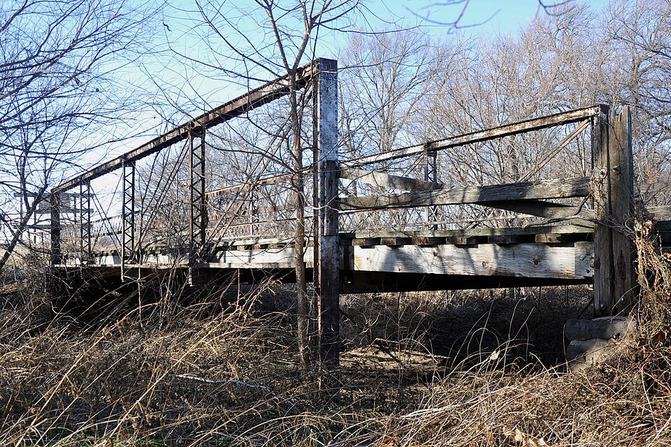
Built in 1907. Listed on the National Register of Historic Places in 2004.
One of 21 National Register listings published here for Saline County · listed in 2004 · category: Structure · built in 1907.
Sources: the National Register database, National Park Service
Regional context, not property-specific evidence. The federal wildfire occurrence database lists 3 fires within 5 miles of Hobbs Creek Truss Leg Bedstead Bridge between 2015 and 2018, burning about 85 acres in total. None started naturally. None was recorded as arson. Distance is straight-line from the map coordinates, so a fire counted here may appear on a neighbouring settlement's page as well.
| Reported cause | Fires |
|---|---|
| Missing data/not specified/undetermined | 1 |
| Equipment and vehicle use | 1 |
| Debris and open burning | 1 |
The most recent of them, most recent first, with the day each was reported and the service that recorded it.
| Date | Cause | Size | Reported by | Name on the report |
|---|---|---|---|---|
| 11 September 2017 | Debris and open burning | 80 acres | Saline County | 2017002 |
| 2 July 2018 | Equipment and vehicle use | 5.0 acres | Kansas Forest Service | 29895 |
| 29 October 2015 | Missing data/not specified/undetermined | under an acre | Kansas Forest Service | 8392 |
Regional context, not property-specific evidence. The National Weather Service names Gypsum, the town this property stands in, in 31 storm reports between 1995 and 2024: 17 hail, 6 thunderstorm wind, 4 flood, 2 flash flood. No death or injury is recorded in these reports. Each account below is quoted exactly as the forecast office filed it, from the NOAA Storm Events Database, and each date opens the federal record of that event.
| When | Event | Place named | Harm | What the report says |
|---|---|---|---|---|
| July 2019 | Flash Flood | Gypsum | $30,000 | Emergency management conducted water rescues across the northeast portion of Gypsum, due to flash flooding along the Gypsum Creek. |
| July 2019 | Flash Flood | Gypsum | $10,000 | Emergency management reported either to twelve water rescues in Gypsum and Kipp due to rising water. |
| July 2007 | Thunderstorm Wind | Gypsum | $3,000 | A power pole was downed at the intersection of 3rd and King, and 4-inch tree limbs were downed in and around Gypsum. Courtesy of The Salina Journal. |
| June 2022 | Flood | Gypsum | $100 | Water covered a portion of Kansas Highway 4 due to flooding. Most of the flood waters were associated with the swollen Gypsum Creek. |
| March 2024 | Hail | Gypsum | - | Pea to quarter sized hail was reported near Gypsum. Small hail was coating the ground. |
| May 2021 | Flood | Gypsum | - | Water was reported over Hobbs Creek road. |
| July 2020 | Heavy Rain | Gypsum | - | This is a 24 hour rainfall report of 3.97 inches. |
| May 2019 | Thunderstorm Wind | Gypsum | - | Reported by the mesonet site. |
| August 2019 | Thunderstorm Wind | Gypsum | - | This report was via the Kansas Mesonet. |
| June 2017 | Thunderstorm Wind | Gypsum | - | This was a measured wind speed. |
| June 2017 | Thunderstorm Wind | Gypsum | - | There were no reports of damage. |
| October 2016 | Tornado (EF3) | Gypsum | - | A manufactured double wide home which was held down by straps was completely lifted and destroyed. Additionally a jeep was rolled approximately 200 yards; there was damage to other farm equipment which was tossed from their original locations. Another homestead received significant tree damage along the path. All farm machinery was thrown across the property. Of significance was a combine that was rolled about 75 yards. |
| July 2013 | Flood | Gypsum | - | Water covered Kansas Highway 4 south of Gypsum. |
| July 2013 | Flood | Gypsum | - | The roads were closed near the intersection of Donmyer Road and Hobbs Creek Road due to flooding. |
| May 2010 | Hail | Gypsum | - | Report was from a KAKE Television chaser. |
| May 2010 | Hail | Gypsum | - | Report was from a KAKE Television chaser. |
| May 2010 | Hail | Gypsum | - | The hail covered the ground. |
| May 2010 | Hail | Gypsum | - | The hail covered the ground. |
| August 2003 | Hail | Gypsum | - | Radio station KSAL. |
| July 2023 | Thunderstorm Wind | Gypsum | - | no account filed |
| May 2019 | Hail | Gypsum | - | no account filed |
| June 2016 | Hail | Gypsum | - | no account filed |
| March 2009 | Hail | Gypsum | - | no account filed |
| March 2009 | Hail | Gypsum | - | no account filed |
| May 2005 | Hail | Gypsum | - | no account filed |
| June 2005 | Hail | Gypsum | - | no account filed |
| July 2003 | Hail | Gypsum | - | no account filed |
| May 2002 | Hail | Gypsum | - | no account filed |
| June 1999 | Hail | Gypsum | - | no account filed |
| May 1997 | Hail | Gypsum | - | no account filed |
| May 1995 | Hail | Gypsum | - | no account filed |
No historic map-sheet match is published for this property yet. That does not mean no map exists. This record needs a coordinate-quality review before it can be joined to a sheet boundary. Browse the county's mapped places while that work is pending.
| National Archives record | The nomination case file for reference 04001143 in Record Group 79. |
| Saline County | All 21 listed properties in this county. |