
BlockBefore
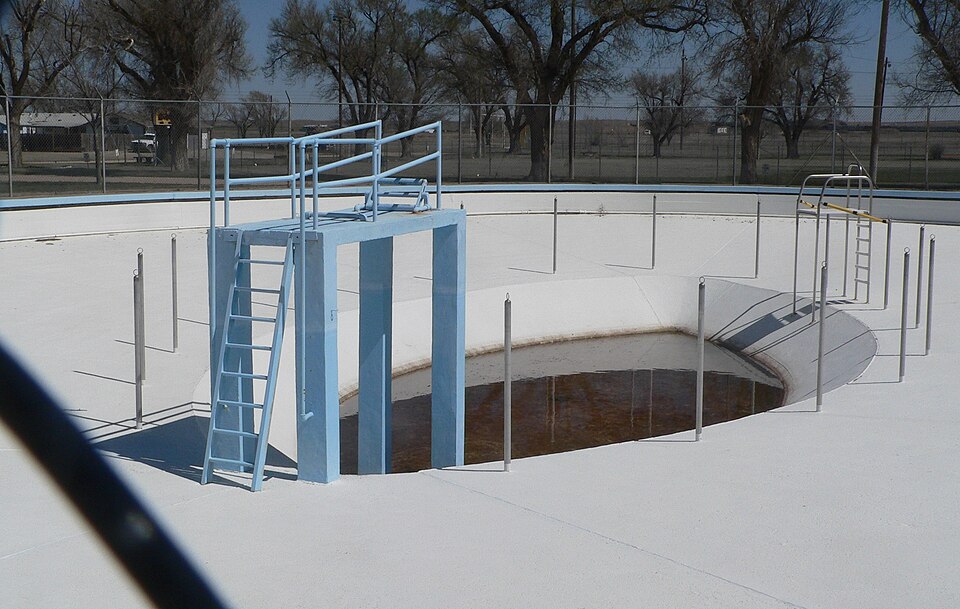
Photograph of Fowler Swimming Pool and Bathhouse
Photograph by Ammodramus, CC0 1.0. Via Wikimedia Commons.

Fowler Swimming Pool and Bathhouse

Built in 1936 (Moderne architecture). Listed on the National Register of Historic Places in 2009.

From the record

“The Fowler Swimming Pool and Bathhouse, located at 308 E. 6th in Fowler, Kansas, was built in 1936 by the Works Progress Administration, a New Deal work program. It includes an oval pool and a bathhouse designed in Moderne style architecture.”

Wikipedia article Fowler Swimming Pool and Bathhouse, CC BY-SA 4.0.

One of 3 National Register listings published here for Meade County · listed in 2009 · category: Building · built in 1936, Moderne architecture.

Sources: the Wikipedia article · the National Register database, National Park Service

The listing

  • What is counted as historic. The nomination lists 1 building, 1 structure as contributing to the listing.
  • Address. 308 E. 6th, Fowler, 67844
  • When was it listed? February 2009
  • Category. building
  • Also known as. New Deal-Era Resources of Kansas MPS
  • Township. Fowler township
  • When was it built? 1936
  • Architectural style. Moderne architecture
  • National Register reference number. 09000030 - assigned by the National Park Service when the property was listed.

Fires near this property

8 since 1999

Regional context, not property-specific evidence. The federal wildfire occurrence database lists 8 fires within 5 miles of Fowler Swimming Pool and Bathhouse between 1999 and 2020, burning about 2,635 acres in total. 1 started naturally. None was recorded as arson. Distance is straight-line from the map coordinates, so a fire counted here may appear on a neighbouring settlement's page as well.

Reported cause Fires
Missing data/not specified/undetermined7
Natural1

The most recent of them, most recent first, with the day each was reported and the service that recorded it.

DateCause SizeReported by Name on the report
10 August 2020Missing data/not specified/undetermined5.0 acresKansas Forest Servicenot named
17 July 2020Missing data/not specified/undetermined25 acresKansas Forest Servicenot named
17 June 2017Natural4.0 acresMeade County0FFD023
30 May 2018Missing data/not specified/undetermined1.0 acresKansas Forest Service503020
29 December 1999Missing data/not specified/undetermined2,000 acresMeade Countynot named
3 November 2020Missing data/not specified/undetermined600 acresMeade CountySEYFERT
9 October 2015Missing data/not specified/undeterminedunder an acreKansas Forest Service0FFD011
21 January 2017Missing data/not specified/undeterminedunder an acreMeade County0FFD004

Every fire recorded in Meade County

Storms near this property

60 of 119 shown

Regional context, not property-specific evidence. The National Weather Service names Fowler, the town this property stands in, in 119 storm reports between 1995 and 2023: 86 hail, 18 thunderstorm wind, 9 tornado, 2 funnel cloud. No death or injury is recorded in these reports. Each account below is quoted exactly as the forecast office filed it, from the NOAA Storm Events Database, and each date opens the federal record of that event.

WhenEvent Place namedHarm What the report says
May 2019Flash FloodFowler$1,000,000Rainfall of nearly 10 inches caused very severe flash flooding. Water came across highway 23 and washed an old concrete truck full of concrete across the highway and into an adjacent draw about 400 yards away. The drum of concrete had been there for decades. Also, water washed out a bridge and a resident of nearly 90 years had never seen so much water. The majority of the rain fell in a 3 hour period.
March 2007Tornado (EF1)Fowler$75,000This tornado damaged a shed and some trees west of Fowler and a pivot irrigation sprinkler northwest of Fowler. The tornado moved into Gray county at 752 PM CDT.
February 2007Tornado (EF1)Fowler$50,000The second tornado to form started 6.3 miles northwest of Fowler at 1011 PM and traveled a total of 17 miles dissipating at 1040 PM 7 miles southwest of the Dodge City Post Office. It did EF1 damage to five pivot irrigation sprinklers, trees and some outbuildings...in addition to moving a 3000 gallon tank about 1/2 of a mile. In Meade county it tipped over a pivot sprinkler before moving into Ford county at 1014 PM.
May 2020HailFowler-The hail was penny to quarter sized.
May 2019Tornado (EF0)Fowler-This was brief and intermittent tornado.
May 2019Heavy RainFowler-The rain gauge that holds 10 inches overflowed. There was severe flooding in the area.
May 2019HailFowler-Siding damage was indicated.
May 2019Heavy RainFowler-The 6 inch capacity rain gauge overflowed. Estimated 7 inches but it could have been more.
May 2015Flash FloodFowler-Flooding was reported in Fowler.
May 2015Tornado (EF2)Fowler-This tornado damaged high voltage transmission lines and poles, pivot irrigation sprinklers, a home and trees. A stock trailer was tossed through the side of the home but fortunately all occupants were in the basement. A car in the driveway was carried and then dropped in a field about 100 miles to the north-northeast. There were no roll marks from the vehicle. The tornado moved into Ford County.
August 2012Thunderstorm WindFowler-Winds were estimated to be 70 MPH.
August 2011Thunderstorm WindFowler-Winds were estimated to be 60 MPH.
June 2009HailFowler-Winds of 50 to 60 mph were also reported with the hail.
June 2009Thunderstorm WindFowler-Winds were estimated at 60 mph.
June 2009Funnel CloudFowler-A storm chaser reported a large cone shaped funnel almost 1/2 way to the ground.
May 2007Tornado (EF0)Fowler-A weak vortex existed for about a minute as it traveled west. The tornado was typical of what one would see in a tropical environment.
February 2007Tornado (EF0)Fowler-The first tornado started at 956 PM CST 8.5 miles west of Fowler in Meade county and traveled about 2.5 miles before dissipating at 1006 PM 7.5 miles northwest of Fowler. It did very minor damage to some trees.
June 2005Tornado (F1)Fowler-This tornado damaged a home, trees, power lines and several center pivot sprinklers. The forward flanking downdraft heavily damaged the Fowler high school roof.
June 2005Tornado (F1)Fowler-This satellite tornado traveled southwest striking a center pivot sprinkler.
July 2004Thunderstorm WindFowler-Six power poles were snapped off at the base
August 2002Tornado (F0)Fowler-A brief tornado formed but did not hit anything.
May 1998HailFowler-Hail completely covered the road.
June 2023Thunderstorm WindFowler-no account filed
June 2019HailFowler-no account filed
April 2017HailFowler-no account filed
June 2014HailFowler-no account filed
June 2013HailFowler-no account filed
May 2012HailFowler-no account filed
April 2012HailFowler-no account filed
May 2012HailFowler-no account filed
April 2012HailFowler-no account filed
April 2010HailFowler-no account filed
September 2010HailFowler-no account filed
June 2009HailFowler-no account filed
June 2008HailFowler-no account filed
April 2008HailFowler-no account filed
August 2007HailFowler-no account filed
July 2007HailFowler-no account filed
March 2007Funnel CloudFowler-no account filed
March 2007HailFowler-no account filed
July 2007HailFowler-no account filed
March 2007HailFowler-no account filed
August 2006HailFowler-no account filed
June 2006HailFowler-no account filed
September 2006HailFowler-no account filed
June 2005HailFowler-no account filed
July 2005HailFowler-no account filed
June 2004HailFowler-no account filed
July 2004HailFowler-no account filed
July 2004Thunderstorm WindFowler-no account filed

Every storm recorded in Meade County

Map coverage status

No historic map-sheet match is published for this property yet. That does not mean no map exists. This record needs a coordinate-quality review before it can be joined to a sheet boundary. Browse the county's mapped places while that work is pending.

Listed places nearby

1 within 8 miles

Other National Register properties close enough to walk or drive between, ordered by distance from this one. Both positions come from the same geocoding pass that matched these properties to their map sheets.

Photograph PropertyDistance Listed
Hotel Bunyan0.4 miles2025

Sources for this property

National Archives recordThe nomination case file for reference 09000030 in Record Group 79.
Wikipedia articleCommunity-written account of this property, licensed CC BY-SA.
Meade CountyAll 3 listed properties in this county.

Provenance

  • Listing record. National Park Service National Register of Historic Places, listed-properties dataset, current to 2026-05-22.
  • Map join. Address geocoded through the United States Census geocoder, then tested against the published boundary of every sheet in the USGS Historical Topographic Map Collection.
  • How this page is made. Listing fields come from federal records; map-sheet coverage is a labelled coordinate-to-boundary calculation, not a source-field claim.
  • Wildfire. Short, Karen C. 2022. Spatial wildfire occurrence data for the United States, 1992-2020 [FPA_FOD_20221014]. 6th Edition. Fort Collins, CO: Forest Service Research Data Archive. https://doi.org/10.2737/RDS-2013-0009.6 Collected with United States Government funding and usable without additional permissions or fees.
  • Storms. NOAA National Centers for Environmental Information, Storm Events Database https://www.ncei.noaa.gov/stormevents/ A work of the United States government, no copyright under 17 U.S.C. 105. Narratives are quoted verbatim from the National Weather Service report and are not edited or summarised.