 Block
From the record
One of 7 National Register listings published here for Pawnee County · listed in 2025 · category: Building.
Sources: the National Register database, National Park Service
Listed on the National Register of Historic Places in 2025.
One of 7 National Register listings published here for Pawnee County · listed in 2025 · category: Building.
Sources: the National Register database, National Park Service
Regional context, not property-specific evidence. The federal mineral resources record lists 2 workings within 5 miles of JG Edwards Building: 2 producers. All of them still produce. What was taken out: Sand and Gravel, Construction. Distance is straight-line from the map coordinates, so a quarry counted here may appear on a neighbouring settlement's page as well.
| Where | Site | Commodity | Status | Recorded |
|---|---|---|---|---|
| Eakin Sand and Gravel Co | Sand and Gravel, Construction | Producer | ||
| Larned Sand and Gravel | Sand and Gravel, Construction | Producer |
Regional context, not property-specific evidence. The National Weather Service names Larned, the town this property stands in, in 234 storm reports between 1993 and 2025: 140 hail, 75 thunderstorm wind, 8 heavy rain, 5 tornado. The reports record 1 injury. Each account below is quoted exactly as the forecast office filed it, from the NOAA Storm Events Database, and each date opens the federal record of that event.
| When | Event | Place named | Harm | What the report says |
|---|---|---|---|---|
| August 1996 | Thunderstorm Wind | Larned | 1 hurt, $3,200,000 | no account filed |
| May 1993 | Tornado (F1) | Larned | $500,000 | The tornado destroyed several farm buildings including sheds and grain bins. Seven center pivot irrigation systems were also destroyed. |
| May 1993 | Tornado (F0) | Larned | $500,000 | Tornado moved over open farmland and destroyed several irrigation systems. |
| May 1996 | Thunderstorm Wind | Larned | $250,000 | no account filed |
| August 2010 | Thunderstorm Wind | Larned | $100,000 | Damage at the Heritage Feeders was reported. There were many tall standing structures with some sort of damage, including the feed mill, concrete silo, sheds and concrete walls tipped over. |
| May 1999 | Hail | Larned | $100,000 | $100,000 in damage across the county. |
| August 2003 | Lightning | Larned | $80,000 | A house was hit by lightning and was completely destroyed |
| June 1999 | Thunderstorm Wind | Larned | $40,000 | Power poles down and pivot sprinkler overturned. |
| June 1999 | Thunderstorm Wind | Larned | $30,000 | Pivot sprinkler overturned and 18 inch diameter tree limb broken. |
| June 1998 | Thunderstorm Wind | Larned | $20,000 | A 40 by 80 foot shed was destroyed. |
| April 2006 | Thunderstorm Wind | Larned | $10,000 | Damage to Al Hanken Motors. Other areas of town had broken windows from an apparent Rear Flank Downdraft. |
| June 1998 | Thunderstorm Wind | Larned | $6,500 | Thirteen power poles blown down. |
| June 1999 | Thunderstorm Wind | Larned | $5,000 | Large tree limbs down. |
| June 1994 | Thunderstorm Wind | Larned | $5,000 | Grain bin blown apart. |
| August 2010 | Thunderstorm Wind | Larned | $2,000 | Road signs along highway 156 were blown down into adjacent fields. |
| April 2006 | Thunderstorm Wind | Larned | $1,000 | Lots of tree damage but perhaps not enough to justify the estimated 100 mph wind. |
| June 1999 | Thunderstorm Wind | Larned | $500 | Three inch diameter limbs down. |
| April 2025 | Hail | Larned | - | A public report for hail of 0.75 inches. |
| June 2025 | Thunderstorm Wind | Larned | - | A dead tree branch measuring 7 inches in diameter, was broken off. This wind damage report was received through social media. |
| August 2024 | Hail | Larned | - | Hail the size of quarters was reported by the public. |
| August 2024 | Hail | Larned | - | The public reported golf ball sized hail in Larned. |
| August 2024 | Hail | Larned | - | Hail measuring one and one half inches in diameter was reported by the public. |
| August 2024 | Thunderstorm Wind | Larned | - | A wind gust measured at 72 mph by a mesonet station in Larned. |
| August 2024 | Hail | Larned | - | Baseball sized hail was reported in Larned at 10:35 am. |
| June 2023 | Thunderstorm Wind | Larned | - | Tree limbs down, wire down. |
| June 2023 | Thunderstorm Wind | Larned | - | Tree limbs down. |
| July 2023 | Thunderstorm Wind | Larned | - | Strong winds. |
| July 2023 | Thunderstorm Wind | Larned | - | Three inch tree limbs broken and power poles broken in Larned. |
| October 2023 | Thunderstorm Wind | Larned | - | A tree was reported down in Larned due to thunderstorm winds. |
| June 2019 | Heavy Rain | Larned | - | Rainfall of 3.48 inches was measured. |
| June 2019 | Heavy Rain | Larned | - | Rainfall of 3.50 inches was measured. |
| April 2019 | Hail | Larned | - | Quarter to golf ball sized hail. |
| August 2019 | Thunderstorm Wind | Larned | - | There were multiple reports of large tree limbs blown down. |
| June 2018 | Thunderstorm Wind | Larned | - | There were many 4 inch diameter tree limbs blown down by the high wind. |
| July 2018 | Heavy Rain | Larned | - | Rainfall of 2.72 inches was recorded in about an hour. |
| July 2018 | Heavy Rain | Larned | - | Rainfall of 3.24 inches was measured in several hours. |
| September 2018 | Heavy Rain | Larned | - | Rainfall of 3.44 inches was observed. |
| September 2018 | Heavy Rain | Larned | - | Rainfall of 2.78 inches was observed. |
| October 2018 | Heavy Rain | Larned | - | Rainfall for the period was 4.0 inches. |
| April 2017 | Flash Flood | Larned | - | Water was reported over several county roads. |
| October 2017 | Thunderstorm Wind | Larned | - | Measured at the Larned middle school. |
| July 2016 | Flash Flood | Larned | - | Rainfall of 4.04 inches in less than 2 hours produced extensive flooding in and around Larned. Several vehicles stalled in the high water. |
| April 2015 | Thunderstorm Wind | Larned | - | Winds were estimated to be at least 60 MPH. |
| June 2014 | Thunderstorm Wind | Larned | - | A flat roof was ripped off a business on the west side of Larned. Also, a couple of 12 inch diameter tree limbs were blown down. |
| August 2014 | Thunderstorm Wind | Larned | - | Winds were estimated to be 60 MPH. |
| May 2013 | Hail | Larned | - | The hail was mostly dime to nickel sized. |
| August 2011 | Thunderstorm Wind | Larned | - | Nickel sized hail also fell with the high wind. |
| August 2011 | Hail | Larned | - | Wind gusts to 60 MPH accompanied the hail. |
| May 2011 | Thunderstorm Wind | Larned | - | Winds were estimated to be 60 MPH. There was also 1/2 inch diameter hail. |
| June 2010 | Heavy Rain | Larned | - | Rainfall of 5.80 was reported. |
| August 2010 | Thunderstorm Wind | Larned | - | There were numerous reports of damage in Larned with numerous large tree branches blown down and windows broken. |
| June 2008 | Hail | Larned | - | The hail was mostly pea sized. |
| October 2008 | Thunderstorm Wind | Larned | - | Three inch diameter tree limbs were blown down. |
| September 2007 | Thunderstorm Wind | Larned | - | Power lines were blown down and partial power outages were reported in Larned. |
| July 2007 | Thunderstorm Wind | Larned | - | Three large trees were blown over. |
| May 2007 | Flood | Larned | - | Water was over highways 56 and 156. |
| May 2007 | Flood | Larned | - | Streets were flooded with several stranded cars reported. 3.03 of rain fell in only 1 hour and 15 minutes. |
| April 2006 | Thunderstorm Wind | Larned | - | Several six inch diameter limbs were blown down at a location 6 miles NNW of Larned. |
| April 2006 | Thunderstorm Wind | Larned | - | KSN-TV Weather Lab at the Fort Larned middle school. |
| April 2006 | Tornado (F0) | Larned | - | Lots of rotation. Funnel briefly touched down. Rear Flank Downdraft caused lots of damage in larned. |
No historic map-sheet match is published for this property yet. That does not mean no map exists. This record needs a coordinate-quality review before it can be joined to a sheet boundary. Browse the county's mapped places while that work is pending.
Other National Register properties close enough to walk or drive between, ordered by distance from this one. Both positions come from the same geocoding pass that matched these properties to their map sheets.
| Photograph | Property | Distance | Listed |
|---|---|---|---|
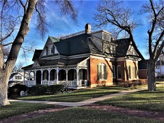 | Babbitt-Doerr House | 0.3 miles | 1995 |
| Patterson House | 0.6 miles | 2001 | |
| Ooten House | 0.8 miles | 2001 | |
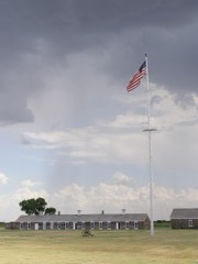 | Fort Larned National Historic Site | 7.0 miles | 1966 |
| National Archives record | The nomination case file for reference 100011706 in Record Group 79. |
| Pawnee County | All 7 listed properties in this county. |