 Block
From the record
7 National Register listings published here, 1 of them a National Historic Landmark.
Sources: the National Register database, National Park Service
38 topographic sheets cover 12 settlements here, and 7 properties are on the National Register of Historic Places.
7 National Register listings published here, 1 of them a National Historic Landmark.
Sources: the National Register database, National Park Service
Every property in this county listed on the National Register of Historic Places, with the year it was listed and the federal nomination document.
| Photograph | Property | Type | Listed | Reference |
|---|---|---|---|---|
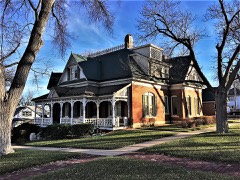 | Babbitt-Doerr House | building | 1995 | 95000477 |
| Coon Creek Crossing on the Santa Fe Trail (Wet Route) | site | 2013 | 13000493 | |
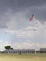 | Fort Larned National Historic Site | district | 1966 | 66000107 |
| JG Edwards Building | building | 2025 | 100011706 | |
| Ooten House | building | 2001 | 01000188 | |
| Patterson House | building | 2001 | 01000189 | |
| Township Line Bridge | structure | 1985 | 85001442 |
Every wildfire the federal occurrence database records inside this county: 32 of them, burning about 758 acres. 1 started naturally and 2 were recorded as arson. Each settlement page carries the fires within five miles of it.
| Reported cause | Fires |
|---|---|
| Debris and open burning | 12 |
| Missing data/not specified/undetermined | 10 |
| Equipment and vehicle use | 7 |
| Arson/incendiarism | 2 |
| Natural | 1 |
The five largest, by the area the report gives. None of them was recorded as arson.
| Date | Cause | Size | Reported by | Name on the report |
|---|---|---|---|---|
| 11 July 2020 | Debris and open burning | 320 acres | Kansas Forest Service | not named |
| 21 July 2017 | Debris and open burning | 140 acres | Pawnee County | 1714 |
| 31 August 2015 | Missing data/not specified/undetermined | 80 acres | Kansas Forest Service | 26 |
| 21 June 2018 | Equipment and vehicle use | 60 acres | Kansas Forest Service | 1809 |
| 6 August 2015 | Missing data/not specified/undetermined | 50 acres | Kansas Forest Service | 1507 |
| 5 May 2020 | Missing data/not specified/undetermined | 30 acres | Kansas Forest Service | not named |
| 15 September 2015 | Equipment and vehicle use | 20 acres | Kansas Forest Service | 1510 |
| 21 July 2017 | Debris and open burning | 10 acres | Pawnee County | 1713 |
Every settlement page carries the fires within five miles of it - see the settlement index below.
The NOAA Storm Events Database holds 766 reports for this county, causing no deaths, 5 injuries and about $6,386,100 in recorded property damage. Each settlement page carries the reports that name it.
| Kind of event | Reports |
|---|---|
| Hail | 457 |
| Thunderstorm Wind | 210 |
| Tornado | 45 |
| Heavy Rain | 31 |
| Flood | 16 |
| Flash Flood | 4 |
| Funnel Cloud | 2 |
| Lightning | 1 |
The most serious of them, by death, then injury, then recorded damage. The accounts are quoted exactly as the forecast office filed them.
| When | Event | Place named | Harm | What the report says |
|---|---|---|---|---|
| August 1984 | Thunderstorm Wind | not stated | 3 hurt | no account filed |
| August 1996 | Thunderstorm Wind | Larned | 1 hurt, $3,200,000 | no account filed |
| May 1950 | Tornado (F4) | not stated | 1 hurt, $250,000 | no account filed |
| May 1993 | Tornado (F1) | Larned | $500,000 | The tornado destroyed several farm buildings including sheds and grain bins. Seven center pivot irrigation systems were also destroyed. |
| May 1993 | Tornado (F0) | Larned | $500,000 | Tornado moved over open farmland and destroyed several irrigation systems. |
| May 1996 | Thunderstorm Wind | Larned | $250,000 | no account filed |
| August 1996 | Thunderstorm Wind | Zook | $250,000 | no account filed |
| June 1978 | Tornado (F1) | not stated | $250,000 | no account filed |
| April 1972 | Tornado (F3) | not stated | $250,000 | no account filed |
| May 2013 | Tornado (EF4) | Burdett Rucker Arpt | $140,000 | This tornado was well documented by storm chasers, spotters and a research team with portable doppler radar. The tornado did turn north towards the end of it's life cycle. Low end EF4 damage was done to a home along US156. The roof and walls were blown away of this well constructed house. Several large tanks were carried a long distance. There were 2 people inside but they escaped injury by taking shelter. Video shows that sub-vortices within the tornado may have actually had a little stronger wind. The Doppler on wheels that was observing the tornado had near surface measured wind speeds of 165 to 185 MPH. |
| May 2011 | Tornado (EF1) | Rozel | $110,000 | The thunderstorm that produced the tornado developed extremely quickly. The tornado did damage to trees and irrigation sprinklers and was rated a high end EF1. |
| August 2010 | Thunderstorm Wind | Larned | $100,000 | Damage at the Heritage Feeders was reported. There were many tall standing structures with some sort of damage, including the feed mill, concrete silo, sheds and concrete walls tipped over. |
| May 1999 | Hail | Larned | $100,000 | $100,000 in damage across the county. |
| August 2003 | Lightning | Larned | $80,000 | A house was hit by lightning and was completely destroyed |
| June 2009 | Tornado (EF1) | Zook | $50,000 | Several outbuildings were destroyed by this tornado. It was video taped by folks that were about 2 miles away and they could hardly believe what they were seeing. In fact, several times they doubted it was a tornado but it was clearly a tornado that traveled 5.1 miles north-northeast and heavily damaged two well built and new outbuildings. |
| June 1999 | Thunderstorm Wind | Larned | $40,000 | Power poles down and pivot sprinkler overturned. |
| April 2012 | Tornado (EF1) | Burdett | $35,000 | A tornado tracked across a farm and damaged an outbuilding and did roof damage to the home. |
| June 1999 | Thunderstorm Wind | Larned | $30,000 | Pivot sprinkler overturned and 18 inch diameter tree limb broken. |
| August 1996 | Thunderstorm Wind | Burdett Rozel Arpt | $25,000 | no account filed |
| May 1988 | Tornado (F2) | not stated | $25,000 | no account filed |
| October 1979 | Tornado (F2) | not stated | $25,000 | no account filed |
| August 1974 | Tornado (F2) | not stated | $25,000 | no account filed |
| June 1970 | Tornado (F2) | not stated | $25,000 | no account filed |
| May 1965 | Tornado | not stated | $25,000 | no account filed |
| June 1998 | Thunderstorm Wind | Larned | $20,000 | A 40 by 80 foot shed was destroyed. |
| July 2007 | Hail | Ash Valley | $15,000 | The hail did quite a bit of damage to vehicles at this location. |
| September 2007 | Thunderstorm Wind | Garfield | $10,000 | Power poles were blown down and all power was out in Garfield. |
| April 2006 | Thunderstorm Wind | Larned | $10,000 | Damage to Al Hanken Motors. Other areas of town had broken windows from an apparent Rear Flank Downdraft. |
| June 1998 | Thunderstorm Wind | Larned | $6,500 | Thirteen power poles blown down. |
| May 2013 | Thunderstorm Wind | Hamburg | $5,000 | Six power poles were snapped off along L Road between 150th and 160th. |
| June 1999 | Thunderstorm Wind | Larned | $5,000 | Large tree limbs down. |
| June 1994 | Thunderstorm Wind | Larned | $5,000 | Grain bin blown apart. |
| July 1994 | Thunderstorm Wind | Burdett | $5,000 | A thunderstorm producing winds to 52 knots (60 mph) caused roof damage. |
| August 1996 | Thunderstorm Wind | Burdett Rozel Arpt | $5,000 | no account filed |
| July 1977 | Tornado | not stated | $2,500 | no account filed |
| May 1965 | Tornado (F1) | not stated | $2,500 | no account filed |
| May 1965 | Tornado (F1) | not stated | $2,500 | no account filed |
| October 1956 | Tornado (F3) | not stated | $2,500 | no account filed |
| August 2010 | Thunderstorm Wind | Larned | $2,000 | Road signs along highway 156 were blown down into adjacent fields. |
| July 2007 | Flash Flood | Garfield | $1,000 | Highway 56 at Garfield was flooded with 6 to 8 inches of water. Some homes also had some flooding. |
| April 2006 | Thunderstorm Wind | Larned | $1,000 | Lots of tree damage but perhaps not enough to justify the estimated 100 mph wind. |
| June 1999 | Thunderstorm Wind | Larned | $500 | Three inch diameter limbs down. |
| October 2008 | Flood | Ray | $100 | Slow runoff from rain that occurred earlier in the week produced creek flooding that ran over secondary roads for several days. |
| April 2026 | Hail | Frizell | - | A public report of 1.5 inch hail. |
| April 2026 | Hail | Zook | - | A public report of 1 inch hail. |
| April 2025 | Hail | Larned | - | A public report for hail of 0.75 inches. |
| June 2025 | Thunderstorm Wind | Hamburg | - | The measured gust was reported by the Kansas State Mesonet. |
| June 2025 | Thunderstorm Wind | Hamburg | - | The measured gust was reported by the Kansas State Mesonet. |
| June 2025 | Thunderstorm Wind | Hamburg | - | The measured gust was reported by the Kansas State Mesonet. |
| June 2025 | Hail | Burdett Rozel Arpt | - | A report of one inch hail was received from a social media post. |
| June 2025 | Thunderstorm Wind | Hamburg | - | The report was received from the Kansas State Mesonet. |
| June 2025 | Thunderstorm Wind | Hamburg | - | The report was received from the Kansas State Mesonet. |
| June 2025 | Thunderstorm Wind | Hamburg | - | The measured gust was reported by the Kansas State Mesonet. |
| June 2025 | Thunderstorm Wind | Hamburg | - | The measured gust was reported by the Kansas State Mesonet. |
| May 2025 | Hail | Garfield | - | A mPING report. Time adjusted based on radar. |
| June 2025 | Heavy Rain | Rozel | - | A measured 1.88 inches of rain fell. |
| June 2025 | Thunderstorm Wind | Larned | - | A dead tree branch measuring 7 inches in diameter, was broken off. This wind damage report was received through social media. |
| July 2025 | Flash Flood | Zook | - | Public report via social media of flooding across roadway around this location. |
| August 2024 | Hail | Larned | - | Hail the size of quarters was reported by the public. |
| August 2024 | Hail | Larned | - | The public reported golf ball sized hail in Larned. |
The Survey's mineral resources record lists 2 workings inside this county. All of them still produce. Each settlement page carries the workings within five miles of it.
| Commodity | Workings |
|---|---|
| Sand and Gravel, Construction | 2 |
The least common of them first, because a county's hundredth gravel pit says nothing its first ten did not.
| Where | Site | Commodity | Status | Recorded |
|---|---|---|---|---|
| Eakin Sand and Gravel Co | Sand and Gravel, Construction | Producer | ||
| Larned Sand and Gravel | Sand and Gravel, Construction | Producer |
Named settlements recorded in the Geographic Names Information System, each with the topographic sheets covering it. Villages, hamlets and abandoned places alike. Each is shown with the nearest named watercourse or landform and the survey quadrangle it falls on.