 Block
From the record
One of 14 National Register listings published here for Osage County · listed in 2011 · category: Building.
Sources: the National Register database, National Park Service
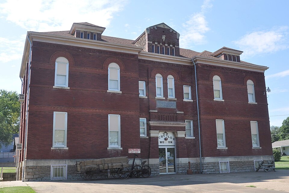
Listed on the National Register of Historic Places in 2011.
One of 14 National Register listings published here for Osage County · listed in 2011 · category: Building.
Sources: the National Register database, National Park Service
Regional context, not property-specific evidence. The federal wildfire occurrence database lists 64 fires within 5 miles of Schuyler Grade School between 2015 and 2020, burning about 1,238 acres in total. None started naturally. 1 was recorded as arson. Distance is straight-line from the map coordinates, so a fire counted here may appear on a neighbouring settlement's page as well.
| Reported cause | Fires |
|---|---|
| Debris and open burning | 41 |
| Missing data/not specified/undetermined | 10 |
| Equipment and vehicle use | 3 |
| Smoking | 2 |
| Misuse of fire by a minor | 2 |
| Recreation and ceremony | 2 |
| Power generation/transmission/distribution | 1 |
| Other causes | 1 |
| Fireworks | 1 |
| Arson/incendiarism | 1 |
The most recent of them, most recent first, with the day each was reported and the service that recorded it.
| Date | Cause | Size | Reported by | Name on the report |
|---|---|---|---|---|
| 4 August 2018 | Smoking | under an acre | Kansas Forest Service | 191 |
| 4 July 2018 | Fireworks | 1.0 acres | Kansas Forest Service | 163 |
| 22 July 2018 | Debris and open burning | 1.0 acres | Kansas Forest Service | 177 |
| 30 June 2015 | Debris and open burning | 5.0 acres | Kansas Forest Service | 163 |
| 28 June 2018 | Missing data/not specified/undetermined | under an acre | Kansas Forest Service | 156 |
| 5 May 2018 | Smoking | 1.0 acres | Kansas Forest Service | 117 |
| 18 May 2018 | Equipment and vehicle use | under an acre | Kansas Forest Service | 128 |
| 8 April 2015 | Debris and open burning | under an acre | Kansas Forest Service | 110 |
Regional context, not property-specific evidence. The National Weather Service names Burlingame, the town this property stands in, in 102 storm reports between 1993 and 2024: 65 hail, 24 thunderstorm wind, 6 flash flood, 4 flood. No death or injury is recorded in these reports. Each account below is quoted exactly as the forecast office filed it, from the NOAA Storm Events Database, and each date opens the federal record of that event.
| When | Event | Place named | Harm | What the report says |
|---|---|---|---|---|
| May 2007 | Flood | Burlingame | $750,000 | Nearly all streets heading both into and out of Burlingame are water covered and impassable. Several water rescues were performed. Roads were barricaded to prevent citizens from driving through the flooded roadways. The Burlingame post office was inundated with water, mud and worms. Two water rescues were made in Osage City. Water near Dragoon Creek flowing over highway 56 at least a mile wide. Public reports the highway 56 bridge was vibrating due to the force of the flowing water. Unofficial reports of 5 to 11 inches of rain in the county. Many federal, state and county highways flooded or closed. Record moderate or greater flooding on Salt Creek near Lyndon and near Quenemo on the Marais Des Cygnes river. |
| May 2007 | Flash Flood | Burlingame | $600,000 | Bridge was reported washed out on a country road near Burlingame. |
| March 2006 | Hail | Burlingame | $500,000 | A hailstorm struck the Burlingame area and caused significant property damage. The hail continued for over half an hour and damaged homes, windshields and even patrol cars of the sheriff's department. Hail up to the size of tennis balls covered the ground. |
| May 1995 | Hail | Burlingame | $500,000 | Large hail and high winds combined to produced a 1.5 mile wide west to east swath of damage through the northern part of the county. |
| May 2007 | Flash Flood | Burlingame | $400,000 | Eight inches of water across road. |
| May 2007 | Flash Flood | Burlingame | $100,000 | County dispatch reporting water over much of highway 56 from Scranton to Burlingame to Osage City. Water flowing over highway 56 was reported to be 1 to 2 feet deep in places. Parts of K-31 also had water flowing over the road. There were a couple of residences in Burlingame that had to be evacuated due to flood waters entering the homes. |
| May 1995 | Thunderstorm Wind | Burlingame | $25,000 | High winds tore down trees and large hail accumulated to a depth of two inches. |
| September 2010 | Thunderstorm Wind | Burlingame | $2,000 | Trained spotters across Osage County reported 6o to 70 mph wind gusts. An outbuilding had its roof ripped off by strong winds near Pomona Lake. |
| August 2024 | Thunderstorm Wind | Burlingame | - | Personal weather station from the outflow of weakening storms. |
| May 2024 | Tornado (EF0) | Burlingame | - | Survey revealed tree and tree limb damage in a field. The tornado may have developed just northwest of a structure where some wind damage was noted however this location appeared to have been east of the actual circulation so it may have been enhanced downdraft winds on the east flank of the tornado that did that minor damage. Radar also showed a CC minimum or a debris signature with this circulation. |
| June 2024 | Thunderstorm Wind | Burlingame | - | Social media report for multiple uprooted trees, and a large tree snapped at its base. |
| July 2024 | Flood | Burlingame | - | US highway 56 east of Kansas Street in Burlingame was flooded. |
| July 2024 | Flood | Burlingame | - | Highway 56 closed due to flooding from Dragoon Street. |
| April 2023 | Hail | Burlingame | - | Nickel sized hail reported. |
| July 2020 | Hail | Burlingame | - | Per social media post showing 2 inch hailstones. |
| May 2019 | Thunderstorm Wind | Burlingame | - | Estimated wind gusts of 60-70 mph. |
| June 2017 | Thunderstorm Wind | Burlingame | - | Wind speed was estimated. |
| June 2017 | Thunderstorm Wind | Burlingame | - | Wind speed was estimated. |
| April 2016 | Flood | Burlingame | - | Highway 56 is closed east of Burlingame and Burlingame Road is closed north of town due to flood waters over the road. Flood waters may have also closed Highway 56 south of Burlingame. |
| May 2015 | Flash Flood | Burlingame | - | Several county roads flooded though out Osage county. |
| September 2015 | Hail | Burlingame | - | Saw a broken wall cloud pass about 2 miles to the east. Did not see a funnel. |
| July 2014 | Thunderstorm Wind | Burlingame | - | Tree limbs up to 2 inches in diameter were down. Power out. |
| October 2013 | Thunderstorm Wind | Burlingame | - | Wind gust estimated. |
| May 2013 | Thunderstorm Wind | Burlingame | - | A 3 ft diameter tree fell on home. Mobile home blown 3 ft off its foundation. Several 1 ft diameter trees uprooted on the SE side of Burlingame. |
| April 2012 | Thunderstorm Wind | Burlingame | - | Numerous tree limbs were down at the intersection of West 125th Stree and Hoch Roads. The largest was just over 3 inches in diameter. |
| February 2012 | Tornado (EF2) | Burlingame | - | This is the continued path of the tornado that crossed from Wabaunsee County into Osage County and weakened. The tornado path narrowed and damaged hedge row trees and two structures before dissipating. |
| August 2011 | Thunderstorm Wind | Burlingame | - | Three to four inch diameter tree limbs blown down. |
| April 2010 | Thunderstorm Wind | Burlingame | - | A storm chaser near Burlingame reported an estimated 60 mph wind gust. |
| May 2009 | Flash Flood | Burlingame | - | One foot of water reported to be flowing over Highway 56 between Scranton and Burlingame. Water also flowing over the roadway on Highway 75 east of 173rd Street. Numerous streets were reported to be flooded in Scranton, and several were barricaded to prevent drivers from passing through affected roadways. |
| April 2008 | Thunderstorm Wind | Burlingame | - | Small tree limbs blown down. Full trash containers blown down the street. |
| April 2008 | Thunderstorm Wind | Burlingame | - | Two to three inch tree limbs blown down. |
| October 2007 | Hail | Burlingame | - | Hail up to the size of baseballs fell in town. |
| November 2005 | Thunderstorm Wind | Burlingame | - | Large tree limbs downed. |
| April 2003 | Heavy Rain | Burlingame | - | Heavy rains of 2 to 3 inches fell in a short time in the Burlingame and Scranton areas causing ditches to run full with water spilling onto roads in the area. |
| April 1993 | Hail | Burlingame | - | Most hailstones were in the 0.25- to 0.50-inch range with an occasional larger piece. |
| July 2020 | Hail | Burlingame | - | no account filed |
| May 2017 | Hail | Burlingame | - | no account filed |
| June 2015 | Hail | Burlingame | - | no account filed |
| June 2015 | Hail | Burlingame | - | no account filed |
| June 2015 | Hail | Burlingame | - | no account filed |
| August 2015 | Hail | Burlingame | - | no account filed |
| March 2015 | Hail | Burlingame | - | no account filed |
| May 2014 | Hail | Burlingame | - | no account filed |
| May 2014 | Hail | Burlingame | - | no account filed |
| May 2014 | Hail | Burlingame | - | no account filed |
| October 2013 | Hail | Burlingame | - | no account filed |
| April 2012 | Hail | Burlingame | - | no account filed |
| April 2012 | Hail | Burlingame | - | no account filed |
| February 2012 | Hail | Burlingame | - | no account filed |
| March 2012 | Hail | Burlingame | - | no account filed |
| March 2012 | Hail | Burlingame | - | no account filed |
| March 2012 | Hail | Burlingame | - | no account filed |
| March 2012 | Hail | Burlingame | - | no account filed |
| March 2012 | Hail | Burlingame | - | no account filed |
| March 2012 | Hail | Burlingame | - | no account filed |
| April 2011 | Hail | Burlingame | - | no account filed |
| April 2011 | Hail | Burlingame | - | no account filed |
| August 2011 | Hail | Burlingame | - | no account filed |
| April 2011 | Hail | Burlingame | - | no account filed |
| April 2011 | Hail | Burlingame | - | no account filed |
No historic map-sheet match is published for this property yet. That does not mean no map exists. This record needs a coordinate-quality review before it can be joined to a sheet boundary. Browse the county's mapped places while that work is pending.
Other National Register properties close enough to walk or drive between, ordered by distance from this one. Both positions come from the same geocoding pass that matched these properties to their map sheets.
| Photograph | Property | Distance | Listed |
|---|---|---|---|
| Samuel Hunt Grave | 4.8 miles | 1995 |
| National Archives record | The nomination case file for reference 11000193 in Record Group 79. |
| Osage County | All 14 listed properties in this county. |