 Block
From the record
14 National Register listings published here.
Sources: the National Register database, National Park Service
41 topographic sheets cover 19 settlements here, and 14 properties are on the National Register of Historic Places.
14 National Register listings published here.
Sources: the National Register database, National Park Service
Every property in this county listed on the National Register of Historic Places, with the year it was listed and the federal nomination document.
| Photograph | Property | Type | Listed | Reference |
|---|---|---|---|---|
 | Arvonia School | building | 2012 | 12000387 |
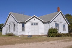 | Arvonia Township Hall | building | 2017 | 100000516 |
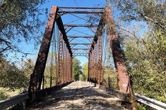 | Atchison, Topeka, and Santa Fe Pratt Truss Bridge | structure | 2003 | 03000364 |
| Banner Hereford Farm | district | 1998 | 98000659 | |
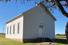 | Calvinistic Methodist Church | building | 2012 | 12000388 |
| Samuel Hunt Grave | site | 1995 | 95000586 | |
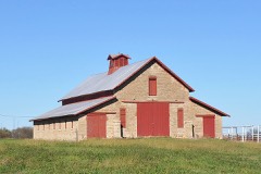 | Karnes Stone Barn | building | 2004 | 03001468 |
| Luther Severy & Son Stock Farm | district | 2023 | 100008526 | |
 | Lyndon Carnegie Library | building | 1987 | 87000965 |
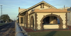 | Osage City Santa Fe Depot | building | 1989 | 89000386 |
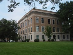 | Osage County Courthouse | building | 2007 | 07000320 |
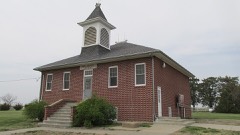 | Rapp School District No. 50 | building | 1995 | 95000944 |
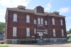 | Schuyler Grade School | building | 2011 | 11000193 |
| Star Block | building | 2020 | 100005954 |
Every wildfire the federal occurrence database records inside this county: 359 of them, burning about 7,196 acres. 1 started naturally and 7 were recorded as arson. Each settlement page carries the fires within five miles of it.
| Reported cause | Fires |
|---|---|
| Debris and open burning | 220 |
| Missing data/not specified/undetermined | 97 |
| Equipment and vehicle use | 11 |
| Smoking | 11 |
| Arson/incendiarism | 7 |
| Recreation and ceremony | 4 |
| Misuse of fire by a minor | 3 |
| Other causes | 2 |
| Power generation/transmission/distribution | 2 |
| Natural | 1 |
| Fireworks | 1 |
The five largest, by the area the report gives. None of them was recorded as arson.
| Date | Cause | Size | Reported by | Name on the report |
|---|---|---|---|---|
| 30 March 2014 | Missing data/not specified/undetermined | 1,500 acres | Osage County | DRAGOON CREEK |
| 30 March 2014 | Missing data/not specified/undetermined | 520 acres | Osage County | 80 FIRE |
| 30 March 2014 | Missing data/not specified/undetermined | 320 acres | Osage County | 81 FIRE |
| 1 March 2016 | Missing data/not specified/undetermined | 250 acres | Kansas Forest Service | 42 |
| 11 November 2015 | Other causes | 230 acres | Kansas Forest Service | 279 |
| 28 February 2016 | Missing data/not specified/undetermined | 200 acres | Lyon County | READING 285 |
| 15 January 2015 | Missing data/not specified/undetermined | 200 acres | Kansas Forest Service | 6 |
| 28 January 2015 | Debris and open burning | 180 acres | Kansas Forest Service | 19 |
Every settlement page carries the fires within five miles of it - see the settlement index below.
The NOAA Storm Events Database holds 864 reports for this county, causing 22 deaths, 26 injuries and about $34,074,500 in recorded property damage. Each settlement page carries the reports that name it.
| Kind of event | Reports |
|---|---|
| Hail | 459 |
| Thunderstorm Wind | 277 |
| Tornado | 51 |
| Flash Flood | 44 |
| Funnel Cloud | 13 |
| Flood | 11 |
| Heavy Rain | 7 |
| Lightning | 2 |
The most serious of them, by death, then injury, then recorded damage. The accounts are quoted exactly as the forecast office filed them.
| When | Event | Place named | Harm | What the report says |
|---|---|---|---|---|
| June 1978 | Tornado (F1) | not stated | 16 killed, 3 hurt, $250,000 | no account filed |
| October 1984 | Thunderstorm Wind | not stated | 4 killed, 10 hurt | no account filed |
| May 2008 | Lightning | Pomona Res | 1 killed, 3 hurt | Four men were camping at Pomona Lake State Park. A thunderstorm rolled through, and lightning struck the tent in which the men were sleeping. The three men in the tent were injured, but the fourth man standing outside the tent near a tree was killed. It was reported that he was killed as he headed toward more sturdy shelter. |
| October 1984 | Tornado (F1) | not stated | 1 killed, $250,000 | no account filed |
| June 1999 | Thunderstorm Wind | Melvern | 5 hurt, $2,000 | Strong winds overturned trailers at Melvern Lake resulting in minor damage and minor injuries to 5 people. |
| May 2002 | Thunderstorm Wind | Melvern | 2 hurt, $6,000 | Strong winds blew several tents over as well as several pull behind vehicles. Two children received minor injuries. |
| July 1986 | Thunderstorm Wind | not stated | 2 hurt | no account filed |
| May 1978 | Tornado (F2) | not stated | 1 hurt, $250,000 | no account filed |
| June 1974 | Tornado (F4) | not stated | $25,000,000 | no account filed |
| May 2003 | Tornado (F3) | Osage City | $1,500,000 | A second tornado touched down in Osage county about 13 miles southwest of Lyndon and moved northeast for 25 miles before dissipating 6 miles south of Overbrook. The tornado was a half mile wide in places and did considerable damage to farm buildings, machinery, and fences along its path. |
| May 2007 | Flood | Burlingame | $750,000 | Nearly all streets heading both into and out of Burlingame are water covered and impassable. Several water rescues were performed. Roads were barricaded to prevent citizens from driving through the flooded roadways. The Burlingame post office was inundated with water, mud and worms. Two water rescues were made in Osage City. Water near Dragoon Creek flowing over highway 56 at least a mile wide. Public reports the highway 56 bridge was vibrating due to the force of the flowing water. Unofficial reports of 5 to 11 inches of rain in the county. Many federal, state and county highways flooded or closed. Record moderate or greater flooding on Salt Creek near Lyndon and near Quenemo on the Marais Des Cygnes river. |
| May 2007 | Flash Flood | Burlingame | $600,000 | Bridge was reported washed out on a country road near Burlingame. |
| June 2007 | Flood | Quenemo | $500,000 | Marais des Cygnes river reaches moderate flooding stage with flooding continuing into early July. The river reaches record levels at Quenemo. |
| March 2006 | Hail | Burlingame | $500,000 | A hailstorm struck the Burlingame area and caused significant property damage. The hail continued for over half an hour and damaged homes, windshields and even patrol cars of the sheriff's department. Hail up to the size of tennis balls covered the ground. |
| May 1995 | Hail | Burlingame | $500,000 | Large hail and high winds combined to produced a 1.5 mile wide west to east swath of damage through the northern part of the county. |
| May 2007 | Flash Flood | Burlingame | $400,000 | Eight inches of water across road. |
| November 1998 | Flash Flood | Lyndon | $400,000 | no account filed |
| June 1990 | Tornado (F1) | not stated | $250,000 | no account filed |
| June 1990 | Tornado (F0) | not stated | $250,000 | no account filed |
| May 1962 | Tornado (F2) | not stated | $250,000 | no account filed |
| May 1955 | Tornado (F2) | not stated | $250,000 | no account filed |
| May 2003 | Tornado (F1) | Barclay | $246,000 | A tornado touched down 8 miles southsouthwest of Barclay and moved northeast before dissipating 6 miles south of Osage City. The tornado damaged farm buildings and machinery along its path. |
| June 1998 | Thunderstorm Wind | Melvern | $200,000 | no account filed |
| July 2007 | Flood | Quenemo | $150,000 | Flooding continues into early July. A number of roads continue under water especially around Quenemo. A state report indicated that the flood waters destroyed two houses, caused major damage to 5 and minor damage to 10. |
| May 1995 | Hail | Carbondale | $125,000 | Large hail and high winds combined to produced a 1.5 mile wide west to east swath of damage through the northern of the county, mainly along highway 56 from Overbrook and then west near highway 31. |
| May 2008 | Tornado (EF0) | Lyndon | $100,000 | The roof of a residence was lifted and dropped back onto the frame of the house. A large antenna that was cemented into the ground was blown over, which tore the cement block from the ground. Windows were blown out on the southern and northern sides of the house. Debris from the residence was carried approximately 100 yards away. A large, three car garage was partially destroyed just before the tornado lifted. A piece of the roof of the garage fell onto and damaged the motor home inside. Debris from the garage was carried nearly 100 yards and across a street to the Vassar Cemetary. There, one headstone was toppled. |
| June 2007 | Flash Flood | Lyndon | $100,000 | Hwy 68 from Hwy 268 to Hwy 75 was flooded. At least 6 inches of fast flowing water reprted over Stubbs road. Fast flowing water also over several highways in the Quenemo area. |
| June 2007 | Flash Flood | Quenemo | $100,000 | The Hwy 75 bridge was covered by the flooded Salt Creek just south of Lyndon. Numerous roads in the Lyndon and Quenemo areas flooded. KSNT TV reports the fire department has ordered evacuations of residences in low lying areas in Quenemo. 110 mile creek is out of its banks and water if flooding Fairlawn road. |
| May 2007 | Flash Flood | Burlingame | $100,000 | County dispatch reporting water over much of highway 56 from Scranton to Burlingame to Osage City. Water flowing over highway 56 was reported to be 1 to 2 feet deep in places. Parts of K-31 also had water flowing over the road. There were a couple of residences in Burlingame that had to be evacuated due to flood waters entering the homes. |
| June 2005 | Flash Flood | Osage City | $100,000 | At least 6 inches of fast flowing water across roads in the Osage City area. |
| October 2005 | Flash Flood | Scranton | $100,000 | Rainfall of around 4 inches brought at least 6 inches of fast flowing water across rural roads just north of Scranton. Roads were barricaded. |
| September 2005 | Heavy Rain | Lyndon | $100,000 | Urban and street flooding in and around Lyndon. |
| July 2007 | Flash Flood | Overbrook | $75,000 | Highway 56 flooded west of Overbrook. Water appeared 5 to 6 feet deep along the side of the road. Spotter reported 3.5 inches of rain within about an hour and a half. Water reported flowing around and into the basement of a home. |
| November 1998 | Tornado (F0) | Carbondale | $75,000 | A small rain-wrapped tornado damaged or destroyed mainly outbuildings, barns, trees and a few roofs as it moved northeast from southwest of Carbondale, across Main and Second streets before dissipating a little west of US Highway 75. Most of the damage occurred southwest of town and in about a 2 block section around Main and Second streets near the downtown area. |
| June 2005 | Flash Flood | Scranton | $60,000 | 165th street closed to wanamaker along west city limits due to fast flowing water over highway. |
| July 1996 | Thunderstorm Wind | Olivet | $60,000 | no account filed |
| May 2007 | Flash Flood | Overbrook | $50,000 | Water reported flowing over highway 56 in town. |
| June 2005 | Heavy Rain | Osage City | $50,000 | Two to seven inches of rain caused lowland and small stream flooding. |
| August 2005 | Heavy Rain | Countywide | $50,000 | Widespread lowland and small stream flooding from heavy rain. One indirect injury in accident due to hydroplaning on Interstate 35 south of Melvern. |
| July 1994 | Thunderstorm Wind | Osage City | $50,000 | High winds knocked down trees, power lines and damaged some buildings. Power in some areas was out for 24 hours. |
| May 1995 | Thunderstorm Wind | Burlingame | $25,000 | High winds tore down trees and large hail accumulated to a depth of two inches. |
| May 1995 | Thunderstorm Wind | Wilmington | $25,000 | High winds flipped a truck on its side that was parked on the Kansas turnpike. |
| October 1998 | Flash Flood | Lyndon | $25,000 | no account filed |
| June 1989 | Tornado (F0) | not stated | $25,000 | no account filed |
| May 1982 | Tornado (F0) | not stated | $25,000 | no account filed |
| June 1965 | Tornado (F1) | not stated | $25,000 | no account filed |
| July 2004 | Thunderstorm Wind | Melvern | $20,000 | Strong winds hit near Melvern. Considerable damage was reported. A roof was blown off a shed. Trees were reported snapped or twisted. A camper shell was carried over one half mile. Power poles were snapped leaving power outages up to 10 hours. |
| April 2003 | Tornado (F0) | Quenemo | $15,000 | A weak tornado touched down briefly and knocked down trees and 2 power poles and damaged an out building. |
| June 1999 | Thunderstorm Wind | Pomona Res | $12,000 | Strong winds overturned trailers and damaged 2 boat docks and nearly 40 boats. |
| April 1995 | Thunderstorm Wind | Overbrook | $10,000 | High winds and very large hail caused damage to buildings east of Overbrook and then eastward into Douglas county. The United States DA reported hail and wind damage to about 80,000 acres in Osage county. Douglas County Globe,16,0743CST,,,0,0,10K,?,Thunderstorm Winds (G70) High winds with large hail produced damage to buildings and vehicles. |
| June 2004 | Thunderstorm Wind | Lyndon | $5,000 | Strong winds blew trees down on power lines knocking out power for a time. |
| June 2004 | Thunderstorm Wind | Overbrook | $5,000 | Strong winds blew some power lines down. |
| June 1995 | Hail | Melvern Lake | $5,000 | Large hail accompanied very heavy rainfall in southern Osage County. |
| April 1995 | Thunderstorm Wind | Lyndon | $5,000 | High winds damaged some outbuildings near a farm. |
| March 1993 | Hail | Overbrook | $5,000 | Hail from 0.75-inch to golfball-size did minor damage to cars across parts of Osage County |
| April 1995 | Hail | Overbrook | $5,000 | no account filed |
| June 2004 | Thunderstorm Wind | Lyndon | $4,000 | Strong winds blew shutters off of a house. |
| April 1995 | Hail | Overbrook | $4,000 | no account filed |
| June 1999 | Thunderstorm Wind | Melvern | $3,000 | Strong winds blew down tree limbs doing minor damage to property and buildings. |
| June 1998 | Thunderstorm Wind | Lyndon | $3,000 | no account filed |
Named settlements recorded in the Geographic Names Information System, each with the topographic sheets covering it. Villages, hamlets and abandoned places alike. Each is shown with the nearest named watercourse or landform and the survey quadrangle it falls on.
Burlingame township · 66413 · On Hoover Branch · Burlingame quadrangle
16 sheets, 1889 to 1983
Osage City city · 66523 · On Kibbie Creek · Osage City quadrangle
14 sheets, 1889 to 1983