 Block
From the record
One of 26 National Register listings published here for McPherson County · listed in 2011 · category: Building · built in 1893, Italianate architecture.
Sources: the National Register database, National Park Service
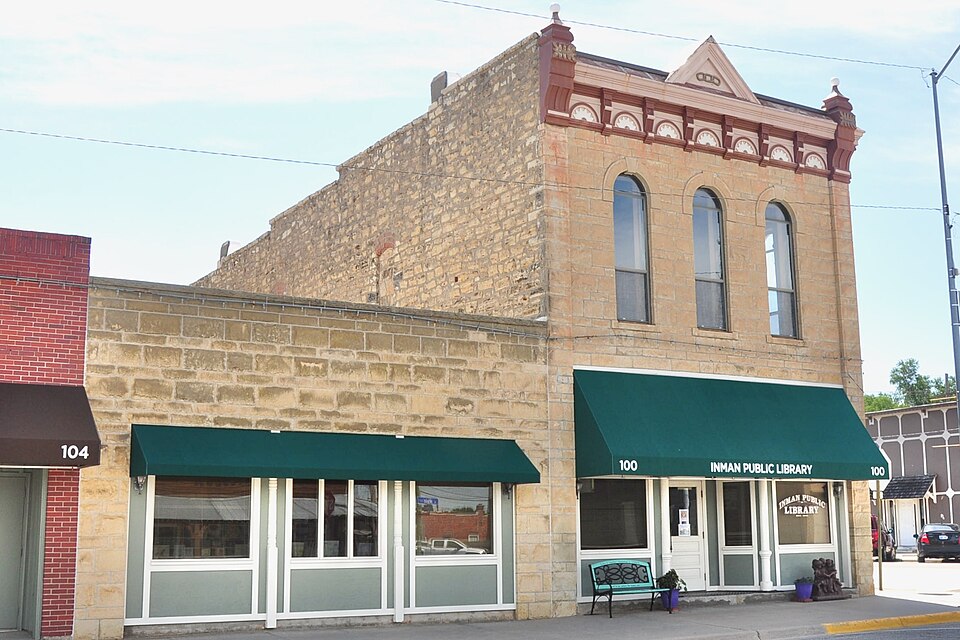
Built in 1893 (Italianate architecture). Listed on the National Register of Historic Places in 2011.
One of 26 National Register listings published here for McPherson County · listed in 2011 · category: Building · built in 1893, Italianate architecture.
Sources: the National Register database, National Park Service
Regional context, not property-specific evidence. The federal wildfire occurrence database lists 20 fires within 5 miles of Inman I.O.O.F. Hall between 2005 and 2018, burning about 265 acres in total. None started naturally. None was recorded as arson. Distance is straight-line from the map coordinates, so a fire counted here may appear on a neighbouring settlement's page as well.
| Reported cause | Fires |
|---|---|
| Debris and open burning | 12 |
| Missing data/not specified/undetermined | 7 |
| Recreation and ceremony | 1 |
The most recent of them, most recent first, with the day each was reported and the service that recorded it.
| Date | Cause | Size | Reported by | Name on the report |
|---|---|---|---|---|
| 12 August 2017 | Debris and open burning | 1.0 acres | McPherson County | 116 |
| 8 July 2017 | Debris and open burning | 2.0 acres | McPherson County | 94 |
| 7 July 2017 | Debris and open burning | 1.0 acres | McPherson County | 93 |
| 5 July 2015 | Missing data/not specified/undetermined | under an acre | Kansas Forest Service | 91 |
| 2 July 2018 | Recreation and ceremony | under an acre | Kansas Forest Service | 110 |
| 23 June 2018 | Debris and open burning | 3.0 acres | Kansas Forest Service | 103 |
| 17 June 2017 | Debris and open burning | under an acre | McPherson County | 76 |
| 10 June 2017 | Missing data/not specified/undetermined | 60 acres | McPherson County | 72 |
Regional context, not property-specific evidence. The National Weather Service names Inman, the town this property stands in, in 68 storm reports between 1996 and 2025: 35 hail, 23 thunderstorm wind, 4 flood, 3 heavy rain. No death or injury is recorded in these reports. Each account below is quoted exactly as the forecast office filed it, from the NOAA Storm Events Database, and each date opens the federal record of that event.
| When | Event | Place named | Harm | What the report says |
|---|---|---|---|---|
| August 2011 | Thunderstorm Wind | Inman | $75,000 | A powerful supercell thunderstorm produced extreme straight-line wind damage in the Inman area. Winds estimated up to 90 mph tore a portion of a roof from a residence, and also blew out several windows at that same residence. Thereafter, heavy rainfall rushed through the broken windows and section of missing roof, damaging some of the interior. At a neighbors house, a shed in the backyard was destroyed. Additionally, a few windows in the house were broken and the garage wall was moved about one foot. Damage amounts are rough estimates. The Hutchinson News was the sole contributor to this report. |
| July 2009 | Thunderstorm Wind | Inman | $30,000 | A tin roof was blown off a roof of a business. The damaging winds also sheered a portion of the roof off. A 40 foot high bell tower was also destroyed. |
| June 2013 | Thunderstorm Wind | Inman | $5,000 | A hay shed was destroyed. The time was estimated by radar. |
| June 2009 | Flash Flood | Inman | $5,000 | Several reports of water covered roads in and around McPherson. The flood waters flooded the basketball courts at Challenger Park in McPherson. Rainfall amounts were measured at 3.25 inches. |
| July 2009 | Thunderstorm Wind | Inman | $5,000 | A fifth wheel camper was blown over. |
| August 2013 | Flood | Inman | $100 | Numerous roads east of Inman had water over the road. |
| May 2009 | Flood | Inman | $100 | Water was over 14th avenue in multiple places. County roads also flooded around Inman. |
| June 2025 | Thunderstorm Wind | Inman | - | Wind gusts were estimated between 70 and 80 mph. Very heavy rainfall was also occurring. |
| May 2024 | Hail | Inman | - | Nickel to quarter sized hail and wind gusts of 40 to 50 mph were reported in Inman. |
| June 2024 | Thunderstorm Wind | Inman | - | Broadcast media (KAKE TV) meteorologist reported winds stronger than 60 mph. |
| September 2024 | Thunderstorm Wind | Inman | - | A trained spotter estimated wind gusts around 70 mph. Nearby, 3-inch diameter tree limbs were reported to be broken as well as some damage to power poles. |
| August 2023 | Heavy Rain | Inman | - | Rainfall in the past 24hours of 2.10 inches. |
| August 2023 | Thunderstorm Wind | Inman | - | Social media report of 4 to 5 inch limbs down. |
| November 2022 | Heavy Rain | Inman | - | A Cocorahs observer reported 1.86 inches of rainfall. |
| May 2021 | Flood | Inman | - | Ditches were running full and a few roads had some water over them. |
| August 2021 | Thunderstorm Wind | Inman | - | Trees were uprooted or snapped. A roof was blown off. The report came via MPING. |
| August 2019 | Thunderstorm Wind | Inman | - | The spotter stated that the winds were approaching 60 mph and that hail was also occurring. The size of the hail was unknown since the spotter was driving at the time. |
| May 2018 | Thunderstorm Wind | Inman | - | No damage was reported. |
| April 2015 | Hail | Inman | - | The trained spotter reported quarter sized hail covering the ground. |
| May 2014 | Tornado (EF0) | Inman | - | Very brief touchdown with no damage. |
| May 2014 | Tornado (EF0) | Inman | - | Power flashes were noted from this brief touchdown. |
| June 2014 | Thunderstorm Wind | Inman | - | The public reported the wind gusts. |
| June 2013 | Hail | Inman | - | The report was delayed, therefore the time of occurrence was based on radar. |
| July 2013 | Hail | Inman | - | No damage was reported. |
| August 2013 | Flood | Inman | - | Widespread nuisance flooding was noted across the whole county. Many county roads were impassable due to mud. |
| May 2012 | Hail | Inman | - | Measured 1.75 inches in diameter and 1 inch thick. Time of occurrence estimated from Doppler. |
| May 2012 | Heavy Rain | Inman | - | Measured 4.35 inches total rainfall. estimated time per Doppler. |
| May 2012 | Hail | Inman | - | Covered ground. |
| June 2011 | Thunderstorm Wind | Inman | - | Estimated gust reported by a law enforcement officer. |
| August 2010 | Thunderstorm Wind | Inman | - | A trained spotter reported the gust. |
| June 2009 | Thunderstorm Wind | Inman | - | Wind estimated by a trained spotter. |
| May 2005 | Thunderstorm Wind | Inman | - | Downed large limbs. |
| June 2005 | Hail | Inman | - | CO-OP observer. |
| July 2005 | Hail | Inman | - | Damage? |
| May 2002 | Thunderstorm Wind | Inman | - | Limbs downed. |
| April 2001 | Hail | Inman | - | Occurred on the Reno/McPherson county line. |
| June 2000 | Thunderstorm Wind | Inman | - | Four to five inch diameter tree limbs downed. |
| September 2025 | Hail | Inman | - | no account filed |
| July 2024 | Thunderstorm Wind | Inman | - | no account filed |
| June 2023 | Hail | Inman | - | no account filed |
| May 2021 | Hail | Inman | - | no account filed |
| September 2017 | Hail | Inman | - | no account filed |
| June 2016 | Hail | Inman | - | no account filed |
| April 2015 | Hail | Inman | - | no account filed |
| July 2015 | Hail | Inman | - | no account filed |
| July 2015 | Hail | Inman | - | no account filed |
| April 2013 | Hail | Inman | - | no account filed |
| April 2013 | Hail | Inman | - | no account filed |
| April 2013 | Hail | Inman | - | no account filed |
| June 2011 | Hail | Inman | - | no account filed |
| May 2010 | Hail | Inman | - | no account filed |
| March 2007 | Hail | Inman | - | no account filed |
| July 2005 | Hail | Inman | - | no account filed |
| August 2005 | Thunderstorm Wind | Inman | - | no account filed |
| August 2005 | Thunderstorm Wind | Inman | - | no account filed |
| June 2004 | Hail | Inman | - | no account filed |
| July 2004 | Hail | Inman | - | no account filed |
| September 2003 | Thunderstorm Wind | Inman | - | no account filed |
| June 2002 | Thunderstorm Wind | Inman | - | no account filed |
| June 2002 | Hail | Inman | - | no account filed |
No historic map-sheet match is published for this property yet. That does not mean no map exists. This record needs a coordinate-quality review before it can be joined to a sheet boundary. Browse the county's mapped places while that work is pending.
| National Archives record | The nomination case file for reference 11000195 in Record Group 79. |
| McPherson County | All 26 listed properties in this county. |