 Block
From the record
One of 24 National Register listings published here for Harvey County · listed in 2012 · category: District.
Sources: the National Register database, National Park Service
Listed on the National Register of Historic Places in 2012.
One of 24 National Register listings published here for Harvey County · listed in 2012 · category: District.
Sources: the National Register database, National Park Service
Regional context, not property-specific evidence. The federal wildfire occurrence database lists 36 fires within 5 miles of Sedgwick Downtown Historic District between 2015 and 2018, burning about 255 acres in total. None started naturally. 2 were recorded as arson. Distance is straight-line from the map coordinates, so a fire counted here may appear on a neighbouring settlement's page as well.
| Reported cause | Fires |
|---|---|
| Missing data/not specified/undetermined | 21 |
| Debris and open burning | 11 |
| Arson/incendiarism | 2 |
| Other causes | 1 |
| Equipment and vehicle use | 1 |
The most recent of them, most recent first, with the day each was reported and the service that recorded it.
| Date | Cause | Size | Reported by | Name on the report |
|---|---|---|---|---|
| 7 September 2015 | Missing data/not specified/undetermined | 1.0 acres | Kansas Forest Service | 6811 |
| 20 September 2017 | Missing data/not specified/undetermined | under an acre | Sedgwick County | 6771 |
| 2 September 2017 | Missing data/not specified/undetermined | 1.0 acres | Harvey County | 18213 |
| 10 August 2017 | Missing data/not specified/undetermined | under an acre | Harvey County | 111 |
| 4 July 2015 | Missing data/not specified/undetermined | 1.0 acres | Kansas Forest Service | 5045 |
| 3 July 2015 | Missing data/not specified/undetermined | under an acre | Kansas Forest Service | 123 |
| 12 July 2017 | Missing data/not specified/undetermined | 2.0 acres | Harvey County | 100 |
| 30 June 2015 | Other causes | 100 acres | Kansas Forest Service | 4961 |
Regional context, not property-specific evidence. The National Weather Service names Sedgwick, the town this property stands in, in 37 storm reports between 1995 and 2025: 20 hail, 11 thunderstorm wind, 4 flood, 1 tornado. No death or injury is recorded in these reports. Each account below is quoted exactly as the forecast office filed it, from the NOAA Storm Events Database, and each date opens the federal record of that event.
| When | Event | Place named | Harm | What the report says |
|---|---|---|---|---|
| June 2001 | Tornado (F0) | Sedgwick | $50,000 | Two large sheds destroyed and siding stripped from one home. |
| May 2009 | Thunderstorm Wind | Sedgwick | $32,500 | Numerous trees were knocked down across town from winds estimated to be 70 to 80 mph. |
| June 1998 | Thunderstorm Wind | Sedgwick | $1,000 | Tree damage and construction signs blown down on U.S. Highway 50. |
| October 2018 | Flood | Sedgwick | $200 | A car was reported stuck in deep water near 87th Street in the town Sedgwick near the Little Arkansas River. |
| October 2018 | Flood | Sedgwick | $100 | Some flooding was reported north of the town of Sedgwick, Kansas. |
| October 2018 | Flood | Sedgwick | $100 | Flooding was reported along 4th Street in the town of Sedgwick. |
| May 2024 | Thunderstorm Wind | Sedgwick | - | Trees and powerlines were down in the city. |
| July 2024 | Thunderstorm Wind | Sedgwick | - | Trained spotter reported an estimated wind gust of 60 mph. |
| April 2024 | Thunderstorm Wind | Sedgwick | - | An irrigation pivot below onto the roadway at 60th and Emma Creek. |
| August 2024 | Thunderstorm Wind | Sedgwick | - | Several large trees were uprooted throughout the town of Sedgwick. |
| June 2023 | Hail | Sedgwick | - | There was pea sized hail covering the ground. Some hail stones were quarter sized. |
| August 2023 | Thunderstorm Wind | Sedgwick | - | Measured wind gust of 61kts. |
| March 2022 | Hail | Sedgwick | - | Dime to nickel sized hail was estimated. |
| June 2022 | Thunderstorm Wind | Sedgwick | - | Damage was reported to the roofs of a barn and a house. |
| May 2020 | Hail | Sedgwick | - | The report was relayed via Twitter. |
| June 2016 | Hail | Sedgwick | - | Report came in via Facebook. |
| June 2015 | Flash Flood | Sedgwick | - | Several streets in Sedgwick have become covered by water and barricades have been put in place. Other county roads in the area are also covered with water. |
| April 2015 | Hail | Sedgwick | - | The public report was relayed via KWCH-TV. |
| May 2014 | Thunderstorm Wind | Sedgwick | - | Reported at the intersection of Interstate 135 and Kansas highway 196. |
| July 2013 | Flood | Sedgwick | - | Police advise that Ridge Road north of 109th Street north to the county line flooded and impassable. |
| May 2012 | Thunderstorm Wind | Sedgwick | - | Downed numerous tree limbs. |
| October 1998 | Thunderstorm Wind | Sedgwick | - | Tree limbs blown down. |
| September 2025 | Hail | Sedgwick | - | no account filed |
| May 2019 | Hail | Sedgwick | - | no account filed |
| May 2016 | Hail | Sedgwick | - | no account filed |
| June 2016 | Hail | Sedgwick | - | no account filed |
| May 2016 | Hail | Sedgwick | - | no account filed |
| March 2012 | Hail | Sedgwick | - | no account filed |
| May 2009 | Hail | Sedgwick | - | no account filed |
| March 2009 | Hail | Sedgwick | - | no account filed |
| May 2007 | Hail | Sedgwick | - | no account filed |
| June 2005 | Hail | Sedgwick | - | no account filed |
| June 2005 | Hail | Sedgwick | - | no account filed |
| June 2005 | Hail | Sedgwick | - | no account filed |
| March 2002 | Hail | Sedgwick | - | no account filed |
| October 1998 | Hail | Sedgwick | - | no account filed |
| July 1995 | Hail | Sedgwick | - | no account filed |
No historic map-sheet match is published for this property yet. That does not mean no map exists. This record needs a coordinate-quality review before it can be joined to a sheet boundary. Browse the county's mapped places while that work is pending.
Other National Register properties close enough to walk or drive between, ordered by distance from this one. Both positions come from the same geocoding pass that matched these properties to their map sheets.
| Photograph | Property | Distance | Listed |
|---|---|---|---|
| US Post Office-Halstead | 7.3 miles | 1989 | |
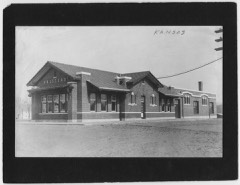 | Halstead Santa Fe Depot | 7.5 miles | 2001 |
| Bernhard Warkentin Homestead | 7.5 miles | 1974 | |
| Bergtholdt House | 7.7 miles | 1996 |
| National Archives record | The nomination case file for reference 11001079 in Record Group 79. |
| Harvey County | All 24 listed properties in this county. |