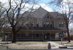
Block
From the record
24 National Register listings published here, 1 of them a National Historic Landmark.
Sources: the National Register database, National Park Service
59 topographic sheets cover 17 settlements here, and 24 properties are on the National Register of Historic Places.
24 National Register listings published here, 1 of them a National Historic Landmark.
Sources: the National Register database, National Park Service
Every property in this county listed on the National Register of Historic Places, with the year it was listed and the federal nomination document.
Every wildfire the federal occurrence database records inside this county: 228 of them, burning about 16,864 acres. 2 started naturally and 24 were recorded as arson. Each settlement page carries the fires within five miles of it.
| Reported cause | Fires |
|---|---|
| Missing data/not specified/undetermined | 85 |
| Debris and open burning | 69 |
| Equipment and vehicle use | 25 |
| Arson/incendiarism | 24 |
| Smoking | 9 |
| Recreation and ceremony | 5 |
| Fireworks | 4 |
| Power generation/transmission/distribution | 4 |
| Natural | 2 |
| Misuse of fire by a minor | 1 |
The five largest, by the area the report gives. None of them was recorded as arson.
| Date | Cause | Size | Reported by | Name on the report |
|---|---|---|---|---|
| 9 February 2006 | Missing data/not specified/undetermined | 8,800 acres | Kansas Counties | TWELTH STREET |
| 14 November 2020 | Missing data/not specified/undetermined | 4,945 acres | Harvey County | WHEAT STATE |
| 11 April 2010 | Missing data/not specified/undetermined | 1,250 acres | Kansas Counties | PIONEER PASTURES |
| 17 March 2009 | Missing data/not specified/undetermined | 350 acres | Kansas Counties | BURMACK |
| 3 November 2019 | Missing data/not specified/undetermined | 350 acres | Harvey County | SANDHILL |
| 26 February 2018 | Missing data/not specified/undetermined | 240 acres | Kansas Forest Service | 11 |
| 21 March 2015 | Debris and open burning | 160 acres | Kansas Forest Service | 25 |
| 13 March 2018 | Missing data/not specified/undetermined | 80 acres | Kansas Forest Service | 785 |
Every settlement page carries the fires within five miles of it - see the settlement index below.
The NOAA Storm Events Database holds 655 reports for this county, causing 1 death, 65 injuries and about $56,928,060 in recorded property damage. Each settlement page carries the reports that name it.
| Kind of event | Reports |
|---|---|
| Hail | 317 |
| Thunderstorm Wind | 226 |
| Tornado | 52 |
| Flood | 19 |
| Flash Flood | 17 |
| Heavy Rain | 15 |
| Lightning | 9 |
The most serious of them, by death, then injury, then recorded damage. The accounts are quoted exactly as the forecast office filed them.
| When | Event | Place named | Harm | What the report says |
|---|---|---|---|---|
| March 1990 | Tornado (F5) | not stated | 1 killed, 59 hurt, $25,000,000 | no account filed |
| May 1974 | Tornado (F2) | not stated | 2 hurt | no account filed |
| August 2003 | Thunderstorm Wind | North Newton | 1 hurt, $25,000 | Tractor-trailer overturned on I-135 near the North Broadway and First Street exits. The driver's injuries were minor. In addition, one transformer caught fire. It is unknown whether the blaze was caused by lightning or severe thunderstorm winds. Newton Kansan contributed greatly to this narrative. |
| July 1963 | Tornado (F2) | not stated | 1 hurt, $30 | no account filed |
| June 1990 | Thunderstorm Wind | not stated | 1 hurt | no account filed |
| August 1989 | Thunderstorm Wind | not stated | 1 hurt | no account filed |
| March 1990 | Tornado (F5) | not stated | $25,000,000 | no account filed |
| March 1970 | Tornado (F2) | not stated | $2,500,000 | no account filed |
| May 2007 | Flood | Halstead | $1,000,000 | Numerous, slow-moving thunderstorms produced 4 to 6 inches of rain across extreme northwest portions of Harvey County from the late afternoon hours on May 23rd, to the early morning hours on May 24th. Excessive runoff from this as well as heavy rainfall upstream across central Kansas caused the Little Arkansas River to flood. Several roads along the Little Arkansas were closed, and some homes and businesses received various magnitudes of flood damage. The Little Arkansas reached record flood stage at Halstead around midday on the 25th, forcing the community to close all three flood gates. Public and private damages suffered across the 7 townships affected were likely around $1 million. |
| March 1990 | Tornado (F3) | not stated | $250,000 | no account filed |
| November 1975 | Tornado (F0) | not stated | $250,000 | no account filed |
| May 1965 | Tornado (F3) | not stated | $250,000 | no account filed |
| May 1962 | Tornado (F3) | not stated | $250,000 | no account filed |
| August 1997 | Lightning | Newton | $200,000 | LIGHTNING STRUCK DUPLEX, SETTING IT ON FIRE. DUPLEX DESTROYED. |
| May 2009 | Thunderstorm Wind | Halstead | $177,500 | Extensive damage occurred across town with numerous large trees down and power poles down. Some roof, fence and vehicle damage was also reported across town from winds estimated between 70 and 80 mph. A local plant had a large door torn from its rail and railroad crossing arms on Main street were damaged. Nearly 500 homes lost power from the storm. |
| June 2009 | Thunderstorm Wind | Halstead | $167,500 | Damaging winds estimated around 60 mph caused damage along a path from Halstead to Hesston. Some local businesses in Hesston sustained roof damage. One building had 25 percent of roof ripped away. A nearby business also received damage. Numerous tree limbs were also knocked down in both towns. Homes north and west of Halstead also received serious damage, including destroying a 25 year old barn, and a 100 year old grove of Catalpa trees at one homestead. The damage path was almost a 100 yards wide, snapping poles, overturning grain bins and damaging irrigation pivots along its path. |
| June 1998 | Tornado (F0) | Burrton | $150,000 | One farm sustained damage to three outbuildings while the residence sustained roof damage and had several windows blown out. A second farmstead sustained damage to it's roof, two barns and a metal shed. |
| August 2019 | Thunderstorm Wind | Newton Arpt | $100,000 | Two trains derailed near Walton. Ninety rail cars were derailed on one train and fifty cars were derailed on the other. Many of the cars were double stacked. All cars were empty. |
| April 2015 | Thunderstorm Wind | Newton | $100,000 | A channeled microburst tore off roofs to several businesses and knocked out car windows at a car dealership. Numerous street signs were damaged and telephone poles were snapped. |
| April 2009 | Thunderstorm Wind | Newton Arpt | $100,000 | Several buildings in and around the community of Walton were damaged, some worse than others. Additionally, some railroad crossings were downed or damaged, along with some power poles, power lines and road signs. The Newton Kansas Contributed to this report. |
| October 2007 | Thunderstorm Wind | Hesston | $100,000 | A 100 year old barn was destroyed. Major damage also occurred to the granary with minor damage to a tractor, a truck and gravity wagons stored inside the barn. |
| January 2006 | Tornado (F0) | Newton | $100,000 | A landspout tornado touched down just northeast of Newton, blowing windows out of cars at an auto dealership, and downing light poles and large tree limbs. |
| July 2000 | Thunderstorm Wind | Newton | $100,000 | Widespread tree and power line damage resulted in power losses to about 2,000 residences in and around Newton. |
| July 2000 | Thunderstorm Wind | Halstead | $100,000 | Widespread tree damage, including many uprooted. One tree, snapping in half at the base, fell onto a garage smashing the roof to "within inches" of a car parked inside. A large tree limb fell onto the northeast corner of a second house inflicting damage to the roof as well as to a fifth wheel trailer parked along side. Two other homes also had large branches and/or uprooted trees fall onto them. One fallen tree punched a hole in the roof of a Mennonite church. |
| May 1997 | Tornado (F1) | Burrton | $75,000 | no account filed |
| April 2009 | Thunderstorm Wind | Newton | $50,000 | Straight line winds caused sporadic damage across Newton. Power poles were downed near the outlet mall south of Newton, as well as across other portions of the city. Some structural damage was noted throughout the city as well, most of which was relatively minor, and some trees and tree limbs were downed. The Newton Kansas contributed to this report. |
| May 2007 | Thunderstorm Wind | Hesston | $50,000 | A stoplight at the intersection of Main and Old 81 was blown down. Tree damage across town was minimal. Nearly a mile-long stretch of utility poles was downed along Emma Creek Road west of Hesston. |
| June 2006 | Thunderstorm Wind | Countywide | $50,000 | A powerful thunderstorm rolled through Harvey County producing countywide wind damage, mostly to trees. Some trees and tree limbs fell on automobiles. There were reports of mainly minor structural damage, along with street signs and power lines blown down. However, Newton's Westhill Apartment Complex received rather extensive roof damage. Information courtesy of the Newton Kansan newspaper. |
| June 2001 | Tornado (F0) | Sedgwick | $50,000 | Two large sheds destroyed and siding stripped from one home. |
| July 2000 | Lightning | Burrton | $50,000 | One transformer was struck and set afire as were numerous other transformers around Harvey County. |
| May 1998 | Thunderstorm Wind | Newton | $50,000 | Motel sustained roof damage with several local businesses sustaining sign and awning damage. Numerous trees blown down, including a few falling onto cars and homes as well as power lines. |
| July 1994 | Thunderstorm Wind | Burrton | $50,000 | Winds estimated at 90 miles an hour caused trees to fall on a house. A picture window was shattered and two grain bins were blown away. A few miles away, winds blew away a machine shed. Lesser winds up to 60 miles an hour occurred at Hesston. |
| April 2015 | Thunderstorm Wind | Annelly | $40,000 | A mobile home was rolled by a channeled microburst and completely destroyed. Three people were inside the home and climbed out of the rumble. All three were injured in the damage and transported to the hospital with minor injuries. |
| May 2009 | Thunderstorm Wind | Sedgwick | $32,500 | Numerous trees were knocked down across town from winds estimated to be 70 to 80 mph. |
| May 2015 | Tornado (EF2) | Burrton | $30,000 | Impressive tornado continued to moved across open country. A small hog barn had the roof blown off and significant tree damage was noted along the path. The worst of which was to a fence row of cedar trees in which they were completely snapped and partially debarked for a width of approximately 150 yards (DI28 DOD5). the maximum width along the path was 300 yards. |
| August 2007 | Thunderstorm Wind | Newton | $30,000 | Several power lines and trees were blown down at the intersection of 1st and Walnut as well as Share Drive and Meridian. |
| April 2015 | Thunderstorm Wind | Newton | $25,000 | The portion of the roof of the Newton Public Library was peeled off by a channeled microburst. |
| April 2008 | Thunderstorm Wind | Halstead | $25,000 | A bow echo moved across Harvey County producing wind damage from west of Halstead to several miles east of Newton. The Newton Airport AWOS recorded a 71 mph wind gust. A semi truck was flipped on Interstate 135 just south of Newton. |
| March 2002 | Thunderstorm Wind | Newton | $25,000 | Downed power lines severed power to approximately 155-160 residences. |
| September 2001 | Thunderstorm Wind | Newton | $25,000 | Barn damaged. |
| August 1999 | Thunderstorm Wind | Newton | $25,000 | Part of roof blown off a house and many trees blown down. |
| April 1990 | Tornado (F0) | not stated | $25,000 | no account filed |
| March 1960 | Tornado | not stated | $25,000 | no account filed |
| April 1955 | Tornado (F2) | not stated | $25,000 | no account filed |
| May 1955 | Tornado | not stated | $25,000 | no account filed |
| August 2019 | Hail | Halstead | $20,000 | Hail of quarter to golf ball size fell in Halstead, damaging car windows. |
| August 2019 | Thunderstorm Wind | Halstead | $20,000 | Power lines and tree damage occurred in Halstead from damaging winds. Damage was also reported to railroad crossing gates. |
| June 2011 | Thunderstorm Wind | Halstead | $15,000 | Ergon Asphalt and Emulsions suffered storm damage from estimated 60 mph winds, but the severity of the damage is unknown. Consequently, property damage amounts are rough estimates. A power pole was also downed over southwest Harvey County, but the exact location is unknown. Information courtesy of the Newton Kansan. |
| August 2019 | Hail | Halstead | $10,000 | Photo from social media showed quarter size hail and a large portion of a tree down in Halstead. |
| August 2015 | Thunderstorm Wind | North Newton | $10,000 | Power lines were blown down by 50 to 60 mph winds. |
| August 2011 | Thunderstorm Wind | Annelly | $10,000 | Winds estimated between 60 and 70 mph effected the Newton area, to about 6 miles southeast of Newton. Several tree limbs were downed across the area, and a shed lost part of its roof 5 miles southeast of Newton. Property damage amounts are rough estimates. |
| April 2010 | Thunderstorm Wind | Burrton | $10,000 | A large machine shed was blown over. |
| April 2009 | Thunderstorm Wind | Burrton | $10,000 | A shed was damaged near the intersection of 117th and 183rd. |
| March 2000 | Thunderstorm Wind | Halstead | $10,000 | Several power lines blown down. |
| August 1999 | Thunderstorm Wind | Halstead | $10,000 | Major tree damage with one shed damaged. |
| April 1999 | Lightning | Newton | $10,000 | Lightning struck a house, setting fire to the attic. |
| September 2013 | Thunderstorm Wind | Burrton | $7,000 | Law enforcement reported a telephone pole was snapped, as well as damage to signs just north of Burrton, Kansas. |
| August 2019 | Thunderstorm Wind | Halstead | $5,000 | A report from social media, showed tree branches down and penny size hail in Halstead. |
| June 2010 | Flash Flood | North Newton | $5,000 | Overnight rainfall caused flooding along Sand Creek and Emma creek through the town of Newton. This caused numerous roads to close across town. Three to five inches of rainfall fell overnight. |
| April 2009 | Thunderstorm Wind | Newton Arpt | $5,000 | Strong winds damaged a sheriff's patrol car and also blew windows out of a residence. |
Named settlements recorded in the Geographic Names Information System, each with the topographic sheets covering it. Villages, hamlets and abandoned places alike. Each is shown with the nearest named watercourse or landform and the survey quadrangle it falls on.
Halstead city · 67056 · On Black Kettle Creek · Halstead quadrangle
15 sheets, 1891 to 1985
Sedgwick township · 67114 · On West Emma Creek · Sedgwick quadrangle
15 sheets, 1889 to 1990