 Block
From the record
One of 15 National Register listings published here for Lincoln County · listed in 2015 · category: Building.
Sources: the National Register database, National Park Service
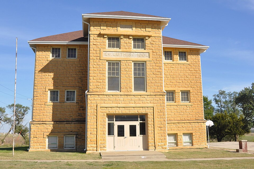
Listed on the National Register of Historic Places in 2015.
One of 15 National Register listings published here for Lincoln County · listed in 2015 · category: Building.
Sources: the National Register database, National Park Service
Regional context, not property-specific evidence. The federal wildfire occurrence database lists 2 fires within 5 miles of Evangelical Lutheran School between 2009 and 2015, burning about 5,354 acres in total. None started naturally. None was recorded as arson. Distance is straight-line from the map coordinates, so a fire counted here may appear on a neighbouring settlement's page as well.
| Reported cause | Fires |
|---|---|
| Missing data/not specified/undetermined | 2 |
The most recent of them, most recent first, with the day each was reported and the service that recorded it.
| Date | Cause | Size | Reported by | Name on the report |
|---|---|---|---|---|
| 8 April 2009 | Missing data/not specified/undetermined | 5,350 acres | Kansas Counties | LINCOLN COUNTY COMPLEX |
| 15 March 2015 | Missing data/not specified/undetermined | 4.0 acres | Kansas Forest Service | 72015 |
Regional context, not property-specific evidence. The National Weather Service names Sylvan Grove, the town this property stands in, in 134 storm reports between 1993 and 2025: 59 hail, 59 thunderstorm wind, 8 tornado, 4 flash flood. No death or injury is recorded in these reports. Each account below is quoted exactly as the forecast office filed it, from the NOAA Storm Events Database, and each date opens the federal record of that event.
| When | Event | Place named | Harm | What the report says |
|---|---|---|---|---|
| May 2007 | Flash Flood | Sylvan Grove | $175,000 | Flash flooding was reported across the county. Street flooding was reported in Sylvan Grove. Damage was estimated at $175,000. |
| April 2015 | Tornado (EF1) | Sylvan Grove | $150,000 | The roof was peeled off of the high school gymnasium (DI16 DOD5) and the press box at the football stadium was completely demolished. The tornado was 40 yards wide. |
| August 2021 | Thunderstorm Wind | Sylvan Grove | $50,000 | A guide wire to a hay barn was snapped. The hay barn was blown over by the wind. |
| May 1993 | Tornado (F0) | Sylvan Grove | $50,000 | This tornado did light damage to three farmsteads, destroyed a few fences, but remained generally over open country. It passed just to the west of Hunter and was headed for Tipton until it dissipated about 1820 CST two miles southeast of Tipton. |
| June 2011 | Thunderstorm Wind | Sylvan Grove | $40,000 | Winds estimated between 70 and 80 mph destroyed a barn over far western portions of the county. The barn's location is estimated. Several other reports of damage (locations unknown) occurred across the county, including heavily damaged outbuildings and windmills, and damaged or uprooted trees. The Lincoln Sentinel-Republican contributed to this report. |
| October 2021 | Lightning | Sylvan Grove | $10,000 | Lightning struck the water tower in Sylvan Grove which led to the issuance of a boil water advisory for the town. Time is estimated based on radar data. |
| June 2013 | Thunderstorm Wind | Sylvan Grove | $10,000 | Roof and tree damage occurred. |
| August 2009 | Thunderstorm Wind | Sylvan Grove | $6,000 | The strong winds knocked numerous small tree and limbs. In Vesper, a 100 year old tree was completely uprooted. |
| August 2021 | Thunderstorm Wind | Sylvan Grove | $5,000 | A power pole was snapped. Power was reported out in Sylvan Grove, Kansas. |
| August 2001 | Tornado (F0) | Sylvan Grove | $5,000 | Windmill damaged. |
| April 1994 | Thunderstorm Wind | Sylvan Grove | $5,000 | no account filed |
| July 1994 | Thunderstorm Wind | Sylvan Grove | $5,000 | no account filed |
| April 1994 | Hail | Sylvan Grove | $500 | no account filed |
| July 1994 | Thunderstorm Wind | Sylvan Grove | $500 | no account filed |
| August 2008 | Flood | Sylvan Grove | $100 | Water was reported half way across HIghway 181 at highway marker 13. Creeks and waterways in the area ran near bank full. |
| May 2024 | Thunderstorm Wind | Sylvan Grove | - | Wind gusts were estimated to be around 70 mph. |
| July 2024 | Thunderstorm Wind | Sylvan Grove | - | Trained spotter reported an estimated gust of 70 mph. |
| June 2022 | Tornado (EFU) | Sylvan Grove | - | Brief touchdown in open country. |
| April 2021 | Thunderstorm Wind | Sylvan Grove | - | The Fire department reported the gust. |
| May 2021 | Heavy Rain | Sylvan Grove | - | This is a 24 hour rainfall total of 4.20 inches. |
| August 2021 | Thunderstorm Wind | Sylvan Grove | - | A trained spotter reported the gust. |
| August 2021 | Thunderstorm Wind | Sylvan Grove | - | A trained spotter measured the gust on a home weather station. |
| August 2021 | Thunderstorm Wind | Sylvan Grove | - | This was an estimated gust. |
| August 2021 | Thunderstorm Wind | Sylvan Grove | - | A power pole was reported down. |
| August 2021 | Thunderstorm Wind | Sylvan Grove | - | A tree was blown down 3 miles west of Sylvan Grove. |
| June 2020 | Hail | Sylvan Grove | - | Large amount of ping pong ball sized hail. |
| July 2020 | Thunderstorm Wind | Sylvan Grove | - | Public report via Twitter of a 65 mph wind gust. |
| July 2020 | Thunderstorm Wind | Sylvan Grove | - | Reported by a trained spotter. |
| August 2020 | Thunderstorm Wind | Sylvan Grove | - | This was a measured wind gust. |
| June 2019 | Flash Flood | Sylvan Grove | - | Kiowa Drive, located just west of Sylvan Grove School, was closed. |
| May 2019 | Thunderstorm Wind | Sylvan Grove | - | No damage was reported. |
| July 2018 | Thunderstorm Wind | Sylvan Grove | - | Lincoln county Sheriff reported a shed had been blown over with some damaged power lines in the area. The report was relayed via via NWS Topeka. |
| June 2017 | Hail | Sylvan Grove | - | Heavy rain was also reported. |
| June 2017 | Thunderstorm Wind | Sylvan Grove | - | Reported by a trained spotter. |
| June 2017 | Hail | Sylvan Grove | - | In the area of K181 and Navajo Drive. |
| June 2017 | Thunderstorm Wind | Sylvan Grove | - | Just north of Sylvan Grove on Highway 14. |
| May 2016 | Thunderstorm Wind | Sylvan Grove | - | A trained spotter reported the gust. |
| May 2016 | Thunderstorm Wind | Sylvan Grove | - | No damage was reported. |
| April 2015 | Hail | Sylvan Grove | - | No damage was reported. |
| September 2014 | Thunderstorm Wind | Sylvan Grove | - | Law enforcement reported the gust. |
| June 2014 | Thunderstorm Wind | Sylvan Grove | - | Estimated gust reported by the general public. |
| June 2014 | Thunderstorm Wind | Sylvan Grove | - | Estimated gust reported by trained spotter. |
| September 2014 | Thunderstorm Wind | Sylvan Grove | - | No damage was reported. |
| May 2014 | Hail | Sylvan Grove | - | The hail fell for approximately 3 minutes. |
| July 2013 | Thunderstorm Wind | Sylvan Grove | - | The winds were reported by a trained spotter. |
| July 2013 | Hail | Sylvan Grove | - | Strong winds of 40 to 50 mph were also reported. |
| June 2013 | Thunderstorm Wind | Sylvan Grove | - | Pea-sized hail was also reported. |
| June 2013 | Thunderstorm Wind | Sylvan Grove | - | A building was damaged, but no details have been provided. |
| June 2013 | Thunderstorm Wind | Sylvan Grove | - | Branches, hay bales, and other debris were hurled and sent airborne over and across Highway 18. |
| July 2013 | Hail | Sylvan Grove | - | The golfball-sized hail occurred at the Pike/50th Road intersection. |
| May 2012 | Thunderstorm Wind | Sylvan Grove | - | Gust was estimated and relayed by the Emergency Manager. |
| May 2011 | Thunderstorm Wind | Sylvan Grove | - | Winds were estimated around 65 mph. |
| May 2011 | Thunderstorm Wind | Sylvan Grove | - | Winds were estimated around 60 mph. |
| May 2011 | Flash Flood | Sylvan Grove | - | Several rounds of thunderstorms over north-central Kansas from the evening hours on the 19th into the morning hours on the 20th produced very heavy rainfall amounts ranging from 4 to 7 inches across the county. Numerous roads were closed countywide due to high water. In particular, the Spillman Creek west to northwest of Lincoln overflowed its banks, producing widespread flooding in the Denmark area. Any property damage that may have occurred from the flooding is unknown. |
| May 2011 | Thunderstorm Wind | Sylvan Grove | - | Winds estimated at 60 mph were observed by a trained spotter. |
| May 2011 | Tornado (EF0) | Sylvan Grove | - | Brief Touchdown over open country. |
| June 2011 | Thunderstorm Wind | Sylvan Grove | - | Estimated gust reported by a trained spotter. The gusts persisted for at least 10 minutes. |
| June 2011 | Thunderstorm Wind | Sylvan Grove | - | Estimated gust reported by a trained spotter. The winds lasted about 25 minutes. |
| April 2010 | Flood | Sylvan Grove | - | Some street flooding occurred across the town of Lincoln. Secondary roads across the county were more than likely impacted by sporadic areas of high water. Creeks near Lincoln ran near bankfull. Any potential property or crop damage that may have occurred is unknown. |
| April 2010 | Hail | Sylvan Grove | - | The golfball size hail was driven by 55 mph winds. |
No historic map-sheet match is published for this property yet. That does not mean no map exists. This record needs a coordinate-quality review before it can be joined to a sheet boundary. Browse the county's mapped places while that work is pending.
Other National Register properties close enough to walk or drive between, ordered by distance from this one. Both positions come from the same geocoding pass that matched these properties to their map sheets.
| Photograph | Property | Distance | Listed |
|---|---|---|---|
| Behrhorst Brothers Hardware | 0.4 miles | 2022 | |
 | Nielsen Farm | 6.9 miles | 2006 |
 | Bullfoot Creek Bridge | 7.4 miles | 1985 |
 | Danske Evangelist Lutheran Kirke | 7.8 miles | 1991 |
| National Archives record | The nomination case file for reference 15000690 in Record Group 79. |
| Lincoln County | All 15 listed properties in this county. |