 Block
From the record
15 National Register listings published here.
Sources: the National Register database, National Park Service
62 topographic sheets cover 17 settlements here, and 15 properties are on the National Register of Historic Places.
15 National Register listings published here.
Sources: the National Register database, National Park Service
Every property in this county listed on the National Register of Historic Places, with the year it was listed and the federal nomination document.
| Photograph | Property | Type | Listed | Reference |
|---|---|---|---|---|
| Behrhorst Brothers Hardware | building | 2022 | 100008289 | |
 | Bullfoot Creek Bridge | structure | 1985 | 85001421 |
 | Cummins Block Building | building | 2000 | 00000268 |
 | Danske Evangelist Lutheran Kirke | building | 1991 | 91001154 |
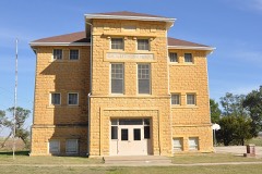 | Evangelical Lutheran School | building | 2015 | 15000690 |
| Felcman, Frank & Anna Homestead | building | 2024 | 100011116 | |
 | Lincoln Carnegie Library | building | 1987 | 87000957 |
| Lincoln City Park | district | 2020 | 100005124 | |
 | Lincoln County Courthouse | building | 1976 | 76000825 |
| Lincoln Downtown Historic District | district | 2020 | 100005123 | |
| Lincoln High School | building | 2020 | 100004204 | |
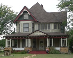 | Marshall-Yohe House | building | 2001 | 01000386 |
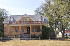 | Nielsen Farm | building | 2006 | 05001513 |
 | Salt Creek Truss Leg Bedstead Bridge | structure | 2003 | 03000368 |
 | Spring Creek Tributary Bridge | structure | 1985 | 85001440 |
Every wildfire the federal occurrence database records inside this county: 19 of them, burning about 14,773 acres. 1 started naturally and none was recorded as arson. Each settlement page carries the fires within five miles of it.
| Reported cause | Fires |
|---|---|
| Missing data/not specified/undetermined | 10 |
| Equipment and vehicle use | 4 |
| Debris and open burning | 4 |
| Natural | 1 |
The five largest, by the area the report gives. None of them was recorded as arson.
| Date | Cause | Size | Reported by | Name on the report |
|---|---|---|---|---|
| 8 April 2009 | Missing data/not specified/undetermined | 5,350 acres | Kansas Counties | LINCOLN COUNTY COMPLEX |
| 7 April 2009 | Missing data/not specified/undetermined | 3,840 acres | Kansas Counties | ROSEBROOK |
| 9 June 2012 | Missing data/not specified/undetermined | 2,000 acres | Kansas Counties | SYLVAN |
| 25 March 2011 | Missing data/not specified/undetermined | 2,000 acres | Kansas Counties | STEVE DILLON |
| 30 October 2010 | Missing data/not specified/undetermined | 640 acres | Kansas Counties | BARNARD |
| 19 April 2019 | Missing data/not specified/undetermined | 550 acres | Mitchell County | 360 RD |
| 28 November 2014 | Missing data/not specified/undetermined | 300 acres | Ellsworth County | COUNTY LINE |
| 25 January 2018 | Debris and open burning | 40 acres | Kansas Forest Service | 18037 |
Every settlement page carries the fires within five miles of it - see the settlement index below.
The NOAA Storm Events Database holds 627 reports for this county, causing no deaths, 2 injuries and about $2,501,950 in recorded property damage. Each settlement page carries the reports that name it.
| Kind of event | Reports |
|---|---|
| Hail | 322 |
| Thunderstorm Wind | 234 |
| Tornado | 33 |
| Flash Flood | 15 |
| Flood | 12 |
| Heavy Rain | 9 |
| Lightning | 2 |
The most serious of them, by death, then injury, then recorded damage. The accounts are quoted exactly as the forecast office filed them.
| When | Event | Place named | Harm | What the report says |
|---|---|---|---|---|
| October 1956 | Tornado (F3) | not stated | 2 hurt, $250,000 | no account filed |
| December 2016 | Thunderstorm Wind | Beverly | $500,000 | A roof was blown off a barn. |
| July 1956 | Tornado (F3) | not stated | $250,000 | no account filed |
| May 2007 | Flash Flood | Sylvan Grove | $175,000 | Flash flooding was reported across the county. Street flooding was reported in Sylvan Grove. Damage was estimated at $175,000. |
| April 2015 | Tornado (EF1) | Sylvan Grove | $150,000 | The roof was peeled off of the high school gymnasium (DI16 DOD5) and the press box at the football stadium was completely demolished. The tornado was 40 yards wide. |
| May 2007 | Tornado (EF1) | Westfall | $125,000 | The tornado damaged a few barns, sheds, and downed several power lines. |
| August 2006 | Thunderstorm Wind | Lincoln | $125,000 | City is without power. Roof damage was reported and some windows were blown out. |
| August 2002 | Hail | Lincoln | $100,000 | Widespread damage to homes and vehicles. |
| September 2003 | Flash Flood | North Portion | $84,000 | Torrential rains, on the order of 2-4 inches per hour, caused flash flooding across approximately 108 square miles, primarily in Cedron and Orange townships as well as parts of Battle Creek, Hanover, and Grant townships. Land damage acreage: 26,250. Included in this affected acreage were 2,560 acres of milo and 640 acres of soybeans. Farm facilities damaged: 25 dams and 10 miles of fencing. Narrative provided by USDA Flash Situation Report. |
| June 2011 | Thunderstorm Wind | Lincoln | $60,000 | Emergency management reported quite a bit of tree damage in and around Lincoln. Additionally, newspaper reports indicated a large 140,000 bushel grain bin was destroyed along with other grain storage damaged in Lincoln. Furthermore, some power poles were snapped just west of Lincoln. Information courtesy of the Lincoln Sentinel-Republican. |
| August 2021 | Thunderstorm Wind | Sylvan Grove | $50,000 | A guide wire to a hay barn was snapped. The hay barn was blown over by the wind. |
| September 2009 | Hail | Westfall | $50,000 | The baseball sized hail produced a swath of damage a mile wide, destroying crops and vehicles in its path. |
| April 2001 | Tornado (F0) | Lincoln | $50,000 | Minor damage to one home as well as a few trees. |
| May 1998 | Thunderstorm Wind | Lincoln | $50,000 | Widespread tree damage, including a large tree falling onto a truck. Roofs were damaged to several businesses including one restaurant. |
| May 1993 | Tornado (F0) | Sylvan Grove | $50,000 | This tornado did light damage to three farmsteads, destroyed a few fences, but remained generally over open country. It passed just to the west of Hunter and was headed for Tipton until it dissipated about 1820 CST two miles southeast of Tipton. |
| August 2009 | Thunderstorm Wind | Lincoln | $45,000 | Measured wind gusts to 58 mph...produced wind damage to several structures across town. A building supply company received damage to its tin roof. A door was pulled from its frame and the glass broken at another business. A 100 year old building formerly a livery stable was nearly blown over and was later demolished, after the framework and foundation were rendered unstable. Numerous other small to large trees were also downed. |
| June 2011 | Thunderstorm Wind | Sylvan Grove | $40,000 | Winds estimated between 70 and 80 mph destroyed a barn over far western portions of the county. The barn's location is estimated. Several other reports of damage (locations unknown) occurred across the county, including heavily damaged outbuildings and windmills, and damaged or uprooted trees. The Lincoln Sentinel-Republican contributed to this report. |
| May 2015 | Tornado (EF0) | Lincoln | $25,000 | Multiple vortex tornado moved to the northeast across open country. Minor damage was noted at one farmstead when a sheet metal roof was blown across the road (DI1 DOD2). Otherwise, minor tree damage occurred sporadically along the path. Several cedar trees were snapped in the cemetery on the east side of Lincoln. The tornado was 100 yards wide. |
| June 2013 | Thunderstorm Wind | Ash Grove | $25,000 | A wind generator was destroyed. |
| September 2009 | Hail | Beverly | $25,000 | The golfball sized hail damaged crops and vehicles along its mile wide path. The damage was the most extensive in Beverly. |
| May 1970 | Tornado (F2) | not stated | $25,000 | no account filed |
| May 1970 | Tornado (F1) | not stated | $25,000 | no account filed |
| June 2013 | Thunderstorm Wind | Ash Grove | $20,000 | One side of a building was torn off. The details as to building type are unknown at this time. |
| June 2013 | Thunderstorm Wind | Ash Grove | $20,000 | A roof was torn off a building. The details as to building type are unknown at this time. |
| August 2009 | Thunderstorm Wind | Westfall | $13,000 | A tractor trailer was blown into the center median at mile marker 233 along Interstate 70. Several three inch tree limbs were blown out of trees as well. |
| July 1995 | Thunderstorm Wind | Westfall | $12,000 | One tree was blown onto the top of a house and the roof was blown off of a grain elevator. |
| October 2021 | Lightning | Sylvan Grove | $10,000 | Lightning struck the water tower in Sylvan Grove which led to the issuance of a boil water advisory for the town. Time is estimated based on radar data. |
| June 2013 | Thunderstorm Wind | Vesper | $10,000 | Roof and tree damage was reported. |
| June 2013 | Thunderstorm Wind | Sylvan Grove | $10,000 | Roof and tree damage occurred. |
| June 2011 | Flood | Ash Grove | $10,000 | Very heavy rainfall amounts on the order of 2 to nearly 4 inches from the evening on the 1st into the overnight hours produced widespread flooding across Lincoln county through the evening on the 3rd. In addition to numerous roads being closed countywide due to high water, flooding was fairly widespread along the swollen Salt Creek near Barnard, and the Saline River and Spillman creek near Lincoln and Denmark. Furthermore, the swollen Bullfoot creek produced 5 feet of water in a residence's basement; this is the only known property damage produced by the flooding. The flooding also caused widespread damage to Lincoln County crops, but crop monetary losses are unknown. The Lincoln Sentinel-Republican contributed to this report. |
| September 2010 | Thunderstorm Wind | Westfall | $10,000 | The highway patrol reported tractor trailers blown over along Interstate 70. |
| April 2003 | Thunderstorm Wind | Lincoln | $10,000 | Unspecified barn and tree damage. |
| April 2001 | Thunderstorm Wind | Lincoln | $10,000 | Power lines blown down. (Reported by KRSL Radio.) |
| August 2009 | Thunderstorm Wind | Sylvan Grove | $6,000 | The strong winds knocked numerous small tree and limbs. In Vesper, a 100 year old tree was completely uprooted. |
| August 2021 | Thunderstorm Wind | Sylvan Grove | $5,000 | A power pole was snapped. Power was reported out in Sylvan Grove, Kansas. |
| June 2013 | Thunderstorm Wind | Lincoln | $5,000 | Power lines and power poles were downed across the city of Lincoln extending east to near the Shady Bend area. |
| June 2013 | Thunderstorm Wind | Ash Grove | $5,000 | The winds downed power lines. The time of occurrence was estimated from radar. |
| February 2007 | Hail | Westfall | $5,000 | Pea to marble size hail accumulated up to two feet deep, and combined with 50 mph winds to strip paint from a camping trailer. |
| May 2002 | Tornado (F0) | Beverly | $5,000 | Shed damaged. |
| August 2001 | Tornado (F0) | Sylvan Grove | $5,000 | Windmill damaged. |
| August 1999 | Thunderstorm Wind | Lincoln | $5,000 | Power lines blown down. |
| July 1994 | Thunderstorm Wind | Lincoln | $5,000 | Winds of 50 to 75 miles an hour lasted nearly an hour and broke a plate glass window and knocked down some power lines. |
| July 1994 | Thunderstorm Wind | Lincoln | $5,000 | Utility poles were blown down in town. |
| July 1994 | Thunderstorm Wind | Denmark | $5,000 | Winds up to 70 miles an hour toppled an emergency services radio repeater tower system. A mile and a half away trees were uprooted and a large tree limb fell on a house. Golf ball-size hail fell two miles south of Ash Grove, while hail the size of mothballs fell at Sylvan Grove. |
| April 1994 | Thunderstorm Wind | Sylvan Grove | $5,000 | no account filed |
| July 1994 | Hail | Alton | $5,000 | no account filed |
| July 1994 | Thunderstorm Wind | Sylvan Grove | $5,000 | no account filed |
| October 2007 | Flash Flood | Lincoln | $3,000 | Flash flooding stalled cars in Lincoln. Water rose up to 2 feet above bridges with 2 city streets barricaded. Flooding came within 100 feet of the Lincoln Junior/Senior High School. Sand bagging also occurred around 2 homes. One of the homes was evacuated. While 3.80 inches of rainfall fell across the area in less than 2 hours. |
| October 2007 | Lightning | Lincoln | $3,000 | Lightning struck the Lincoln County Courthouse, loosening shingles from the historic building spire and damaging computers inside. |
| May 1962 | Tornado | not stated | $2,500 | no account filed |
| July 2012 | Thunderstorm Wind | Barnard | $2,000 | Two large trees blown down three miles west of Barnard. |
| May 2007 | Thunderstorm Wind | Westfall | $2,000 | Larege tree limbs were blown down. |
| August 2009 | Thunderstorm Wind | Denmark | $1,000 | The strong winds knocked down some trees and tree limbs. |
| June 2022 | Flash Flood | Lincoln | $500 | Law enforcement reported several rural road closures due to high water. |
| August 2010 | Thunderstorm Wind | Lincoln | $500 | A trained spotter reported several small tree limbs down. Also a 12 to 14 inch diameter tree was blown down. |
| August 2009 | Thunderstorm Wind | Barnard | $500 | Tree limbs were downed. |
| April 1994 | Hail | Sylvan Grove | $500 | no account filed |
| July 1994 | Thunderstorm Wind | Sylvan Grove | $500 | no account filed |
| May 1993 | Hail | Linclon | $500 | no account filed |
| June 2022 | Flash Flood | Lincoln | $100 | Water was reported running over Kansas Highway 14. |
The Survey's mineral resources record lists 2 workings inside this county. All of them still produce. Each settlement page carries the workings within five miles of it.
| Commodity | Workings |
|---|---|
| Stone, Crushed/Broken | 2 |
The least common of them first, because a county's hundredth gravel pit says nothing its first ten did not.
| Where | Site | Commodity | Status | Recorded |
|---|---|---|---|---|
| Lewick-Molloy Quarry & Mill | Stone, Crushed/Broken | Producer | ||
| Wilson Ryan Quarry & Mill | Stone, Crushed/Broken | Producer |
Named settlements recorded in the Geographic Names Information System, each with the topographic sheets covering it. Villages, hamlets and abandoned places alike. Each is shown with the nearest named watercourse or landform and the survey quadrangle it falls on.
Salt Creek township · 67418 · On Rattlesnake Creek · Barnard quadrangle
13 sheets, 1894 to 1985
Marion township · 67455 · On Little Timber Creek · Lincoln quadrangle
12 sheets, 1894 to 1985
Elkhorn township · 67455 · On Beaver Creek · Shady Bend quadrangle
12 sheets, 1894 to 1985
Colorado township · 67455 · On Twelvemile Creek · Shady Bend quadrangle
12 sheets, 1894 to 1985
Pleasant township · 67481 · On West Twin Creek · Sylvan Grove quadrangle
12 sheets, 1894 to 1985
Pleasant township · 67481 · On Blue Stem Creek · Sylvan Grove quadrangle
12 sheets, 1894 to 1985