 Block
From the record
One of 10 National Register listings published here for Sumner County · listed in 1971 · category: Building · built in 1885, Gothic Revival.
Sources: the National Register database, National Park Service · the Wikipedia article
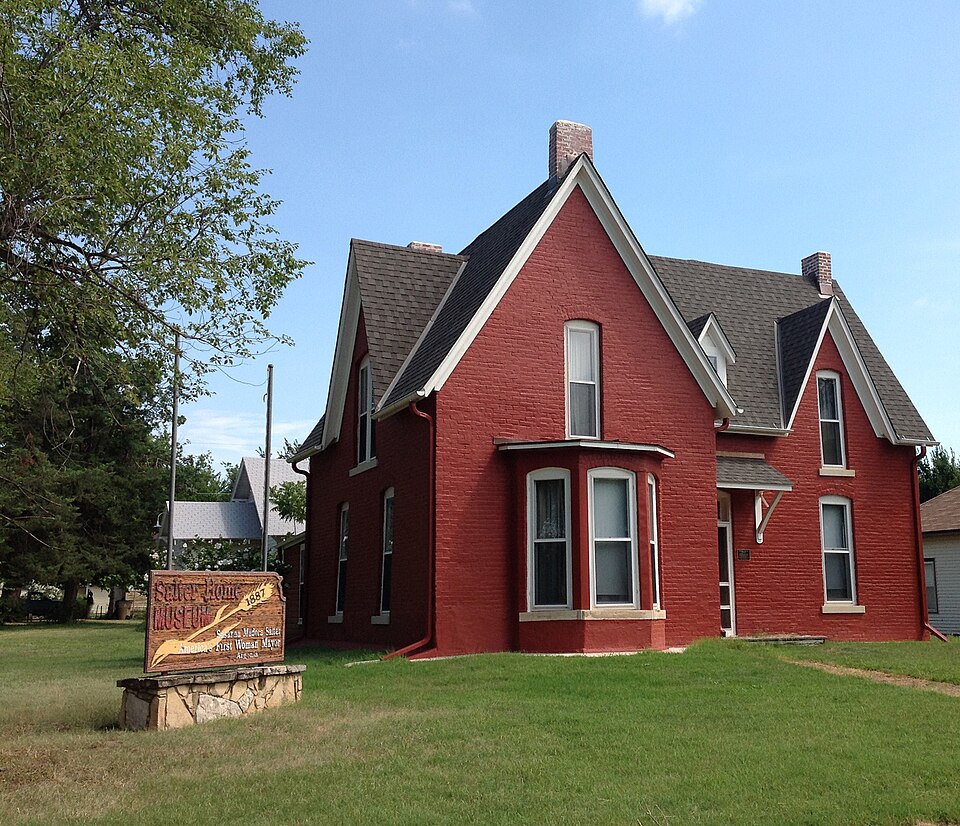
Built in 1885 (Gothic Revival). Listed on the National Register of Historic Places in 1971.
One of 10 National Register listings published here for Sumner County · listed in 1971 · category: Building · built in 1885, Gothic Revival.
Sources: the National Register database, National Park Service · the Wikipedia article
Regional context, not property-specific evidence. The federal wildfire occurrence database lists 34 fires within 5 miles of Salter House between 2015 and 2020, burning about 115 acres in total. 2 started naturally. 2 were recorded as arson. Distance is straight-line from the map coordinates, so a fire counted here may appear on a neighbouring settlement's page as well.
| Reported cause | Fires |
|---|---|
| Missing data/not specified/undetermined | 15 |
| Debris and open burning | 14 |
| Arson/incendiarism | 2 |
| Natural | 2 |
| Equipment and vehicle use | 1 |
The most recent of them, most recent first, with the day each was reported and the service that recorded it.
| Date | Cause | Size | Reported by | Name on the report |
|---|---|---|---|---|
| 28 September 2015 | Missing data/not specified/undetermined | 15 acres | Kansas Forest Service | 1500045 |
| 26 September 2018 | Debris and open burning | under an acre | Kansas Forest Service | 18022 |
| 18 September 2017 | Debris and open burning | under an acre | Sumner County | 17035 |
| 18 September 2015 | Missing data/not specified/undetermined | under an acre | Kansas Forest Service | 1500043 |
| 30 August 2018 | Natural | under an acre | Kansas Forest Service | 18020 |
| 28 July 2017 | Debris and open burning | under an acre | Sumner County | 17029 |
| 27 July 2015 | Debris and open burning | under an acre | Kansas Forest Service | 1500039 |
| 22 July 2017 | Arson/incendiarism | under an acre | Sumner County | 17028 |
Regional context, not property-specific evidence. The National Weather Service names Argonia, the town this property stands in, in 61 storm reports between 1994 and 2022: 29 hail, 20 thunderstorm wind, 7 tornado, 2 flood. The reports record 1 death. Each account below is quoted exactly as the forecast office filed it, from the NOAA Storm Events Database, and each date opens the federal record of that event.
| When | Event | Place named | Harm | What the report says |
|---|---|---|---|---|
| September 2008 | Flood | Argonia | 1 killed, $10,000 | Raging water along the Chikaskia River caused 5 teenagers to become trapped, as they were rafting down the river. The water rescue that followed lead to 3 emergency workers ending up in the water along with the stranded teenagers. A volunteer firefighter then attempted to make an individual rescue, but lost his balance, and was swept under by the strong current. The man later died from injuries sustained during the rescue. |
| July 2013 | Thunderstorm Wind | Argonia | $900,000 | Sumner County Emergency Management reported that the roofs were torn off both the Argonia High School and the elementary school. There was also extensive damage to trees, power lines and power poles. The estimated time of when the damage occurred was from 1640 to 1650. |
| May 2004 | Tornado (F1) | Argonia | $250,000 | The following were damaged: the roof of one home, several outbuildings, and the adjacent wheat fields. |
| May 2004 | Tornado (F1) | Argonia | $100,000 | Tornado mainly moved over open country shredding trees. However, one roof was completely destroyed. |
| June 1997 | Tornado (F0) | Argonia | $75,000 | ONE LARGE BARN DESTROYED ALONG WITH SOME FARM EQUIPMENT. |
| July 2013 | Thunderstorm Wind | Argonia | $15,000 | Transmission lines and power poles were blown down. |
| July 2013 | Thunderstorm Wind | Argonia | $10,000 | Power lines were blown down on Main Street. The time of occurrence is based on radar. |
| July 2001 | Thunderstorm Wind | Argonia | $10,000 | Carport blown down. |
| July 2013 | Thunderstorm Wind | Argonia | $5,000 | The Sumner County Sheriff reported Highway 160 was blocked by uprooted trees. The diameters of the trunks was unknown. |
| June 2010 | Thunderstorm Wind | Argonia | $2,000 | Some minor roof damage was reported. |
| March 2008 | Thunderstorm Wind | Argonia | $1,000 | Several tree limbs were downed in the town of Argonia. |
| April 1994 | Hail | Argonia | $500 | no account filed |
| March 2022 | Hail | Argonia | - | A public report of quarter sized hail. |
| April 2019 | Hail | Argonia | - | Report relayed via KAKE television. |
| August 2017 | Thunderstorm Wind | Argonia | - | Measured at the elementary school. |
| June 2014 | Flood | Argonia | - | Several streets were flooded in Argonia. |
| July 2013 | Thunderstorm Wind | Argonia | - | No damage was reported. |
| April 2012 | Tornado (EF3) | Argonia | - | A two story house was completely removed from foundation and had landed on top of a three car garage. The basement is all that remained. Cars that were in the garage lost windows and one was dented on the one side. A fifth wheel camper was thrown 100 yards with only a split in the frame and wheels remaining. The top portion was only small pieces. ||This tornado continued on to the NNE and a roof was completely torn off of the home. All of the windows were blown out. Outbuildings were demolished. Large trees were uprooted. Objects were embedded into the house and trees including a twig into a tree, a 2x4 blown into an interior wall on the main part of the house. The porch was gone. |
| June 2010 | Heavy Rain | Argonia | - | THE COOP observer measured 3.87 inches of rainfall. Some minor flooding was also reported. |
| June 2010 | Heavy Rain | Argonia | - | The COOP observer reported 5.06 inches of rainfall overnight. |
| May 2009 | Hail | Argonia | - | Winds of 50 to 55 mph occurred with the hail. |
| June 2008 | Thunderstorm Wind | Argonia | - | The Wind gust was measured at the KSNW weather lab at Argonia Elementary School. |
| May 2002 | Tornado (F0) | Argonia | - | Occurred in open country. |
| April 2002 | Thunderstorm Wind | Argonia | - | Tree damage. |
| June 2001 | Tornado (F0) | Argonia | - | Occurred along Highway 44 from Blackstone Rd. to S Argonia Rd. Also reported by Harper County sheriff. |
| June 2001 | Tornado (F0) | Argonia | - | Occurred in open country. |
| July 1999 | Flash Flood | Argonia | - | Torrential rains flooded many roads including Highway 81 which was closed. |
| May 2022 | Hail | Argonia | - | no account filed |
| August 2017 | Hail | Argonia | - | no account filed |
| July 2013 | Hail | Argonia | - | no account filed |
| June 2010 | Hail | Argonia | - | no account filed |
| May 2010 | Hail | Argonia | - | no account filed |
| May 2009 | Hail | Argonia | - | no account filed |
| May 2009 | Thunderstorm Wind | Argonia | - | no account filed |
| March 2008 | Thunderstorm Wind | Argonia | - | no account filed |
| March 2008 | Hail | Argonia | - | no account filed |
| April 2004 | Hail | Argonia | - | no account filed |
| March 2002 | Hail | Argonia | - | no account filed |
| April 2002 | Hail | Argonia | - | no account filed |
| June 2002 | Hail | Argonia | - | no account filed |
| May 2002 | Hail | Argonia | - | no account filed |
| April 2002 | Hail | Argonia | - | no account filed |
| April 2002 | Thunderstorm Wind | Argonia | - | no account filed |
| May 2002 | Hail | Argonia | - | no account filed |
| May 2002 | Hail | Argonia | - | no account filed |
| April 2001 | Hail | Argonia | - | no account filed |
| April 2001 | Thunderstorm Wind | Argonia | - | no account filed |
| May 2001 | Hail | Argonia | - | no account filed |
| May 2001 | Hail | Argonia | - | no account filed |
| October 2001 | Thunderstorm Wind | Argonia | - | no account filed |
| October 2001 | Hail | Argonia | - | no account filed |
| April 1998 | Thunderstorm Wind | Argonia | - | no account filed |
| June 1997 | Thunderstorm Wind | Argonia | - | no account filed |
| May 1996 | Hail | Argonia | - | no account filed |
| June 1996 | Hail | Argonia | - | no account filed |
| June 1996 | Hail | Argonia | - | no account filed |
| June 1996 | Thunderstorm Wind | Argonia | - | no account filed |
| June 1996 | Hail | Argonia | - | no account filed |
| June 1996 | Thunderstorm Wind | Argonia | - | no account filed |
| June 1996 | Hail | Argonia | - | no account filed |
No historic map-sheet match is published for this property yet. That does not mean no map exists. This record needs a coordinate-quality review before it can be joined to a sheet boundary. Browse the county's mapped places while that work is pending.
| National Archives record | The nomination case file for reference 71000332 in Record Group 79. |
| Wikipedia article | Community-written account of this property, licensed CC BY-SA. |
| Sumner County | All 10 listed properties in this county. |