 Block
From the record
10 National Register listings published here.
Sources: the National Register database, National Park Service
51 topographic sheets cover 35 settlements here, and 10 properties are on the National Register of Historic Places.
10 National Register listings published here.
Sources: the National Register database, National Park Service
Every property in this county listed on the National Register of Historic Places, with the year it was listed and the federal nomination document.
| Photograph | Property | Type | Listed | Reference |
|---|---|---|---|---|
 | Bartlett Arboretum | district | 2010 | 10000180 |
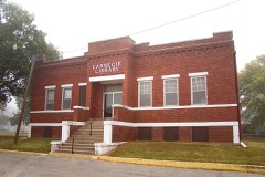 | Caldwell Carnegie Library | building | 1983 | 83000443 |
| Grocery/Drugs/Dry Goods/Millinery | building | 2007 | 07000600 | |
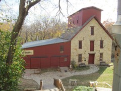 | Old Oxford Mill | building | 1982 | 82002677 |
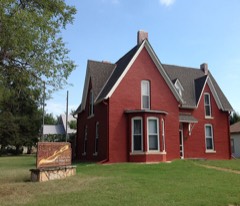 | Salter House | building | 1971 | 71000332 |
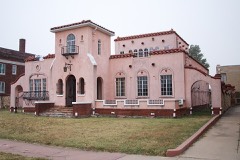 | Edwin Smith House | building | 2004 | 04000450 |
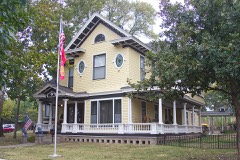 | H.F. Smith House | building | 2007 | 07000318 |
| Spring Creek School | building | 1997 | 97000410 | |
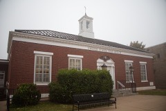 | US Post Office-Caldwell | building | 1989 | 89001635 |
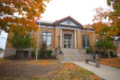 | Wellington Carnegie Library | building | 1987 | 87000973 |
Every wildfire the federal occurrence database records inside this county: 417 of them, burning about 5,408 acres. 8 started naturally and 11 were recorded as arson. Each settlement page carries the fires within five miles of it.
| Reported cause | Fires |
|---|---|
| Missing data/not specified/undetermined | 201 |
| Debris and open burning | 128 |
| Equipment and vehicle use | 37 |
| Smoking | 13 |
| Arson/incendiarism | 11 |
| Recreation and ceremony | 9 |
| Natural | 8 |
| Misuse of fire by a minor | 3 |
| Power generation/transmission/distribution | 3 |
| Fireworks | 3 |
| Other causes | 1 |
The five largest, by the area the report gives. None of them was recorded as arson.
| Date | Cause | Size | Reported by | Name on the report |
|---|---|---|---|---|
| 11 April 2001 | Missing data/not specified/undetermined | 810 acres | Pawnee Agency | CHILOCO |
| 30 December 2016 | Debris and open burning | 600 acres | Kansas Forest Service | 1244 |
| 17 March 2016 | Debris and open burning | 500 acres | Kansas Forest Service | 249 |
| 14 June 2020 | Equipment and vehicle use | 350 acres | Kansas Forest Service | not named |
| 22 March 2015 | Debris and open burning | 160 acres | Kansas Forest Service | 268 |
| 17 February 2016 | Missing data/not specified/undetermined | 130 acres | Kansas Forest Service | 1607 |
| 21 March 2015 | Missing data/not specified/undetermined | 120 acres | Kansas Forest Service | 106 |
| 24 January 2018 | Missing data/not specified/undetermined | 100 acres | Kansas Forest Service | 86 |
Every settlement page carries the fires within five miles of it - see the settlement index below.
The NOAA Storm Events Database holds 1,144 reports for this county, causing 6 deaths, 14 injuries and about $45,180,400 in recorded property damage. Each settlement page carries the reports that name it.
| Kind of event | Reports |
|---|---|
| Hail | 553 |
| Thunderstorm Wind | 421 |
| Tornado | 89 |
| Flash Flood | 40 |
| Flood | 30 |
| Heavy Rain | 9 |
| Lightning | 2 |
The most serious of them, by death, then injury, then recorded damage. The accounts are quoted exactly as the forecast office filed them.
| When | Event | Place named | Harm | What the report says |
|---|---|---|---|---|
| May 1955 | Tornado (F5) | not stated | 5 killed, 3 hurt, $250,000 | no account filed |
| September 2008 | Flood | Argonia | 1 killed, $10,000 | Raging water along the Chikaskia River caused 5 teenagers to become trapped, as they were rafting down the river. The water rescue that followed lead to 3 emergency workers ending up in the water along with the stranded teenagers. A volunteer firefighter then attempted to make an individual rescue, but lost his balance, and was swept under by the strong current. The man later died from injuries sustained during the rescue. |
| May 1999 | Tornado (F1) | Wellington | 4 hurt, $750,000 | Initial touchdown occurred 4 miles north of Wellington in Central Sumner County where several power poles were knocked down. Moving north-northeast near 30 kts, the tornado inflicted damage to about 15 structures including complete destruction of two mobile homes, a pole barn, two wood sheds and one metal shed. Also damaged were a ranch style home and a metal shed, both of which lost most of their roofing. This tornado was responsible for all 4 injuries in Sumner County. Of the injuries, 3 occurred (1 serious) in the two destroyed mobile homes. While in Sumner County, this tornado possessed a path 10 miles long and 1/4 to 1/2 mile wide. It would exit Sumner County at 1930, continuing a north-northeast track into Sedgwick County. |
| June 2004 | Tornado (F3) | Mulvane | 2 hurt, $500,000 | The tornado started moving NE before becoming influenced by the outflow of the storm and darted back to the SE. The tornado ripped the roof off one home and blew out two walls and a roof of another. However, the tornado took dead aim on one home about 3.5 miles SE of Mulvane and completely removed it from it's foundation. Two inhabitants were under the staircase in the basement and escaped with only minor injuries. |
| March 1965 | Tornado (F4) | not stated | 2 hurt, $250,000 | no account filed |
| November 1960 | Tornado (F2) | not stated | 2 hurt, $250,000 | no account filed |
| May 2004 | Tornado (F3) | Conway Spgs | 1 hurt, $17,750,000 | The following were destroyed: 15 farm dwellings and service buildings, 25 pieces of farm machinery and equipment, many miles of transmission line, with most of wheat a total loss. (This portion of narrative courtesy of USDA Flash Situation Report.) In addition, major damage to several homes along highway 49. One modular was completely removed from over a viewout basement. A teenage boy sought refuge under the staircase in the basement only to watch a car thrown overhead. He escaped unharmed. However, one woman wasn't so fortunate; the resident of a mobile home that was completely destroyed. The only recognizable parts were the steel girders that ran along the base of the home. She had sought refuge in the bathroom and was holding on to the commode. She was thrown several feet from the homestead and received several injuries. Fortunately, none were serious. |
| April 1996 | Thunderstorm Wind | Wellington | $7,000,000 | no account filed |
| March 1990 | Tornado (F3) | not stated | $2,500,000 | no account filed |
| May 2019 | Flash Flood | Wellington | $2,000,000 | Interstate 35 or the Kansas Turnpike was closed due the Slate Creek reaching record levels and overflowing the highway at mile marker 21. The interstate was closed for hours, as crews waited for the water to recede and repair work to occur. Traffic was diverted at the Wellington exit and had to use an alternate until it reached the Kansas Oklahoma line. The Kansas Turnpike Authority said that closing that long of a stretch of the Turnpike had not occurred in 30 years. |
| June 1998 | Hail | Wellington | $2,000,000 | Wind-driven golfball-sized hail smashed windows, dented siding and caused widespread roof damage. |
| May 1997 | Tornado (F2) | Perth | $1,850,000 | no account filed |
| May 2004 | Tornado (F3) | Conway Spgs | $1,000,000 | Considerable damage to two homesteads; the first being a sturdy brick home. All exterior walls ripped from the home, only leaving only the interior. Home owner ran down the stairs as the tornado hit and avoided injury. Further southeast, a modular home was completely removed from above a viewout basement. It was here that an amazing survival occurred. The homeowner sought refuge in a safe room in the basement and was unharmed, despite the fact a propane tank landed in the basement and began to leak. Breathing became difficult as fumes permeated the saferoom. At the same time, the saferoom began to flood, however the rising water levels dissipated the fumes. In addition, a semi-truck was thrown approximately 100 feet. |
| June 1998 | Thunderstorm Wind | Caldwell | $1,000,000 | Winds of 70 mph combined with 0.75 inch hail to inflict widespread damage to trees, pwoer lines, homes, and blew roofs off barns, sheds and outbuildings. |
| June 1998 | Hail | Wellington | $1,000,000 | Hail smashed windows to numerous cars and buildings. |
| July 2013 | Thunderstorm Wind | Argonia | $900,000 | Sumner County Emergency Management reported that the roofs were torn off both the Argonia High School and the elementary school. There was also extensive damage to trees, power lines and power poles. The estimated time of when the damage occurred was from 1640 to 1650. |
| August 1997 | Thunderstorm Wind | Mulvane | $500,000 | THREE HOMES SEVERELY DAMAGED, INCLUDING ONE COMPLETELY UNROOFED. NUMEROUS TREES AND POWER POLES BLOWN DOWN RESULTED IN WIDESPREAD POWER OUTAGES. |
| May 2004 | Tornado (F1) | Conway Spgs | $450,000 | Tornado did considerable damage to a couple of roofs and almost wiped out a mobile home. |
| May 2004 | Tornado (F1) | Argonia | $250,000 | The following were damaged: the roof of one home, several outbuildings, and the adjacent wheat fields. |
| August 2004 | Tornado (F2) | Wellington | $250,000 | At intersection of E. 40th St. S and Highway 81, 2 miles south of Wellington, two homes were damaged around 1830 CST. The first, a 2-story brick structure, was unroofed and had one wall collapsed. (F2 rating assigned to this property.) Tree damage also occurred on & around the property. The 2nd, neighboring home, of wood frame construction, was located 30 feet distant, and sustained minor roof damag. (F0 rating assigned to this property.) In addition, four power poles were snapped to near the ground as were, of course, their associated power lines. |
| May 1999 | Tornado (F1) | Mayfield | $250,000 | Minor roof damage inflicted to a business in Mayfield. Just north of Mayfield, a metal outbuilding was partially unroofed with minor roof damage inflicted to the adjacent house. The tornado then hit a farmstead where windows were broken on the south and west sides of the house, a satellite dish tilted over, two metal grain bins removed and a metal barn damaged when one of the grain bins was thrown into it. Near termination, major damage was inflicted to two mobile homes, one of which was thrown about 50 feet and destroyed on impact with a row of trees. |
| March 1991 | Tornado (F3) | not stated | $250,000 | no account filed |
| May 1969 | Tornado (F1) | not stated | $250,000 | no account filed |
| May 1965 | Tornado (F3) | not stated | $250,000 | no account filed |
| May 1965 | Tornado (F3) | not stated | $250,000 | no account filed |
| May 1955 | Tornado (F5) | not stated | $250,000 | no account filed |
| May 2019 | Flash Flood | Riverdale | $200,000 | Kansas Department of Transportation reported the Kansas Turnpike (Interstate 35) was closed from the Wichita Toll booth the the Wellington exit due to flooding. |
| April 2009 | Flood | Geuda Spgs | $200,000 | Continued runoff from very heavy rainfall during the afternoon, evening and overnight hours on the 26th prolonged flooding across Sumner county into the morning hours on the 29th, partly due to flooding along swollen rivers and creeks, including the Arkansas, Chikaskia, Ninnescah, and Slate, and their associated tributaries. Several rural and some city roads around the county were closed due to high water, including Highways 81 and 55 near the Ninnescah. A few homes were flooded south of 120th Avenue 2 miles west of Highway 81. Some water rescues were needed across the county. Property damage amounts are rough estimates. The Wellington Daily News contributed to this report. |
| June 2007 | Thunderstorm Wind | Geuda Spgs | $175,000 | Straight line winds caused extensive damage across the Geuda Springs area. Numerous trees and power poles/lines were downed. Several buildings and residences received major damage. The strong winds ripped off the roof of an old school gymnasium. |
| April 2014 | Hail | Mulvane | $160,000 | Hail up to 2 inches in diameter pounded the parking lots of the Kansas Star Casino near Mulvane. Numerous car windshields were busted, with damage to the roof of the casino. |
| July 2008 | Thunderstorm Wind | Corbin | $150,000 | A combination of large hail and microburst straight-line winds caused extensive damage across south-central and southwest portions of Sumner County. At least two outbuildings, one of which was newly constructed, were heavily damaged. A residence sustained roof, siding and window damage, and a few vehicles sustained hail damage. Eight to ten power poles were snapped across the area, and five-inch diameter tree limbs were downed. |
| May 2010 | Tornado (EF1) | Hunnewell | $125,000 | Two semi tractor trailers were blown off of the Kansas Turnpike right at the state line as the tornado crossed the interstate. The overturned semi's temporarily closed Interstate 35 for a short time as they blocked traffic in both directions. The tornado also caused significant tree damage as it moved northeast into rural Sumner County, Kansas. |
| May 2008 | Thunderstorm Wind | Cicero | $125,000 | A semi tractor trailer was over turned on the Kansas Turnpike near mile marker 24. Several flags were blown down that were used for the Memorial Day celebration. |
| July 2013 | Thunderstorm Wind | South Haven | $100,000 | Damage was reported throughout the town with numerous power outages. |
| May 2004 | Tornado (F1) | Argonia | $100,000 | Tornado mainly moved over open country shredding trees. However, one roof was completely destroyed. |
| March 2000 | Thunderstorm Wind | Mulvane | $100,000 | Severe thunderstorm winds gusting to 65kts damaged two mobile home parks. One mobile home was destroyed with two others severely damaged. In addition to law enforcement officials, reports were also received from area newspapers. |
| May 2001 | Thunderstorm Wind | Belle Plaine | $75,000 | Lumber yard had part of roof pulled loose, numerous boards tossed, materials knocked off walls and heavy gate blown open. Fences were blown down all over town as were numerous trees. |
| June 1997 | Tornado (F0) | Argonia | $75,000 | ONE LARGE BARN DESTROYED ALONG WITH SOME FARM EQUIPMENT. |
| May 2019 | Flash Flood | Belle Plaine | $50,000 | Several road were reported underwater, with vehicles stranded south of Belle Plaine. |
| May 2019 | Flash Flood | Mulvane | $50,000 | Mulvane fire and rescue reported multiple water rescues. Swift water rescues occurred near 119th and Webb with one person reported trapped in a vehicle. The person was rescued from the car unharmed. |
| February 2012 | Thunderstorm Wind | Geuda Spgs | $50,000 | Localized winds estimated between 90 and 100 mph extensively damaged a home north of Geuda Springs. The house lost two-thirds of its roof, a wall was bowed out two feet, a large tree was uprooted and a concrete block garage was destroyed. Several power poles were downed across the area as well. |
| July 2003 | Thunderstorm Wind | Wellington | $50,000 | Construction trailer overturned near Wellington Airport, and one shed blown down. Tree damage. The Wellington Daily contributed to this narrative. |
| March 2000 | Thunderstorm Wind | Belle Plaine | $50,000 | Severe thunderstorm winds rolled over one mobile home and blew down numerous tree limbs. |
| June 1998 | Tornado (F0) | Belle Plaine | $50,000 | A few outbuildings damaged. |
| July 1998 | Lightning | South Haven | $50,000 | Lightning struck a small church, setting fire to the roof and rafters. Water and smoke also damaged the pulpit. |
| August 1997 | Thunderstorm Wind | Belle Plaine | $50,000 | ROOF BLOWN OFF A HOUSE JUST NORTH OF BELLE PLAINE. |
| July 1994 | Thunderstorm Wind | Clearwater | $50,000 | From Clearwater, south along 120th road, there were numerous power lines down. In Mayfield, there was damage to a roof and a tractor-semitrailer was blown over on Highway 160. The Wellington Lake area was hit the hardest with over 100 mph winds. Five campers were blown over and one was destroyed. From Conway Springs to Anson, there was tree, roof and building damage. A barn was blown down and the high winds rolled a combine through a field. There was also structural damage to farm buildings in Perth as well as trees and power poles down. |
| May 1993 | Thunderstorm Wind | Wellington | $50,000 | Trees, power lines and fences were knocked down. |
| May 1993 | Thunderstorm Wind | Oxford | $50,000 | A large section of a tin roof was torn from the Oxford Flour Mill. |
| May 1993 | Thunderstorm Wind | Wellington Airpor | $50,000 | no account filed |
| May 1993 | Thunderstorm Wind | Wellington | $50,000 | no account filed |
| September 2016 | Flash Flood | Mulvane | $45,000 | Three water rescues occurred south of Mulvane, Kansas, due to cars being swept off the roadways by high water. |
| June 1997 | Thunderstorm Wind | Geuda Spgs | $35,000 | GRAIN BIN BLOWN OVER, ROOFS TORN FROM BARNS & HOUSES, TOPPLED POWER POLES & OVERTURNED CAMPERS. |
| July 2013 | Thunderstorm Wind | Caldwell | $30,000 | Power lines and power poles were blown down around the community causing power outages. Information was received via Sumner County Emergency Management Facebook Page. Time is estimated based on radar. |
| July 2013 | Thunderstorm Wind | Conway Spgs | $25,000 | Power lines and power poles were blown down throughout the community thereby causing power outages. The report was received from Sumner County Emergency Management Facebook page. The time of occurrence is estimated from radar. |
| September 2008 | Flash Flood | Wellington | $25,000 | Interstate 35 (The Kansas Turnpike) was closed due to high water at mile marker 16. This 2 mile stretch of road closure caused interstate traffic to be diverted at the Wellington, Kansas exit (mile marker 19) through Wellington, which then returned to the interstate at the South Haven, Kansas (mile marker 4) interchange. |
| May 2004 | Tornado (F0) | Milan | $25,000 | Caused minimal damage to roof of a home. |
| May 2001 | Thunderstorm Wind | Conway Spgs | $25,000 | Camper moved 30 feet, many windows broken, 20-25% of roof torn from a home, trampoline tossed into fence destroying it, and scattered reports of other fences damaged. |
| July 2000 | Thunderstorm Wind | Belle Plaine | $25,000 | Large tree fell onto a house, caving in part of it's roof. |
| August 2000 | Thunderstorm Wind | Geuda Spgs | $25,000 | Six to eight inch diameter branches downed, roof blown off a concrete wellhouse, and concrete blocks blown down. |
Named settlements recorded in the Geographic Names Information System, each with the topographic sheets covering it. Villages, hamlets and abandoned places alike. Each is shown with the nearest named watercourse or landform and the survey quadrangle it falls on.
Walton township · 67051 · On Salt Creek · Geuda Springs quadrangle
13 sheets, 1890 to 1985
South Haven township · 67140 · On Meridian Creek · South Haven quadrangle
13 sheets, 1890 to 1985
South Haven township · 67140 · On Antelope Creek · South Haven quadrangle
13 sheets, 1890 to 1985