 Block
From the record
One of 21 National Register listings published here for Lyon County · listed in 1972 · category: Building.
Sources: the National Register database, National Park Service
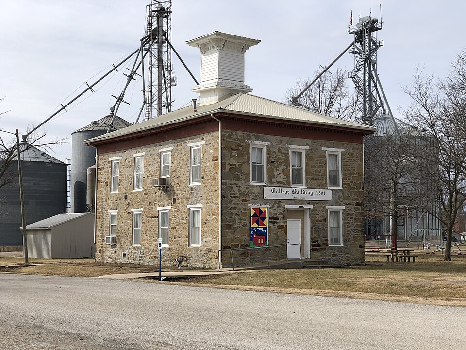
Listed on the National Register of Historic Places in 1972.
One of 21 National Register listings published here for Lyon County · listed in 1972 · category: Building.
Sources: the National Register database, National Park Service
Regional context, not property-specific evidence. The federal wildfire occurrence database lists 181 fires within 5 miles of Hartford Collegiate Institute between 1992 and 2020, burning about 12,120 acres in total. 1 started naturally. 21 were recorded as arson. Distance is straight-line from the map coordinates, so a fire counted here may appear on a neighbouring settlement's page as well.
| Reported cause | Fires |
|---|---|
| Debris and open burning | 99 |
| Missing data/not specified/undetermined | 42 |
| Arson/incendiarism | 21 |
| Smoking | 10 |
| Recreation and ceremony | 5 |
| Equipment and vehicle use | 3 |
| Natural | 1 |
The most recent of them, most recent first, with the day each was reported and the service that recorded it.
| Date | Cause | Size | Reported by | Name on the report |
|---|---|---|---|---|
| 1 September 1997 | Smoking | under an acre | Flint Hills National Wildlife Refuge | K130CIG |
| 30 August 1993 | Arson/incendiarism | 12 acres | Flint Hills National Wildlife Refuge | GILLIGAN |
| 17 August 1994 | Missing data/not specified/undetermined | 30 acres | Flint Hills National Wildlife Refuge | COONHAMMAN |
| 3 July 1992 | Debris and open burning | 3.0 acres | Flint Hills National Wildlife Refuge | STUBLE |
| 17 July 1995 | Debris and open burning | 7.0 acres | Flint Hills National Wildlife Refuge | PATSFIRE |
| 11 July 2003 | Missing data/not specified/undetermined | under an acre | Flint Hills National Wildlife Refuge | ATHERLY HILL WF 2003 |
| 1 July 1997 | Debris and open burning | 45 acres | Flint Hills National Wildlife Refuge | WILSON |
| 29 June 2006 | Arson/incendiarism | 3.0 acres | Flint Hills National Wildlife Refuge | SLAYMAKER |
Regional context, not property-specific evidence. The federal mineral resources record lists 1 working within 5 miles of Hartford Collegiate Institute: 1 producer. All of them still produce. What was taken out: Stone, Crushed/Broken. Distance is straight-line from the map coordinates, so a quarry counted here may appear on a neighbouring settlement's page as well.
| Where | Site | Commodity | Status | Recorded |
|---|---|---|---|---|
| Jones Quarry | Stone, Crushed/Broken | Producer |
Regional context, not property-specific evidence. The National Weather Service names Hartford, the town this property stands in, in 23 storm reports between 1999 and 2023: 10 thunderstorm wind, 6 hail, 4 flash flood, 2 tornado. No death or injury is recorded in these reports. Each account below is quoted exactly as the forecast office filed it, from the NOAA Storm Events Database, and each date opens the federal record of that event.
| When | Event | Place named | Harm | What the report says |
|---|---|---|---|---|
| November 2005 | Tornado (F0) | Hartford | $20,000 | The tornado touched down 3 miles SW of Hartford and moved nroth to 1.5 miles west of Hartford. The tornado produced F0 damage to buildings on three farmsteads and several other outbuildings along its path. The parent thunderstorm was a mini-supercell within a bow echo. |
| July 2023 | Thunderstorm Wind | Hartford | - | Personal weather station measured a gust of 67 mph. |
| June 2022 | Flash Flood | Hartford | - | Report of water flowing over the road in places along Road 30. |
| June 2022 | Flash Flood | Hartford | - | The media reported 3 to 4 feet of water over the roadway. |
| August 2019 | Thunderstorm Wind | Hartford | - | Estimated winds to around 70 mph. |
| May 2018 | Tornado (EF0) | Hartford | - | A photo of a possible brief tornado was received from radio media. No damage occurred. Time estimated. |
| August 2016 | Hail | Hartford | - | Report was relayed from KVOE. |
| July 2015 | Thunderstorm Wind | Hartford | - | Tree was uprooted and damage to a farmstead including broken windows. |
| July 2015 | Thunderstorm Wind | Hartford | - | Trees and power pole down at the intersection of road 80 and road V. |
| April 2010 | Flash Flood | Hartford | - | A road was washed out .5 mile north of Road 110 just outside Hartford. Spotter reported road under water well into Coffee County as well. |
| June 2009 | Thunderstorm Wind | Hartford | - | Large branches were broken off, and deck chairs were blown off the porch. |
| June 2009 | Thunderstorm Wind | Hartford | - | The city has lost power. |
| August 2008 | Thunderstorm Wind | Hartford | - | Three foot diameter trees were uprooted, and several one foot diameter tree limbs were blown down. |
| July 2008 | Funnel Cloud | Hartford | - | County dispatch relayed several public reports of two funnel clouds in close vicinity to one another in the southwest corner of Lyon County. |
| June 2008 | Thunderstorm Wind | Hartford | - | Several tree limbs, the largest twelve inches in diameter, were reported down around the town of Hartford. |
| June 2008 | Flash Flood | Hartford | - | Nearly every road in town was flooded. |
| August 2006 | Thunderstorm Wind | Hartford | - | Several 3 to 4 inch diameter tree limbs reported down. |
| June 2009 | Hail | Hartford | - | no account filed |
| June 2008 | Hail | Hartford | - | no account filed |
| November 2005 | Hail | Hartford | - | no account filed |
| April 2003 | Hail | Hartford | - | no account filed |
| May 2002 | Hail | Hartford | - | no account filed |
| May 1999 | Thunderstorm Wind | Hartford | - | no account filed |
No historic map-sheet match is published for this property yet. That does not mean no map exists. This record needs a coordinate-quality review before it can be joined to a sheet boundary. Browse the county's mapped places while that work is pending.
| National Archives record | The nomination case file for reference 72000512 in Record Group 79. |
| Lyon County | All 21 listed properties in this county. |