BlockBefore
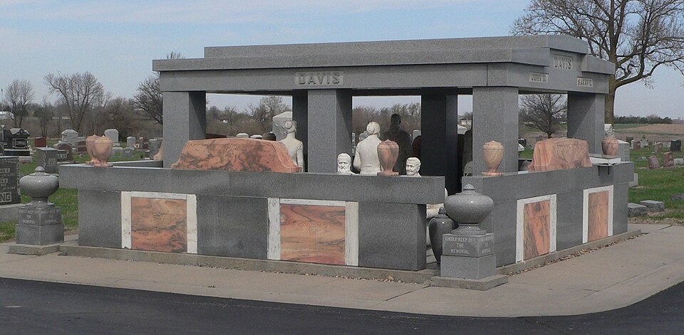
Photograph of Davis Memorial
Photograph by Ammodramus, CC0 1.0. Via Wikimedia Commons.

Davis Memorial

Built in 1931. Listed on the National Register of Historic Places in 1977.

From the record

“The Davis Memorial is a monument in Hiawatha, Kansas at the Mount Hope Cemetery, built by John Milburn Davis in honor of his wife Sarah after her death. Begun soon after her death in 1930 and completed in 1934, the monument consists of statues of the couple and a small shelter, carved from Italian marble.”

Wikipedia article Davis Memorial, CC BY-SA 4.0.

One of 17 National Register listings published here for Brown County · listed in 1977 · category: Object · built in 1931.

Sources: the Wikipedia article · the National Register database, National Park Service

The listing

  • What is counted as historic. The nomination lists 1 structure as contributing to the listing.
  • Address. 0.1 mi. E of Hiawatha, Mt. Hope Cemetery, Hiawatha, 66434
  • When was it listed? August 1977
  • Category. object
  • Township. Hiawatha township
  • When was it built? 1931
  • National Register reference number. 77000571 - assigned by the National Park Service when the property was listed.

Fires near this property

23 since 2015

Regional context, not property-specific evidence. The federal wildfire occurrence database lists 23 fires within 5 miles of Davis Memorial between 2015 and 2018, burning about 92 acres in total. None started naturally. None was recorded as arson. Distance is straight-line from the map coordinates, so a fire counted here may appear on a neighbouring settlement's page as well.

Reported cause Fires
Missing data/not specified/undetermined16
Debris and open burning4
Equipment and vehicle use2
Smoking1

The most recent of them, most recent first, with the day each was reported and the service that recorded it.

DateCause SizeReported by Name on the report
21 July 2015Missing data/not specified/undeterminedunder an acreKansas Forest Service78
23 April 2017Missing data/not specified/undeterminedunder an acreBrown County50
9 March 2017Missing data/not specified/undeterminedunder an acreBrown County31
7 March 2015Smokingunder an acreKansas Forest Service1500026
7 March 2015Missing data/not specified/undetermined5.0 acresKansas Forest Service24
6 March 2015Missing data/not specified/undeterminedunder an acreKansas Forest Service23
31 March 2015Debris and open burning5.0 acresKansas Forest Service39
25 March 2018Missing data/not specified/undeterminedunder an acreKansas Forest Service24

Every fire recorded in Brown County

Storms near this property

60 of 95 shown

Regional context, not property-specific evidence. The National Weather Service names Hiawatha, the town this property stands in, in 95 storm reports between 1995 and 2023: 42 hail, 34 thunderstorm wind, 12 flash flood, 3 lightning. No death or injury is recorded in these reports. Each account below is quoted exactly as the forecast office filed it, from the NOAA Storm Events Database, and each date opens the federal record of that event.

WhenEvent Place namedHarm What the report says
May 2007Flash FloodHiawatha$2,000,000Hiawatha had report of flooding of city streets. One resident has house flooded out and is being evacuated by city workers. Unofficial reports of 6 to 8 inches of rain with a few rural roads damaged by flash flooding. Flash flooding also severely damaged a low water impoundment dam on the Kickapoo Indian Reservation that is vital to their water supply. Total damage to the dam was estimated at 1.5 million dollars.
June 2005Tornado (F2)Hiawatha$400,000Three farmsteads or businesses sustained damage with a total of 15 buildings damaged or destroyed. Several cars were rolled and a combine was moved a considerable distance. A salvage yard was near one of the houses damaged by the tornado. A hubcap from the salvage yard had become airborne and was impaled in the sheet rock in the living room of the house.
July 1997HailHiawatha$100,000no account filed
June 2010Thunderstorm WindHiawatha$20,000Trained spotters reported 70 to 80 mph winds across Brown County. Power lines were down in Everest and Robinson. Trees were snapped throughout the county, and in Robinson a grain elevator was heavily damaged.
August 2003Thunderstorm WindHiawatha$5,000Strong winds damaged a barn south of Hiawatha.
June 1998Thunderstorm WindHiawatha$5,000no account filed
June 1998Thunderstorm WindHiawatha$4,000no account filed
April 2001Thunderstorm WindHiawatha$3,000Strong winds damaged roofs.
June 2000Thunderstorm WindHiawatha$3,000Strong winds downed tree limbs and damaged power lines.
July 2000Thunderstorm WindHiawatha$3,000Strong winds damaged a barn south of Hiawatha.
June 1998Thunderstorm WindHiawatha$3,000no account filed
May 2007LightningHiawatha$1,000An official from a local energy company said more than 3,500 customers were left without power after thunderstorms rolled across Hiawatha. Lightning hitting a power line was stated to be the cause of the outage.
May 2005Flash FloodHiawatha$500Numerous reports of fast flowing water over numerous streets and roads including Highway 75 and 36 as well as prairie road.
June 2023Thunderstorm WindHiawatha-Wind gusts estimated at 60 mph.
June 2021Thunderstorm WindHiawatha-Trees down in the city of Hiawatha.
June 2018Thunderstorm WindHiawatha-Trees blown over with numerous tree limbs down in Hiawatha.
June 2017Thunderstorm WindHiawatha-Estimated winds 60-65 MPH. Numerous tree limbs down, some 2.5 to 3 inches in diameter. Minor street flooding was also reported.
June 2017Thunderstorm WindHiawatha-Numerous 3 inch, or larger diameter limbs were reported down.
June 2014Thunderstorm WindHiawatha-Power was out due to the winds.
June 2014Thunderstorm WindHiawatha-Small tree limbs were blown down.
June 2014Thunderstorm WindHiawatha-Wind gusts were estimated.
May 2014Thunderstorm WindHiawatha-Wind caused a roof to lift up and shift an outbuilding. Also half inch hail was falling.
September 2013Thunderstorm WindHiawatha-Several power poles and one tree reported blown down in the city of Hiawatha.
August 2012Thunderstorm WindHiawatha-A tree and some powerlines were reported down in Hiawatha.
June 2009Funnel CloudHiawatha-A spotter reported a funnel cloud two miles northwest of Hiawatha, Kansas.
May 2009Flash FloodHiawatha-A small stream swelled beyond it's banks and spilled over Hwy 73 north and east of Hiawatha. The highway was briefly closed because of flowing water over the roadway. Further north, Krestel Road, south of the town of Reserve, was also closed because of flowing water over the roadway.
June 2009Thunderstorm WindHiawatha-Tree down in Hiawatha.
May 2008HailHiawatha-Wind gust speed around 40 miles per hour also reported.
October 2007Flash FloodHiawatha-Four to six inches of water reported to be over roadways in Hiawatha. There were also two reports of heavy rainfall in Brown county. One report of 3.70 inches was received 3 miles WNW of Hiawatha, and one report was received in the town of Powhattan.
August 2007Flash FloodHiawatha-Running water 7 inches deep on both HWY 73 and Oregon Street within the city limits of Hiawatha.
March 2006Thunderstorm WindHiawatha-Numerous telephone poles down, trailer blown off foundation, grain bins blown up against houses, trees down.
August 2006Thunderstorm WindHiawatha-Large tree branches down in the city.
August 2006HailHiawatha-Pea to nickel sized hail.
June 2002Flash FloodHiawatha-Heavy rains from thunderstorms in the Hiawatha to Horton areas caused flash flooding with water over some roadways.
July 2001Flash FloodHiawatha-Heavy rains produced flash flooding. Many roads were flooded with some barracaded for a time.
June 2001Flash FloodHiawatha-Heavy rains produced flash flooding and caused some roads to be covered by water for a time.
September 2001Flash FloodHiawatha-Runoff from heavy rains flooded some roads near Hiawatha.
April 1999Tornado (F0)Hiawatha-The storm that earlier produced a tornado near Fairview moved northeast and spawned another touchdown north of Hiawatha.
May 2019HailHiawatha-no account filed
August 2019HailHiawatha-no account filed
May 2015HailHiawatha-no account filed
April 2014HailHiawatha-no account filed
June 2014HailHiawatha-no account filed
May 2014HailHiawatha-no account filed
April 2013HailHiawatha-no account filed
April 2010HailHiawatha-no account filed
March 2009HailHiawatha-no account filed
June 2008HailHiawatha-no account filed
April 2006HailHiawatha-no account filed
June 2006HailHiawatha-no account filed
July 2006Thunderstorm WindHiawatha-no account filed
June 2005HailHiawatha-no account filed

Every storm recorded in Brown County

Map coverage status

No historic map-sheet match is published for this property yet. That does not mean no map exists. This record needs a coordinate-quality review before it can be joined to a sheet boundary. Browse the county's mapped places while that work is pending.

Listed places nearby

6 within 8 miles

Other National Register properties close enough to walk or drive between, ordered by distance from this one. Both positions come from the same geocoding pass that matched these properties to their map sheets.

Photograph PropertyDistance Listed
Hiawatha National Guard Armory0.7 miles2004
Hiawatha Memorial Auditorium1.1 miles1985
Hiawatha Courthouse Square Historic District1.2 miles2006
William and Augusta Guild House1.2 miles2024
Samuel Bierer House1.3 miles2010
Bethany Brethren Church7.6 miles2012

Sources for this property

National Archives recordThe nomination case file for reference 77000571 in Record Group 79.
Wikipedia articleCommunity-written account of this property, licensed CC BY-SA.
Brown CountyAll 17 listed properties in this county.

Provenance

  • Listing record. National Park Service National Register of Historic Places, listed-properties dataset, current to 2026-05-22.
  • Map join. Address geocoded through the United States Census geocoder, then tested against the published boundary of every sheet in the USGS Historical Topographic Map Collection.
  • How this page is made. Listing fields come from federal records; map-sheet coverage is a labelled coordinate-to-boundary calculation, not a source-field claim.
  • Wildfire. Short, Karen C. 2022. Spatial wildfire occurrence data for the United States, 1992-2020 [FPA_FOD_20221014]. 6th Edition. Fort Collins, CO: Forest Service Research Data Archive. https://doi.org/10.2737/RDS-2013-0009.6 Collected with United States Government funding and usable without additional permissions or fees.
  • Storms. NOAA National Centers for Environmental Information, Storm Events Database https://www.ncei.noaa.gov/stormevents/ A work of the United States government, no copyright under 17 U.S.C. 105. Narratives are quoted verbatim from the National Weather Service report and are not edited or summarised.