 Block
From the record
One of 9 National Register listings published here for Neosho County · listed in 1977 · category: Structure.
Sources: the National Register database, National Park Service
Listed on the National Register of Historic Places in 1977.
One of 9 National Register listings published here for Neosho County · listed in 1977 · category: Structure.
Sources: the National Register database, National Park Service
Regional context, not property-specific evidence. The federal wildfire occurrence database lists 60 fires within 5 miles of Austin Bridge between 2015 and 2020, burning about 685 acres in total. None started naturally. 1 was recorded as arson. Distance is straight-line from the map coordinates, so a fire counted here may appear on a neighbouring settlement's page as well.
| Reported cause | Fires |
|---|---|
| Debris and open burning | 26 |
| Missing data/not specified/undetermined | 22 |
| Equipment and vehicle use | 4 |
| Smoking | 4 |
| Recreation and ceremony | 1 |
| Arson/incendiarism | 1 |
| Fireworks | 1 |
| Misuse of fire by a minor | 1 |
The most recent of them, most recent first, with the day each was reported and the service that recorded it.
| Date | Cause | Size | Reported by | Name on the report |
|---|---|---|---|---|
| 14 September 2017 | Missing data/not specified/undetermined | under an acre | Neosho County | 872 |
| 22 August 2015 | Fireworks | under an acre | Kansas Forest Service | 712 |
| 1 August 2018 | Missing data/not specified/undetermined | 1.0 acres | Kansas Forest Service | 782 |
| 24 July 2015 | Equipment and vehicle use | under an acre | Kansas Forest Service | 623 |
| 18 July 2017 | Missing data/not specified/undetermined | under an acre | Neosho County | 676 |
| 13 July 2018 | Equipment and vehicle use | 2.0 acres | Kansas Forest Service | 2018020 |
| 24 June 2017 | Missing data/not specified/undetermined | under an acre | Neosho County | 581 |
| 9 May 2018 | Missing data/not specified/undetermined | under an acre | Kansas Forest Service | 2018015 |
Regional context, not property-specific evidence. The federal mineral resources record lists 1 working within 5 miles of Austin Bridge: 1 producer. All of them still produce. What was taken out: Stone, Crushed/Broken. Distance is straight-line from the map coordinates, so a quarry counted here may appear on a neighbouring settlement's page as well.
| Where | Site | Commodity | Status | Recorded |
|---|---|---|---|---|
| Chanute Cement Quarry & Plant | Stone, Crushed/Broken | Producer |
Regional context, not property-specific evidence. The National Weather Service names Chanute, the town this property stands in, in 126 storm reports between 1993 and 2026: 52 thunderstorm wind, 46 hail, 11 flash flood, 9 flood. No death or injury is recorded in these reports. Each account below is quoted exactly as the forecast office filed it, from the NOAA Storm Events Database, and each date opens the federal record of that event.
| When | Event | Place named | Harm | What the report says |
|---|---|---|---|---|
| July 2007 | Flash Flood | Chanute | $12,000,000 | Extremely heavy rainfall from the end of June into early July caused flash flooding throughout Neosho County. The flash flooding and the ensuing river flooding resulted in roughly 100 homes being destroyed and another 50 sustaining major damage. This resulted in at least 10.5 million dollars in damages. An additional 1.5 million dollars in damage was reported public infrastructure. The Neosho River reached a record crest of 40.6 feet on the morning of July 2nd. This was 11.6 feet above flood stage. Major flooding was seen on the Neosho at Chanute when a crest of 36.82 feet was recorded on the morning of July 1st. The Neosho inundated the city of Chanute with some areas under as much as 7 to 8 feet of water. The river remained above flood stage at Chanute until July 4th and at Erie until July 5th. |
| June 2005 | Thunderstorm Wind | Chanute | $1,000,000 | Extensive damage! Large trees uprooted, with many falling onto homes and businesses. Roofs literally blown off many homes and businesses. Numerous barns and sheds destroyed. All of town without power. |
| September 2012 | Thunderstorm Wind | Chanute | $265,100 | Four travel trailers and eight vehicles were damaged or destroyed. One such trailer was 28 feet long and attached to a Ford F250, both of which were blown over. A couple of old barns and tin buildings were also destroyed. Downed trees and power lines were reported in Chanute. |
| April 2009 | Flood | Chanute | $200,000 | Continued runoff from a couple heavy rainfall episodes from the 26th through the 30th produced river flooding along the Neosho River, and its associated tributaries across Neosho county. Several rural and some city roads were closed due to high water. The river flooding along the Neosho extended into the early mornings hours of May 2nd. Property damage amounts are rough estimates. The Chanute Tribune contributed to this report. |
| April 2023 | Thunderstorm Wind | Chanute | $100,000 | Considerable reports of tree damage across Chanute with some roof damage and damage to numerous buildings. |
| April 2023 | Thunderstorm Wind | Chanute | $100,000 | Several large trees were uprooted with roof damage to numerous buildings in Chanute. Winds were estimated around 80 mph. |
| May 2000 | Thunderstorm Wind | Chanute | $100,000 | Two large trees uprooted. The trees' roots, possessing a span of about 7 feet, lifted one side of a house from it's foundation, forcing the bathroom into the kitchen where the bathtub was found standing at a 45 degree angle! Both trees toppled onto a next-door neighbor's house causing damage to it's roof. |
| June 1998 | Thunderstorm Wind | Chanute | $90,000 | Trees and power lines downed. |
| February 2000 | Thunderstorm Wind | Chanute | $75,000 | A storage building under construction collapsed. |
| June 2007 | Flash Flood | Chanute | $70,000 | Numerous roads were closed due to water flowing across them in the northeast portion of the county including Piatt Road near Odense and US Highway 59 west of Stark. |
| May 2019 | Flash Flood | Chanute | $50,000 | Numerous roads were reported underwater across Chanute with multiple cars stalled cars and people needed rescue. Water was reported over Highway 39 at the intersection with US Highway 169. |
| May 2019 | Flash Flood | Chanute | $50,000 | Several homes had to be evacuated across the town of Chanute due to high water. Approximately 10 to 15 people were affected. Rainfall totals were 5 to 6 inches in a short period of time. |
| April 1993 | Hail | Chanute | $50,000 | From 2100 CST and 2305 CST a thunderstorm dropped hail as large as two inches in diameter in Chanute and across a good share of northern Neosho County. The hail covered the ground in Chanute and north of Erie accumulating to several inches in depth west of Shaw. The storm hit with greatest force around Chanute, especially near Earlton and Shaw, where more thn 200 vehicles were damaged. |
| April 1993 | Hail | Chanute | $50,000 | no account filed |
| April 1993 | Hail | Chanute | $50,000 | no account filed |
| April 1993 | Hail | Chanute | $50,000 | no account filed |
| April 1993 | Hail | Chanute | $50,000 | no account filed |
| April 2003 | Thunderstorm Wind | Chanute | $35,000 | Roof blown off a storage building. At same location, top 40 feet of wireless tower destroyed. |
| June 2007 | Lightning | Chanute | $22,000 | Lightning struck a residence in the city of Chanute the evening of June 1st. The Chanute Tribune contributed to this report. |
| April 2023 | Thunderstorm Wind | Chanute | $20,000 | An apartment complex lost it garage due to strong winds. |
| May 2019 | Thunderstorm Wind | Chanute | $20,000 | Tree limbs were reported knocked down. |
| June 2008 | Thunderstorm Wind | Chanute | $18,000 | Several power lines and tree limbs were downed. |
| August 2023 | Flood | Chanute | $10,000 | Reports of low lying areas of the county flooded due to heavy rain. |
| August 2019 | Thunderstorm Wind | Chanute | $10,000 | A billboard sign was blown over along highway 39 east of Chanute. |
| June 2017 | Thunderstorm Wind | Chanute | $10,000 | Trees and power poles were blown down across town. The report was received at 320 AM CDT/220 AM CST. |
| August 2003 | Thunderstorm Wind | Chanute | $10,000 | Garage at one residence damaged when uprooted maple tree fell onto it. (Chanute Tribune). |
| August 2020 | Thunderstorm Wind | Chanute | $8,000 | Power lines were knocked down. |
| May 2004 | Lightning | Chanute | $5,000 | Van struck in parking lot of Chanute SRS Office. Concussion of resultant thunderclap of sufficient magnitude to shatter 10 large windows and an unspecified number of smaller windows. The lightning strike also produced two craters in the pavement beneath the vehicle's right tires, the right rear tire being deflated. (Report and narrative courtesy of Chanute Tribune.) |
| July 2004 | Thunderstorm Wind | Chanute | $5,000 | Downed power lines. Speed estimated per 0357 CST report from 3N Erie. |
| July 1994 | Thunderstorm Wind | Chanute | $5,000 | Extensive tree damage occurred. |
| April 1993 | Hail | Chanute | $5,000 | no account filed |
| November 2012 | Thunderstorm Wind | Chanute | $3,000 | A metal shed was blown over. |
| July 2006 | Thunderstorm Wind | Chanute | $3,000 | A utility pole was downed near the intersection of 230th Road and Brown Road. |
| August 2020 | Thunderstorm Wind | Chanute | $1,000 | Six inch diameter tree limbs were down. |
| July 2011 | Thunderstorm Wind | Chanute | $500 | Tree limbs were downed. |
| August 2019 | Flash Flood | Chanute | $100 | Various low water crossing were flooded in Chanute. |
| October 2018 | Flood | Chanute | $100 | A larger amount of water wad reported over the road at 210th and Lyons Road near the Big Creek. |
| July 2010 | Flash Flood | Chanute | $100 | Numerous county roads and roads across the town of Chanute had water over them. |
| March 2026 | Thunderstorm Wind | Chanute | - | Wind gusts were estimated to be around 60 mph. |
| April 2024 | Flood | Chanute | - | Heavy rainfall from training thunderstorms led to rises along rivers, creeks and streams. Observer measured 7.37 inches of rain in the last 24 hours in Erie; another rainfall report at the Chanute Martin Johnson Airport was 6.71 inches over the same timeframe. This resulted in flooding of multiple roads in the county and moderate flooding along the Neosho River at both Erie and Chanute. Some parts of the levee system broke near the Erie gage site and a few miles upstream. The impacts were flooding in fields, agricultural areas and some streets in Erie. |
| June 2024 | Thunderstorm Wind | Chanute | - | Roof damage to a home was relayed with a picture. The report indicated tree damage occurred as well. |
| July 2023 | Thunderstorm Wind | Chanute | - | A Facebook picture showed 6 to 8-inch tree limbs down. |
| August 2023 | Flood | Chanute | - | There was am underpass flooded in Chanute. Barricades were put up as a result. |
| August 2023 | Thunderstorm Wind | Chanute | - | Chanute airport reported a measured thunderstorm wind gust. |
| March 2021 | Flood | Chanute | - | Flooding of low lying areas occurred across the county with a few roads being closed. |
| May 2021 | Heavy Rain | Chanute | - | This is a 24 hour rainfall report of 3.69 inches. |
| July 2021 | Heavy Rain | Chanute | - | This was a 24 hour rain total of 5.21 inches. |
| July 2021 | Heavy Rain | Chanute | - | This was a 24 hour rain total of 5.0 inches. |
| July 2021 | Heavy Rain | Chanute | - | This was a 24 hour rain total of 7.52 inches. |
| August 2020 | Thunderstorm Wind | Chanute | - | A trained spotter relayed the wind gust. |
| June 2019 | Thunderstorm Wind | Chanute | - | Large trees were blown down. |
| May 2019 | Flash Flood | Chanute | - | Flash flooding closed Highway 39 just east of Chanute. |
| August 2019 | Thunderstorm Wind | Chanute | - | Tree branches were reported down on the east side of Chanute, near 9th and Ashby. |
| August 2019 | Flash Flood | Chanute | - | Santa Fe road near 16th street was underwater and not passable. |
| August 2019 | Thunderstorm Wind | Chanute | - | The estimated speeds ranged from 50 to 60 mph. |
| May 2018 | Hail | Chanute | - | The hail lasted a full 10 minutes. |
| June 2018 | Thunderstorm Wind | Chanute | - | Measured by official observing equipment. |
| February 2017 | Hail | Chanute | - | The report was received via Twitter. The hail partially covered the ground at the 9th & Evergreen Intersection. The time of the event was adjusted by radar. |
| February 2017 | Hail | Chanute | - | The report was received from The Chanute Tribune. |
| February 2017 | Hail | Chanute | - | The report was received via Twitter, but there were no reports of damage. |
No historic map-sheet match is published for this property yet. That does not mean no map exists. This record needs a coordinate-quality review before it can be joined to a sheet boundary. Browse the county's mapped places while that work is pending.
Other National Register properties close enough to walk or drive between, ordered by distance from this one. Both positions come from the same geocoding pass that matched these properties to their map sheets.
| Photograph | Property | Distance | Listed |
|---|---|---|---|
| Murray Hill School | 1.7 miles | 2011 | |
 | Tioga Inn | 1.8 miles | 1990 |
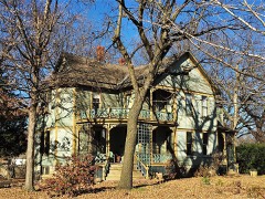 | James and Ella Truitt House | 1.9 miles |
| National Archives record | The nomination case file for reference 77000592 in Record Group 79. |
| Neosho County | All 9 listed properties in this county. |