 Block
From the record
9 National Register listings published here.
Sources: the National Register database, National Park Service
55 topographic sheets cover 15 settlements here, and 9 properties are on the National Register of Historic Places.
9 National Register listings published here.
Sources: the National Register database, National Park Service
Every property in this county listed on the National Register of Historic Places, with the year it was listed and the federal nomination document.
| Photograph | Property | Type | Listed | Reference |
|---|---|---|---|---|
| Austin Bridge | structure | 1977 | 77000592 | |
| First Christian Church | building | 2021 | 100007025 | |
| Maxwell's Slough Bridge | structure | 1985 | 85001429 | |
| Murray Hill School | building | 2011 | 11000580 | |
| Oak Grove School, District 20 | building | 2016 | 16000405 | |
| Osage Mission Infirmary | building | 2005 | 05000976 | |
| State Steet Bridge | structure | 1985 | 85001441 | |
 | Tioga Inn | building | 1990 | 90000150 |
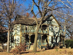 | James and Ella Truitt House | building | 14000117 |
Every wildfire the federal occurrence database records inside this county: 198 of them, burning about 5,370 acres. 2 started naturally and 16 were recorded as arson. Each settlement page carries the fires within five miles of it.
| Reported cause | Fires |
|---|---|
| Debris and open burning | 77 |
| Missing data/not specified/undetermined | 61 |
| Smoking | 19 |
| Arson/incendiarism | 16 |
| Equipment and vehicle use | 16 |
| Recreation and ceremony | 3 |
| Natural | 2 |
| Other causes | 1 |
| Power generation/transmission/distribution | 1 |
| Fireworks | 1 |
| Misuse of fire by a minor | 1 |
The five largest, by the area the report gives. Two of them were set deliberately.
| Date | Cause | Size | Reported by | Name on the report |
|---|---|---|---|---|
| 23 August 2012 | Missing data/not specified/undetermined | 2,560 acres | Kansas Counties | ALABAMA ROAD |
| 28 January 2015 | Smoking | 250 acres | Kansas Forest Service | 97 |
| 7 March 2015 | Smoking | 200 acres | Kansas Forest Service | 150307A |
| 11 March 2015 | Missing data/not specified/undetermined | 200 acres | Kansas Forest Service | 150311 |
| 22 March 2015 | Smoking | 120 acres | Kansas Forest Service | 150322 |
| 12 February 2017 | Arson/incendiarism | 100 acres | Neosho County | 17007 |
| 28 February 2017 | Arson/incendiarism | 80 acres | Neosho County | 17012 |
| 14 February 2015 | Debris and open burning | 80 acres | Kansas Forest Service | 12 |
Every settlement page carries the fires within five miles of it - see the settlement index below.
The NOAA Storm Events Database holds 540 reports for this county, causing no deaths, 4 injuries and about $22,111,200 in recorded property damage. Each settlement page carries the reports that name it.
| Kind of event | Reports |
|---|---|
| Thunderstorm Wind | 244 |
| Hail | 188 |
| Tornado | 29 |
| Heavy Rain | 29 |
| Flash Flood | 24 |
| Flood | 23 |
| Lightning | 3 |
The most serious of them, by death, then injury, then recorded damage. The accounts are quoted exactly as the forecast office filed them.
| When | Event | Place named | Harm | What the report says |
|---|---|---|---|---|
| April 2000 | Tornado (F2) | Erie | 3 hurt, $1,800,000 | Forming at 1920 CST 6 miles southwest of Erie, the tornado moved northeast around 35 mph passing just south of Erie at 1931 CST. F2 intensity for much of it's track, the tornado injured 3 people on the southern periphery of Erie as it destroyed or heavily damaged 12 homes, several mobile homes, as well as a few trees. This tornado then crossed into Crawford county. |
| March 1973 | Tornado (F2) | not stated | 1 hurt, $250,000 | no account filed |
| July 2007 | Flash Flood | Chanute | $12,000,000 | Extremely heavy rainfall from the end of June into early July caused flash flooding throughout Neosho County. The flash flooding and the ensuing river flooding resulted in roughly 100 homes being destroyed and another 50 sustaining major damage. This resulted in at least 10.5 million dollars in damages. An additional 1.5 million dollars in damage was reported public infrastructure. The Neosho River reached a record crest of 40.6 feet on the morning of July 2nd. This was 11.6 feet above flood stage. Major flooding was seen on the Neosho at Chanute when a crest of 36.82 feet was recorded on the morning of July 1st. The Neosho inundated the city of Chanute with some areas under as much as 7 to 8 feet of water. The river remained above flood stage at Chanute until July 4th and at Erie until July 5th. |
| June 2005 | Thunderstorm Wind | Chanute | $1,000,000 | Extensive damage! Large trees uprooted, with many falling onto homes and businesses. Roofs literally blown off many homes and businesses. Numerous barns and sheds destroyed. All of town without power. |
| June 1998 | Thunderstorm Wind | Erie | $1,000,000 | Two stores unroofed andtwo mobile homes heavily damaged. Numerous trees and power lines downed. |
| June 2005 | Thunderstorm Wind | Erie | $500,000 | Extensive damage! Numerous large trees uprooted, with some falling onto homes. One home reportedly destroyed 0.5 mile north of Erie. Many homes unroofed with numerous barns and sheds destroyed. All of town without power. |
| June 2005 | Thunderstorm Wind | St Paul | $500,000 | Extensive damage! Numerous large trees uprooted with many falling onto homes. Many homes unroofed, with numerous barns and sheds destroyed. All of town without power. |
| April 1993 | Hail | Shaw | $500,000 | no account filed |
| June 2005 | Thunderstorm Wind | St Paul | $400,000 | Tall church steeple removed. Large trees uprooted, downed power lines and power poles, as well as other unspecified structural damage. (Arkansas City Traveler contributed to this narrative.) |
| September 2012 | Thunderstorm Wind | Chanute | $265,100 | Four travel trailers and eight vehicles were damaged or destroyed. One such trailer was 28 feet long and attached to a Ford F250, both of which were blown over. A couple of old barns and tin buildings were also destroyed. Downed trees and power lines were reported in Chanute. |
| August 1998 | Hail | Galesburg | $250,000 | Tennisball to softball-sized hail pelted a one square mile section on the south side of Lake Parsons, inflicting extensive damage to boats, tents, campers, vehicles, buildings and crops. |
| June 1983 | Tornado (F1) | not stated | $250,000 | no account filed |
| May 1982 | Tornado (F1) | not stated | $250,000 | no account filed |
| May 1973 | Tornado (F2) | not stated | $250,000 | no account filed |
| March 1973 | Tornado (F2) | not stated | $250,000 | no account filed |
| April 2009 | Flood | Chanute | $200,000 | Continued runoff from a couple heavy rainfall episodes from the 26th through the 30th produced river flooding along the Neosho River, and its associated tributaries across Neosho county. Several rural and some city roads were closed due to high water. The river flooding along the Neosho extended into the early mornings hours of May 2nd. Property damage amounts are rough estimates. The Chanute Tribune contributed to this report. |
| April 2005 | Tornado (F3) | Galesburg | $200,000 | Damage summary: Two miles south of Galesburg: One barn damaged & two out-buildings destroyed. Three miles southeast of Galesburg: Two mobile homes destroyed, one frame house dislodged from it's foundation & two barns destroyed. Four miles east-southeast of Galesburg: Frame house unroofed with two exterior walls collapsed. A garage and one shed were destroyed. Tree damage occurred at each of these locations. |
| November 2005 | Tornado (F1) | Erie | $120,000 | Shortly after touchdown approximately 2 miles northeast of Erie, the tornado produced F1 damage to homes, outbuildings and trees. Thereafter, the tornado lost some of its intensity, and subsequent damage was rated F0. |
| May 2009 | Thunderstorm Wind | Thayer | $110,000 | The towns of Thayer and Galesburg were hit hard by damaging winds estimated at 70 mph. Numerous large trees were blown down across both towns, with some falling on houses and outbuildings. A few businesses in Thayer had portions of their roofs blown off. A few mobile homes in rural areas were rolled over with grains bins lifted off their foundations and thrown into the road. |
| April 2023 | Thunderstorm Wind | Chanute | $100,000 | Considerable reports of tree damage across Chanute with some roof damage and damage to numerous buildings. |
| April 2023 | Thunderstorm Wind | Chanute | $100,000 | Several large trees were uprooted with roof damage to numerous buildings in Chanute. Winds were estimated around 80 mph. |
| August 2009 | Thunderstorm Wind | Earlton | $100,000 | Thunderstorm winds up to 65 mph affected areas between roughly Earlton and St. Paul, including the community of Erie, during the late evening hours on the 19th. Corn stalks just east of Earlton were pushed over some, but likely still salvageable. Hay bales were blown around, and a few trees were downed. Additionally, about 3 miles south of Chanute on Elk Road, a wellhouse roof was ripped off and tree limbs were downed. Numerous trees were downed across the area. The Chanute Tribune and Erie Record contributed to this report. |
| May 2000 | Thunderstorm Wind | Chanute | $100,000 | Two large trees uprooted. The trees' roots, possessing a span of about 7 feet, lifted one side of a house from it's foundation, forcing the bathroom into the kitchen where the bathtub was found standing at a 45 degree angle! Both trees toppled onto a next-door neighbor's house causing damage to it's roof. |
| June 1998 | Thunderstorm Wind | Chanute | $90,000 | Trees and power lines downed. |
| February 2000 | Thunderstorm Wind | Chanute | $75,000 | A storage building under construction collapsed. |
| June 2007 | Flash Flood | Chanute | $70,000 | Numerous roads were closed due to water flowing across them in the northeast portion of the county including Piatt Road near Odense and US Highway 59 west of Stark. |
| May 2019 | Flash Flood | Chanute | $50,000 | Numerous roads were reported underwater across Chanute with multiple cars stalled cars and people needed rescue. Water was reported over Highway 39 at the intersection with US Highway 169. |
| May 2019 | Flash Flood | Chanute | $50,000 | Several homes had to be evacuated across the town of Chanute due to high water. Approximately 10 to 15 people were affected. Rainfall totals were 5 to 6 inches in a short period of time. |
| August 2009 | Thunderstorm Wind | Thayer | $50,000 | Trees and power lines were downed throughout the community. A tree fell on a house, but no injuries were reported. |
| July 2003 | Thunderstorm Wind | Erie | $50,000 | Pole barn roof collapsed. Micro-burst suspected. |
| August 2003 | Thunderstorm Wind | St Paul | $50,000 | One residence extensively damaged when the east-facing garage door was ripped from it's supports causing the roof to collapse onto the three vehicles parked inside. A barn approximately 1 mile west of the property was unroofed with the dislodged roof and sections of tin scattered 1/4 mile across an adjacent field. (Chanute Tribune). |
| October 1998 | Thunderstorm Wind | St Paul | $50,000 | Vehicle was blown into front window of a building, numerous power poles blown down, and 3 buildings had roofs blown off. |
| June 1994 | Thunderstorm Wind | Erie | $50,000 | Strong thunderstorm winds lasting thirty minutes damaged roofs and trees in the north part of town. |
| April 1993 | Hail | Chanute | $50,000 | From 2100 CST and 2305 CST a thunderstorm dropped hail as large as two inches in diameter in Chanute and across a good share of northern Neosho County. The hail covered the ground in Chanute and north of Erie accumulating to several inches in depth west of Shaw. The storm hit with greatest force around Chanute, especially near Earlton and Shaw, where more thn 200 vehicles were damaged. |
| April 1993 | Hail | Chanute | $50,000 | no account filed |
| April 1993 | Hail | Chanute | $50,000 | no account filed |
| April 1993 | Hail | Chanute | $50,000 | no account filed |
| April 1993 | Hail | Chanute | $50,000 | no account filed |
| April 1993 | Hail | Earlton | $50,000 | no account filed |
| May 2011 | Thunderstorm Wind | St Paul | $40,000 | Winds estimated around 80 mph inflicted extensive damage to a farmstead. A pole-barn and outbuilding were flattened, several cars were damaged, the roof of their home was damaged, and a trailer was flipped over. The Chanute Tribune contributed to this report. |
| August 2006 | Thunderstorm Wind | Erie | $35,000 | The roof was blown off of the highland dairy cooler. |
| April 2003 | Thunderstorm Wind | Chanute | $35,000 | Roof blown off a storage building. At same location, top 40 feet of wireless tower destroyed. |
| August 2009 | Lightning | Earlton | $25,000 | Lightning reportedly struck a grain bin just east of Earlton. Consequently, a fire erupted, engulfing and eventually destroying the bin. No one was injured. Damage amounts are rough estimates. The Chanute Tribune contributed to this report. |
| June 2008 | Thunderstorm Wind | St Paul | $25,000 | An unsecured trailer house was blown over on its side. |
| June 2005 | Thunderstorm Wind | Erie | $25,000 | Downed large limbs, some of which fell onto homes. Carports blown over. Downed power lines and power poles. |
| August 2002 | Thunderstorm Wind | St Paul | $25,000 | Part of roof blown off old city hall. |
| April 2000 | Tornado (F0) | South Mound | $25,000 | The same tornado that caused major damage in Parsons, the twister clipped southeast Neosho County where it destroyed a hay barn and blew out the windows of a house. |
| August 1998 | Thunderstorm Wind | St Paul | $25,000 | Power poles and power lines blown down. |
| November 1988 | Tornado (F1) | not stated | $25,000 | no account filed |
| November 1988 | Tornado (F2) | not stated | $25,000 | no account filed |
| May 1973 | Tornado (F1) | not stated | $25,000 | no account filed |
| May 1954 | Tornado (F2) | not stated | $25,000 | no account filed |
| May 1954 | Tornado (F2) | not stated | $25,000 | no account filed |
| June 2007 | Lightning | Chanute | $22,000 | Lightning struck a residence in the city of Chanute the evening of June 1st. The Chanute Tribune contributed to this report. |
| April 2023 | Thunderstorm Wind | Chanute | $20,000 | An apartment complex lost it garage due to strong winds. |
| May 2019 | Thunderstorm Wind | Chanute | $20,000 | Tree limbs were reported knocked down. |
| June 2008 | Thunderstorm Wind | Erie | $20,000 | Several power lines and tree limbs were blown down. |
| June 2008 | Thunderstorm Wind | Chanute | $18,000 | Several power lines and tree limbs were downed. |
| June 1995 | Thunderstorm Wind | Erie | $16,000 | The roof was blown off of a store two blocks East of Highway 59. |
| July 1995 | Thunderstorm Wind | Erie | $16,000 | A mobile home was blown off of it's foundation. |
The Survey's mineral resources record lists 3 workings inside this county. All of them still produce. Each settlement page carries the workings within five miles of it.
| Commodity | Workings |
|---|---|
| Stone, Crushed/Broken | 2 |
| Sand and Gravel, Construction | 1 |
The least common of them first, because a county's hundredth gravel pit says nothing its first ten did not.
| Where | Site | Commodity | Status | Recorded |
|---|---|---|---|---|
| Hy-Grade Sand & Gravel Pit & Plant | Sand and Gravel, Construction | Producer | ||
| Chanute Cement Quarry & Plant | Stone, Crushed/Broken | Producer | ||
| Neosho County Portable Crusher | Stone, Crushed/Broken | Producer |
Named settlements recorded in the Geographic Names Information System, each with the topographic sheets covering it. Villages, hamlets and abandoned places alike. Each is shown with the nearest named watercourse or landform and the survey quadrangle it falls on.