 Block
From the record
One of 108 National Register listings published here for Shawnee County · listed in 1985 · category: Structure · built in 1915.
Sources: the National Register database, National Park Service
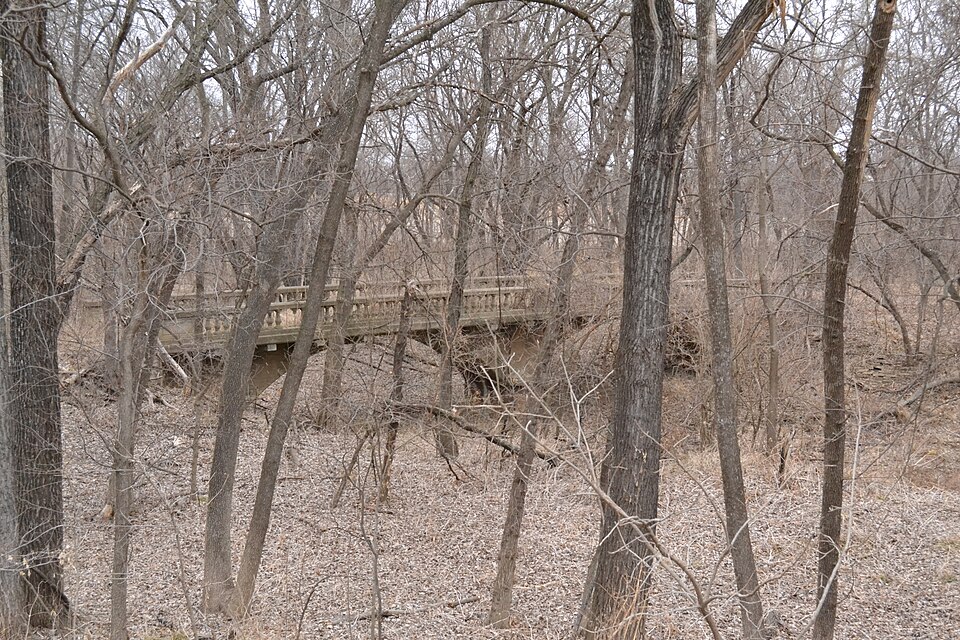
Built in 1915. Listed on the National Register of Historic Places in 1985.
One of 108 National Register listings published here for Shawnee County · listed in 1985 · category: Structure · built in 1915.
Sources: the National Register database, National Park Service
Regional context, not property-specific evidence. The federal wildfire occurrence database lists 154 fires within 5 miles of McCauley Bridge between 2015 and 2020, burning about 1,372 acres in total. 2 started naturally. 4 were recorded as arson. Distance is straight-line from the map coordinates, so a fire counted here may appear on a neighbouring settlement's page as well.
| Reported cause | Fires |
|---|---|
| Debris and open burning | 105 |
| Missing data/not specified/undetermined | 31 |
| Arson/incendiarism | 4 |
| Smoking | 4 |
| Recreation and ceremony | 3 |
| Equipment and vehicle use | 2 |
| Natural | 2 |
| Power generation/transmission/distribution | 1 |
| Fireworks | 1 |
| Misuse of fire by a minor | 1 |
The most recent of them, most recent first, with the day each was reported and the service that recorded it.
| Date | Cause | Size | Reported by | Name on the report |
|---|---|---|---|---|
| 4 August 2018 | Debris and open burning | under an acre | Kansas Forest Service | 307 |
| 8 July 2018 | Missing data/not specified/undetermined | 1.0 acres | Kansas Forest Service | 280 |
| 4 July 2018 | Fireworks | under an acre | Kansas Forest Service | 275 |
| 3 July 2018 | Missing data/not specified/undetermined | under an acre | Kansas Forest Service | 271 |
| 3 July 2015 | Missing data/not specified/undetermined | under an acre | Kansas Forest Service | 327 |
| 27 July 2018 | Debris and open burning | under an acre | Kansas Forest Service | 298 |
| 22 July 2017 | Natural | under an acre | Shawnee County | 255 |
| 11 July 2017 | Missing data/not specified/undetermined | 1.5 acres | Shawnee County | 248 |
Regional context, not property-specific evidence. The National Weather Service names Auburn, the town this property stands in, in 66 storm reports between 1996 and 2024: 28 hail, 25 thunderstorm wind, 4 flash flood, 3 funnel cloud. The reports record 3 injuries. Each account below is quoted exactly as the forecast office filed it, from the NOAA Storm Events Database, and each date opens the federal record of that event.
| When | Event | Place named | Harm | What the report says |
|---|---|---|---|---|
| February 1996 | Wildfire | Auburn | 3 hurt, $250,000 | no account filed |
| May 2007 | Flash Flood | Auburn | $500,000 | Water flowing across Auburn Road from the town of Auburn to 61st Street. Debris is floating across the road. Many county roads flooded south of 61st street between Urish and Hoch roads. Water flowing over Northeast 64th and Meriden streets. Cars stalled on Topeka Blvd between 42nd and 45th streets. Shunganunga Creek out of its banks at Duncan Ct. and Gage near 25th Street. Six inches of water flowing over Kansas Ave. between 29th and 21st streets. |
| August 2001 | Lightning | Auburn | $375,000 | Lightning struck a house and started a fire that destroyed the house. |
| August 2001 | Lightning | Auburn | $75,000 | Lightning struck a house and started a fire that destroyed the house. |
| October 1998 | Tornado (F1) | Auburn | $5,000 | An F1 tornado touched down 2 miles northeast of Auburn and moved northeast about 1 mile before dissipating. |
| May 1997 | Thunderstorm Wind | Auburn | $1,000 | no account filed |
| May 2024 | Thunderstorm Wind | Auburn | - | Several large trees damaged. |
| June 2024 | Thunderstorm Wind | Auburn | - | Three inch tree limbs broken, power poles broken. |
| July 2024 | Thunderstorm Wind | Auburn | - | Large tree uprooted. Delayed report via social media. |
| July 2023 | Thunderstorm Wind | Auburn | - | Report via social media of estimated winds of 75 to 80 mph. |
| April 2022 | Thunderstorm Wind | Auburn | - | Tree limbs 2 to 3 inches in diameter blown down. |
| April 2022 | Thunderstorm Wind | Auburn | - | Large tree, several feet in diameter, was knocked over and crushed a car. |
| August 2021 | Thunderstorm Wind | Auburn | - | Report of tree blown down. |
| May 2016 | Flood | Auburn | - | Public report of water running out of fields and over roads. Partially due to hail plugging up waterways. |
| April 2016 | Hail | Auburn | - | Half-dollar size hail reported by Emergency Manager. |
| October 2016 | Thunderstorm Wind | Auburn | - | Four inch diameter healthy tree limb broken off. |
| June 2015 | Flash Flood | Auburn | - | Fire department reported 10 inches of water running across 61st and Auburn rd. |
| July 2015 | Thunderstorm Wind | Auburn | - | Wind gusts estimated. |
| June 2015 | Thunderstorm Wind | Auburn | - | Tree down across a power line. |
| September 2015 | Flash Flood | Auburn | - | Flooding at 61st and Auburn rd. Water rescue conducted due to car in deep water. |
| September 2015 | Flash Flood | Auburn | - | Six mile creek is running over the bridge at 61st and Shadyridge lane. |
| September 2013 | Thunderstorm Wind | Auburn | - | Large branches down in Auburn. |
| August 2011 | Thunderstorm Wind | Auburn | - | On the west side of Topeka reports of large trees broken were received. |
| May 2011 | Funnel Cloud | Auburn | - | A funnel cloud witnessed by many people including an off-duty National Weather Service meteorologist formed near Auburn and persisted for approximately 15 minutes before eventually dissipating. |
| June 2008 | Thunderstorm Wind | Auburn | - | A trained spotter and public person each reported wind gusts up to 80mph. |
| June 2008 | Tornado (EF0) | Auburn | - | The public reported a tornado near Washburn Rural High School near 61st and Wanamaker Road. Several storm chasers and spotters reported a funnel cloud in the vicinity before the tornado was reported. |
| June 2008 | Hail | Auburn | - | A swath of hail up to two inches in diameter at two locations was reported by several spotters. |
| August 2006 | Thunderstorm Wind | Auburn | - | Power poles reported to have blown down. |
| July 2020 | Hail | Auburn | - | no account filed |
| June 2017 | Hail | Auburn | - | no account filed |
| May 2012 | Hail | Auburn | - | no account filed |
| May 2012 | Hail | Auburn | - | no account filed |
| March 2012 | Hail | Auburn | - | no account filed |
| August 2009 | Hail | Auburn | - | no account filed |
| April 2008 | Hail | Auburn | - | no account filed |
| June 2008 | Funnel Cloud | Auburn | - | no account filed |
| June 2008 | Hail | Auburn | - | no account filed |
| June 2008 | Funnel Cloud | Auburn | - | no account filed |
| June 2008 | Thunderstorm Wind | Auburn | - | no account filed |
| June 2008 | Hail | Auburn | - | no account filed |
| April 2006 | Hail | Auburn | - | no account filed |
| June 2005 | Hail | Auburn | - | no account filed |
| June 2005 | Hail | Auburn | - | no account filed |
| June 2005 | Hail | Auburn | - | no account filed |
| June 2005 | Hail | Auburn | - | no account filed |
| October 2005 | Thunderstorm Wind | Auburn | - | no account filed |
| May 2004 | Hail | Auburn | - | no account filed |
| May 2004 | Hail | Auburn | - | no account filed |
| July 2003 | Hail | Auburn | - | no account filed |
| May 2002 | Hail | Auburn | - | no account filed |
| June 2002 | Thunderstorm Wind | Auburn | - | no account filed |
| May 2002 | Hail | Auburn | - | no account filed |
| July 2002 | Thunderstorm Wind | Auburn | - | no account filed |
| April 2001 | Hail | Auburn | - | no account filed |
| April 2001 | Hail | Auburn | - | no account filed |
| June 2001 | Hail | Auburn | - | no account filed |
| September 2001 | Thunderstorm Wind | Auburn | - | no account filed |
| May 2000 | Hail | Auburn | - | no account filed |
| May 2000 | Hail | Auburn | - | no account filed |
| June 2000 | Thunderstorm Wind | Auburn | - | no account filed |
No historic map-sheet match is published for this property yet. That does not mean no map exists. This record needs a coordinate-quality review before it can be joined to a sheet boundary. Browse the county's mapped places while that work is pending.
Other National Register properties close enough to walk or drive between, ordered by distance from this one. Both positions come from the same geocoding pass that matched these properties to their map sheets.
| Photograph | Property | Distance | Listed |
|---|---|---|---|
| Union Church Building | 0.6 miles | 2024 | |
 | Thomas Arch Bridge | 3.3 miles | 1990 |
 | Wakarusa Hotel | 6.4 miles | 1979 |
| Blacksmith Creek Bridge | 7.0 miles | 1983 |
| National Archives record | The nomination case file for reference 85001427 in Record Group 79. |
| Shawnee County | All 108 listed properties in this county. |