 Block
From the record
One of 7 National Register listings published here for Ness County · listed in 1985 · category: Structure · built in 1928.
Sources: the National Register database, National Park Service
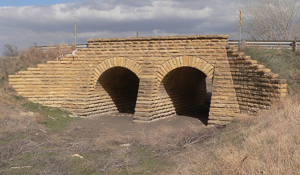
Built in 1928. Listed on the National Register of Historic Places in 1985.
One of 7 National Register listings published here for Ness County · listed in 1985 · category: Structure · built in 1928.
Sources: the National Register database, National Park Service
Regional context, not property-specific evidence. The National Weather Service names Bazine, the town this property stands in, in 110 storm reports between 1993 and 2025: 79 hail, 22 thunderstorm wind, 6 heavy rain, 2 flash flood. No death or injury is recorded in these reports. Each account below is quoted exactly as the forecast office filed it, from the NOAA Storm Events Database, and each date opens the federal record of that event.
| When | Event | Place named | Harm | What the report says |
|---|---|---|---|---|
| June 1995 | Hail | Bazine | $25,000 | no account filed |
| September 2006 | Hail | Bazine | $15,000 | There was significant damage done to the house siding. Dents were made in the steel siding. |
| June 1995 | Hail | Bazine | $10,000 | no account filed |
| April 1993 | Hail | Bazine | $5,000 | no account filed |
| June 2000 | Thunderstorm Wind | Bazine | $2,000 | Power poles and lines knocked down. |
| May 2025 | Thunderstorm Wind | Bazine | - | A public report estimated wind gusts at 60 mph. A mesonet site recorded a 56 mph gust shortly before the public report at the KKSNESSC2 observing station. |
| June 2023 | Thunderstorm Wind | Bazine | - | Public reported 60 mph wind estimate. |
| May 2021 | Thunderstorm Wind | Bazine | - | A large tree was blown down by the high wind. |
| April 2016 | Flood | Bazine | - | Multiple roads were flooded in the Bazine area. |
| October 2016 | Hail | Bazine | - | A few quarter sized stones were observed. |
| July 2015 | Thunderstorm Wind | Bazine | - | Winds were estimated to be 70 MPH. |
| June 2014 | Thunderstorm Wind | Bazine | - | Winds were estimated to be 60 MPH. |
| June 2014 | Thunderstorm Wind | Bazine | - | Tree limbs up to six inches in diameter were blown down by the high wind. |
| June 2014 | Thunderstorm Wind | Bazine | - | Winds were at least 70 MPH. |
| June 2014 | Hail | Bazine | - | There was also high wind with the hail. |
| March 2013 | Hail | Bazine | - | The hail ranged from nickel to quarter sized. There was only 0.16 of precipitation in the gauge after the event. |
| March 2013 | Hail | Bazine | - | Melting hailstones the size of nickels were still on the ground the next morning. |
| June 2012 | Thunderstorm Wind | Bazine | - | Winds were estimated to be 60 MPH. |
| May 2011 | Hail | Bazine | - | The hail broke holes in the fiberglass roof panels on a shed. |
| May 2011 | Hail | Bazine | - | The ground was white with the stones varying from pea to quarter size. |
| August 2009 | Hail | Bazine | - | The hail was accompanied by 70 mph winds. |
| August 2009 | Hail | Bazine | - | The hail was accompanied by 60 mph winds. |
| August 2009 | Thunderstorm Wind | Bazine | - | There was also dime to nickel sized hail. |
| August 2009 | Thunderstorm Wind | Bazine | - | There was also quarter sized hail. |
| June 2008 | Hail | Bazine | - | The large hail was mostly comprised of flat disks. |
| August 2008 | Heavy Rain | Bazine | - | Rainfall of 4.95 was measured. |
| October 2008 | Thunderstorm Wind | Bazine | - | Milo was blown over in the fields. |
| August 2006 | Heavy Rain | Bazine | - | 5.10 inches of rain fell overnight. |
| August 2006 | Heavy Rain | Bazine | - | 5.00 inches of rain fell overnight. Creeks were running full. |
| July 2006 | Heavy Rain | Bazine | - | Three inches of rain fell in a short period. |
| June 2006 | Thunderstorm Wind | Bazine | - | A large tree was blown over. |
| August 2006 | Heavy Rain | Bazine | - | 4.52 inches of rain fell overnight. |
| August 2006 | Heavy Rain | Bazine | - | 4.50 inches of rain fell overnight. Some county roads had water flowing over them. |
| September 2003 | Flash Flood | Bazine | - | Many roads in the northeast corner of the county had two to three feet of water flowing over them. |
| June 2002 | Hail | Bazine | - | Windows were broken out by the hail. |
| June 2001 | Flash Flood | Bazine | - | Water over county roads. |
| July 2000 | Thunderstorm Wind | Bazine | - | Three inch branches down. |
| May 1999 | Thunderstorm Wind | Bazine | - | Four to six inch diameter tree limbs down. |
| June 1999 | Thunderstorm Wind | Bazine | - | Recorded by wind equipment. |
| May 2023 | Hail | Bazine | - | no account filed |
| May 2023 | Hail | Bazine | - | no account filed |
| June 2023 | Hail | Bazine | - | no account filed |
| June 2022 | Hail | Bazine | - | no account filed |
| June 2022 | Hail | Bazine | - | no account filed |
| August 2020 | Hail | Bazine | - | no account filed |
| April 2019 | Hail | Bazine | - | no account filed |
| June 2018 | Hail | Bazine | - | no account filed |
| May 2018 | Hail | Bazine | - | no account filed |
| May 2018 | Hail | Bazine | - | no account filed |
| June 2017 | Hail | Bazine | - | no account filed |
| October 2017 | Hail | Bazine | - | no account filed |
| October 2017 | Hail | Bazine | - | no account filed |
| May 2015 | Hail | Bazine | - | no account filed |
| August 2014 | Hail | Bazine | - | no account filed |
| August 2014 | Hail | Bazine | - | no account filed |
| May 2013 | Hail | Bazine | - | no account filed |
| April 2013 | Hail | Bazine | - | no account filed |
| May 2012 | Hail | Bazine | - | no account filed |
| May 2012 | Hail | Bazine | - | no account filed |
| May 2012 | Hail | Bazine | - | no account filed |
No historic map-sheet match is published for this property yet. That does not mean no map exists. This record needs a coordinate-quality review before it can be joined to a sheet boundary. Browse the county's mapped places while that work is pending.
Other National Register properties close enough to walk or drive between, ordered by distance from this one. Both positions come from the same geocoding pass that matched these properties to their map sheets.
| Photograph | Property | Distance | Listed |
|---|---|---|---|
| Ness County Bridge FS-450 | 3.2 miles | 2017 |
| National Archives record | The nomination case file for reference 85001446 in Record Group 79. |
| Ness County | All 7 listed properties in this county. |