 Block
From the record
One of 11 National Register listings published here for Republic County · listed in 1989 · category: Building.
Sources: the National Register database, National Park Service
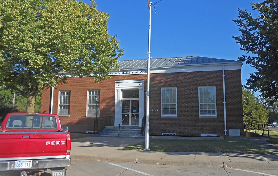
Listed on the National Register of Historic Places in 1989.
One of 11 National Register listings published here for Republic County · listed in 1989 · category: Building.
Sources: the National Register database, National Park Service
Regional context, not property-specific evidence. The federal wildfire occurrence database lists 1 fire within 5 miles of US Post Office-Belleville in 2018, burning about 2 acres in total. None started naturally. None was recorded as arson. Distance is straight-line from the map coordinates, so a fire counted here may appear on a neighbouring settlement's page as well.
| Reported cause | Fires |
|---|---|
| Debris and open burning | 1 |
The most recent of them, most recent first, with the day each was reported and the service that recorded it.
| Date | Cause | Size | Reported by | Name on the report |
|---|---|---|---|---|
| 6 April 2018 | Debris and open burning | 2.0 acres | Kansas Forest Service | 4 |
Regional context, not property-specific evidence. The National Weather Service names Belleville, the town this property stands in, in 94 storm reports between 1994 and 2026: 46 hail, 34 thunderstorm wind, 6 flash flood, 6 tornado. The reports record 2 injuries. Each account below is quoted exactly as the forecast office filed it, from the NOAA Storm Events Database, and each date opens the federal record of that event.
| When | Event | Place named | Harm | What the report says |
|---|---|---|---|---|
| April 2016 | Tornado (EF1) | Belleville | 2 hurt | Survey revealed that the initial tornado touchdown occurred around 650pm CDT just north of Belleville. The tornado then moved northeast and produced sporadic damage in rural areas of Republic County. It did hit the small town of Munden where several homes were damaged and a mobile home was destroyed. Another farmstead was also damaged northeast of Munden. The end of the tornado occurred south of Narka where some light tree damage was documented. |
| June 1998 | Thunderstorm Wind | Belleville | $775,000 | no account filed |
| May 2004 | Hail | Belleville | $75,000 | Large hail damaged windows and several vehicles in Belleville. |
| May 2004 | Tornado (F1) | Belleville | $50,000 | A tornado touched down near the southwest edge of Belleville and traveled 1/2 mile through parts of town before dissipating. The roof of a Dairy Queen was destroyed in Belleville. |
| May 2007 | Flash Flood | Belleville | $20,000 | Street flooding reported in Munden. 18 inches of water running over 220 Road near Munden. 8 to 10 inches of water over all of Main Street in south Belleville. Several other streets flooded in Belleville. Some cars stalled in the water. |
| April 2001 | Tornado (F1) | Belleville | $20,000 | A tornado touched down south of Belleville and moved northeast doing intermittant damage along a 10 mile path before dissipating. |
| May 2004 | Hail | Belleville | $10,000 | Large hail struck Belleville doing some damage to roofs of homes and vehicles. |
| May 1996 | Hail | Belleville | $10,000 | no account filed |
| April 1994 | Thunderstorm Wind | Belleville | $5,000 | Sixty mph winds blew a 40 to 50 foot section of roof off of a livestock sale barn. |
| July 1994 | Hail | Belleville | $5,000 | no account filed |
| July 1994 | Hail | Belleville | $5,000 | no account filed |
| July 2001 | Thunderstorm Wind | Belleville | $2,000 | Strong winds downed power lines, stree signs and trees. |
| July 2023 | Hail | Belleville | - | Nickel and quarter sized hail reported. |
| July 2023 | Thunderstorm Wind | Belleville | - | Wind gusts estimated between 50 and 60 mph. |
| July 2023 | Thunderstorm Wind | Belleville | - | Dispatch reported a couple of trees blown down across a road in town. |
| June 2020 | Thunderstorm Wind | Belleville | - | Telephone pole was snapped at the intersection of Highway 81 and M Street. |
| October 2020 | Thunderstorm Wind | Belleville | - | A few railroad cars blown over on Lincoln Road between 190 Road and 200 Road. One car blocking Lincoln Road. Time estimated. |
| July 2019 | Thunderstorm Wind | Belleville | - | Estimated wind gust. |
| May 2018 | Thunderstorm Wind | Belleville | - | Delayed report of power lines down with a few transformers damaged. At least one tree was uprooted with several large broken tree limbs across the town. Time was estimated via radar. |
| May 2018 | Thunderstorm Wind | Belleville | - | Davis weatherlink site observed wind gust. |
| May 2018 | Thunderstorm Wind | Belleville | - | Widespread tree limbs down in Belleville. The diameter of the tree limbs was unknown. |
| May 2018 | Tornado (EF0) | Belleville | - | Input from available data sources including radar, near storm environmental parameters and photos of damage suggest that at least some of the damage in Belleville could have been attributed to a brief weak tornado. Damage indicators only show EF0 damage with mainly tree limbs down. No structural damage was reported. |
| September 2018 | Thunderstorm Wind | Belleville | - | Several 2 inch diameter tree limbs down. Time was estimated based on radar. |
| May 2017 | Thunderstorm Wind | Belleville | - | Emergency manager reported a swath of straight line wind damage from roughly 1 mile south of Belleville to roughly 3 miles northeast of Belleville. Outbuilding and grain bins were damaged. Time was estimated by radar. |
| May 2016 | Hail | Belleville | - | Hail size determined via social media photo. |
| May 2016 | Hail | Belleville | - | Hail report via social media. |
| July 2015 | Thunderstorm Wind | Belleville | - | Wind gusts estimated. |
| July 2015 | Thunderstorm Wind | Belleville | - | Wind gusts estimated. |
| August 2015 | Thunderstorm Wind | Belleville | - | Wind gusts estimated. |
| May 2015 | Thunderstorm Wind | Belleville | - | Tree branch of 3 inches diameter was damaged due to wind. |
| August 2014 | Thunderstorm Wind | Belleville | - | Power lines down in the area. |
| August 2014 | Thunderstorm Wind | Belleville | - | Reports of power lines down and medium sized trees uprooted. |
| June 2014 | Thunderstorm Wind | Belleville | - | Power lines down. Law enforcement reported power outages in Belleville. |
| June 2009 | Hail | Belleville | - | Republic County sheriff reported golf ball size hail. |
| July 2009 | Thunderstorm Wind | Belleville | - | A tree of unknown diameter was blown onto 25th street blocking the roadway. The tree also knocked down a powerline. |
| May 2008 | Thunderstorm Wind | Belleville | - | A fence secured in the ground by concrete was blown down. |
| May 2008 | Thunderstorm Wind | Belleville | - | A shed was blown over near the begnning of the damage path, and a barn collapsed onto a tractor near the end. Trees were reported down along the path, and a home on Nickel Road has it's roof partially torn off. The same home had it's carport destroyed. Tree limbs were reported down across Belleville. A house near the intersection of N and 24th Streets had a large limb fall onto a nearby power line and porch. A wall on the south side of the Belleville Car Wash was also blown down by the strong winds. Wind damage continued along a swath from 6 miles south of Belleville to Hanover in Washington County. Near Hanover, minor damage was reported across the town. A tree fell onto the roof of a home on the west side of the home, causing damage to a home. |
| June 2008 | Hail | Belleville | - | Fifty mile per hour winds also reported. |
| August 2007 | Flash Flood | Belleville | - | Water one foot deep reported to be flowing over Lincoln Road. |
| June 2005 | Thunderstorm Wind | Belleville | - | Large tree limbs down in town. |
| June 2005 | Thunderstorm Wind | Belleville | - | Commercial dumpsters blown over. |
| August 2005 | Thunderstorm Wind | Belleville | - | Estimated by Sheriff Deputy on Highway 81. |
| May 2004 | Hail | Belleville | - | Large hail did extensive crop damage near Belleville. |
| May 2004 | Funnel Cloud | Belleville | - | A funnel cloud was sighted over Belleville. |
| May 2004 | Flash Flood | Belleville | - | Heavy rains of 2 to 4 inches produced runoff that flooded many roads for a time. |
| May 2004 | Tornado (F0) | Belleville | - | A tornado touched down briefly in open country. |
| June 2004 | Flash Flood | Belleville | - | Water was reported over a number of roads throughout Republic county. |
| May 2002 | Flash Flood | Belleville | - | Heavy rains produced flash flooding with water reported over the roadway at the junction of highways 81 and 36 near Belleville. |
| April 2026 | Hail | Belleville | - | no account filed |
| April 2026 | Hail | Belleville | - | no account filed |
| June 2020 | Hail | Belleville | - | no account filed |
| June 2020 | Hail | Belleville | - | no account filed |
| May 2016 | Hail | Belleville | - | no account filed |
| April 2010 | Hail | Belleville | - | no account filed |
| April 2010 | Hail | Belleville | - | no account filed |
| April 2010 | Hail | Belleville | - | no account filed |
| April 2009 | Hail | Belleville | - | no account filed |
| June 2008 | Hail | Belleville | - | no account filed |
| June 2008 | Thunderstorm Wind | Belleville | - | no account filed |
| April 2005 | Hail | Belleville | - | no account filed |
No historic map-sheet match is published for this property yet. That does not mean no map exists. This record needs a coordinate-quality review before it can be joined to a sheet boundary. Browse the county's mapped places while that work is pending.
Other National Register properties close enough to walk or drive between, ordered by distance from this one. Both positions come from the same geocoding pass that matched these properties to their map sheets.
| Photograph | Property | Distance | Listed |
|---|---|---|---|
 | Belleville High School | under 500 feet | 2013 |
 | S.T. Stevenson House | 0.3 miles | 2010 |
 | Republic County Courthouse | 0.6 miles | 2002 |
 | Riley Creek Bridge | 2.5 miles | 1990 |
 | East Riley Creek Bridge | 2.8 miles | 1990 |
| National Archives record | The nomination case file for reference 89001633 in Record Group 79. |
| Republic County | All 11 listed properties in this county. |