 Block
From the record
11 National Register listings published here.
Sources: the National Register database, National Park Service
28 topographic sheets cover 19 settlements here, and 11 properties are on the National Register of Historic Places.
11 National Register listings published here.
Sources: the National Register database, National Park Service
Every property in this county listed on the National Register of Historic Places, with the year it was listed and the federal nomination document.
| Photograph | Property | Type | Listed | Reference |
|---|---|---|---|---|
 | Belleville High School | building | 2013 | 13000434 |
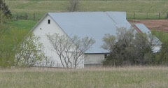 | Cossaart Barn | building | 2009 | 09001166 |
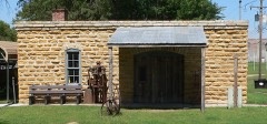 | Cuba Blacksmith Shop | building | 2009 | 09000810 |
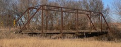 | East Riley Creek Bridge | structure | 1990 | 89002176 |
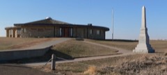 | Pawnee Indian Village Site | site | 1971 | 71000325 |
 | Republic County Courthouse | building | 2002 | 02000393 |
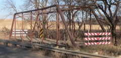 | Riley Creek Bridge | structure | 1990 | 89002175 |
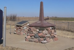 | Site No. JF00-072 | site | 1987 | 87001000 |
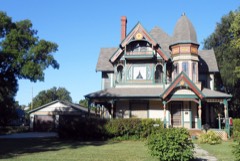 | S.T. Stevenson House | building | 2010 | 10000451 |
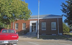 | US Post Office-Belleville | building | 1989 | 89001633 |
| Woodland Place Stock Farm | district | 2015 | 15000938 |
Every wildfire the federal occurrence database records inside this county: 26 of them, burning about 309 acres. None started naturally and none was recorded as arson. Each settlement page carries the fires within five miles of it.
| Reported cause | Fires |
|---|---|
| Debris and open burning | 12 |
| Missing data/not specified/undetermined | 6 |
| Equipment and vehicle use | 4 |
| Power generation/transmission/distribution | 3 |
| Smoking | 1 |
The five largest, by the area the report gives. None of them was recorded as arson.
| Date | Cause | Size | Reported by | Name on the report |
|---|---|---|---|---|
| 16 February 2017 | Debris and open burning | 80 acres | Republic County | 1700002 |
| 16 March 2015 | Power generation/transmission/distribution | 50 acres | Kansas Forest Service | 1500015 |
| 20 December 2015 | Power generation/transmission/distribution | 40 acres | Kansas Forest Service | 1500025 |
| 18 February 2018 | Missing data/not specified/undetermined | 40 acres | Kansas Forest Service | 1800002 |
| 5 March 2018 | Missing data/not specified/undetermined | 30 acres | Kansas Forest Service | 1800003 |
| 20 October 2015 | Equipment and vehicle use | 22 acres | Kansas Forest Service | 1500022 |
| 26 February 2018 | Debris and open burning | 10 acres | Kansas Forest Service | 1800004 |
| 15 February 2018 | Debris and open burning | 10 acres | Kansas Forest Service | 595 |
Every settlement page carries the fires within five miles of it - see the settlement index below.
The NOAA Storm Events Database holds 646 reports for this county, causing no deaths, 13 injuries and about $16,177,000 in recorded property damage. Each settlement page carries the reports that name it.
| Kind of event | Reports |
|---|---|
| Hail | 348 |
| Thunderstorm Wind | 193 |
| Tornado | 70 |
| Flash Flood | 24 |
| Funnel Cloud | 6 |
| Lightning | 3 |
| Heavy Rain | 2 |
The most serious of them, by death, then injury, then recorded damage. The accounts are quoted exactly as the forecast office filed them.
| When | Event | Place named | Harm | What the report says |
|---|---|---|---|---|
| May 2010 | Thunderstorm Wind | Courtland | 10 hurt | Numerous trees were blown down. Powers lines were blown down in town. A total for 4 buildings on the north edge of town were blown down. |
| April 2016 | Tornado (EF1) | Belleville | 2 hurt | Survey revealed that the initial tornado touchdown occurred around 650pm CDT just north of Belleville. The tornado then moved northeast and produced sporadic damage in rural areas of Republic County. It did hit the small town of Munden where several homes were damaged and a mobile home was destroyed. Another farmstead was also damaged northeast of Munden. The end of the tornado occurred south of Narka where some light tree damage was documented. |
| April 1976 | Tornado (F2) | not stated | 1 hurt, $250,000 | no account filed |
| June 2003 | Flash Flood | Republic | $3,400,000 | Thunderstorms persisted over north and west parts of Republic county the night of the 22nd. Rainfall amounts in excess of 12 inches were reported in some areas. The resulting runoff caused flash flooding. Water was 3 to 4 feet deep on some roadways and vehicles were washed off roadways and rescue efforts made of the vehicles occupants. Several roads were completely washed out. Two homes were destroyed by the floodwaters. Deer and cattle were reported swimming. Some people were stranded in homes and in need of rescue. Fields were flooded and there was severe crop damage. The runoff caused the Republican River to rise quickly and overflow. It was reported to be 1 mile wide in places. The river crested at 15 feet at Scandia early in the morning of the 23rd. Flood stage is 10 feet. |
| May 2004 | Tornado (F1) | Norway | $3,200,000 | A tornado touched down southwest of Norway and moved over 3 miles northeast before dissipating. Along the path of the tornado extensive damage was done, including significant crop damage. A number of power poles were downed. Many farm houses were severely damaged. Many farm implements and outbuildings were damaged or destroyed. Near Norway irrigation equipment was wrapped around a utility pole. In Norway a grain bin was blown over. Many homes in Norway sustained considerable damage. Many trees were downed along the tornado path. |
| March 1990 | Tornado (F2) | not stated | $2,500,000 | no account filed |
| September 1986 | Tornado (F3) | not stated | $2,500,000 | no account filed |
| May 2008 | Tornado (EF3) | Courtland | $1,000,000 | The tornado crossed from Jewell County into Republic County 4 miles South Southwest of Courtland. There, tree damage was noted, and several outbuildings were destroyed at a residence. An old rock home was also destroyed. Significant tree, power pole, and power line damage was reported along the path. Several of these trees had been uprooted and thrown for several hundred feet. Irrigation units were destroyed. Several homes, a newspaper reported at least six, were damaged along the path. The home that sustained the most significant damage had portions of the roof removed, and it's eastern wall blown out. Barns, outbuildings, and grain bins were destroyed at the residence as well. The old Union Valley Schoolhouse was demolished, and several headstones and trees in the Union Valley Cemetary were blown down. The tornado was rated EF-3 when it entered the county. Local Emergency Management reported that several residents had to be rescued after the tornado because of debris and damage to their homes. Highway 36 was closed through Friday morning because of power poles and power lines on the roadway. Between Hwy 81 and a point two miles south of the state line along the path, EF-2 damage was surveyed. Thereafter, EF-1 damage was noted. The tornado exited Republic County and entered Thayer County 5 miles west northwest of Narka. |
| June 1998 | Thunderstorm Wind | Belleville | $775,000 | no account filed |
| July 1994 | Thunderstorm Wind | Bellevile | $500,000 | Strong thunderstorm winds caused extensive tree and structural damage in the area. |
| March 1990 | Tornado (F1) | not stated | $250,000 | no account filed |
| April 1986 | Tornado (F0) | not stated | $250,000 | no account filed |
| June 2003 | Tornado (F1) | Courtland | $125,000 | The third in a series of tornadoes touched down northeast of Courtland and traveled 3 miles and damaged 2 homes before dissipating. |
| June 2001 | Tornado (F1) | Munden | $120,000 | A tornado formed just north of Munden and moved northeast doing considerable damage to several farmsteads before moving into Nebraska. |
| May 2004 | Tornado (F2) | Republic | $90,000 | A tornado touched down at the Pawnee Indian Museum and damaged a roof to the museum building before moving 2 miles and lifting at the edge of Republic. Along the tornado's path a windmill was destroyed, power lines were downed, and 3 center pivoting irrigation systems were damaged. A one ton granite memorial at the Pawnee Indian Museum was moved 8 feet off the foundation. |
| June 2003 | Tornado (F2) | Republic | $80,000 | A tornado struck 3 miles northeast of Republic and moved northeast 4 miles and destroyed a house in its path before it dissipated near the Nebraska border. |
| May 2004 | Hail | Belleville | $75,000 | Large hail damaged windows and several vehicles in Belleville. |
| July 2007 | Flash Flood | Agenda | $70,000 | Water over state highway 148 in Agenda...estimated at 1 to 2 feet deep. |
| June 2003 | Tornado (F1) | Republic | $60,000 | A fourth tornado touched down near Republic and moved northeast for 2 miles and damaged a home before dissipating. |
| April 2001 | Tornado (F1) | Courtland | $60,000 | A tornado moved from east central Jewell County into Republic County and struck the town of Courtland before dissipating near the town of Republic. Considerable damage occurred to power lines and farm outbuildings along the path of the tornado. Considerable damage occurred to several buildings in the town of Courtland as well. |
| May 2007 | Flash Flood | Republic | $50,000 | Water flowing over Fir road one-half mile east of the city of Republic...as well as 2 miles west of highway 81 on Fir road. |
| July 2006 | Flash Flood | Courtland | $50,000 | A deputy reported fast flowing water up to 6 inches deep over HWY 266 about 2 miles Northeast of Courtland. Also a deputy reported fast flowing water up to 6 inches deep over several county roads 1 to 2 miles northwest of Courtland. The flash flooding occurred with up to 4.75 inches of rain. |
| August 2005 | Flash Flood | Republic | $50,000 | Fast flowing water over secondary roads. |
| June 2005 | Flash Flood | West Portion | $50,000 | At least 6 inches of fast flowing water across several rural roads western part of the county. |
| October 2005 | Heavy Rain | Norway | $50,000 | Intense brief heavy rain estimated at one to two inches brought urban and small stream flooding. Several rural roads had shallow ponded water over them including K-148. |
| May 2004 | Tornado (F1) | Belleville | $50,000 | A tornado touched down near the southwest edge of Belleville and traveled 1/2 mile through parts of town before dissipating. The roof of a Dairy Queen was destroyed in Belleville. |
| June 2003 | Tornado (F0) | Courtland | $50,000 | A tornado touched down in rural areas near Courtland and moved northeast about one half mile and struck a farm before dissipating. Several outbuildings at the farm were damaged. |
| June 2001 | Tornado (F0) | Narka | $45,000 | A tornado formed southwest of Narka and moved northeast doing some damage to the community of Narka before crossing into Nebraska. |
| July 2007 | Flash Flood | Munden | $30,000 | Water flowing over roadway in Munden...estimated up to 6 inches deep. Two inches of rain fell in about an hour. |
| March 2004 | Thunderstorm Wind | Cuba | $30,000 | Strong winds blew a 300 gallon fuel tank on top of a car. A barn was moved 12 feet off its foundation, and several feed bins were blown on top of the barn. |
| October 1998 | Lightning | Scandia | $25,000 | According to the Scandia Journal the farmhouse owned by Landy Hay was severely burned when lightning struck a nearby fence charger igniting a fire that burned the house. |
| September 1983 | Tornado (F0) | not stated | $25,000 | no account filed |
| June 1979 | Tornado (F0) | not stated | $25,000 | no account filed |
| June 1979 | Tornado (F1) | not stated | $25,000 | no account filed |
| May 1961 | Tornado (F2) | not stated | $25,000 | no account filed |
| May 1953 | Tornado (F3) | not stated | $25,000 | no account filed |
| May 1952 | Tornado (F2) | not stated | $25,000 | no account filed |
| May 2010 | Thunderstorm Wind | Agenda | $20,000 | Numerous power lines were blown down around town. A carport was blown onto the roof of a home. A travel trailer was blown on its side. |
| May 2007 | Flash Flood | Belleville | $20,000 | Street flooding reported in Munden. 18 inches of water running over 220 Road near Munden. 8 to 10 inches of water over all of Main Street in south Belleville. Several other streets flooded in Belleville. Some cars stalled in the water. |
| June 2003 | Tornado (F0) | Courtland | $20,000 | A second tornado touched down northeast of Courtland, moved northeast for a mile and damaged some power poles and power lines before dissipating. |
| April 2001 | Tornado (F1) | Belleville | $20,000 | A tornado touched down south of Belleville and moved northeast doing intermittant damage along a 10 mile path before dissipating. |
| May 2004 | Hail | Belleville | $10,000 | Large hail struck Belleville doing some damage to roofs of homes and vehicles. |
| May 1996 | Hail | Belleville | $10,000 | no account filed |
| May 2004 | Tornado (F0) | Republic | $9,000 | A tornado touched down briefly at a farm and damaged a barn. |
| August 2000 | Thunderstorm Wind | Narka | $6,000 | Strong winds blew the roof off of a barn and damaged several outbuildings at 2 farms. |
| June 2009 | Hail | Norway | $5,000 | Republic County sheriff reported baseball size hail with damage to cars noted. The damage estimate is approximate for this report. |
| May 2006 | Flash Flood | Republic | $5,000 | Up to 4.5 inches of rain produced fast flowing water over a road on the west side of town, and the highway department was barricading the road. |
| May 2004 | Tornado (F0) | Munden | $5,000 | A tornado touched down briefly in Munden and damaged a few homes. |
| June 2003 | Tornado (F0) | Munden | $5,000 | A tornado touched down 4 miles west of Munden and blew a sheriffs car into the ditch before dissipating. |
| April 2001 | Thunderstorm Wind | Agenda | $5,000 | Thunderstorm winds blew down power lines. |
| July 2001 | Thunderstorm Wind | Cuba | $5,000 | Strong winds destroyed a garage. |
| August 1999 | Thunderstorm Wind | Wayne | $5,000 | Thunderstorm winds near 70 mph caused some property damage in the town of Wayne. |
| June 1994 | Thunderstorm Wind | Courtland | $5,000 | High winds snapped power pole in half in this area. |
| April 1994 | Thunderstorm Wind | Belleville | $5,000 | Sixty mph winds blew a 40 to 50 foot section of roof off of a livestock sale barn. |
| June 1994 | Thunderstorm Wind | Courtland | $5,000 | High winds snapped power pole in half in this area. |
| June 1994 | Thunderstorm Wind | Republic | $5,000 | High winds caused significant tree damage. |
| July 1994 | Thunderstorm Wind | Narka | $5,000 | Large tree limbs were blown in this area by strong thunderstorm winds. |
| July 1994 | Thunderstorm Wind | Courtland | $5,000 | no account filed |
| July 1994 | Hail | Belleville | $5,000 | no account filed |
| July 1994 | Hail | Agenda | $5,000 | no account filed |
Named settlements recorded in the Geographic Names Information System, each with the topographic sheets covering it. Villages, hamlets and abandoned places alike. Each is shown with the nearest named watercourse or landform and the survey quadrangle it falls on.