 Block
From the record
One of 21 National Register listings published here for Chase County · listed in 1990 · category: District.
Sources: the National Register database, National Park Service
Listed on the National Register of Historic Places in 1990.
One of 21 National Register listings published here for Chase County · listed in 1990 · category: District.
Sources: the National Register database, National Park Service
Regional context, not property-specific evidence. The federal wildfire occurrence database lists 7 fires within 5 miles of Pioneer Bluffs Ranch Historic District between 2002 and 2018, burning about 33,930 acres in total. None started naturally. None was recorded as arson. Distance is straight-line from the map coordinates, so a fire counted here may appear on a neighbouring settlement's page as well.
| Reported cause | Fires |
|---|---|
| Debris and open burning | 3 |
| Missing data/not specified/undetermined | 2 |
| Equipment and vehicle use | 1 |
| Smoking | 1 |
The most recent of them, most recent first, with the day each was reported and the service that recorded it.
| Date | Cause | Size | Reported by | Name on the report |
|---|---|---|---|---|
| 5 April 2018 | Missing data/not specified/undetermined | 2,500 acres | Chase County | NICKEL CREEK |
| 29 April 2015 | Debris and open burning | 5.0 acres | Kansas Forest Service | 31 |
| 28 March 2015 | Debris and open burning | 25 acres | Kansas Forest Service | 19 |
| 27 March 2002 | Missing data/not specified/undetermined | 30,000 acres | Chase County | not named |
| 21 March 2015 | Smoking | 185 acres | Kansas Forest Service | 13 |
| 11 March 2015 | Debris and open burning | 65 acres | Kansas Forest Service | 8 |
| 8 January 2017 | Equipment and vehicle use | 1,150 acres | Chase County | 2 |
Regional context, not property-specific evidence. The National Weather Service names Matfield Green, the town this property stands in, in 40 storm reports between 1998 and 2024: 23 thunderstorm wind, 11 hail, 3 flood, 1 tornado. The reports record 9 injuries. Each account below is quoted exactly as the forecast office filed it, from the NOAA Storm Events Database, and each date opens the federal record of that event.
| When | Event | Place named | Harm | What the report says |
|---|---|---|---|---|
| May 2003 | Thunderstorm Wind | Matfield Green | 6 hurt, $380,000 | Severe thunderstorm winds derailed 38 cars of a 118-car Burlington Northern Santa Fe freight train. One of the derailed freight cars, a unibody tank car filled with sulphur dioxide, forced the evacuation of an estimated 250 residents. Six firemen and law enforcement officers, exact number of each unknown, were treated at the scene for respiratory ailments. |
| October 2017 | Lightning | Matfield Green | 3 hurt | Three state transportation workers were injured, while working along the Kansas Turnpike, when their vehicle was struck by lightning. One worker was inside the vehicle, while two others were nearby. All three of the employees were taken to the hospital, two were treated and released, while the other was hospitalized in fair condition. |
| May 2009 | Flood | Matfield Green | $100,000 | Three to four inches of rainfall caused flooding across the county. Numerous low water crossings were flooded with portions of the Kansas Turnpike near mile post 101 closed because of high water. |
| September 2014 | Thunderstorm Wind | Matfield Green | $10,000 | Tree limbs of unknown size were blown down on Highway 177 near Matfield Green. The limbs were large enough that a chainsaw was needed to cut them up. |
| September 2014 | Thunderstorm Wind | Matfield Green | $10,000 | A tree fell on the Kansas Turnpike on the south bound side at Mile Marker 101. |
| August 2000 | Thunderstorm Wind | Matfield Green | $5,000 | Roof damage and large limbs downed. |
| May 2008 | Thunderstorm Wind | Matfield Green | $500 | A few shingles were blown off a roof. |
| May 2024 | Thunderstorm Wind | Matfield Green | - | A cedar tree was blown over. |
| June 2024 | Thunderstorm Wind | Matfield Green | - | Storm chaser reported an estimated wind gust of 70 mph along Kansas Highway 177. |
| September 2024 | Thunderstorm Wind | Matfield Green | - | Measured by an anemometer along the Kansas Turnpike. |
| April 2023 | Hail | Matfield Green | - | Hail covered the ground with winds gusting to around 50 mph. |
| August 2023 | Thunderstorm Wind | Matfield Green | - | Measured wind gust of 55kts. |
| October 2023 | Heavy Rain | Matfield Green | - | A mesonet station 2 north of Matfield Green measured 5.11 inches of rain in the past 24 hours. Rainfall amounts around the county ranged from 2.5 to 5.11 inches. |
| June 2022 | Thunderstorm Wind | Matfield Green | - | This was a measured gust. |
| December 2021 | Thunderstorm Wind | Matfield Green | - | This was reported as an estimated gust. |
| April 2019 | Thunderstorm Wind | Matfield Green | - | There were multiple media reports of a 21-car train derailment. There were no reports of injuries or whether or not any of the cars were transporting hazardous materials. |
| October 2017 | Thunderstorm Wind | Matfield Green | - | Winds were estimated by a storm chaser. |
| March 2016 | Hail | Matfield Green | - | The hail occurred at the Matfield Green service plaza on the Kansas Turnpike. |
| July 2016 | Tornado (EF0) | Matfield Green | - | A very brief touchdown of 15 seconds was reported over open country. |
| July 2013 | Flood | Matfield Green | - | The Kansas Turnpike was closed briefly between mileposts 90 and 110. It was reopened. |
| July 2010 | Thunderstorm Wind | Matfield Green | - | Winds were estimated at 50 to 60 mph. |
| August 2008 | Flood | Matfield Green | - | Water was flowing over Highway 177 north of Matfield Green. |
| August 2001 | Thunderstorm Wind | Matfield Green | - | Widespread tree damage. |
| July 2024 | Thunderstorm Wind | Matfield Green | - | no account filed |
| May 2015 | Thunderstorm Wind | Matfield Green | - | no account filed |
| June 2012 | Thunderstorm Wind | Matfield Green | - | no account filed |
| April 2010 | Hail | Matfield Green | - | no account filed |
| June 2009 | Thunderstorm Wind | Matfield Green | - | no account filed |
| May 2007 | Thunderstorm Wind | Matfield Green | - | no account filed |
| May 2004 | Hail | Matfield Green | - | no account filed |
| May 2004 | Thunderstorm Wind | Matfield Green | - | no account filed |
| May 2004 | Hail | Matfield Green | - | no account filed |
| June 2003 | Thunderstorm Wind | Matfield Green | - | no account filed |
| June 2003 | Hail | Matfield Green | - | no account filed |
| June 2003 | Hail | Matfield Green | - | no account filed |
| July 2003 | Hail | Matfield Green | - | no account filed |
| August 2001 | Thunderstorm Wind | Matfield Green | - | no account filed |
| August 2000 | Hail | Matfield Green | - | no account filed |
| June 1998 | Hail | Matfield Green | - | no account filed |
| June 1998 | Hail | Matfield Green | - | no account filed |
No historic map-sheet match is published for this property yet. That does not mean no map exists. This record needs a coordinate-quality review before it can be joined to a sheet boundary. Browse the county's mapped places while that work is pending.
Other National Register properties close enough to walk or drive between, ordered by distance from this one. Both positions come from the same geocoding pass that matched these properties to their map sheets.
| Photograph | Property | Distance | Listed |
|---|---|---|---|
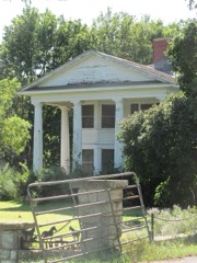 | Crocker Ranch | 0.5 miles | 1977 |
| Matfield Green High School Gymnasium | 1.1 miles | 2024 |
| National Archives record | The nomination case file for reference 90001441 in Record Group 79. |
| Chase County | All 21 listed properties in this county. |