 Block
From the record
One of 14 National Register listings published here for Osage County · listed in 1995 · category: Building.
Sources: the National Register database, National Park Service
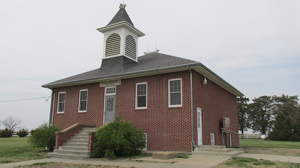
Listed on the National Register of Historic Places in 1995.
One of 14 National Register listings published here for Osage County · listed in 1995 · category: Building.
Sources: the National Register database, National Park Service
Regional context, not property-specific evidence. The federal wildfire occurrence database lists 26 fires within 5 miles of Rapp School District No. 50 between 2015 and 2019, burning about 333 acres in total. None started naturally. 1 was recorded as arson. Distance is straight-line from the map coordinates, so a fire counted here may appear on a neighbouring settlement's page as well.
| Reported cause | Fires |
|---|---|
| Debris and open burning | 15 |
| Missing data/not specified/undetermined | 10 |
| Arson/incendiarism | 1 |
The most recent of them, most recent first, with the day each was reported and the service that recorded it.
| Date | Cause | Size | Reported by | Name on the report |
|---|---|---|---|---|
| 24 July 2018 | Missing data/not specified/undetermined | 5.0 acres | Kansas Forest Service | 018-043 |
| 10 July 2018 | Debris and open burning | 4.0 acres | Kansas Forest Service | 180150 |
| 30 June 2015 | Debris and open burning | 5.0 acres | Kansas Forest Service | 163 |
| 3 June 2018 | Debris and open burning | under an acre | Kansas Forest Service | 180121 |
| 4 April 2018 | Debris and open burning | under an acre | Kansas Forest Service | 180079 |
| 29 April 2018 | Missing data/not specified/undetermined | under an acre | Kansas Forest Service | 180105 |
| 24 April 2018 | Debris and open burning | under an acre | Kansas Forest Service | 180098 |
| 17 April 2018 | Missing data/not specified/undetermined | 3.0 acres | Kansas Forest Service | 180092 |
Regional context, not property-specific evidence. The National Weather Service names Osage City, the town this property stands in, in 123 storm reports between 1994 and 2025: 65 hail, 45 thunderstorm wind, 6 flash flood, 3 tornado. No death or injury is recorded in these reports. Each account below is quoted exactly as the forecast office filed it, from the NOAA Storm Events Database, and each date opens the federal record of that event.
| When | Event | Place named | Harm | What the report says |
|---|---|---|---|---|
| May 2003 | Tornado (F3) | Osage City | $1,500,000 | A second tornado touched down in Osage county about 13 miles southwest of Lyndon and moved northeast for 25 miles before dissipating 6 miles south of Overbrook. The tornado was a half mile wide in places and did considerable damage to farm buildings, machinery, and fences along its path. |
| June 2005 | Flash Flood | Osage City | $100,000 | At least 6 inches of fast flowing water across roads in the Osage City area. |
| June 2005 | Heavy Rain | Osage City | $50,000 | Two to seven inches of rain caused lowland and small stream flooding. |
| July 1994 | Thunderstorm Wind | Osage City | $50,000 | High winds knocked down trees, power lines and damaged some buildings. Power in some areas was out for 24 hours. |
| March 2007 | Flash Flood | Osage City | $1,000 | Water up to 2 feet deep reported to be running over Hwy 56 between Osage City and Burlingame. |
| May 2005 | Flash Flood | Osage City | $500 | Report of fast flowing water over k-31 highway. |
| May 2005 | Flash Flood | Osage City | $500 | Intense rains brought fast flowing water across streets and roads around Osage City. |
| September 2025 | Hail | Osage City | - | Report from mping in Osage City. |
| September 2025 | Hail | Osage City | - | Report from mping in Osage City. |
| May 2024 | Thunderstorm Wind | Osage City | - | Trained spotter reported sustained winds of around 60 mph with gusts to around 70 mph. |
| June 2024 | Thunderstorm Wind | Osage City | - | Large tree snapped in Osage City. |
| May 2023 | Thunderstorm Wind | Osage City | - | Report of 11 inch diameter tree limb down. |
| May 2023 | Hail | Osage City | - | Quarter sized hail reported. |
| May 2022 | Hail | Osage City | - | Golf ball sized hail reported. |
| March 2021 | Hail | Osage City | - | We received a report from mPING of quarter size hail. |
| September 2020 | Hail | Osage City | - | Report received via mping. |
| September 2020 | Hail | Osage City | - | Spotter reported hail accumulating on the ground. |
| August 2019 | Thunderstorm Wind | Osage City | - | Wind gusts to around 60 mph. |
| August 2019 | Thunderstorm Wind | Osage City | - | Wind gusts to around 60 mph estimated. |
| August 2019 | Thunderstorm Wind | Osage City | - | Large tree limbs down in the city. Time estimated from radar data. |
| May 2019 | Thunderstorm Wind | Osage City | - | Power poles reported breaking on the north side of Osage City. |
| May 2019 | Thunderstorm Wind | Osage City | - | Picture on social media shows a very large tree uprooted with estimated 80 mph winds. |
| May 2019 | Thunderstorm Wind | Osage City | - | Wind gust was measured via a personal weather station. |
| May 2019 | Tornado (EFU) | Osage City | - | Report of rotation and debris lofted aloft. Subsequent follow up revealed no damage however had eyewitness of small brief tornado in field. Time based on radar and report. |
| May 2019 | Thunderstorm Wind | Osage City | - | Estimated wind gust report. |
| August 2016 | Thunderstorm Wind | Osage City | - | Estimated wind gust. |
| May 2015 | Thunderstorm Wind | Osage City | - | Wind gusts estimated. |
| May 2015 | Flash Flood | Osage City | - | Water was running over the spillway of the Osage city reservoir and over 4th street verified on social media. |
| September 2015 | Thunderstorm Wind | Osage City | - | Wind gusts estimated. |
| September 2015 | Thunderstorm Wind | Osage City | - | Dispatch reported trees and power lines down in Osage city. |
| May 2013 | Thunderstorm Wind | Osage City | - | Wind estimated. |
| February 2012 | Thunderstorm Wind | Osage City | - | A trained spotter in Osage City reported a measured 67 mph wind gust. Another spotter near Lyndon reported an estimated 60 mph wind gust. |
| August 2010 | Thunderstorm Wind | Osage City | - | Trained spotters across Osage County reported 65 mph wind gusts. |
| June 2010 | Thunderstorm Wind | Osage City | - | Trained spotters from Osage City reported estimated 75 mph wind gusts. No damage from the city was reported. |
| August 2010 | Thunderstorm Wind | Osage City | - | Trained spotters in Osage City reported 70 mph wind gusts. Some small tree limbs were also broken across town due to the wind. |
| July 2010 | Thunderstorm Wind | Osage City | - | Lawn ornaments were blown around at a residence in Osage City. A trained spotter reported an estimated 70 mph wind gust near Waverly. |
| March 2009 | Hail | Osage City | - | Quarter and nickel size hail reported by a trained spotter. |
| June 2009 | Thunderstorm Wind | Osage City | - | A trained spotter reported 75 mph winds. |
| April 2008 | Thunderstorm Wind | Osage City | - | Estimated 60mph winds blew over a row of Port-a-Potties. |
| April 2008 | Thunderstorm Wind | Osage City | - | The roof was blown off of a repair shop. Just west of this location, a pole barn was blown over. An Osage City car dealership also reported damage with the severe thunderstorms. |
| July 2008 | Hail | Osage City | - | Several reports of golfball size hail south of Osage City. |
| June 2008 | Hail | Osage City | - | Hail slightly larger than quarters fell and dented vehicles in both Osage City and Olivet. |
| June 2007 | Heavy Rain | Osage City | - | Rainfall totals were estimated to have exceeded three inches in approximately 2 hours across portions of Osage County, including Osage City. Several streets were reported to have been flooded in Osage City, but none were closed. Roads across the county were reported to have standing water on them due to the heavy rain. |
| August 2007 | Thunderstorm Wind | Osage City | - | Lawn furniture blowing around. |
| June 2006 | Thunderstorm Wind | Osage City | - | Strong thunderstorm winds blew down several trees in Osage City and knocked out power to some homes. |
| August 2006 | Thunderstorm Wind | Osage City | - | Considerable tree and property damage from strong winds. Some metal sheds collapsed and an RV storage building was blown 50 yards. Power lines were downed. |
| August 2006 | Thunderstorm Wind | Osage City | - | A 9 inch diameter tree limb was blown down, which knocked down power lines and damaged a car on Market Street. |
| August 2005 | Thunderstorm Wind | Osage City | - | Tree down across 3rd Street and power pole down across Elmwood. |
| September 2005 | Hail | Osage City | - | Reported at a golf course. |
| May 2004 | Funnel Cloud | Osage City | - | A funnel cloud was sighted near Osage City. |
| May 2002 | Thunderstorm Wind | Osage City | - | Several 2 foot diameter trees were uprooted by strong winds. |
| May 2002 | Flash Flood | Osage City | - | Heavy rains produced flash flooding in Osage county. Street flooding was reported in Osage City and a car was washed off a roadway near Osage City. |
| August 1998 | Thunderstorm Wind | Osage City | - | An 18" diameter walnut tree was downed and several 5" branches on other nearby trees were broken off. |
| April 2025 | Hail | Osage City | - | no account filed |
| April 2025 | Hail | Osage City | - | no account filed |
| July 2019 | Hail | Osage City | - | no account filed |
| August 2019 | Hail | Osage City | - | no account filed |
| August 2019 | Hail | Osage City | - | no account filed |
| August 2019 | Hail | Osage City | - | no account filed |
| September 2015 | Hail | Osage City | - | no account filed |
No historic map-sheet match is published for this property yet. That does not mean no map exists. This record needs a coordinate-quality review before it can be joined to a sheet boundary. Browse the county's mapped places while that work is pending.
Other National Register properties close enough to walk or drive between, ordered by distance from this one. Both positions come from the same geocoding pass that matched these properties to their map sheets.
| Photograph | Property | Distance | Listed |
|---|---|---|---|
 | Osage City Santa Fe Depot | 4.7 miles | 1989 |
| Star Block | 4.8 miles | 2020 | |
| Samuel Hunt Grave | 7.1 miles | 1995 | |
| Luther Severy & Son Stock Farm | 7.2 miles | 2023 |
| National Archives record | The nomination case file for reference 95000944 in Record Group 79. |
| Osage County | All 14 listed properties in this county. |