BlockBefore
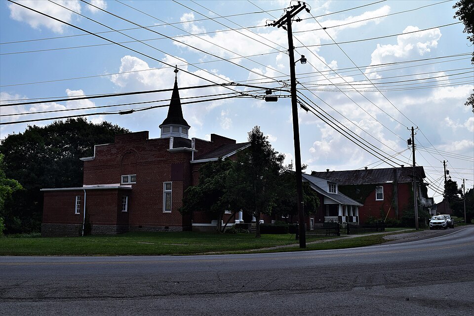
Photograph of New Liberty Historic District
Photograph by TheCatalyst31, CC0 1.0. Via Wikimedia Commons.

New Liberty Historic District

Listed on the National Register of Historic Places in 2001.

From the record

“The New Liberty Historic District in New Liberty, Kentucky is a 29.5 acres (11.9 ha) historic district which was listed on the National Register of Historic Places in 2001. It is located along Kentucky Route 227, roughly between KY 978 and KY 36.”

Wikipedia article New Liberty Historic District, CC BY-SA 4.0.

One of 17 National Register listings published here for Owen County · listed in 2001 · category: District.

Sources: the Wikipedia article · the case file at the National Archives · the National Register database, National Park Service

The listing

  • Address. KY 227, roughly bet. KY 978 and KY 36, New Liberty, 41098
  • When was it listed? January 2001
  • Category. district
  • Census division. New Liberty
  • National Register reference number. 00001601 - the number the National Park Service assigned this property when it was listed, and the key its nomination file is catalogued under at the National Archives.

Mines and quarries near this property

1 within 5 miles

Regional context, not property-specific evidence. The federal mineral resources record lists 1 working within 5 miles of New Liberty Historic District: 1 past producer. None of them still produces. What was taken out: Lead, Barium-Barite, Zinc. Distance is straight-line from the map coordinates, so a quarry counted here may appear on a neighbouring settlement's page as well.

Where SiteCommodity StatusRecorded
Waits MineLead, Barium-Barite, ZincPast Producer1904, 1940

Every working recorded in Owen County

Storms near this property

25 since 1998

Regional context, not property-specific evidence. The National Weather Service names New Liberty, the town this property stands in, in 25 storm reports between 1998 and 2024: 14 thunderstorm wind, 5 hail, 2 flash flood, 2 flood. The reports record 4 injuries. Each account below is quoted exactly as the forecast office filed it, from the NOAA Storm Events Database, and each date opens the federal record of that event.

WhenEvent Place namedHarm What the report says
March 2012Tornado (EF2)New Liberty3 hurt, $320,000The tornado touched down north of Owenton initially near a farm south of Highway 227, where minor damage to a barn and house were observed. The tornado continued east to near the intersection of Todd Road and Highways 127, 36, and 227 where the EF2 damage occurred. This damage included a house that had complete removal of the roof and partial exterior wall collapse. Numerous barns in the area were also completely destroyed. Power poles and trees were snapped, as well as a semi trailer overturned. The tornado then continued east across Kemper Lane where more barns were destroyed and numerous groves of trees were uprooted and snapped. The tornado lifted just east of Jonesville Road. This location is approximate due to inaccessible terrain. Damage in the area of Jonesville Road consisted of minor damage to outbuildings, tree damage, and minor removal of roofing material. Based on the damage survey, the maximum wind speed of this tornado was estimated to be 125 miles per hour.
April 2002LightningNew Liberty1 hurtA person received minor injuries from a lightning strike. Time is estimated.
April 2011Thunderstorm WindNew Liberty$15,000Trees were across the highway and roofs were off outbuildings due to damaging thunderstorm winds.
August 2009Flash FloodNew Liberty$10,000Two people were rescued from their vehicle trapped on a flooded bridge on Big Twin Creek Road.
February 2002Thunderstorm WindNew Liberty$10,000A barn sustained severe roof damage in the northern part of the county.
March 2016Thunderstorm WindNew Liberty$5,000An estimated 10 to 15 large ash trees were downed in and around the New Liberty area.
July 2001Thunderstorm WindNew Liberty$5,000Numerous trees knocked down.
April 2000Thunderstorm WindNew Liberty$5,000Trees knocked down.
July 2023Thunderstorm WindNew Liberty$4,000A few trees were downed.
March 2019Thunderstorm WindNew Liberty$3,000Several trees were downed.
August 2007Thunderstorm WindNew Liberty$3,000Trees were knocked down.
April 2007HailNew Liberty$3,000Nickle size hail covered the ground.
January 2000Thunderstorm WindNew Liberty$3,000Trees and large limbs knocked down.
June 1998Thunderstorm WindNew Liberty$3,000Trees downed.
May 2024Thunderstorm WindNew Liberty$2,000Three trees were downed along New Liberty Turnpike.
February 2017Thunderstorm WindNew Liberty$2,000Several trees were reported knocked down.
August 2008Thunderstorm WindNew Liberty$2,000Two trees were downed.
April 2008Flash FloodNew Liberty$1,000One road was flooded near Owenton.
June 1999HailNew Liberty$1,000Severe thunderstorm winds broke large branches from trees onto area roadways. Large hail also reported.
August 2022FloodNew Liberty-High water was reported on State Route 36 between New Liberty and Sanders.
April 2015FloodNew Liberty-New Liberty-Sparta Road was covered with high water.
October 2010Thunderstorm WindNew Liberty-The wind gust was measured from a volunteer fire department's weather station.
March 2012HailNew Liberty-no account filed
November 2002HailNew Liberty-no account filed
August 2000HailNew Liberty-no account filed

Every storm recorded in Owen County

Map coverage status

No historic map-sheet match is published for this property yet. That does not mean no map exists. This record needs a coordinate-quality review before it can be joined to a sheet boundary. Browse the county's mapped places while that work is pending.

Listed places nearby

6 within 8 miles

Other National Register properties close enough to walk or drive between, ordered by distance from this one. Both positions come from the same geocoding pass that matched these properties to their map sheets.

Photograph PropertyDistance Listed
Jacob Hunter House5.1 miles1987
E. E. Settle House6.4 miles1984
Cox, L. 0., House6.4 miles1984
Highfield6.4 miles1977
North Main-North Adams Historic District6.5 miles1984
Owen County Courthouse and Jail6.6 miles1976

Sources for this property

National Archives recordThe nomination case file for reference 00001601 in Record Group 79.
Wikipedia articleCommunity-written account of this property, licensed CC BY-SA.
Owen CountyAll 17 listed properties in this county.

Provenance

  • Listing record. National Park Service National Register of Historic Places, listed-properties dataset, current to 2026-05-22.
  • Map join. Address geocoded through the United States Census geocoder, then tested against the published boundary of every sheet in the USGS Historical Topographic Map Collection.
  • How this page is made. Listing fields come from federal records; map-sheet coverage is a labelled coordinate-to-boundary calculation, not a source-field claim.
  • Mines and quarries. USGS Mineral Resources Data System (MRDS) https://mrdata.usgs.gov/mrds/ A work of the United States government, no copyright under 17 U.S.C. 105.
  • Storms. NOAA National Centers for Environmental Information, Storm Events Database https://www.ncei.noaa.gov/stormevents/ A work of the United States government, no copyright under 17 U.S.C. 105. Narratives are quoted verbatim from the National Weather Service report and are not edited or summarised.