 Block
From the record
One of 8 National Register listings published here for Livingston County · listed in 2017 · category: District.
Sources: the National Register database, National Park Service
Listed on the National Register of Historic Places in 2017.
One of 8 National Register listings published here for Livingston County · listed in 2017 · category: District.
Sources: the National Register database, National Park Service
Regional context, not property-specific evidence. The federal wildfire occurrence database lists 22 fires within 5 miles of Kentucky Hydroelectric Project between 1998 and 2019, burning about 338 acres in total. None started naturally. None was recorded as arson. Distance is straight-line from the map coordinates, so a fire counted here may appear on a neighbouring settlement's page as well.
| Reported cause | Fires |
|---|---|
| Missing data/not specified/undetermined | 10 |
| Recreation and ceremony | 6 |
| Debris and open burning | 3 |
| Equipment and vehicle use | 1 |
| Railroad operations and maintenance | 1 |
| Smoking | 1 |
The most recent of them, most recent first, with the day each was reported and the service that recorded it.
| Date | Cause | Size | Reported by | Name on the report |
|---|---|---|---|---|
| 7 September 2002 | Smoking | 30 acres | Kentucky Division of Forestry | not named |
| 21 September 2010 | Missing data/not specified/undetermined | 1.0 acres | Kentucky Division of Forestry | MARSHALL |
| 19 September 2019 | Missing data/not specified/undetermined | under an acre | Land Between the Lakes National Recreation Area | CANAL LOOP |
| 7 August 2010 | Recreation and ceremony | 1.0 acres | Kentucky Division of Forestry | CALVERT SUB STATION |
| 3 August 2007 | Recreation and ceremony | under an acre | Land Between the Lakes National Recreation Area | NICKELL |
| 27 August 2007 | Recreation and ceremony | 1.0 acres | Kentucky Division of Forestry | not named |
| 16 August 2017 | Debris and open burning | 1.0 acres | Kentucky Division of Forestry | GARBAGE FIRE |
| 11 August 2012 | Equipment and vehicle use | 221 acres | Land Between the Lakes National Recreation Area | NICKELL BRANCH |
Regional context, not property-specific evidence. The federal mineral resources record lists 4 workings within 5 miles of Kentucky Hydroelectric Project: 2 producers, 1 plant, 1 past producer. 3 still produce. What was taken out: Chromium, Manganese, Iron, Sand and Gravel, Construction. Distance is straight-line from the map coordinates, so a quarry counted here may appear on a neighbouring settlement's page as well.
| Where | Site | Commodity | Status | Recorded |
|---|---|---|---|---|
| (Facility) Calvert City Smelter | Chromium, Manganese | Plant | ||
| Lake City Mine | Sand and Gravel, Construction | Producer | ||
| Reed Mine | Stone, Crushed/Broken | Producer | ||
| Tenn Forging Steel/ Calvert City Ky | Iron | Past Producer |
Regional context, not property-specific evidence. The National Weather Service names Grand Rivers, the town this property stands in, in 19 storm reports between 1996 and 2023: 8 hail, 8 thunderstorm wind, 1 flash flood, 1 heavy rain. No death or injury is recorded in these reports. Each account below is quoted exactly as the forecast office filed it, from the NOAA Storm Events Database, and each date opens the federal record of that event.
| When | Event | Place named | Harm | What the report says |
|---|---|---|---|---|
| January 2008 | Thunderstorm Wind | Grand Rivers | $175,000 | At least nine sailboats were blown over that were stacked in drydock. Nearby trees were down. |
| March 2018 | Flood | Grand Rivers | $10,000 | Flooding along the lakeshore of Kentucky Lake inundated boat ramps, parking lots, a few access roads, and a park. Some campsites within the Land Between The Lakes National Recreation Area were flooded. The lake level rose to nearly 365 feet due to restricted water releases at Kentucky Dam. The water was held back to mitigate flooding on the Ohio River. The Kentucky Lake winter pool stage is 355 feet, and the normal summer pool stage is 359 feet. |
| July 2001 | Flash Flood | Grand Rivers | $10,000 | no account filed |
| July 2015 | Thunderstorm Wind | Grand Rivers | $2,000 | Large tree limbs from four to six inches in diameter were broken at Green Turtle Bay, on the west side of Lake Barkley. |
| October 2007 | Thunderstorm Wind | Grand Rivers | $2,000 | At a marina on Kentucky Lake, a sailboat was blown off a trailer onto its side. |
| July 2023 | Thunderstorm Wind | Grand Rivers | - | Power outages were reported with an estimated wind gust to 60 mph. |
| December 2015 | Thunderstorm Wind | Grand Rivers | - | A trained spotter estimated a wind gust to 70 mph. |
| October 2014 | Hail | Grand Rivers | - | Dime-size hail was reported over Lake Barkley near Barkley Dam. |
| June 2013 | Heavy Rain | Grand Rivers | - | Water was over the following highways in Livingston County: Kentucky Highway 937 between the 1 and 2 mile markers, Kentucky 1433 between the 4 and 5 mile markers, and Kentucky 723 between the 5 and 6 mile markers. |
| June 2012 | Thunderstorm Wind | Grand Rivers | - | At the north end of the Land Between The Lakes National Recreation Area, a trained spotter estimated a wind gust to 60 mph. |
| April 2006 | Hail | Grand Rivers | - | Nickel size hail was reported just south of I-24. |
| July 2023 | Hail | Grand Rivers | - | no account filed |
| March 2022 | Hail | Grand Rivers | - | no account filed |
| June 2012 | Hail | Grand Rivers | - | no account filed |
| January 2008 | Thunderstorm Wind | Grand Rivers | - | no account filed |
| July 2004 | Hail | Grand Rivers | - | no account filed |
| August 2004 | Hail | Grand Rivers | - | no account filed |
| April 1997 | Thunderstorm Wind | Grand Rivers | - | no account filed |
| April 1996 | Hail | Grand Rivers | - | no account filed |
No historic map-sheet match is published for this property yet. That does not mean no map exists. This record needs a coordinate-quality review before it can be joined to a sheet boundary. Browse the county's mapped places while that work is pending.
Other National Register properties close enough to walk or drive between, ordered by distance from this one. Both positions come from the same geocoding pass that matched these properties to their map sheets.
| Photograph | Property | Distance | Listed |
|---|---|---|---|
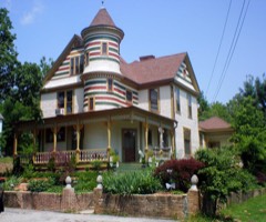 | Thomas Lawson House | 1.7 miles | 1978 |
| National Archives record | The nomination case file for reference 100001456 in Record Group 79. |
| Livingston County | All 8 listed properties in this county. |