 Block
From the record
One of 11 National Register listings published here for Caldwell County · listed in 2020 · category: Structure.
Sources: the National Register database, National Park Service
Listed on the National Register of Historic Places in 2020.
One of 11 National Register listings published here for Caldwell County · listed in 2020 · category: Structure.
Sources: the National Register database, National Park Service
Regional context, not property-specific evidence. The federal wildfire occurrence database lists 12 fires within 5 miles of State Road-Hill Cemetery Segment between 1999 and 2016, burning about 53 acres in total. None started naturally. None was recorded as arson. Distance is straight-line from the map coordinates, so a fire counted here may appear on a neighbouring settlement's page as well.
| Reported cause | Fires |
|---|---|
| Missing data/not specified/undetermined | 4 |
| Railroad operations and maintenance | 3 |
| Smoking | 2 |
| Recreation and ceremony | 2 |
| Equipment and vehicle use | 1 |
The most recent of them, most recent first, with the day each was reported and the service that recorded it.
| Date | Cause | Size | Reported by | Name on the report |
|---|---|---|---|---|
| 20 September 2004 | Missing data/not specified/undetermined | 2.0 acres | Kentucky Division of Forestry | not named |
| 17 September 1999 | Equipment and vehicle use | 1.0 acres | Kentucky Division of Forestry | not named |
| 9 August 2007 | Railroad operations and maintenance | 5.0 acres | Kentucky Division of Forestry | not named |
| 7 March 2016 | Recreation and ceremony | 15 acres | Kentucky Division of Forestry | R WHITE ROAD |
| 29 March 2006 | Missing data/not specified/undetermined | under an acre | Kentucky Division of Forestry | not named |
| 24 March 2009 | Railroad operations and maintenance | 1.0 acres | Kentucky Division of Forestry | not named |
| 3 November 2005 | Missing data/not specified/undetermined | under an acre | Kentucky Division of Forestry | not named |
| 13 November 2003 | Missing data/not specified/undetermined | 2.0 acres | Kentucky Division of Forestry | not named |
Regional context, not property-specific evidence. The federal mineral resources record lists 11 workings within 5 miles of State Road-Hill Cemetery Segment: 6 past producers, 2 producers, 2 prospects, 1 occurrence. 2 still produce. What was taken out: Fluorine-Fluorite, Zinc, Fluorine-Fluorite, Zinc, Lead, Barium-Barite, Stone, Crushed/Broken. Distance is straight-line from the map coordinates, so a quarry counted here may appear on a neighbouring settlement's page as well.
| Where | Site | Commodity | Status | Recorded |
|---|---|---|---|---|
| Eva Tanguay Mine | Fluorine-Fluorite, Zinc, Lead | Past Producer | ||
| Fredonia Quarry | Stone, Crushed/Broken | Producer | ||
| Pigmy Mine | Fluorine-Fluorite, Lead, Zinc | Past Producer | ||
| Tabb Group Fluorspar Mines | Fluorine-Fluorite, Zinc, Lead, Barium-Barite | Producer | 1903 | |
| Western Kentucky District | Fluorine-Fluorite, Zinc, Lead, Silver | Past Producer | 1914 | |
| Marble Group | Fluorine-Fluorite, Zinc | Prospect | Underground | |
| Vinson Deposit | Fluorine-Fluorite, Zinc | Prospect | 1962 | |
| Beavers Fluorite Prospect | Fluorine-Fluorite | Occurrence | ||
| S.L.Crook Mine | Fluorine-Fluorite | Past Producer | ||
| Schwench Mine | Fluorine-Fluorite | Past Producer |
Regional context, not property-specific evidence. The National Weather Service names Fredonia, the town this property stands in, in 15 storm reports between 1995 and 2023: 5 thunderstorm wind, 5 hail, 2 flood, 1 tornado. No death or injury is recorded in these reports. Each account below is quoted exactly as the forecast office filed it, from the NOAA Storm Events Database, and each date opens the federal record of that event.
| When | Event | Place named | Harm | What the report says |
|---|---|---|---|---|
| May 1995 | Tornado (F2) | Fredonia | $500,000 | The damage path began in extreme southern Crittenden County two miles south of Frances, and it ended four miles east of Fredonia in Caldwell County. The track was through sparsely populated farm country, so damage figures were relatively low for such a long track tornado. At each of five farmsteads in the direct path of the tornado, farm buildings were destroyed. Destroyed farm buildings included hen houses, hog sheds, several barns, and storage sheds. The worst damage, apparently of F2 intensity, occurred at a farm one mile south of Fredonia. About $250,000 damage occurred at this farmstead alone, where a 70 foot tall concrete silo was sheared in two. Elsewhere along the track, barns were flattened, a garage was turned sideways, and a roof was lifted off a house. Scraps of building debris were blown over a mile. A storage building at an appliance store was moved 20 to 30 feet, exposing new appliances for sale. At one residence, a child was moved off its bed moments before a 2x4 blew through the window into the child's bedroom. Damage to outdoor objects and equipment was extensive. A 1,000 gallon tank was blown away, and grain bins were moved. Fences and satellite dishes were destroyed. Damage to expensive farm equipment, such as combines and hay balers, was moderate. Along wooded sections of the damage path, every tree was snapped or uprooted. Utility poles were snapped or blown over. |
| August 2009 | Thunderstorm Wind | Fredonia | $25,000 | Widespread damaging wind gusts from 60 to 70 mph raked parts of Caldwell County. The mesonet site two miles southeast of Princeton measured a wind gust to 67 mph. A trained spotter in Princeton estimated gusts to 65 mph. Near Fredonia, two barn roofs were blown off, blocking County Road 902 East. On Highway 293 north of Princeton, a carport was blown down, and windows were blown out of a building. |
| July 2023 | Thunderstorm Wind | Fredonia | $5,000 | Trees were blown down. |
| May 1998 | Thunderstorm Wind | Fredonia | $5,000 | Thunderstorm winds downed trees and power lines at Princeton and Fredonia. |
| January 1996 | Thunderstorm Wind | Fredonia | $4,000 | no account filed |
| July 2015 | Thunderstorm Wind | Fredonia | $2,000 | Large branches were broken. |
| February 2023 | Flash Flood | Fredonia | - | Kentucky Route 91 was closed between Princeton and Fredonia due to flooding. A rainfall total of 2.51 inches was reported at Princeton for the 24-hour period. |
| March 2023 | Hail | Fredonia | - | Quarter-size hail was reported by the public and relayed through a local tv station. |
| June 2016 | Flood | Fredonia | - | A couple of inches of water was over Highway 91. |
| March 2008 | Flood | Fredonia | - | Water was over many roads, but no closures were reported. |
| June 1998 | Hail | Fredonia | - | Numerous occurrences of golf ball size hail were reported in northern Caldwell County. |
| September 2023 | Hail | Fredonia | - | no account filed |
| November 2013 | Hail | Fredonia | - | no account filed |
| April 2006 | Hail | Fredonia | - | no account filed |
| October 2006 | Heavy Rain | Fredonia | - | no account filed |
No historic map-sheet match is published for this property yet. That does not mean no map exists. This record needs a coordinate-quality review before it can be joined to a sheet boundary. Browse the county's mapped places while that work is pending.
Other National Register properties close enough to walk or drive between, ordered by distance from this one. Both positions come from the same geocoding pass that matched these properties to their map sheets.
| Photograph | Property | Distance | Listed |
|---|---|---|---|
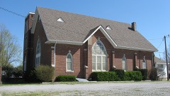 | Fredonia Cumberland Presbyterian Church | 2.4 miles | 1985 |
| National Archives record | The nomination case file for reference 100005312 in Record Group 79. |
| Caldwell County | All 11 listed properties in this county. |